
Islands
Park geography
Examining the marine territory, regional extent, and natural features of Sweden's coastal protected area.
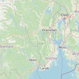
Detailed Geographic Profile and Mapped Boundaries for Kosterhavet National Park
This geographic profile presents the structural layout and environmental characteristics of Kosterhavet National Park. Analysis covers the 388.78 square kilometer protected expanse, spanning across Västra Götaland County and marine corridors. Detailed data identifies local features including bays, peaks, and coastal landforms such as Rönnevik, Pannan, and Ramnefjäll.
Sweden's first marine national park protecting the diverse waters of the Koster Islands
Kosterhavet National Park
Kosterhavet National Park is Sweden's first marine national park, established in September 2009 to protect the exceptional waters surrounding the Koster Islands in the Skagerrak Sea. Located off the coast of Bohuslän in Västra Götaland County, the park spans approximately 389 square kilometers, making it one of Sweden's largest protected marine areas. The park encompasses the sea and shores around the Koster archipelago, which consists of nearly 400 islands, though the largest islands themselves are excluded from the park boundary and protected separately as nature reserves. The marine environment within Kosterhavet stands as the most biologically diverse in Swedish waters. Over 6,000 marine species have been identified within the park, with approximately 200 of those found nowhere else in Sweden. The Kosterfjord reaches depths of 200 meters with cold, high-salinity water that supports species more typical of Atlantic conditions. The park is distinguished by having one of only two coral reefs along Sweden's coast, a rare cold-water coral formation in the deep basin known as the Säcken. This unique combination of Atlantic-influenced waters, deep fjords, and diverse habitats creates an ecological significance that extends well beyond Sweden's borders. The park shares its northern boundary with Norway's Ytre Hvaler National Park, creating a transboundary marine protected area that was established simultaneously in 2009. This connection reflects the shared ecological heritage of the Skagerrak strait, which connects the North Sea to the Baltic Sea. The park is managed by the Swedish Environmental Protection Agency in cooperation with Västra Götaland County and represents a pioneering approach to marine conservation in Scandinavia.
- Location
- Sweden
- Park type
- National park
- Established
- 2009
- Area
- 388.8 km²
Location overview
Administrative boundaries across Sweden, Denmark, and Västra Götaland
Kosterhavet National Park: Geographic Location and Borders
Kosterhavet National Park spans Sweden and Denmark, covering Västra Götaland County, Bohuslän, and Tanum. Regional borders highlight a transboundary, coastal, and marine protected environment.
- Countries
- Sweden
- Regions
- Bohuslän, Strömstad Municipality, Tanum Municipality, Västra Götaland County
- Primary location
- Västra Götaland County
- Geographic setting
- Transboundary · Coastal · Marine
Boundary and coordinates
Mapped geographic boundaries and derived spatial measurements
Kosterhavet National Park Boundary Map and Spatial Extent
Interactive boundary mapping reveals spatial context and perimeter geometry for the protected territory. Derived measurement metrics outline total surface area across the designated coordinate span.
- Boundary area
- 388 km²
- Boundary perimeter
- 207.2 km
- Northernmost point
- 59.0157° N
- Southernmost point
- 58.6797° N
- Easternmost point
- 11.1809° E
- Westernmost point
- 10.7752° E
- Geographic centre
- 58.8268° N, 11.0081° E
- North–south span
- 37.4 km
- East–west span
- 23.4 km
Terrain and natural features
Mapped coastal islands and bay entities within the protected terrain
Kosterhavet National Park Terrain and Named Natural Features
Recorded natural features include multiple islands and bays located within Kosterhavet National Park. Linked feature cards supply names, types, and spatial relationships for each entry.
Selected named natural features
Islands
Östra Kinnholmen
Islands
Hättan
Islands
Lökeskär
Bays
Lilla Båsen
Islands
Trindeknubben
Environmental setting
Marine habitats, coastal islands, and dominant water presence across the landscape
Kosterhavet National Park Environmental Settings and Physical Classifications
Recorded physical classifications outline the marine habitats, coastal islands, and dominant water presence defining the terrain. Stored categories connect directly to related atlas destinations for expanded geographical context.
- Water
- Water-dominated
- Forest cover
- No forest cover
Landscape features
Islands · Coast · Reefs
Habitat types
Marine habitat · Coastal habitat
Park atlas
Trace the regional spread of marine and coastal protected areas, comparing similar conservation landscapes and geographic contexts after Kosterhavet.
Explore National Parks and Protected Areas Near Kosterhavet, Sweden's Marine Conservation Geography
Explore additional national parks and protected areas in Sweden's coastal regions and the broader Skagerrak strait, expanding your geographic understanding beyond Kosterhavet National Park. Compare protected landscapes by marine characteristics and island geography, revealing how regional natural heritage connects with Kosterhavet's unique marine environments.
National parkØstfold
Park boundaries overlap#1 closest
North

Ytre Hvaler National Park: Norway's Coastal Marine Protected Landscape Atlas
Explore protected archipelago geography and unique cold water coral reefs.
Discover Ytre Hvaler National Park, a pivotal marine protected area on Norway's Østfold coast. This atlas entry provides detailed insight into its defining skerry landscape, the significant Tisler cold water coral reef, and its role as a protected marine ecosystem. Understand the mapped boundaries and geographic context of this unique Norwegian coastal wilderness, crucial for understanding the region's natural and maritime heritage.
- Area
- 354 km²
- Established
- 2009
- IUCN
- II
- Climate
- Temperate
National parkFærder Municipality
About 28 km away#2 closest
Northwest
Færder National Park: Norway's Coastal Archipelago & Marine Protected Area Atlas
Explore mapped landscapes and regional geography.
Færder National Park represents a significant protected landscape in Norway, characterized by its extensive marine environment and scattered archipelago. Situated east of Færder Municipality, the park's geography is defined by a mosaic of granite islands, coastal waters, and the iconic Færder Lighthouse. This entry provides atlas-level insight into the park's mapped boundaries, its role as a protected coastal ecosystem, and its contribution to the broader regional geography of Norway's southern coast.
- Area
- 340 km²
- Established
- 2013
- IUCN
- II
- Relief
- Lowland
National parkVästra Götaland County
34 km away#3 closest
Northeast

Tresticklan National Park: Preserved Old-Growth Forest on Rocky Heathland
Explore the geographic context and mapped boundaries of this vital protected area.
Tresticklan National Park is a vital protected landscape in Västra Götaland County, Sweden, safeguarding one of southern Scandinavia's most significant old-growth forest ecosystems. The park's terrain is defined by exposed granite bedrock, sparse heath pine forests, and a wild, remote character. MoriAtlas provides a structured overview of Tresticklan National Park, detailing its geographic setting and protected area status for explorers and cartographers.
- Area
- 28.97 km²
- Established
- 1996
- IUCN
- II
- Relief
- Upland
National parkTelemark
About 71 km away#4 closest
West
Jomfruland National Park: Coastal Archipelago and Skagerrak Marine Atlas
Norway's unique marine-focused national park landscape.
Jomfruland National Park is a significant protected landscape in Telemark, Norway, renowned for its coastal island geography and a landscape predominantly composed of marine waters. Covering 117 square kilometers, this national park emphasizes the conservation of both terrestrial island habitats and the surrounding Skagerrak coastal ecosystem. Explore the park's mapped boundaries and discover its regional geographic context, offering a unique perspective on Norway's protected areas and maritime natural heritage through MoriAtlas.
- Area
- 117 km²
- Established
- 2016
- IUCN
- II
- Scope
- Mixed
Nature reserveAkershus
About 99 km away#5 closest
North
Nordre Øyeren naturreservat: Mapped Geography of Norway's Largest Inland Delta
Protected wetland landscapes and river delta terrain in Akershus
The protected land of Nordre Øyeren naturreservat comprises a vast mosaic of mudflats, islands, and river channels formed where three major rivers meet lake Øyeren. This detailed atlas entry explores the geographic significance of the bird's foot delta structure, providing context on its role as a critical inland wetland for migratory waterfowl within the Akershus region.
- Area
- 62.568 km²
- Established
- 1975
- Relief
- Lowland
- Climate
- Boreal
National parkAgder
About 113 km away#6 closest
West
Raet National Park: A Coastal National Park Defined by Glacial Moraine Landscape in Agder
Explore Norway's southern coast geography and protected marine area.
Raet National Park offers a profound exploration of Norway's post-glacial landscape, anchored by its namesake 12,000-year-old glacial moraine. This unique protected area, predominantly marine, reveals a striking combination of terrestrial moraine features, extensive pebble beaches, and submerged geological formations. Understanding its mapped boundaries within Agder provides critical context for appreciating this significant coastal protected landscape, its marine ecosystems, and its role in the regional geography.
- Area
- 607 km²
- Established
- 2016
- IUCN
- II
- Relief
- Lowland
Protected areaRegion Nordjylland
128 km away#7 closest
South

Jerup Hede, Råbjerg og Tolshave Mose: Protected Area and Ridge and Pool Terrain
Geographic landscape overview in Region Nordjylland
Jerup Hede, Råbjerg og Tolshave Mose contains the largest continuous area of ridge and pool landscapes in Denmark. The site features an undulating terrain of hummocks and wet hollows typical of intact raised bogs, transitioning from inland heaths to coastal dune formations near the Skagerrak coast. It remains an essential site for studying Northern European mire ecosystems and wetland habitat patterns.
- Area
- 40.24 km²
- Relief
- Lowland
- Climate
- Temperate
- Access
- Access unknown
National parkVästra Götaland County
128 km away#8 closest
East
Djurö National Park: Sweden's Lake Archipelago National Park in Västra Götaland County
Mapped island geography and protected aquatic landscapes.
Djurö National Park stands as a singular example of Sweden's protected natural areas, characterized by its unique position as a national park comprising a complete archipelago within Lake Vänern. This page focuses on the geographic identity of Djurö National Park, detailing its island distribution, protected land status, and the distinct landscape it preserves. Users will find context for its place within Västra Götaland County, facilitating an atlas-based understanding of this exceptional aquatic environment and its mapped boundaries.
- Area
- 24 km²
- Established
- 1991
- IUCN
- II
- Relief
- Mixed relief
MoriAtlas Explorer
Continue Mapping Kosterhavet National Park's Protected Marine Geography
Deepen your understanding of Kosterhavet National Park by exploring its detailed geographic features and protected area boundaries. This marine national park offers a unique opportunity to study a vital Scandinavian ecosystem, characterized by its cold-water coral formations and significant marine biodiversity. MoriAtlas provides the tools to visualize this protected landscape and its place within the broader context of Västra Götaland County's coastal geography, inviting further atlas-driven discovery.
Browse next
Global natural geography
Explore related park routes
Explore MoriAtlas Global ParksBrowse All MoriAtlas ParksGlobal Park Map DiscoveryMoriAtlas: Browse All CountriesBrowse All MoriAtlas ContinentsNational Park Environment AtlasGrand Canyon National Park AtlasYellowstone National Park AtlasYosemite National Park Atlas and GeographySerengeti National Park AtlasGalápagos National Park Protected LandscapeBanff National Park Geography and AtlasKruger National Park Atlas EntryUluṟu-Kata Tjuṯa National Park AtlasExplore Uluru-Kata Tjuta National Park GeographyPlitvice Lakes National Park AtlasFiordland National Park Protected LandscapeGreat Smoky Mountains National Park AtlasAfghanistan National Parks and Protected AreasAlbania National Parks and Protected AreasAlgeria National Parks and Protected AreasAmerican Samoa National Parks and Protected AreasAndorra National Parks and Protected AreasAngola National Parks and Protected AreasAntarctica National Parks and Protected AreasAntigua and Barbuda Park List