Mori Atlas logo
National parkJomfruland National Park

Discover a unique archipelago national park with extensive marine protected area status.

Jomfruland National Park: Coastal Protected Landscape and Skagerrak Marine Geography

Jomfruland National Park offers a distinctive atlas exploration of Norway's southern coastline, situated in the Telemark region. This national park primarily protects the archipelago landscape of Jomfruland and Stråholmen islands, set within the marine environment of the Skagerrak strait. With approximately 98 percent of its area comprising sea waters, Jomfruland exemplifies a modern approach to conservation, integrating terrestrial island habitats with crucial coastal and maritime ecosystems. Users can discover the park's mapped boundaries, unique geographic context, and its role as a protected landscape within Norway's atlas.

coastal islandsmarine protected areaSkagerraksouthern Norwaynational parkcoastal ecosystems

Jomfruland National Park

National park

Park overview

Structured park overview, official facts, and landscape profile for Jomfruland National Park

Jomfruland National Park park facts, protected area profile, and essential visitor context
Review the core facts for Jomfruland National Park, including designation, size, terrain, visitor scale, habitats, and operating context in one park-focused overview.

About Jomfruland National Park

Jomfruland National Park protects a distinctive coastal island landscape in the southernmost region of Norway's mainland coast. The park's territory centers on two main islands, Jomfruland and Stråholmen, which rise from the waters of the Skagerrak strait. Unlike most national parks, which are predominantly terrestrial, this protected area is overwhelmingly maritime in character—approximately 98 percent of the park's 117 square kilometer area consists of sea, with the islands themselves comprising only the remaining fraction.

The Skagerrak strait, which separates southern Norway from Denmark, is a significant marine passage with complex tidal patterns and currents influenced by the meeting of North Sea and Baltic Sea waters. This maritime environment supports a distinctive coastal ecology that the park aims to preserve. The islands feature the characteristic rocky shorelines and relatively exposed terrain typical of Norway's southern coastal landscape.

The establishment of Jomfruland National Park in December 2016 represented Norway's commitment to protecting representative examples of its diverse coastal and marine environments. The park contributes to the broader network of Norwegian protected areas while specifically addressing the conservation needs of this southern coastal region. Management responsibility rests with the Norwegian Environment Agency, which oversees the preservation of both the terrestrial and marine components of the park.

Quick facts and research context for Jomfruland National Park

Jomfruland National Park is located in Kragerø Municipality, Telemark county, along Norway's southern coastline in the Skagerrak region. The park was established in December 2016, making it one of Norway's more recently designated national parks. It encompasses an area of 117 square kilometers, with the overwhelming majority of this territory being marine waters surrounding two main islands. The park is categorized as IUCN protected area management category II, denoting its status as a national park with the Norwegian Environment Agency as the governing body. The nearest town is Kragerø, a small coastal municipality with a long maritime heritage.

Park context

Deeper park guide and search-rich context for Jomfruland National Park

Jomfruland National Park history, landscape, wildlife, and travel context
Explore Jomfruland National Park through its history, landscape character, ecosystems, wildlife, conservation priorities, cultural context, and seasonal travel timing in a structured park guide built for atlas discovery and search intent.

Why Jomfruland National Park stands out

Jomfruland National Park is distinguished by its coastal island character and the unusual proportion of marine to terrestrial area within its boundaries. The park protects a representative stretch of Norway's southern Skagerrak coastline, preserving both the islands' terrestrial habitats and the surrounding coastal sea ecosystem. The presence of the historic Jomfruland lighthouse serves as a cultural landmark that anchors the islands' maritime heritage. The park's establishment in 2016 reflects a relatively recent recognition of the conservation significance of this coastal archipelago landscape.

Turquoise lake surrounded by rocky mountains with patches of snow under a partly cloudy sky
Panoramic view of turquoise lake and snow-capped mountains from Knutshøi

Jomfruland National Park history and protected-area timeline

Jomfruland National Park was established on 16 December 2016 through formal designation by the Norwegian authorities. This makes it one of the more recent additions to Norway's system of national parks, reflecting a continued evolution in the country's approach to protected area establishment. The park was created to provide formal protection for the coastal island landscape of the Jomfruland archipelago and the surrounding marine environment.

The islands themselves have a longer history of human activity and recognition. Jomfruland has been known to mariners for centuries due to its position along a historically busy shipping route through the Skagerrak. The Jomfruland lighthouse, constructed in the 19th century, stands as a testament to the islands' navigational significance and remains an important cultural feature of the landscape. While the park designation is recent, the recognition of this coastal area's value—both natural and cultural—has been building over time, culminating in the formal establishment of national park status.

Jomfruland National Park landscape and geographic character

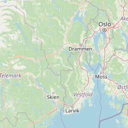
The landscape of Jomfruland National Park is defined by its coastal island setting within the Skagerrak strait. The park encompasses two primary islands—Jomfruland and Stråholmen—along with their surrounding marine waters. The islands feature relatively low-lying terrain compared to the mountainous interiors found elsewhere in Norway, with rocky coastlines that bear the mark of centuries of wave action and maritime exposure.

The surrounding sea is an integral part of the park's landscape character, not merely a backdrop to the terrestrial islands. The waters of the Skagerrak are influenced by complex tidal dynamics and the mixing of different marine environments. The coastline in this region exhibits the characteristic irregularity of Norway's southern shore, with numerous small islands, skerries, and varied shoreline profiles contributing to visual diversity.

The terrestrial portions of the islands support the vegetation types typical of Norway's southern coastal zone, with plant communities adapted to the maritime climate and exposed conditions. The interaction between land and sea defines the park's physical character, creating a landscape where the boundary between terrestrial and marine environments is deliberately blurred by the nature of the protected area.

Jomfruland National Park ecosystems, habitats, and plant life

The nature of Jomfruland National Park reflects its position in the Skagerrak coastal zone, a marine environment of significant ecological importance. The park protects a representative example of Norway's southern coastal and island ecosystems, encompassing both the terrestrial habitats of the islands themselves and the surrounding marine waters. This dual terrestrial-marine character is unusual among Norwegian protected areas and reflects an integrated approach to coastal conservation.

The marine environment of the Skagerrak supports diverse coastal ecosystems influenced by the mixing of North Sea and Baltic Sea waters. The water column and seafloor habitats within the park's boundaries receive protection as part of the overall conservation framework. The transitional nature of this marine area—where different water masses meet—creates conditions that support varied marine life.

The terrestrial nature of the islands, though occupying only a small fraction of the total park area, includes coastal heath, rocky terrain, and the plant communities adapted to the salt-laden winds and relatively mild maritime climate of southern Norway. These habitats support specialized plant species adapted to the challenging coastal conditions.

Jomfruland National Park wildlife and species highlights

The wildlife of Jomfruland National Park reflects its position in the Skagerrak region, a marine corridor of significant ecological importance for coastal and seabird species. The islands and surrounding waters provide habitat for various bird species that depend on coastal and marine environments. TheSkagerrak strait is an important passage for migratory birds and supports populations of seabirds that use the islands for breeding and resting.

The marine waters within the park protect the fish and invertebrate communities that inhabit Norway's southern coastal zone. The mixing of different marine environments in the Skagerrak creates a biodiverse transition zone that supports species with varying salinity and temperature tolerances. While detailed species inventories are limited in the available source material, the protected area ensures the preservation of these coastal and marine wildlife communities as part of the broader ecological system.

Jomfruland National Park conservation status and protection priorities

Jomfruland National Park contributes to Norway's conservation framework by protecting a coastal island ecosystem that had not previously received formal national park status. The park's establishment in 2016 added a representative coastal protected area to Norway's network of national parks, specifically addressing the need to preserve the marine and island environments of the southern Skagerrak coast.

The park's designation as IUCN category II reflects its status as a national park with the primary objectives of ecosystem conservation and protection. By encompassing both islands and surrounding sea in a single protected area, the park takes an integrated approach to coastal conservation that recognizes the interdependence of terrestrial and marine habitats. The management by the Norwegian Environment Agency ensures coordinated protection of both components of the park.

This conservation designation recognizes the ecological value of Norway's southern coastal waters and the importance of protecting transitional marine environments that support diverse species communities. The park contributes to broader marine conservation objectives while preserving the cultural landscape character of the islands.

Jomfruland National Park cultural meaning and human context

The cultural context of Jomfruland National Park is deeply intertwined with maritime history and the islands' long relationship with seafaring and navigation. The Jomfruland lighthouse, constructed in the 19th century, stands as a prominent cultural landmark and symbolizes the islands' historic role in guiding ships through the challenging waters of the Skagerrak strait. This lighthouse remains an important visual and cultural element of the park's character.

The archipelago has been part of Norway's coastal cultural landscape for centuries, with human presence and activity shaping—and being shaped by—the maritime environment. Fishing, shipping, and coastal trade have historically been central to life in this region, creating cultural connections to the sea that remain significant. The establishment of the national park preserves not only the natural environment but also the cultural heritage embedded in this coastal landscape.

The park's cultural context reflects the broader pattern of Norwegian coastal communities whose identities have been formed by their relationship with the sea. While the national park designation is recent, the cultural layer of human activity on these islands extends far back, adding historical depth to the protected area's character.

Top sights and standout views in Jomfruland National Park

Jomfruland National Park stands out for its unusual composition as a predominantly marine protected area, with approximately 98 percent of its 117 square kilometer extent consisting of sea surrounding two coastal islands. The park protects a representative example of Norway's southern Skagerrak coastal ecosystem, an area of significant marine ecological value where different water masses interact. The historic Jomfruland lighthouse provides a cultural landmark that anchors the islands' maritime heritage, while the park's recent establishment in 2016 reflects contemporary conservation priorities. The integrated protection of both island and surrounding sea makes this park distinctive within Norway's national park system.

Best time to visit Jomfruland National Park

The character of Jomfruland National Park is shaped by its maritime setting in southern Norway's Skagerrak region. The coastal location means that the park experiences a relatively mild climate compared to more northerly parts of Norway, though visitors should expect the wind and weather patterns typical of exposed coastal environments. The summer months generally offer the most stable conditions for visiting, with longer daylight hours and calmer seas facilitating exploration of the island landscapes.

The shoulder seasons of spring and autumn can also offer rewarding visits, though with more variable weather conditions. The maritime character of the park means that the surrounding waters are integral to the visitor experience, and conditions at sea will influence overall visitability. Winter visits are possible but the coastal climate can bring challenging weather. The best approach for planning a visit would be to check current conditions and any access restrictions, as the park's island setting and marine focus mean that boat access is typically required.

Park location guide

Geography guide, regional context, and park location map for Jomfruland National Park

Jomfruland National Park park geography, regions, and map view in Norway
Understand where Jomfruland National Park sits in Norway through a broader geographic reading of the surrounding landscape, nearby location context, and its mapped position within the national park landscape.

How Jomfruland National Park fits into Norway

Norway, officially the Kingdom of Norway, is a Nordic country in Northern Europe located on the Scandinavian Peninsula. It encompasses mainland Norway, the Arctic islands of Svalbard and Jan Mayen, and maintains dependencies including Bouvet Island and Antarctic claims. The country has a population of about 5.6 million and is bordered by Sweden, Finland, and Russia. Norway is a unitary parliamentary constitutional monarchy with Oslo as its capital and largest city.

Wider geography shaping Jomfruland National Park in Norway

Norway occupies the western and northern portions of the Scandinavian Peninsula in Northern Europe. The country shares a long eastern border with Sweden, and borders Finland and Russia to the northeast. Norway has an extensive coastline facing the Skagerrak, North Sea, Norwegian Sea, and Barents Sea. The terrain is predominantly mountainous with numerous fjords along the coastline.

Map view of Jomfruland National Park

Use this park location map to pinpoint Jomfruland National Park in Norway, understand its exact geographic position, and read its mapped placement within the surrounding landscape more clearly.

Pigeon | © OpenStreetMap contributors

Location context for Jomfruland National Park

Kragerø MunicipalityTelemark

Visual Guide to Jomfruland's Protected Coastal Islands and the Skagerrak Strait Marine Ecosystem

Jomfruland National Park Photos: Coastal Landscapes, Marine Scenery, and Island Environment
Explore Jomfruland National Park photos to visually understand its distinctive coastal island landscapes, rocky shorelines, and the extensive marine protected area of the Skagerrak strait. These images provide essential insights into the park's unique environment, showcasing the integration of land and sea that defines this crucial southern Norway conservation zone.

Turquoise lake surrounded by rocky mountains with patches of snow under a partly cloudy sky

Park atlas

Compare park geography and protected landscapes across Telemark county and southern Norway.

Discover Nearby National Parks and Protected Areas Around Jomfruland National Park, Telemark
Continue your park exploration beyond Jomfruland National Park by browsing other national parks and protected areas across Telemark county and the wider southern Norway coastline. Discover and compare diverse protected landscapes, encompassing marine environments, coastal archipelagos, and inland forest reserves, gaining essential geographic context for regional conservation.
Watercolor painting of coastal waters, islands, rocky shore, and distant hills
National parkAgder

Raet National Park: A Coastal National Park Defined by Glacial Moraine Landscape in Agder

Explore Norway's southern coast geography and protected marine area.

Raet National Park offers a profound exploration of Norway's post-glacial landscape, anchored by its namesake 12,000-year-old glacial moraine. This unique protected area, predominantly marine, reveals a striking combination of terrestrial moraine features, extensive pebble beaches, and submerged geological formations. Understanding its mapped boundaries within Agder provides critical context for appreciating this significant coastal protected landscape, its marine ecosystems, and its role in the regional geography.

Area
607 km²
Established
2016
IUCN
II
Relief
Lowland
Watercolor illustration of a coastal landscape with reeds in shallow water and distant green hills under a pale yellow sky
National parkFærder Municipality

Færder National Park: Norway's Coastal Archipelago & Marine Protected Area Atlas

Explore mapped landscapes and regional geography.

Færder National Park represents a significant protected landscape in Norway, characterized by its extensive marine environment and scattered archipelago. Situated east of Færder Municipality, the park's geography is defined by a mosaic of granite islands, coastal waters, and the iconic Færder Lighthouse. This entry provides atlas-level insight into the park's mapped boundaries, its role as a protected coastal ecosystem, and its contribution to the broader regional geography of Norway's southern coast.

Area
340 km²
Established
2013
IUCN
II
Relief
Lowland
National parkVästra Götaland County

Kosterhavet National Park: A Marine National Park Exploring Unique Archipelago Geography

Discover its mapped underwater terrain and rich marine biodiversity.

Kosterhavet National Park, located in Västra Götaland County, is Sweden's first marine national park, dedicated to protecting the unique aquatic environment of the Koster Islands. This protected area is renowned for its exceptional marine biodiversity, including rare cold-water coral reefs and the country's largest seal colony, all situated within a dramatic underwater geography characterized by deep fjords. Use MoriAtlas to explore the mapped extent of this vital marine protected landscape and understand its significant place in regional and national conservation efforts.

Area
388.78 km²
Established
2009
IUCN
II
Visitors
90K annual
National parkØstfold

Ytre Hvaler National Park: Norway's Coastal Marine Protected Landscape Atlas

Explore protected archipelago geography and unique cold water coral reefs.

Discover Ytre Hvaler National Park, a pivotal marine protected area on Norway's Østfold coast. This atlas entry provides detailed insight into its defining skerry landscape, the significant Tisler cold water coral reef, and its role as a protected marine ecosystem. Understand the mapped boundaries and geographic context of this unique Norwegian coastal wilderness, crucial for understanding the region's natural and maritime heritage.

Area
354 km²
Established
2009
IUCN
II
National parkVästra Götaland County

Tresticklan National Park: Preserved Old-Growth Forest on Rocky Heathland

Explore the geographic context and mapped boundaries of this vital protected area.

Tresticklan National Park is a vital protected landscape in Västra Götaland County, Sweden, safeguarding one of southern Scandinavia's most significant old-growth forest ecosystems. The park's terrain is defined by exposed granite bedrock, sparse heath pine forests, and a wild, remote character. MoriAtlas provides a structured overview of Tresticklan National Park, detailing its geographic setting and protected area status for explorers and cartographers.

Area
28.97 km²
Established
1996
IUCN
II
Relief
Upland
National parkVestland

Hardangervidda National Park: Vast Arctic Plateau and European Peneplain Discovery

Explore Norway's largest national park and its unique tundra ecosystem.

Delve into the geography of Hardangervidda National Park, Norway's largest national park, featuring the expansive Arctic plateau and Europe's largest peneplain. This protected landscape offers a unique mapped environment characterized by treeless moorland, numerous lakes, and important wildlife habitats, including significant wild reindeer populations. Understand its position within the Vestland region and its value as a key protected area for geographic exploration and landscape context.

Area
3,422 km²
Established
1981
IUCN
II
Relief
Highland
Abstract watercolor landscape with soft pastel hues of green, pink, yellow, and purple
National park

Hallingskarvet National Park: Norway's High Mountain Plateau and Protected Wilderness

Mapping glacial terrain, alpine environments, and wild reindeer habitat.

Hallingskarvet National Park offers a unique window into Norway's geological history and alpine ecology. This protected landscape encompasses the striking Hallingskarvet plateau and the Vargebreen glacier, along with deep valleys carved by ancient ice. Users can explore the park's mapped boundaries, understand its regional geographic setting in Scandinavia, and appreciate its conservation value as a habitat for wild reindeer. The park's terrain provides a concrete example of glacial shaping and high-altitude ecosystems within the Nordic context.

Area
450 km²
Established
2006
IUCN
II
Relief
Mountain
Watercolor illustration of a landscape with trees, water, and distant hills
National park

Thy National Park: Explore Denmark's First Protected Coastal Landscape and Heathlands

Mapped dune systems, rare heath habitats, and coastal geography.

Thy National Park, Denmark's inaugural national park, protects a significant expanse of windswept coastal terrain. This area is renowned for its rare dune heaths, a habitat of particular European ecological importance, and a landscape shaped by a century of sand drift stabilization efforts. The park's diverse geography includes extensive sandy heaths, conifer plantations, and a striking coastline along the North Sea, offering rich opportunities for atlas exploration of protected natural areas and their surrounding regional context. Discover the mapped extent of this vital conservation landscape.

Area
244 km²
Established
2007
Relief
Lowland
Climate
Temperate

Common questions about visiting, size, designation, and location context for Jomfruland National Park

Jomfruland National Park FAQs for park facts, access, geography, and protected area context
Find quick answers about Jomfruland National Park, including protected-area facts, park geography, trail and visitor context, and how the park fits into its surrounding country and regional landscape.
MoriAtlas Explorer

Continue Your Protected Areas Search Across the Global Atlas

Deepen your exploration by continuing the structured search for national parks and protected areas worldwide. Utilize the comprehensive filtering capabilities to compare different conservation landscapes and refine your understanding of global park geography. Discover more about the distribution and characteristics of protected natural areas.

Global natural geography