

Mori Atlas logo
National parkLaem Son National Park

Discover the mapped boundaries and regional geography of this protected natural area.

Laem Son National Park: Protected Landscape and Geographic Context in Ranong, Thailand

(Kaper Estuary - Laemson Marine National Park - Kraburi Estuary)

Laem Son National Park stands as a protected national park within the Ranong region of Thailand, offering a distinct geographic identity for atlas-based exploration. This page serves as a focal point for understanding the park's protected landscape, its mapped boundaries, and its place within the surrounding natural terrain. Investigate the structured geographic data and context that define Laem Son National Park for meaningful discovery.

Coastal National ParkMangrove EcosystemsAndaman SeaRamsar WetlandOffshore IslandsCoral Reefs

Laem Son National Park

National park

Park overview

Structured park overview, official facts, and landscape profile for Laem Son National Park

Laem Son National Park park facts, protected area profile, and essential visitor context

Review the core facts for Laem Son National Park, including designation, size, terrain, visitor scale, habitats, and operating context in one park-focused overview.

About Laem Son National Park

Laem Son National Park represents one of Thailand's most significant coastal protected areas, preserving a diverse array of marine, wetland, and terrestrial ecosystems along the Andaman Sea. The park's 100-kilometer coastline encompasses sandy beaches, rocky headlands, coral reef formations, and extensive mangrove forests that provide critical habitat for both marine and terrestrial species. The protected area extends offshore to include approximately twenty islands, some of which support unique ecological communities and remain relatively undisturbed by development. The park's establishment in 1983 reflected growing recognition of the ecological value of Thailand's coastal zones and the need to protect significant habitat from expanding tourism and development pressures along the Andaman coast. Its designation as a Ramsar Wetland in 2002 further elevated its conservation profile, recognizing the international significance of its estuary ecosystems. The park's remote location has helped maintain its wilderness character, though visitor infrastructure exists at the headquarters area.

Quick facts and research context for Laem Son National Park

Laem Son National Park occupies the southwestern coast of Thailand in Ranong and Phangnga provinces, approximately 60 kilometers south of Ranong town. The park protects 100 kilometers of Andaman Sea coastline, the longest protected shore in Thailand. It was established in 1983 and designated as a Ramsar Wetland in 2002, covering the Kaper Estuary, Laemson Marine, and Kraburi River Estuary areas. The park's coastal geography includes sandy beaches, coral reef systems, dense mangrove forests, and lowland rainforest, with numerous offshore islands including Ko Kam Yai, Ko Kam Noi, Ko Khangkhao, and Ko Phayam.

Protection and recognition

Geographic tracking of global treaty designations and national conservation records

Laem Son National Park Protection Status and Ramsar Designation Facts

Established in 1983, Laem Son National Park maintains a mixed protection scope encompassing both terrestrial and marine environments. Global environmental treaty records recognize the area under the Kaper Estuary, Laemson Marine National Park, and Kraburi Estuary Ramsar designation.

International recognition

Protection details

Protection scope
Mixed
Designated year
1983
Park context

Deeper park guide and search-rich context for Laem Son National Park

Laem Son National Park history, landscape, wildlife, and travel context

Explore Laem Son National Park through its history, landscape character, ecosystems, wildlife, conservation priorities, cultural context, and seasonal travel timing in a structured park guide built for atlas discovery and search intent.

Why Laem Son National Park stands out

Laem Son National Park is best known for its exceptional coastal protected area status, holding Thailand's longest stretch of protected shoreline along the Andaman Sea. The park's mangrove ecosystems are ecologically significant, supporting dense forest coverage and serving as critical nurseries for marine species. Its offshore islands provide important seabird and marine habitats. The population of long-tailed macaques on Piak Nam Yai and Thao islands has been documented using stone tools, a rare behavioral adaptation among Thailand's primates. The Ramsar-designated estuary areas at Kaper and Kraburi represent significant wetland conservation zones within the park's boundaries.

Laem Son National Park history and protected-area timeline

Laem Son National Park was established in 1983 as Thailand's response to growing concerns about coastal ecosystem degradation and the need to preserve significant marine and wetland habitats along the Andaman Sea coast. The park was initially focused on protecting the coastal and marine environments of the Laem Son peninsula area, taking its name from the pine-covered cape that defines its central landscape feature. In 2002, the protected area's conservation significance was further recognized through Ramsar Convention designation, which incorporated the Kaper Estuary and Kraburi River Estuary into the park's protected zone, officially becoming known as Kaper Estuary - Laemson Marine National Park - Kraburi Estuary. The park suffered significant damage during the 2004 Indian Ocean earthquake and tsunami, which destroyed the park headquarters and physically altered the coastline at Ao Khao Khwai, splitting what was previously a single bay into two distinct islands. Post-tsunami recovery has included restoration of park facilities and collaborative mangrove restoration projects with institutional partners.

Laem Son National Park landscape and geographic character

Laem Son National Park presents a diverse coastal landscape characterized by its long stretch of Andaman Sea shoreline, sandy beaches, and offshore island chain. The park's mainland terrain features lowland areas transitioning from beach zones through coastal mangrove swamps to lowland rainforest. The peninsula at Laem Son itself is noted for the pine-covered cape that gives the park its name, a distinctive feature along the otherwise tropical coastline. Visible from beaches such as Hat Bang Ben, approximately twenty offshore islands dot the Andaman Sea, including Ko Kam Yai, Ko Kam Noi, Mu Ko Yipun, Ko Khangkhao, and Ko Phayam. These islands range from small rocky outcrops to larger landmasses with their own beach and vegetation. The estuary systems at Kaper and Kraburi create productive wetland zones where freshwater meets the sea, supporting distinct ecological communities adapted to brackish water conditions.

Laem Son National Park ecosystems, habitats, and plant life

The park protects extensive mangrove ecosystems that form dense forest coverage along tidal channels and estuary areas. These mangrove systems serve critical ecological functions as nursery grounds for juvenile fish, crustaceans, and other marine species, while also stabilizing coastlines and filtering sediment from incoming water. The coastal rainforest areas support diverse terrestrial plant communities adapted to the tropical environment. Coral reef systems occur in nearshore waters, providing habitat for reef fish and other marine organisms. The Ramsar-designated wetland areas at Kaper Estuary and Kraburi Estuary represent particularly significant habitat zones for waterbirds and migratory species. The park's position along the Andaman Sea places it within a broader ecological corridor connecting coastal ecosystems across the region.

Laem Son National Park wildlife and species highlights

Laem Son National Park supports significant wildlife populations across its marine, wetland, and terrestrial habitats. The mangrove and estuary areas provide crucial feeding and nesting grounds for waterbirds, including species that utilize the East Asian-Australasian flyway. The marine environment supports coral reef communities with associated fish species, while the offshore islands serve as roosting sites for seabirds. A particularly notable population of long-tailed macaques inhabits the islands of Piak Nam Yai and Thao, where researchers have documented their use of stone tools for foraging. This behavioral adaptation, involving the selection and use of rocks to crack open hard-shelled prey, represents a rare example of tool use among primates in Thailand and has attracted scientific attention to the park's primate populations.

Laem Son National Park conservation status and protection priorities

Laem Son National Park holds significant conservation value as Thailand's longest stretch of protected coastline and as a designated Ramsar Wetland site. The Ramsar designation in 2002 recognized the international importance of the park's estuary ecosystems at Kaper and Kraburi, which provide essential habitat for migratory waterbirds and support complex food webs in brackish water environments. The park's mangrove forests represent important blue carbon ecosystems that sequester significant amounts of carbon while providing coastal protection and supporting marine biodiversity. Post-2004 tsunami recovery efforts have included collaborative mangrove restoration projects with institutional partners, addressing both ecological recovery and habitat protection objectives. The park's IUCN Category II designation reflects its management as a national park with primary conservation objectives alongside limited sustainable visitor use.

Laem Son National Park cultural meaning and human context

The Laem Son area has historical connections to coastal communities that have utilized the marine and mangrove resources of the region for generations. The estuary areas at Kaper and Kraburi have historically supported local fishing communities and traditional land use practices. The park's location in the Ranong and Phangnga provinces places it within a region with its own distinct cultural heritage along the Andaman coast. The use of stone tools by macaques on certain islands represents an unusual natural phenomenon that has drawn attention to the park's ecological distinctiveness, though this is a natural behavioral adaptation rather than human cultural heritage.

Top sights and standout views in Laem Son National Park

Laem Son National Park offers Thailand's longest protected coastline with over 100 kilometers of accessible Andaman Sea shoreline. The park's diverse habitats range from pine-covered headlands at Cape Laem Son through extensive mangrove forests to coral reefs and offshore islands. The Ramsar-designated wetland areas at Kaper and Kraburi estuaries represent internationally significant bird habitat. Notable wildlife includes populations of long-tailed macaques using stone tools on specific islands. The park's relative remoteness and limited development provide a more wilderness-oriented experience compared to more heavily visited Thai coastal destinations.

Best time to visit Laem Son National Park

The optimal visiting period for Laem Son National Park corresponds to Thailand's dry season, typically from November through April, when rainfall is minimal and conditions are most suitable for outdoor exploration and beach activities. The monsoon season from May through October brings heavier rainfall and rougher seas, which may affect accessibility of certain areas and reduce visibility for marine activities. Visitor numbers tend to be lower during the shoulder seasons, offering a more secluded experience in the park's coastal and forest environments.
Monthly climate preview

Historical temperature cycles and monthly rainfall averages near Ranong

Laem Son National Park Monthly Climate Normals and Average Temperature

Long term baseline measurements at Laem Son National Park indicate warm temperatures year round paired with a highly variable precipitation cycle that peaks dramatically from May through October. Comparing the twelve-month historical profile reveals the precise distribution of daily rainfall averages and monthly temperature ranges across the park.
Annual mean25 °C
24 °C27 °C
Jan24°
Feb24°
Mar26°
Apr27°
May26°
Jun25°
Jul25°
Aug25°
Sep25°
Oct25°
Nov25°
Dec24°
Warmest month
April

27.1 °C

Coolest month
January

23.8 °C

Wettest month
September

12.4 mm/day

Driest month
February

1.1 mm/day

Park location guide

Geography guide, regional context, and park location map for Laem Son National Park

Laem Son National Park park geography, regions, and map view in Thailand

Understand where Laem Son National Park sits in Thailand through a broader geographic reading of the surrounding landscape, nearby location context, and its mapped position within the national park landscape.

How Laem Son National Park fits into Thailand

Thailand is a Southeast Asian nation formerly called Siam, located in mainland Southeast Asia. It operates as a unitary parliamentary constitutional monarchy under King Vajiralongkorn. The country borders Myanmar, Laos, Cambodia, and Malaysia, with maritime boundaries involving Vietnam, Indonesia, and India. Thailand has a population of nearly 66 million and covers approximately 513,120 km². Historically, the Sukhothai Kingdom marks the beginning of Thai history, followed by the powerful Ayutthaya Kingdom.

Wider geography shaping Laem Son National Park in Thailand

Thailand occupies mainland Southeast Asia with borders to Myanmar (west/northwest), Laos (east/northeast), Cambodia (southeast), and Malaysia (south). The country has coastline along the Gulf of Thailand to the southeast and the Andaman Sea to the southwest. The territory covers approximately 513,120 km².

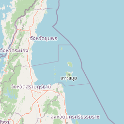
Map view of Laem Son National Park

Use this park location map to pinpoint Laem Son National Park in Thailand, understand its exact geographic position, and read its mapped placement within the surrounding landscape more clearly.

Pigeon | © OpenStreetMap contributors

Location context for Laem Son National Park

Phangnga ProvinceRanong Province
Park atlas

Trace the regional park geography across Thailand's Andaman Sea coast, comparing protected areas and coastal ecosystems.

Explore Nearby National Parks and Coastal Protected Areas Beyond Laem Son National Park

After exploring Laem Son National Park's unique coastal protected areas, continue your discovery by browsing other national parks and protected landscapes across the wider Andaman Sea region. Compare diverse coastal habitats, island ecosystems, and marine conservation zones to understand their regional distribution and ecological connections.
National parkPhang Nga Province
About 50 km away#1 closest

South

Si Phang-nga National Park: Protected Landscape Identity and Geographic Context in Phang Nga

Explore the park's mapped boundaries and unique karst landscape.

Si Phang-nga National Park stands as a key protected area, distinguished by its extraordinary limestone karst formations that dominate the coastal geography of Phang Nga Province, Thailand. The park's protected landscape features include dramatic pinnacles rising from mangrove-lined waters and intricate cave systems with archaeological significance. Delve into the unique natural terrain and map context that define this vital national park, offering a deep dive into its geological history and ecological importance.

Area
246 km²
Established
1988
IUCN
II
Visitors
21.3K annual
National parkSurat Thani Province
About 55 km away#2 closest

Southeast

Kaeng Krung National Park: Exploring Protected Area Boundaries and Regional Geography

A National Park within Surat Thani Province's diverse landscapes.

Kaeng Krung National Park is a distinct protected area situated in Surat Thani Province, Thailand. This page provides essential context for understanding the park's geographic significance, its mapped boundaries, and its contribution to the regional protected landscape atlas. Explore the fundamental geographic characteristics that define this important natural reserve and its surrounding terrain.

Area
541 km²
Established
1991
IUCN
II
Visitors
909 annual
National parkThailand
About 69 km away#3 closest

West

Mu Ko Surin National Park: Mapped Marine Protected Area in Thailand's Andaman Sea

Explore unique island geography and vibrant coral reef landscapes.

Mu Ko Surin National Park is a national park comprising a series of islands within Thailand's Andaman Sea, recognized for its exceptional marine biodiversity and well-preserved coral reefs. This protected area showcases a distinctive landscape where dense tropical forests meet extensive underwater ecosystems, offering a prime example of coastal natural geography. Understanding Mu Ko Surin National Park through its mapped boundaries and ecological significance provides valuable insight into Thailand's protected natural heritage and its role in regional conservation.

IUCN
II
Scope
Marine
National parkSurat Thani Province
About 74 km away#4 closest

South

Khao Sok National Park: Protected Landscape Atlas and Geographic Detail

Explore mapped boundaries and regional terrain in Surat Thani Province.

Khao Sok National Park represents a crucial protected landscape within the expansive geography of Surat Thani Province, Thailand. This detailed entry focuses on the park's identity as a national park, emphasizing its mapped boundaries and the surrounding natural terrain. Through structured information and geographic context, users can gain a clear understanding of Khao Sok National Park's place in the atlas, contributing to a more informed approach to landscape discovery.

Area
739 km²
Established
1980
IUCN
II
Visitors
419.5K annual
National parkSurat Thani Province
About 86 km away#5 closest

South

Khlong Phanom National Park: Protected National Park in Surat Thani Province, Southern Thailand

Discover its mapped boundaries and regional landscape context.

Khlong Phanom National Park is a designated national park providing valuable insight into the natural geography of Surat Thani Province. This protected landscape serves as a key entity for understanding regional terrain and the distribution of conservation areas in Southern Thailand. Explore its mapped geographic features and protected boundaries to gain a structured understanding of its place within the national park atlas.

Area
410 km²
Established
2000
IUCN
II
Visitors
1.7K annual
National parkPhang Nga Province
About 102 km away#6 closest

South

Khao Lak, Lam Ru National Park: Protected National Park Landscape and Geography

Explore its mapped boundaries and regional context in Phang Nga Province.

This entry focuses on Khao Lak, Lam Ru National Park, a designated national park offering a distinct protected landscape within Phang Nga Province, Thailand. It provides structured data and map context crucial for understanding its geographic scope and regional significance. Explore the park's mapped boundaries, its role as a protected area, and its contribution to the broader landscape of southern Thailand, fostering a deeper appreciation for its natural geography and atlas-derived insights.

Area
125 km²
Established
1991
IUCN
II
Visitors
72.2K annual
National parkChumphon Province
About 109 km away#7 closest

Northeast

Mu Ko Chumphon National Park: Mapped Archipelago and Marine Protected Landscape

Explore island geography and tropical rainforests in Chumphon Province.

Mu Ko Chumphon National Park offers a deep dive into an island archipelago landscape located in Chumphon Province. This protected area is characterized by numerous islands featuring tropical rainforests atop hilly terrain that slopes down to white-sand beaches and clear gulf waters. Examine the mapped extent of its protected marine environment and the diverse ecosystems supporting coral reefs and unique swiftlet nesting sites, providing a rich geographic context for atlas exploration.

Area
317 km²
Established
1999
IUCN
II
Relief
Mixed relief
National parkSurat Thani Province
About 130 km away#8 closest

East

Mu Ko Ang Thong National Park: National Park with Distinct Protected Landscape and Geographic Context

Explore mapped boundaries within Surat Thani Province, Thailand.

Mu Ko Ang Thong National Park serves as a key protected area, offering a focused study of its specific geography and landscape features within the broader atlas of Surat Thani Province. As a national park, its mapped boundaries are crucial for understanding conservation landscapes in this part of southern Thailand. Users exploring this destination will find detailed context on its natural terrain and regional geographic placement.

Area
102 km²
Established
1980
IUCN
II
Visitors
134.3K annual

Common questions about visiting, size, designation, and location context for Laem Son National Park

Laem Son National Park FAQs for park facts, access, geography, and protected area context

Find quick answers about Laem Son National Park, including protected-area facts, park geography, trail and visitor context, and how the park fits into its surrounding country and regional landscape.
MoriAtlas Explorer

Continue Your Protected Areas Search Across the Global Atlas

Deepen your exploration by continuing the structured search for national parks and protected areas worldwide. Utilize the comprehensive filtering capabilities to compare different conservation landscapes and refine your understanding of global park geography. Discover more about the distribution and characteristics of protected natural areas.

Global natural geography