

Mori Atlas logo
National parkAo Phang Nga National Park

Discover the mapped geographic context and protected area identity of Ao Phang Nga National Park.

Ao Phang Nga National Park: Thailand's Protected Landscape and National Park Atlas Entry

(Phang Nga Bay Marine National Park)

Ao Phang Nga National Park represents a significant protected national park within Thailand's diverse geography. This entry provides detailed information on its mapped boundaries and landscape context, essential for understanding its role within the regional atlas of conservation areas. Explore the geographic specifics and protected land attributes that define Ao Phang Nga National Park and its place in Thailand's natural heritage.

Limestone Karst IslandsMangrove ForestMarine National ParkRamsar WetlandSoutheast Asian IslandsTower Karst

Ao Phang Nga National Park

National park

Park overview

Structured park overview, official facts, and landscape profile for Ao Phang Nga National Park

Ao Phang Nga National Park park facts, protected area profile, and essential visitor context
Review the core facts for Ao Phang Nga National Park, including designation, size, terrain, visitor scale, habitats, and operating context in one park-focused overview.

About Ao Phang Nga National Park

Ao Phang Nga National Park represents a unique fusion of terrestrial and marine ecosystems along Thailand's southwestern coast. The park's defining characteristic is its collection of dozens of limestone islands scattered across Phang Nga Bay, their steep vertical cliffs rising hundreds of meters from the water and creating a landscape of exceptional visual drama. These tower karst formations originated during the Cretaceous to early Tertiary period, approximately 136 to 36 million years ago, shaped by structural geological forces including the Khlong Marui and Phang Nga faults. The park's marine areas encompass both open water and extensive mangrove systems, with the mangrove forest representing the largest remaining example of this habitat type in Thailand. This coastal ecosystem plays an indispensable role in protecting shorelines from storms and serving as a nursery area for commercially important fish and crustacean species. The park's designation as a Ramsar Wetland in 2002 further underscores its international ecological significance, recognizing it as a wetland of importance beyond national boundaries.

Quick facts and research context for Ao Phang Nga National Park

Ao Phang Nga National Park spans roughly 400 square kilometers along the Strait of Malacca in southern Thailand's Phang Nga Province. The park is centered around Phang Nga Bay, a maritime landscape famous for its dozens of limestone islands with steep, sheer cliffs rising dramatically from the water. The park was officially established in 1981 and also carries Ramsar Wetland designation, highlighting its international conservation importance. The area receives approximately one million visitors annually, though concerns about overtourism led to recommendations for temporary reduced visitation to allow environmental recovery.

Park context

Deeper park guide and search-rich context for Ao Phang Nga National Park

Ao Phang Nga National Park history, landscape, wildlife, and travel context
Explore Ao Phang Nga National Park through its history, landscape character, ecosystems, wildlife, conservation priorities, cultural context, and seasonal travel timing in a structured park guide built for atlas discovery and search intent.

Why Ao Phang Nga National Park stands out

Ao Phang Nga National Park is best known for its extraordinary limestone tower karst islands that create one of Thailand's most recognizable seascapes. The most famous of these is Khao Phing Kan, nicknamed James Bond Island after its appearance in the 1974 James Bond film The Man with the Golden Gun. The park is equally significant for protecting Thailand's largest remaining tract of原生 mangrove forest, a critical coastal ecosystem that serves as a natural barrier against storms and provides vital breeding grounds for marine species. The combination of dramatic karst topography, extensive mangroves, and rich marine biodiversity makes this park a flagship example of tropical island and coastal conservation in Southeast Asia.

Ao Phang Nga National Park history and protected-area timeline

Ao Phang Nga National Park was formally established through a royal decree published in the Royal Gazette under proclamation number 98, section 64, dated April 29, 1981. The initial designation covered an area of approximately 250,000 rai, equivalent to about 400 square kilometers. Beyond its national park status, the area received additional international recognition when it was designated as a Ramsar Wetland on August 14, 2002, under the Ramsar Convention on Wetlands, reflecting its exceptional value as a coastal and marine wetland ecosystem. Archaeological research conducted in 1987 at Khao Tao within the park uncovered prehistoric human burial sites, providing evidence of early human habitation in the Phang Nga Bay area. Studies of cave deposits and island formations have revealed the geological history of the region, including significant sea level fluctuations during the Pleistocene and Holocene epochs that shaped the current island landscape.

Ao Phang Nga National Park landscape and geographic character

The landscape of Ao Phang Nga National Park is defined by its predominantly maritime environment and the extraordinary limestone tower karst formations that populate Phang Nga Bay. These islands feature steep, sheer sides that rise abruptly from the water, creating dramatic cliffs and vertical rock faces. The underlying geology consists of a combination of sedimentary and metamorphic rock formations, with the limestone mountains containing numerous caves and natural holes formed through geological processes over millions of years. The park's coastal areas include extensive mangrove forests along sheltered shorelines and river channels, while the surrounding waters of the Strait of Malacca vary in depth and character. The terrestrial portions of the islands support tropical rainforest vegetation, adding green canopy to the otherwise stark limestone silhouettes. This distinctive combination of vertical limestone peaks, winding water channels through mangroves, and open marine waters creates a landscape of remarkable diversity and visual complexity.

Ao Phang Nga National Park ecosystems, habitats, and plant life

The ecological character of Ao Phang Nga National Park centers on two primary habitat types: the extensive mangrove forest and the tropical rainforest covering the islands. The mangrove ecosystem represents the largest remaining example of this habitat in Thailand, characterized by species including Rhizophora apiculata, Rhizophora mucronata, Avicennia alba, Avicennia officinalis, Bruguiera cylindrica, and Bruguiera parviflora, along with cannonball trees (Xylocarpus granatum and Xylocarpus moluccensis). These mangrove forests form a critical component of the coastal environment, functioning as natural barriers against storm surges and providing essential breeding and nursery habitat for diverse marine species. The islands support tropical rainforests containing species such as Hopea ferrea, Parkia timoriana, Acacia catechu, Artocarpus lacucha, Garcinia cowa, and Morinda coreia. A 1991 wildlife inventory documented 206 species in the park, including 17 mammal species, 88 bird species, 18 reptile species, 3 amphibian species, 24 fish species, and 45 other marine animals.

Ao Phang Nga National Park wildlife and species highlights

The wildlife population of Ao Phang Nga National Park reflects the diversity of its marine, mangrove, and forest habitats. Mammals found in the park include the smooth-coated otter, various leaf monkey species, smoky leaf monkeys, and the crab-eating macaque, though the lar gibbon and serow that were once present in the area are now locally extinct. The park supports important bird populations, with notable species including the brahminy kite, Pacific reef heron, white-bellied sea eagle, multiple kingfisher species, the Asian dowitcher, and the edible-nest swiftlet. Reptile and amphibian species present include mangrove snakes, rhacophoridae frogs, and saltwater frogs. The marine environment supports additional biodiversity beyond the counted species, with the mangrove system's role as a nursery area contributing to the presence of numerous fish and crustacean species in the surrounding waters.

Ao Phang Nga National Park conservation status and protection priorities

Ao Phang Nga National Park holds significant conservation importance at both national and international levels. Its designation as a Ramsar Wetland in 2002 recognizes its exceptional value as a coastal wetland ecosystem, providing international framework for its protection and sustainable management. The park protects the largest remaining expanse of native mangrove forest in Thailand, a habitat that has faced extensive loss and degradation throughout the country due to coastal development, aquaculture expansion, and other human pressures. The mangrove ecosystem provides critical services including coastal protection, carbon storage, and support for marine biodiversity. However, the park has faced challenges from high visitor volumes, with Fodor's Travel including it in their 2018 "No List" as a destination to temporarily avoid to allow environmental recovery from overtourism impacts, highlighting the tension between conservation goals and the strong appeal of the landscape.

Ao Phang Nga National Park cultural meaning and human context

The cultural significance of Ao Phang Nga National Park extends to prehistoric times, with archaeological research at Khao Tao uncovering human burial sites demonstrating early habitation in the area. The landscape holds contemporary cultural importance through its association with the film industry, particularly the international recognition brought to Khao Phing Kan through its use as a filming location for the James Bond film The Man with the Golden Gun in 1974. This association has given the island its enduring nickname "James Bond Island" and made it one of the most photographed locations in Thai tourism. The local communities in Phang Nga Province maintain connections to the marine and coastal environment, with traditional fishing and coastal livelihoods historically intertwined with the bay's resources.

Top sights and standout views in Ao Phang Nga National Park

The defining highlights of Ao Phang Nga National Park include the dramatic limestone tower karst islands of Phang Nga Bay, with Khao Phing Kan (James Bond Island) being the most famous for its cinematic association and distinctive silhouette. The park's mangrove forests represent the largest remaining stand in Thailand and provide critical ecosystem services. The Ramsar Wetland designation recognizes the international significance of the coastal and marine environments. The combination of vertical limestone cliffs rising from turquoise waters, winding mangrove channels, and rich biodiversity creates a seascape of exceptional beauty and ecological importance. Archaeological evidence of prehistoric human presence adds historical depth to the natural landscape.

Best time to visit Ao Phang Nga National Park

Ao Phang Nga National Park can be visited throughout the year, though the optimal period generally spans from November to April when rainfall is lower and conditions are more favorable for marine activities and island exploration. The dry season offers clearer skies and more stable weather for viewing the karst islands and navigating the bay. However, the park's mangrove forests and coastal ecosystems maintain their character across seasons, and the wetter months bring their own atmospheric qualities to the landscape. Visitors interested in wildlife viewing should consider how seasonal patterns might affect animal activity and visibility.

Park location guide

Geography guide, regional context, and park location map for Ao Phang Nga National Park

Ao Phang Nga National Park park geography, regions, and map view in Thailand
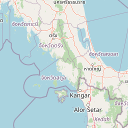
Understand where Ao Phang Nga National Park sits in Thailand through a broader geographic reading of the surrounding landscape, nearby location context, and its mapped position within the national park landscape.

How Ao Phang Nga National Park fits into Thailand

Thailand is a Southeast Asian nation formerly called Siam, located in mainland Southeast Asia. It operates as a unitary parliamentary constitutional monarchy under King Vajiralongkorn. The country borders Myanmar, Laos, Cambodia, and Malaysia, with maritime boundaries involving Vietnam, Indonesia, and India. Thailand has a population of nearly 66 million and covers approximately 513,120 km². Historically, the Sukhothai Kingdom marks the beginning of Thai history, followed by the powerful Ayutthaya Kingdom.

Wider geography shaping Ao Phang Nga National Park in Thailand

Thailand occupies mainland Southeast Asia with borders to Myanmar (west/northwest), Laos (east/northeast), Cambodia (southeast), and Malaysia (south). The country has coastline along the Gulf of Thailand to the southeast and the Andaman Sea to the southwest. The territory covers approximately 513,120 km².

Map view of Ao Phang Nga National Park

Use this park location map to pinpoint Ao Phang Nga National Park in Thailand, understand its exact geographic position, and read its mapped placement within the surrounding landscape more clearly.

Pigeon | © OpenStreetMap contributors

Location context for Ao Phang Nga National Park

Phang Nga Province
Park atlas

Compare diverse marine and coastal protected areas, tracing regional geography and interconnected ecosystems.

Explore Other National Parks and Protected Areas Near Ao Phang Nga National Park
Browse a curated atlas of protected areas surrounding Ao Phang Nga National Park, featuring diverse marine reserves and coastal ecosystems. Explore connected limestone karst landscapes and regional conservation efforts, allowing for geographic comparison beyond a single national park.
National parkPhang Nga Province

Khao Lampi, Hat Thai Mueang National Park: Mountain Rainforest and Andaman Coast Atlas

Explore the mapped geography and protected boundaries.

Delve into Khao Lampi, Hat Thai Mueang National Park, a key protected area within Phang Nga Province, Thailand. This unique national park showcases a striking dichotomy: the lush, waterfall-adorned slopes of the Khao Lampi mountains contrast with the pristine Andaman Sea coastline of Hat Thai Mueang beach, a critical site for sea turtle nesting. The park's mapped landscape encompasses dense tropical rainforest, significant mangrove ecosystems, and important natural terrain, offering a comprehensive view of diverse protected environments for atlas exploration.

Area
72 km²
Established
1986
IUCN
II
Visitors
50.5K annual
National parkPhuket Province

Sirinat National Park: Phuket Province Protected Coastal Landscape and Marine Atlas

Mapped boundaries, beach forests, and sea turtle nesting sites.

Sirinat National Park offers a unique opportunity to explore a protected coastal geography on Phuket Island. This national park preserves critical beach forest ecosystems, extensive shorelines like Hat Mai Khao, vital sea turtle nesting grounds, and surrounding marine environments including coral reefs and mangrove habitats. Its designation as a protected area provides essential context for understanding the natural landscape and its ecological significance within Thailand's regional geography.

Area
90 km²
Established
1981
IUCN
II
Visitors
51.2K annual
National parkPhang Nga Province

Khao Lak, Lam Ru National Park: Protected National Park Landscape and Geography

Explore its mapped boundaries and regional context in Phang Nga Province.

This entry focuses on Khao Lak, Lam Ru National Park, a designated national park offering a distinct protected landscape within Phang Nga Province, Thailand. It provides structured data and map context crucial for understanding its geographic scope and regional significance. Explore the park's mapped boundaries, its role as a protected area, and its contribution to the broader landscape of southern Thailand, fostering a deeper appreciation for its natural geography and atlas-derived insights.

Area
125 km²
Established
1991
IUCN
II
Visitors
72.2K annual
National parkKrabi Province

Khao Phanom Bencha National Park: Protected Mountainous Rainforest and Waterfall Landscapes

Explore Krabi Province's unique protected area and its dramatic geographic features.

Khao Phanom Bencha National Park represents a core protected landscape within Krabi Province, Thailand. Dominated by the imposing Khao Phanom Bencha mountain range, its terrain includes steep, forested slopes and intricate valley systems that give rise to impressive waterfalls. This national park is an essential component of the region's protected natural areas, offering a detailed look at its unique ecosystem and geographic character through mapped landscape context and atlas exploration.

Area
50 km²
Established
1981
IUCN
II
Visitors
17.3K annual
National parkSurat Thani Province

Khao Sok National Park: Protected Landscape Atlas and Geographic Detail

Explore mapped boundaries and regional terrain in Surat Thani Province.

Khao Sok National Park represents a crucial protected landscape within the expansive geography of Surat Thani Province, Thailand. This detailed entry focuses on the park's identity as a national park, emphasizing its mapped boundaries and the surrounding natural terrain. Through structured information and geographic context, users can gain a clear understanding of Khao Sok National Park's place in the atlas, contributing to a more informed approach to landscape discovery.

Area
739 km²
Established
1980
IUCN
II
Visitors
419.5K annual
National parkKrabi Province

Hat Noppharat Thara, Mu Ko Phi Phi National Park: Protected Landscape and Geographic Identity

Explore mapped terrain and protected natural areas in Krabi Province.

Hat Noppharat Thara, Mu Ko Phi Phi National Park stands as a distinct protected natural landscape, offering a unique geographic perspective within Krabi Province. This page delves into its role as a national park, highlighting its mapped boundaries and contribution to the regional atlas. Users can explore the park's specific natural terrain and understand its significance as a conservation area, providing a foundation for broader geographic discovery.

Area
388 km²
Established
1983
IUCN
II
Visitors
1.1M annual
National parkSurat Thani Province

Kaeng Krung National Park: Exploring Protected Area Boundaries and Regional Geography

A National Park within Surat Thani Province's diverse landscapes.

Kaeng Krung National Park is a distinct protected area situated in Surat Thani Province, Thailand. This page provides essential context for understanding the park's geographic significance, its mapped boundaries, and its contribution to the regional protected landscape atlas. Explore the fundamental geographic characteristics that define this important natural reserve and its surrounding terrain.

Area
541 km²
Established
1991
IUCN
II
Visitors
909 annual
National parkThailand

Mu Ko Lanta National Park: Protected National Park and Mapped Landscape in Thailand

Explore its boundaries within Thailand's regional geography.

Mu Ko Lanta National Park is a significant protected area within Thailand, defined by its national park status and distinct geographic features. This page facilitates structured discovery of its mapped landscape and the regional context it occupies. Users can explore its protected-area identity and understand how it fits into the broader atlas of natural landscapes in Southeast Asia, emphasizing geographic specificity and atlas-driven insights.

Area
134 km²
Established
1990
IUCN
II
Visitors
217.4K annual

Common questions about visiting, size, designation, and location context for Ao Phang Nga National Park

Ao Phang Nga National Park FAQs for park facts, access, geography, and protected area context
Find quick answers about Ao Phang Nga National Park, including protected-area facts, park geography, trail and visitor context, and how the park fits into its surrounding country and regional landscape.
MoriAtlas Explorer

Continue Your Protected Areas Search Across the Global Atlas

Deepen your exploration by continuing the structured search for national parks and protected areas worldwide. Utilize the comprehensive filtering capabilities to compare different conservation landscapes and refine your understanding of global park geography. Discover more about the distribution and characteristics of protected natural areas.

Global natural geography