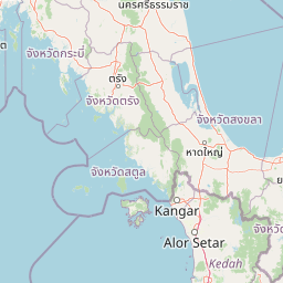
Why Mu Ko Lanta National Park stands out
Mu Ko Lanta National Park is best known for its dramatic mountainous island landscapes that rise steeply from the Andaman Sea, creating a distinctive backdrop of forested slopes and hidden beaches. The park protects significant coral reef systems and marine environments around its scattered islands, making it important for coastal and marine biodiversity. The cultural presence of the Chao Ley sea gypsy community on Ko Lanta Yai distinguishes this park from many other Thai protected areas, as visitors can observe traditional practices including the ceremonial boat drifting rituals performed on full moon nights. The combination of terrestrial mountain forests, mangrove ecosystems, beach vegetation, and coral reef environments within a single protected area creates a compact but ecologically diverse island archipelago that serves both conservation and cultural preservation purposes.
Mu Ko Lanta National Park history and protected-area timeline
Mu Ko Lanta National Park was established on 15 August 1990, formalizing protection for the island archipelago in southern Krabi Province. The establishment of the park reflected growing recognition of the ecological and cultural significance of Thailand's island environments during the late twentieth century. Prior to national park designation, the islands had been subject to varying degrees of informal protection and management. The park's creation came during a period of expansion in Thailand's national park system, which sought to protect representative samples of the country's diverse ecosystems including coastal and marine environments. The region has a longer human history, with the islands serving as home to Chao Ley communities for generations. These sea gypsy groups maintained their traditional maritime lifestyle and cultural practices on Ko Lanta Yai well before formal protected area status was established, and their continued presence has shaped both the social landscape and the management approach for the park. The establishment also reflected increasing tourism pressure on Thailand's island destinations during the 1980s and 1990s, as the government sought to balance development with environmental protection in rapidly growing coastal areas.
Mu Ko Lanta National Park landscape and geographic character
The landscape of Mu Ko Lanta National Park is defined by its steep, mountainous terrain rising abruptly from the Andaman Sea. The islands feature dramatic topography with most areas experiencing slopes exceeding 35 degrees, and some sections in the central portions of the main islands having slopes greater than 50 degrees. The highest point reaches approximately 488 meters above sea level, creating peaks that are visible from surrounding waters and contribute to the islands' distinctive silhouettes. The mountainous core of the larger islands drops sharply to narrow coastal plains only in beach areas, particularly along the southern portions of Ko Lanta Yai. Between the steep interior slopes and the shoreline, visitors encounter a transition through tropical forest ecosystems before reaching the beach zones and marine environments. The smaller islands in the archipelago tend to have less dramatic topography but still feature varied terrain including rocky shores, sandy beaches, and surrounding coral reef platforms. The marine component of the park includes shallow coral reef areas, underwater caves, and seagrass beds that extend from the island shorelines into deeper waters. This combination of towering island peaks, forest-clothed slopes, and surrounding marine environments creates a landscape of considerable visual diversity within a relatively compact geographic area.
Mu Ko Lanta National Park ecosystems, habitats, and plant life
The ecological character of Mu Ko Lanta National Park reflects its position in the tropical coastal zone of the Andaman Sea, supporting multiple distinct habitat types within its island archipelago. Tropical rainforest covers substantial portions of Ko Lanta Yai, extending across approximately 19.42 square kilometres with canopy trees reaching heights of 15 to 25 meters. The rainforest supports species such as Hopea ferrea, Dipterocarpus turbinatus, and Lagerstroemia floribunda, representing the typical dipterocarp forest composition found throughout Thailand's southern regions. Mangrove forests occur on several smaller islands including Ko Ngu, Ko Mai Ngam, and Ko Mai Ngam Tai, where species such as Avicennia alba, Rhizophora apiculata, and Rhizophora mucronata create structured wetland ecosystems between land and sea. Beach forest zones appear on islands like Ko Ngai, featuring species adapted to sandy, saline conditions including Terminalia catappa, Millettia pinnata, and Ipomoea pes-caprae. The marine environment supports coral reef communities with species such as staghorn coral and Fungia fungites, providing habitat for diverse reef fish and invertebrates. This mosaic of forest types, from lowland rainforest through mangrove to beach vegetation, creates ecological diversity within a relatively limited terrestrial area.
Mu Ko Lanta National Park wildlife and species highlights
The wildlife of Mu Ko Lanta National Park reflects the park's diverse island habitats, though the fauna community is shaped by the islands' relatively isolated nature within the marine environment. Mammal diversity is limited by the island setting, with bats representing the primary small mammal group present today. Historical records indicate that larger mammals including deer, tigers, and barking deer formerly inhabited the islands but are no longer present in significant populations. The bird community includes species adapted to island and coastal environments such as the brahminy kite, bridled tern, and emerald dove. Reptile populations include the asian water monitor, reticulated python, and various cobra species, representing the typical reptile fauna of Thailand's forested areas. Amphibians such as giant mountain frogs, ornate froglets, and common tree frogs inhabit the freshwater and forest floor environments. The marine and freshwater fish communities include both resident and migratory species, with coral reef fish representing an important component of the park's aquatic biodiversity. The coral reef environments support invertebrate species including various coral types that form the structural foundation of the reef ecosystem.
Mu Ko Lanta National Park conservation status and protection priorities
Mu Ko Lanta National Park operates as an IUCN Category II protected area, reflecting its designation as a national park focused on ecosystem conservation and visitor recreation. The park's conservation significance stems from its protection of representative island and marine ecosystems in Thailand's southern coastal region. The park protects terrestrial forest habitats that would otherwise face pressure from development and agriculture on Thailand's increasingly developed coastlines. The mangrove forests within the park serve important ecological functions including coastal stabilization, water filtration, and provision of nursery habitat for marine species. Coral reef protection contributes to marine biodiversity preservation in the Andaman Sea region, an area that faces various pressures from tourism, fishing, and coastal development. The park's management approach must balance conservation objectives with the presence of resident communities on the larger islands, particularly the Chao Ley population on Ko Lanta Yai. Seasonal closures of some smaller islands during the rainy season from mid-May through October help reduce visitor impact during periods of higher environmental sensitivity.
Mu Ko Lanta National Park cultural meaning and human context
The cultural landscape of Mu Ko Lanta National Park is shaped significantly by the presence of the Chao Ley community, a group traditionally known as sea gypsies or urchin people who have inhabited the islands for generations. A clan of Chao Ley continues to reside on Ko Lanta Yai, maintaining many of their ancient customs and ceremonial practices that distinguish the cultural character of the park. Of particular note are the ceremonial boat drifting rituals performed on full moon nights during the sixth and eleventh months of the traditional Thai calendar, ceremonies intended to bring good luck and prosperity. These practices represent living cultural traditions that predate the establishment of the national park and continue to be performed by community members today. The historical toponymy of the islands reflects multiple cultural influences, with the original Malay name Pulao Satak meaning Long Beach Island, and the Thai name Lan Ta deriving from a term meaning a million eyes, possibly reflecting the later settlement of both Buddhist and Muslim Thai communities on the islands. The park thus represents not only ecological conservation but also the preservation of a culturally distinct community whose relationship with the marine environment defines much of the region's character.
Top sights and standout views in Mu Ko Lanta National Park
The dramatic mountainous terrain of Ko Lanta Yai, rising steeply to 488 meters with forest-covered slopes visible from the Andaman Sea, represents the park's most striking terrestrial landscape. The traditional Chao Ley sea gypsy community maintaining ceremonial practices on Ko Lanta Yai provides cultural context rarely found in Thailand's other national parks. The variety of forest ecosystems within a compact island setting, from tropical rainforest through mangrove to beach forest, creates ecological diversity unusual for a marine-focused protected area. Coral reef environments surrounding the islands support marine biodiversity and provide underwater exploration opportunities. The park's seasonal character, with some islands closed during the May-to-October rainy season, influences the experience of visiting and adds to the sense of environmental respect embedded in park management. The islands of Ko Ngai, Ko Mai Ngam, Mu Ko Rok, and other smaller islands each offer distinct landscapes and atmospheres within the broader park mosaic.
Best time to visit Mu Ko Lanta National Park
The optimal time to visit Mu Ko Lanta National Park aligns with Thailand's dry season, typically from November through April, when rainfall is minimal and visitor access to the islands is most reliable. The climate data shows February averages only about 1.6 rainy days compared to September's 21.6 days, making the winter and spring months the most stable period for park exploration. During the dry season, all islands within the park remain accessible to visitors, allowing full exploration of the archipelago's various terrestrial and marine environments. The wet season from mid-May through October brings increased rainfall, with September typically recording the highest monthly precipitation at 391.4 millimeters, and some of the smaller outer islands are closed to visitors for environmental protection. Visiting during the dry season also provides more comfortable conditions for hiking the mountainous terrain and for underwater activities such as snorkeling and diving around the coral reefs. The transitional periods at the start and end of the dry season often offer good conditions with fewer crowds than the peak December-to-February tourist season.