

Mori Atlas logo
National parkHat Noppharat Thara–Mu Ko Phi Phi National Park

Discover mapped park boundaries and natural terrain within Krabi Province, Thailand.

Hat Noppharat Thara–Mu Ko Phi Phi National Park: Protected Landscape and Geographic Context

Hat Noppharat Thara–Mu Ko Phi Phi National Park represents a significant protected natural landscape situated in Thailand's Krabi Province. As a designated national park, it offers critical insight into the region's geography and mapped protected areas. This page provides a focused exploration of the park's identity, helping users understand its place within the national atlas through its geographic features and protected land context.

Marine National ParkCoral ReefsLimestone IslandsAndaman SeaImportant Bird AreaIsland Group

Hat Noppharat Thara–Mu Ko Phi Phi National Park

National park

Park overview

Structured park overview, official facts, and landscape profile for Hat Noppharat Thara, Mu Ko Phi Phi National Park

Hat Noppharat Thara, Mu Ko Phi Phi National Park park facts, protected area profile, and essential visitor context
Review the core facts for Hat Noppharat Thara, Mu Ko Phi Phi National Park, including designation, size, terrain, visitor scale, habitats, and operating context in one park-focused overview.

About Hat Noppharat Thara, Mu Ko Phi Phi National Park

Hat Noppharat Thara–Mu Ko Phi Phi National Park represents one of Thailand's premier marine protected areas, covering approximately 388 square kilometers along the scenic coastline of Krabi Province in the Andaman Sea region. The park encompasses a diverse collection of marine environments, from shallow coral reefs to deeper offshore waters, interspersed with limestone islands and hidden lagoons that have become emblematic of southern Thai coastal scenery. The Phi Phi Islands, particularly Ko Phi Phi Don with its twin bays and Ko Phi Phi Le with its famous Maya Bay, form the most recognizable portion of the park and attract the majority of visitors. These islands feature dramatic karst limestone formations rising steeply from the sea, creating iconic landscapes of vertical cliffs, hidden caves, and pristine beaches. The park extends beyond the islands to include mainland coastal areas near Ao Nang and the Noppharat Thara beach area, establishing a contiguous marine protection zone that preserves both island and mainland coastal ecosystems. The park's establishment in 1983 reflected growing recognition of the ecological and economic value of Thailand's marine coastal environments, and today the area plays a crucial role in protecting coral reef habitats, marine species diversity, and significant bird populations while also supporting sustainable tourism that contributes substantially to the local and regional economy.

Quick facts and research context for Hat Noppharat Thara, Mu Ko Phi Phi National Park

This marine national park occupies roughly 388 square kilometers along the Krabi Province coastline in southern Thailand, encompassing both mainland shoreline sections and offshore islands including the Phi Phi archipelago. Established in 1983 under Thai national park legislation, the area is managed by the Department of National Park, Wildlife and Plant Conservation. The park experiences a tropical monsoon climate with a rainy season from May through December and a hot dry season from January to April. Annual rainfall averages around 2,231 millimeters with temperatures ranging from 17 to 37 degrees Celsius. The park has been recognized as an Important Bird Area by BirdLife International due to populations of pale-capped pigeons and Christmas Island frigatebirds. Visitor numbers exceed one million annually, making it one of Thailand's most heavily visited marine protected areas.

Park context

Deeper park guide and search-rich context for Hat Noppharat Thara, Mu Ko Phi Phi National Park

Hat Noppharat Thara, Mu Ko Phi Phi National Park history, landscape, wildlife, and travel context
Explore Hat Noppharat Thara, Mu Ko Phi Phi National Park through its history, landscape character, ecosystems, wildlife, conservation priorities, cultural context, and seasonal travel timing in a structured park guide built for atlas discovery and search intent.

Why Hat Noppharat Thara, Mu Ko Phi Phi National Park stands out

Hat Noppharat Thara, Mu Ko Phi Phi National Park is best known for its stunning marine environment that includes the iconic Phi Phi Islands, particularly Ko Phi Phi Don and Ko Phi Phi Le. The park features excellent coral reef systems, the famous Maya Bay (known from the movie The Beach), dramatic limestone cliffs rising from turquoise waters, and the unique Pileh Lagoon. Above water, the Fossil Shell Beach at Ban Laem Pho stands as one of the world's few shell fossil cemeteries, with limestone slabs containing millions of fossilized freshwater snail shells dating back over 70 million years to the Tertiary period. The park's designation as an Important Bird Area reflects its significance for rare species including the pale-capped pigeon and Christmas Island frigatebird.

Hat Noppharat Thara, Mu Ko Phi Phi National Park history and protected-area timeline

The national park was officially established in 1983 as part of Thailand's expanding network of protected areas during a period of increased environmental consciousness and recognition of the need to preserve coastal and marine ecosystems. The creation of the park came in response to growing pressures on the Phi Phi Islands and surrounding marine environment from expanding tourism and development along the Andaman coast. The park was designated under Thai national park legislation and classified as an IUCN Category II protected area, reflecting its primary objective of preserving natural ecosystems while allowing for controlled sustainable use. Over the subsequent decades, the park has faced ongoing management challenges related to the high volume of visitors, particularly to the Phi Phi Islands, which saw dramatic increases in tourism activity following the success of the film The Beach in 2000. Management efforts have focused on balancing conservation objectives with the economic realities of tourism-dependent local communities. The Department of National Park, Wildlife and Plant Conservation has implemented various regulations and zoning systems to protect sensitive reef areas while maintaining visitor access to popular destinations.

Hat Noppharat Thara, Mu Ko Phi Phi National Park landscape and geographic character

The landscape of Hat Noppharat Thara–Mu Ko Phi Phi National Park is defined by its dramatic karst limestone geology, a characteristic feature of the Phang Nga coast and Andaman Sea region. Towering limestone cliffs rise abruptly from the sea, creating a succession of vertical faces, hidden sea caves, and detached islands that form one of Thailand's most photographed coastlines. The Phi Phi Islands showcase this limestone terrain at its most spectacular, with Ko Phi Phi Le's massive cliffs dropping directly into deep turquoise waters and enclosing secluded beaches like Maya Bay and Pileh Lagoon. The park's islands and mainland areas feature beaches ranging from long stretches of sand to rocky terraces, with the Fossil Shell Beach at Ban Laem Pho presenting a particularly unusual coastal formation where ancient shell fossils are visible embedded in limestone slab layers that stretch for approximately two kilometers along the shoreline. The marine landscape beneath the water surface includes coral reef platforms, seagrass beds, and varying depths that support different ecological communities. The overall visual character combines the deep greens of vegetation on limestone slopes with the brilliant blues and greens of the Andaman Sea, punctuated by the white sails of traditional long-tail boats that navigate these waters.

Hat Noppharat Thara, Mu Ko Phi Phi National Park ecosystems, habitats, and plant life

The marine nature of the park centers on its coral reef ecosystems, which support high biodiversity despite regional challenges from bleaching events and development pressures. The park's waters contain various reef formations including fringing reefs around islands, patch reefs in shallower areas, and deeper slope reefs that descend into more offshore zones. These coral communities provide habitat for numerous fish species, invertebrates, and other marine organisms that form the base of the park's ecological value. The terrestrial and nearshore environments support important bird populations, with the park's designation as an Important Bird Area by BirdLife International recognizing its global significance for two particular species. The pale-capped pigeon and Christmas Island frigatebird find suitable habitat within the park's islands and coastal areas, with the rocky cliffs and forested island slopes providing nesting and roosting sites. The Fossil Shell Beach represents a unique geological natural phenomenon where the preserved remains of ancient freshwater snails from the Tertiary period, over 70 million years old, have been cemented into limestone slabs that now form a distinctive terrace beach formation.

Hat Noppharat Thara, Mu Ko Phi Phi National Park wildlife and species highlights

The wildlife of Hat Noppharat Thara–Mu Ko Phi Phi National Park is most notable for its bird populations and marine species. As an Important Bird Area designated by BirdLife International, the park supports significant populations of pale-capped pigeons, a species that inhabits forest areas on the islands and mainland portions of the park, and Christmas Island frigatebirds that can be observed soaring above the islands and coastal waters. These frigatebirds are particularly associated with the marine environment and island colonies where they nest. The marine waters contain diverse fish communities associated with coral reefs, including numerous reef fish species that inhabit the complex structures provided by living coral. While the park is not known for large terrestrial mammal populations, the islands provide habitat for various smaller species and the surrounding seas support marine life including various fish, crustaceans, and mollusks that inhabit the reef systems. The high visitor numbers have created management challenges for wildlife, with ongoing efforts needed to ensure that tourism activities do not compromise the ecological integrity that supports these wildlife populations.

Hat Noppharat Thara, Mu Ko Phi Phi National Park conservation status and protection priorities

The conservation significance of Hat Noppharat Thara–Mu Ko Phi Phi National Park derives from its role as a protected marine environment in a region facing substantial development and tourism pressure. The park's IUCN Category II designation reflects its primary conservation objective of ecosystem preservation while allowing for sustainable use. Its coral reef systems, while facing challenges from environmental stresses including warming events and physical damage from anchoring and activity, remain important for regional marine biodiversity. The Important Bird Area designation highlights the park's global significance for species conservation, particularly for the pale-capped pigeon and Christmas Island frigatebird. Management by Thailand's Department of National Park, Wildlife and Plant Conservation includes visitor management, regulatory enforcement, and monitoring efforts aimed at maintaining the park's ecological values. The high visitor numbers, exceeding one million annually, create both challenges and justifications for conservation investment, as tourism revenue supports park management while visitor activity requires careful management to minimize ecological impacts on sensitive reef and island habitats.

Hat Noppharat Thara, Mu Ko Phi Phi National Park cultural meaning and human context

The cultural context of the park is closely tied to the maritime traditions of Krabi Province and the broader southern Thai coastal culture. The name Hat Noppharat Thara translates from Thai as Noppharat Thara Beach, reflecting the park's inclusion of significant coastal areas along the mainland. The designation Mu Ko Phi Phi refers to the Phi Phi Islands, which have been part of the local maritime cultural landscape for generations of fishing communities. The Fossil Shell Beach holds cultural as well as geological significance as a natural landmark that has attracted attention and local interest over time. The islands and coastline have historical connections to the sea-based communities that have inhabited this region long before the development of modern tourism. Today, the park exists at the intersection of traditional coastal livelihoods, conservation objectives, and tourism-driven economic change, with local fishing communities, tourism operators, and conservation managers all having stake in how the park's resources are used and preserved.

Top sights and standout views in Hat Noppharat Thara, Mu Ko Phi Phi National Park

The park's highlights include the world-renowned Phi Phi Islands, particularly the dramatic scenery of Ko Phi Phi Le with its Maya Bay and Pileh Lagoon, and the twin-bay landscape of Ko Phi Phi Don. The Fossil Shell Beach at Ban Laem Pho offers a unique geological experience with 70-million-year-old fossilized shells visible in limestone formations stretching along a two-kilometer shoreline, one of the world's few shell fossil cemeteries. The park's coral reefs provide excellent snorkeling and diving opportunities, while the limestone cliffs create scenic landscapes that have become iconic representations of Thai coastal beauty. The Important Bird Area designation highlights opportunities to observe rare species including pale-capped pigeons and Christmas Island frigatebirds. The park also preserves traditional maritime landscapes with long-tail boats operating from coastal piers, maintaining connections to the area's fishing heritage.

Best time to visit Hat Noppharat Thara, Mu Ko Phi Phi National Park

The best time to visit Hat Noppharat Thara–Mu Ko Phi Phi National Park is during the dry season from January through April, when weather conditions are most stable and sea conditions are typically calmest for island visits and water activities. During this hot season, temperatures range from the upper twenties to mid-thirties Celsius, and rainfall is minimal, making it the peak tourist period. The rainy season from May through December brings more frequent showers and rougher seas, though these months can still offer good experiences with fewer crowds and greener landscapes. The park's location on the Andaman Sea means that the southwest monsoon influences conditions from approximately May to October, while the northeast monsoon brings more stable weather from November to February. Visitors seeking optimal reef conditions should note that coral health can vary with seasonal temperature changes, and the park experiences high visitor numbers throughout the year, particularly during holiday periods and international tourism peaks.
Park location guide

Geography guide, regional context, and park location map for Hat Noppharat Thara, Mu Ko Phi Phi National Park

Hat Noppharat Thara, Mu Ko Phi Phi National Park park geography, regions, and map view in Thailand
Understand where Hat Noppharat Thara, Mu Ko Phi Phi National Park sits in Thailand through a broader geographic reading of the surrounding landscape, nearby location context, and its mapped position within the national park landscape.

How Hat Noppharat Thara, Mu Ko Phi Phi National Park fits into Thailand

Thailand is a Southeast Asian nation formerly called Siam, located in mainland Southeast Asia. It operates as a unitary parliamentary constitutional monarchy under King Vajiralongkorn. The country borders Myanmar, Laos, Cambodia, and Malaysia, with maritime boundaries involving Vietnam, Indonesia, and India. Thailand has a population of nearly 66 million and covers approximately 513,120 km². Historically, the Sukhothai Kingdom marks the beginning of Thai history, followed by the powerful Ayutthaya Kingdom.

Wider geography shaping Hat Noppharat Thara, Mu Ko Phi Phi National Park in Thailand

Thailand occupies mainland Southeast Asia with borders to Myanmar (west/northwest), Laos (east/northeast), Cambodia (southeast), and Malaysia (south). The country has coastline along the Gulf of Thailand to the southeast and the Andaman Sea to the southwest. The territory covers approximately 513,120 km².

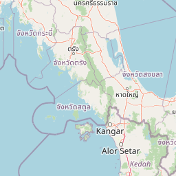
Map view of Hat Noppharat Thara, Mu Ko Phi Phi National Park

Use this park location map to pinpoint Hat Noppharat Thara, Mu Ko Phi Phi National Park in Thailand, understand its exact geographic position, and read its mapped placement within the surrounding landscape more clearly.

Pigeon | © OpenStreetMap contributors

Location context for Hat Noppharat Thara, Mu Ko Phi Phi National Park

Krabi Province
Park atlas

Compare marine and karst protected landscapes across the surrounding Andaman Sea region.

Discover Nearby National Parks and Protected Areas Beyond Hat Noppharat Thara–Mu Ko Phi Phi National Park
Discover additional national parks and protected areas across the Andaman Sea, expanding your view of Thailand's coastal geography and diverse marine conservation landscapes. Uncover comparable karst formations, island groups, and rich coral reef systems that define this tropical region, tracing the protected natural heritage of southern Thailand.
National parkThailand

Mu Ko Lanta National Park: Protected National Park and Mapped Landscape in Thailand

Explore its boundaries within Thailand's regional geography.

Mu Ko Lanta National Park is a significant protected area within Thailand, defined by its national park status and distinct geographic features. This page facilitates structured discovery of its mapped landscape and the regional context it occupies. Users can explore its protected-area identity and understand how it fits into the broader atlas of natural landscapes in Southeast Asia, emphasizing geographic specificity and atlas-driven insights.

Area
134 km²
Established
1990
IUCN
II
Visitors
217.4K annual
National parkKrabi Province

Khao Phanom Bencha National Park: Protected Mountainous Rainforest and Waterfall Landscapes

Explore Krabi Province's unique protected area and its dramatic geographic features.

Khao Phanom Bencha National Park represents a core protected landscape within Krabi Province, Thailand. Dominated by the imposing Khao Phanom Bencha mountain range, its terrain includes steep, forested slopes and intricate valley systems that give rise to impressive waterfalls. This national park is an essential component of the region's protected natural areas, offering a detailed look at its unique ecosystem and geographic character through mapped landscape context and atlas exploration.

Area
50 km²
Established
1981
IUCN
II
Visitors
17.3K annual
National parkPhuket Province

Sirinat National Park: Phuket Province Protected Coastal Landscape and Marine Atlas

Mapped boundaries, beach forests, and sea turtle nesting sites.

Sirinat National Park offers a unique opportunity to explore a protected coastal geography on Phuket Island. This national park preserves critical beach forest ecosystems, extensive shorelines like Hat Mai Khao, vital sea turtle nesting grounds, and surrounding marine environments including coral reefs and mangrove habitats. Its designation as a protected area provides essential context for understanding the natural landscape and its ecological significance within Thailand's regional geography.

Area
90 km²
Established
1981
IUCN
II
Visitors
51.2K annual
National parkTrang Province

Hat Chao Mai National Park: National Park Protected Landscape and Geographic Context

Explore Trang Province's mapped protected areas and natural terrain.

Hat Chao Mai National Park serves as a focal point for understanding protected lands in Trang Province, Thailand. This entry offers insights into the park's specific geographic attributes and its designation as a national park. Users can explore the mapped boundaries and the surrounding regional geography, gaining a clear picture of this protected landscape within the MoriAtlas geographic framework. Understanding Hat Chao Mai National Park provides essential context for regional park exploration and mapped conservation areas.

Area
231 km²
Established
1981
IUCN
II
Visitors
83K annual
National parkThailand

Ao Phang Nga National Park: A Protected National Park in Thailand's Geographic Atlas

Explore the mapped landscape and protected area identity.

Ao Phang Nga National Park offers a distinct protected landscape within Thailand, serving as a key entry in the national park atlas. This page focuses on delineating its geographic boundaries and understanding its specific characteristics as a national park. Users can discover the mapped context and regional setting, providing valuable insights into Thailand's protected natural areas and their conservation significance.

Area
400 km²
Established
1981
IUCN
II
Visitors
999K annual
National parkPhang Nga Province

Khao Lampi, Hat Thai Mueang National Park: Mountain Rainforest and Andaman Coast Atlas

Explore the mapped geography and protected boundaries.

Delve into Khao Lampi, Hat Thai Mueang National Park, a key protected area within Phang Nga Province, Thailand. This unique national park showcases a striking dichotomy: the lush, waterfall-adorned slopes of the Khao Lampi mountains contrast with the pristine Andaman Sea coastline of Hat Thai Mueang beach, a critical site for sea turtle nesting. The park's mapped landscape encompasses dense tropical rainforest, significant mangrove ecosystems, and important natural terrain, offering a comprehensive view of diverse protected environments for atlas exploration.

Area
72 km²
Established
1986
IUCN
II
Visitors
50.5K annual
National parkThailand

Khao Pu, Khao Ya National Park: Explore Protected Boundaries and Thailand Geography

A key national park for understanding regional landscape context.

Khao Pu, Khao Ya National Park stands as a vital protected area in Thailand, offering rich geographic details for atlas exploration. This page details its specific mapped boundaries and its identity as a national park, providing essential context for understanding natural landscapes within Southeast Asia. Users can gain insights into its regional significance and its contribution to the country's protected land network.

Area
694 km²
Established
1982
IUCN
II
Visitors
167.3K annual
National parkPhang Nga Province

Khao Lak, Lam Ru National Park: Protected National Park Landscape and Geography

Explore its mapped boundaries and regional context in Phang Nga Province.

This entry focuses on Khao Lak, Lam Ru National Park, a designated national park offering a distinct protected landscape within Phang Nga Province, Thailand. It provides structured data and map context crucial for understanding its geographic scope and regional significance. Explore the park's mapped boundaries, its role as a protected area, and its contribution to the broader landscape of southern Thailand, fostering a deeper appreciation for its natural geography and atlas-derived insights.

Area
125 km²
Established
1991
IUCN
II
Visitors
72.2K annual

Common questions about visiting, size, designation, and location context for Hat Noppharat Thara, Mu Ko Phi Phi National Park

Hat Noppharat Thara, Mu Ko Phi Phi National Park FAQs for park facts, access, geography, and protected area context
Find quick answers about Hat Noppharat Thara, Mu Ko Phi Phi National Park, including protected-area facts, park geography, trail and visitor context, and how the park fits into its surrounding country and regional landscape.
MoriAtlas Explorer

Continue Your Protected Areas Search Across the Global Atlas

Deepen your exploration by continuing the structured search for national parks and protected areas worldwide. Utilize the comprehensive filtering capabilities to compare different conservation landscapes and refine your understanding of global park geography. Discover more about the distribution and characteristics of protected natural areas.

Global natural geography