

Mori Atlas logo
National parkLiuwa Plain National Park

Discover the mapped protected landscape and regional geography of Liuwa Plain National Park.

Liuwa Plain National Park: A National Park in Western Province, Zambia

Liuwa Plain National Park stands as a significant protected area within the geographic expanse of Zambia's Western Province. This dedicated national park offers a lens for understanding regional landscape context and the distribution of conservation lands. Users can explore its mapped boundaries and natural terrain, gaining insight into its unique position within the broader atlas of protected areas. The park represents a vital component for structured geographic discovery, providing detailed insights into its mapped environment and regional setting for focused atlas exploration.

National ParkGrassland EcosystemWildlife MigrationBig FiveLion ConservationBirdwatching

Liuwa Plain National Park

National park

Park overview

Structured park overview, official facts, and landscape profile for Liuwa Plain National Park

Liuwa Plain National Park park facts, protected area profile, and essential visitor context
Review the core facts for Liuwa Plain National Park, including designation, size, terrain, visitor scale, habitats, and operating context in one park-focused overview.

About Liuwa Plain National Park

Liuwa Plain National Park represents one of Zambia's most remote and ecologically significant protected areas, situated in the flat, low-lying landscape of the Barotse Floodplain in Western Province. The park's defining feature is its expansive grassland ecosystem, a vast savanna environment that supports extraordinary concentrations of wildlife despite decades of conservation challenges. The name "Liuwa" derives directly from the local language, where it simply means "plain," capturing the essence of this extensive flat landscape that stretches as far as the eye can see. The park's ecological significance extends beyond its mammal populations to include more than 330 recorded bird species, making it an important destination for birdwatchers interested in African savanna and waterbird species. The management partnership between African Parks, the Zambian government, and the Barotse Royal Establishment represents an innovative approach to conservation that integrates traditional governance structures with modern wildlife management practices. The park's isolation has historically limited tourism development, though recent investments in infrastructure including the King Lewanika Lodge have aimed to make this wilderness more accessible to visitors seeking an off-the-beaten-path safari experience.

Quick facts and research context for Liuwa Plain National Park

Liuwa Plain National Park occupies a significant landscape within Zambia's Western Province, situated in the Barotse Floodplain region near the district capital of Kalabo. The park's grassland ecosystem supports remarkable wildlife populations, most notably the annual blue wildebeest migration numbering in the tens of thousands, which represents Africa's second-largest such movement. The protected area was formally established in 1972 following earlier designation as a royal hunting ground by Litunga Lubosi Lewanika in the 1880s. The park's location within the floodplain system creates seasonal ecological dynamics, with the grasslands providing critical grazing habitat for large herds of wildebeest, zebra, and other grazers, while the river systems support diverse waterbird communities. The park has gained international recognition through conservation efforts to restore predator populations, particularly the reintroduction of lions following the decline of the famous resident lioness Lady Liuwa.

Park context

Deeper park guide and search-rich context for Liuwa Plain National Park

Liuwa Plain National Park history, landscape, wildlife, and travel context
Explore Liuwa Plain National Park through its history, landscape character, ecosystems, wildlife, conservation priorities, cultural context, and seasonal travel timing in a structured park guide built for atlas discovery and search intent.

Why Liuwa Plain National Park stands out

Liuwa Plain is most renowned for its spectacular blue wildebeest migration, the second-largest in Africa, with tens of thousands of animals crossing the grasslands in a dramatic annual spectacle. The park is also famous for Lady Liuwa, a lone lioness who became the subject of a National Geographic documentary and came to symbolize the park's conservation journey after all other lions were eradicated during the 1990s. The park's location within the Barotse Floodplain gives it a distinctive character among Zambia's protected areas, with its vast open grasslands, seasonal flooding patterns, and rich birdlife including endangered species like the wattled crane. The reintroduction of African wild dogs in 2022 further reinforces the park's significance as a predator conservation site.

Liuwa Plain National Park history and protected-area timeline

The history of Liuwa Plain is deeply intertwined with the Lozi people and their traditional leadership. The area was originally the private hunting ground of Lubosi Lewanika, who served as Litunga (king or paramount chief) of the Lozi people in Barotseland from 1878 until his death in 1916. In the early 1880s, Lubosi Lewanika formally designated Liuwa Plain as a protected area, making it one of Africa's earliest recognized wildlife conservation zones. Following Zambia's independence, the area was officially designated as a national park in 1972 when the government took over management. However, the park faced significant challenges during the late 20th century, with increased poaching and human pressure leading to dramatic wildlife population declines. By the early 2000s, many large mammal species had been locally extirpated or drastically reduced. The nonprofit conservation organization African Parks assumed management responsibility in 2003, partnering with the Department of National Parks and Wildlife and the Barotse Royal Establishment. This partnership has focused on restoring wildlife populations, anti-poaching efforts, and developing sustainable tourism. The story of Lady Liuwa, the last remaining lion in the park, became a symbol of both the park's struggles and its eventual recovery, documented in the National Geographic film "The Last Lioness" before her death in 2017.

Liuwa Plain National Park landscape and geographic character

The landscape of Liuwa Plain is characterized by vast, flat grassland terrain situated within the Barotse Floodplain system of western Zambia. The main plain measures approximately 72 kilometers in length and 32 kilometers in width, creating an extensive open savanna environment that is typical of southern Africa's floodplain ecosystems. The terrain is bounded to the north by the Luambimba River and to the south by the Luanginga River, both of which contribute to the seasonal flooding patterns that influence the grassland's ecology. Scattered across the plain are clusters of raffia palms and woodland patches, typically growing on slightly elevated areas that avoid seasonal inundation. The woodland areas contain species such as Baikiaea plurijuga, Guibourtia coleosperma, and Terminalia sericea, creating a diverse habitat structure within the broader grassland matrix. The flat nature of the landscape allows for unobstructed views across the savanna, particularly spectacular during the wildebeest migration when thousands of animals can be observed moving across the plains. The overall topography remains consistently low-elevation, reflecting the park's position within the extensive floodplain system that dominates much of Zambia's Western Province.

Liuwa Plain National Park ecosystems, habitats, and plant life

The nature of Liuwa Plain revolves around its grassland ecosystem within the Barotse Floodplain, a system that experiences seasonal flooding and creates dynamic ecological conditions throughout the year. The grasslands support specialized vegetation adapted to the flood regime, with species like Echinochloa stagnina and Vossia cuspidata providing critical grazing for large herbivore populations. The park lies within a broader mosaic of floodplain, woodland, and swamp environments that support remarkable biodiversity despite the relatively flat terrain. The seasonal nature of the flooding creates a rhythm of ecological productivity, with the grasslands offering abundant forage during the dry season when flood waters recede, and providing refuge for wildlife during the wet season when higher ground becomes limited. The scattered woodlands and raffia palm stands add structural diversity to the landscape, providing shelter and browsing opportunities for different species. The river systems that bound the park create additional habitat diversity, supporting riparian vegetation and serving as water sources for wildlife throughout the year.

Liuwa Plain National Park wildlife and species highlights

Liuwa Plain supports a diverse mammalian fauna, most famously known for its massive blue wildebeest herds that participate in Africa's second-largest annual migration, with tens of thousands of animals moving across the plains in search of fresh grazing. The park's mammal community includes numerous antelope species such as common eland, common tsessebe, oribi, red lechwe, reedbuck, and roan antelope, alongside substantial populations of zebra and buffalo. The predator community includes cheetah, leopard, lion, spotted hyena, and African wild dogs, representing a complete suite of large carnivores appropriate for the ecosystem. The park's most famous resident was Lady Liuwa, a lioness who became the lone surviving member of the park's lion population following widespread hunting and poaching in the 1990s. Her story, documented in a National Geographic film, brought international attention to the park's conservation needs and spurred successful reintroduction efforts that have since established a small pride. The bird fauna is exceptionally diverse with more than 330 species recorded, including impressive concentrations of waterbirds such as various stork species, pelicans, cranes including the endangered wattled crane and grey crowned crane, and numerous raptors like the martial eagle, bateleur, and Pel's fishing owl.

Liuwa Plain National Park conservation status and protection priorities

Liuwa Plain represents a significant conservation success story in southern Africa, having recovered dramatically from near-collapse during the 1990s and early 2000s. The park was designated as a Lion Conservation Unit in 2005, recognizing its importance for apex predator conservation. During the 1990s, virtually all lions were eradicated from the park due to poaching and trophy hunting, leaving only the solitary Lady Liuwa as the last remaining individual. African Parks implemented an ambitious lion reintroduction program that brought in additional lions from Kafue National Park, successfully establishing a breeding pride that numbered approximately 16 individuals by 2022. Similarly, the African wild dog population was restored through the translocation of 11 individuals from South Africa and Kafue National Park in late 2021 and early 2022. Large mammal populations that had declined severely, including buffalo and eland, have been reintroduced and have stabilized. The park's management model integrating the Barotse Royal Establishment reflects recognition of traditional governance structures in conservation, and local community engagement has improved as a result of the restored connection between the protected area and the Litunga.

Liuwa Plain National Park cultural meaning and human context

Liuwa Plain holds deep cultural significance for the Lozi people of Barotseland, whose traditional leadership established the area as a protected hunting ground in the early 1880s. The park's name itself comes from the Liuwa language, a dialect of Lozi, reflecting the deep roots of human connection to this landscape. The area was historically the personal hunting reserve of Lubosi Lewanika, the Litunga or king of the Lozi people, who ruled from 1878 to 1916 and recognized the need to protect the wildlife populations from overexploitation. The Barotse Royal Establishment remains a partner in park management, maintaining the traditional authority's involvement in conservation that began over a century ago. According to local folklore, Lady Liuwa was believed to be a reincarnation of Mambeti, a Lozi tribeswoman who lived and died in the park area, creating a spiritual connection between the lioness and the local community. This cultural dimension adds depth to the park's identity beyond its ecological significance.

Top sights and standout views in Liuwa Plain National Park

The annual blue wildebeest migration stands as Liuwa Plain's most spectacular natural event, with tens of thousands of animals crossing the grasslands in a massive circular movement that ranks as Africa's second-largest such phenomenon. The park's lion population recovery, from a single surviving lioness to a small pride, represents a remarkable conservation achievement that has drawn international attention and documentary coverage. The birdlife is exceptional, with more than 330 species including significant populations of wattled cranes, grey crowned cranes, various storks, and numerous raptors. The park's vast, open landscapes offer a distinctive safari experience far removed from more visited destinations, with opportunities to observe wildlife against the backdrop of an expansive savanna environment. The traditional connection between the park and Lozi royalty, dating to the 1880s, provides historical depth to the conservation narrative.

Best time to visit Liuwa Plain National Park

The optimal time to visit Liuwa Plain coincides with the dry season, typically from May through October, when wildlife viewing is most rewarding as animals concentrate around remaining water sources and the vegetation is less dense. The blue wildebeest migration typically occurs during the latter part of the dry season, with large herds often visible from around August through October. The wet season from November to April brings seasonal flooding to parts of the plain, which while creating beautiful landscapes, can limit accessibility and wildlife viewing in some areas. Birdwatching is excellent year-round, though the presence of migratory species and waterbird concentrations varies seasonally. The park's remote location means that visitor numbers remain low regardless of season, offering an uncrowded wilderness experience.

Park location guide

Geography guide, regional context, and park location map for Liuwa Plain National Park

Liuwa Plain National Park park geography, regions, and map view in Zambia
Understand where Liuwa Plain National Park sits in Zambia through a broader geographic reading of the surrounding landscape, nearby location context, and its mapped position within the national park landscape.

How Liuwa Plain National Park fits into Zambia

Zambia is a landlocked nation in Southern Africa with a population of approximately 20 million people. The country is bordered by eight countries and features diverse geography ranging from the Zambezi River to vast plateaus. Lusaka serves as the capital and largest city, while the Copperbelt Province in the north drives much of the economy through copper mining.

Wider geography shaping Liuwa Plain National Park in Zambia

Zambia is located in Southern Africa and is landlocked, bordered by eight countries: Democratic Republic of the Congo to the north, Tanzania to the northeast, Malawi to the east, Mozambique to the southeast, Zimbabwe and Botswana to the south, Namibia to the southwest, and Angola to the west. The country features varied terrain including the Zambezi River plain in the south, plateaus in the central and northern regions, and the Muchinga Mountains in the northeast. Lake Tanganyika forms part of the northern border.

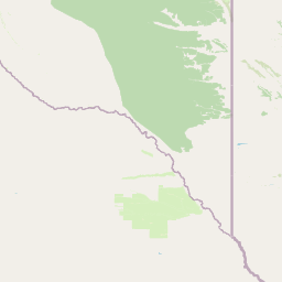
Map view of Liuwa Plain National Park

Use this park location map to pinpoint Liuwa Plain National Park in Zambia, understand its exact geographic position, and read its mapped placement within the surrounding landscape more clearly.

Pigeon | © OpenStreetMap contributors

Location context for Liuwa Plain National Park

Kalabo DistrictWestern Province
Park atlas

Trace the regional spread of protected landscapes and compare diverse conservation areas across western Zambia.

Explore National Parks and Protected Areas Near Liuwa Plain National Park
Discover other national parks and protected areas near Liuwa Plain, tracing similar grassland ecosystems and floodplain environments across western Zambia. Continue your atlas-style exploration to compare conservation landscapes and map the diverse spread of protected wildernesses across the broader region.
National parkAngola

Luengue-Luiana National Park: Angola's Premier Protected Woodland and Floodplain Ecosystem

Mapping crucial habitats for large mammals and avian wildlife.

Luengue-Luiana National Park is a vital protected landscape in southeastern Angola, covering an immense area that transitions from open woodland ecosystems to vast, seasonal floodplain grasslands. As a cornerstone of the Kavango-Zambezi Transfrontier Conservation Area, it facilitates critical wildlife movements and supports significant populations of large mammals. Its geography provides essential habitat, particularly within the extensive wetland wilderness and riparian zones along the Cuando River, making it a significant site for regional biodiversity and atlas exploration.

Area
42,000 km²
Established
2011
IUCN
II
Relief
Lowland
National parkAngola

Mavinga National Park: Protected Landscape Identity and Geographic Mapping in Angola

Explore mapped boundaries and regional context of this national park.

Mavinga National Park stands as a designated protected area within Angola, offering insights into the nation's natural landscapes and conservation efforts. This entry details the park's geographic footprint and its role as a national park. It provides users with essential map-based discovery tools to understand the park's setting, its physical geography, and its significance as a protected natural landscape in southern Africa.

Area
46,076 km²
Established
2011
IUCN
II
Relief
Lowland
National parkMoxico Leste Province

Cameia National Park: Unique Zambezi Basin Wetlands and Miombo Woodlands in Angola

Explore the mapped geography of Angola's sole Zambezi basin ecological sample.

Cameia National Park is a significant protected area in Moxico Leste Province, Angola, distinguished by its status as the country's only representation of Zambezi River basin ecosystems. The park features extensive seasonally inundated plains and characteristic miombo woodlands, offering a unique mosaic of wetland and forest landscapes. Understanding its geographic setting, hydrological connections to the Chifumage, Lumege, and Luena rivers, and its position within the broader Zambezi drainage system provides essential context for this irreplaceable protected territory.

Area
1,445 km²
Established
1938
IUCN
II
Relief
Lowland
National park

West Lunga National Park: Exploring Zambia's Sole Evergreen Forest Protected Area

Discover rare Cryptosepalum dry forests and unique mapped geography.

West Lunga National Park offers a distinct atlas exploration opportunity as Zambia's only national park primarily defined by its forest cover. This remote protected area safeguards the largest evergreen forest in Africa outside the equatorial zone, characterized by dense Cryptosepalum trees forming a closed canopy over sandy terrain. Understand the park's unique landscape, its geographic position within the region, and its importance as a conservation area with mapped protected boundaries.

Area
1,700 km²
IUCN
II
Relief
Lowland
Access
Remote access
National parkZambia

Sioma Ngwezi National Park: Zambia's National Park, Mapped Protected Landscape Explorer

Discover the geographic context and protected area boundaries of Sioma Ngwezi National Park.

Sioma Ngwezi National Park is a key protected area within Zambia, offering significant opportunities for geographic discovery. This national park's mapped boundaries define a significant natural landscape, providing crucial context for regional atlas exploration. Users can explore the park's specific identity as a conservation territory and understand its placement within Zambia's diverse terrain. The focus here is on the park's structured geographic data and its role in mapping protected lands across Southern Africa.

Area
5,000 km²
Relief
Lowland
Climate
Subtropical
Access
Remote access
National parkZambezi Region

Bwabwata National Park: National Park in the Zambezi Region, Namibia

Explore savanna ecosystem and riverine landscapes.

Bwabwata National Park represents a significant protected landscape in Namibia's Zambezi Region, notable for its integrated community conservation model and its function as a vital wildlife corridor. This national park spans the Caprivi Strip, featuring savanna woodlands and crucial riparian zones along the Okavango and Kwando rivers. As a key component of the Kavango-Zambezi Transfrontier Conservation Area, it facilitates significant elephant migrations, providing rich opportunities for atlas-based exploration of mapped protected areas and regional geography.

Area
6,274 km²
Established
2007
IUCN
II
Relief
Lowland
National parkZambia

Kafue National Park: Zambia's Key National Park for Geographic and Protected Area Exploration

Mapped boundaries and landscape context in southern Africa.

Kafue National Park represents a vital component of Zambia's protected lands, offering a distinct perspective for atlas-driven geographic exploration. This national park's identity is tied to its extensive mapped boundaries and its contribution to the regional landscape of southern Africa. Users engaging with this entry can uncover the protected area's specific geographic context and map-based details, enhancing their understanding of conservation landscapes.

Area
22,400 km²
IUCN
II
Relief
Lowland
Climate
Tropical
National parkCaprivi Region

Mudumu National Park National Park: Discover its Protected Landscape and Geographic Boundaries

Mapping the protected area and regional landscape context in Caprivi Region.

Navigate the protected geography of Mudumu National Park, a designated national park situated within the Caprivi Region. This entry provides a structured atlas view of its mapped boundaries and landscape context. Gain a clear understanding of its protected status and its place within the regional geographic framework, offering essential detail for map-based exploration of natural areas in Namibia.

Area
737 km²
Established
1990
Relief
Lowland
Climate
Tropical

Common questions about visiting, size, designation, and location context for Liuwa Plain National Park

Liuwa Plain National Park FAQs for park facts, access, geography, and protected area context
Find quick answers about Liuwa Plain National Park, including protected-area facts, park geography, trail and visitor context, and how the park fits into its surrounding country and regional landscape.
MoriAtlas Explorer

Continue Your Protected Areas Search Across the Global Atlas

Deepen your exploration by continuing the structured search for national parks and protected areas worldwide. Utilize the comprehensive filtering capabilities to compare different conservation landscapes and refine your understanding of global park geography. Discover more about the distribution and characteristics of protected natural areas.

Global natural geography
