

Mori Atlas logo
National parkSioma Ngwezi National Park

Mapping the protected boundaries and natural terrain of this key national park in Zambia.

Sioma Ngwezi National Park: Protected Landscape Identity and Geographic Atlas Context in Zambia

Sioma Ngwezi National Park represents a distinct protected area within Zambia's diverse geography. As a national park, its boundaries define a unique conservation landscape, offering a specific focus for atlas-based exploration. Understanding Sioma Ngwezi National Park involves examining its place within the broader regional geography of Southern Africa and appreciating its role as a mapped natural territory. This page provides detailed context for its protected status and geographic identity, crucial for anyone exploring Zambia's natural heritage through a structured map lens.

National ParkZambiaWildlife MigrationElephant HabitatTransfrontier ConservationSavanna Plains

Sioma Ngwezi National Park

National park

Park overview

Structured park overview, official facts, and landscape profile for Sioma Ngwezi National Park

Sioma Ngwezi National Park park facts, protected area profile, and essential visitor context
Review the core facts for Sioma Ngwezi National Park, including designation, size, terrain, visitor scale, habitats, and operating context in one park-focused overview.

About Sioma Ngwezi National Park

Sioma Ngwezi National Park represents one of Zambia's most remote and unspoiled wilderness areas, offering visitors a genuinely untamed African landscape experience. Located in the southwestern corner of the country, the park occupies a vast expanse of the Silowana Plains, a region that retains distinct geological characteristics from its Kalahari Desert origins despite the climate becoming wetter over millennia. The park lacks any formal roads or visitor facilities, making access challenging and ensuring that those who do visit experience a true wilderness. The absence of infrastructure means the park receives very few tourists, preserving an air of solitude and wildness that is increasingly rare in Africa's protected areas. Surrounded by extensive Game Management Areas, particularly the massive 35,000-square-kilometer West Zambezi GMA, the park forms part of a much larger conservation landscape that facilitates wildlife movement across international boundaries. This transfrontier context positions Sioma Ngwezi as a potential cornerstone of the Kavango-Zambezi Transfrontier Conservation Area, a five-nation initiative to protect one of Africa's most significant ecological corridors.

Quick facts and research context for Sioma Ngwezi National Park

Sioma Ngwezi National Park covers 5,000 square kilometers in southwestern Zambia, making it one of the larger protected areas in the country. The park sits on the Silowana Plains between the Zambezi River, the Cuando River (upper Chobe), and the former Caprivi Strip. The landscape retains the geological legacy of the ancient Kalahari, with wind-blown sand dunes visible as gentle undulations across the terrain. The adjacent West Zambezi Game Management Area spans 35,000 square kilometers, forming an extensive buffer zone around the park. The park contains three distinct ecoregions: Zambezian Baikiaea woodlands dominated by Zambian teak, Western Zambezian grasslands on the plains, and Zambezian flooded grasslands along major rivers.

Park context

Deeper park guide and search-rich context for Sioma Ngwezi National Park

Sioma Ngwezi National Park history, landscape, wildlife, and travel context
Explore Sioma Ngwezi National Park through its history, landscape character, ecosystems, wildlife, conservation priorities, cultural context, and seasonal travel timing in a structured park guide built for atlas discovery and search intent.

Why Sioma Ngwezi National Park stands out

Sioma Ngwezi is best known for its significant elephant populations and its role as a critical wildlife corridor connecting Southern Africa's major protected areas. The park and surrounding Game Management Areas form an important link in the migratory route used by elephants and wildebeest moving between Botswana, Namibia, and Zambia. With over 3,000 African bush elephants, the park supports one of the more substantial elephant populations in Zambia's western corridor. The park is also notable for hosting endangered species including Cape wild dogs and South African cheetahs, and has been identified as a Lion Conservation Unit since 2005.

Sioma Ngwezi National Park history and protected-area timeline

Sioma Ngwezi National Park was established as part of Zambia's national park system to protect the unique ecosystems of the southwestern Silowana Plains region. The park's establishment reflected Zambia's commitment to preserving its western wildlife corridors and the migratory pathways used by large mammals moving between Southern African countries. In recent decades, the park has been considered for inclusion in the Kavango-Zambezi Transfrontier Conservation Area, a multinational initiative linking protected areas across Zambia, Botswana, Namibia, Angola, and Zimbabwe. Plans have been discussed by the Zambian government to open the park to private management arrangements and enhance wildlife protection efforts, though implementation has been gradual. The park's proximity to Angola has also influenced its conservation dynamics, as elephants migrating from Angola have sought refuge in the park and surrounding areas following periods of civil conflict and associated poaching in that country.

Sioma Ngwezi National Park landscape and geographic character

The physical landscape of Sioma Ngwezi is defined by its position on the ancient Silowana Plains, a vast flat to gently undulating terrain that was once part of the extensive Kalahari Desert system. The most distinctive geological feature is the presence of ancient wind-blown sand dunes, which remain visible as subtle ridges and rolling undulations across much of the park despite the current wetter climate. The soils throughout the plains are predominantly sandy, reflecting the Kalahari origins of the region. The park lies between three major water systems: the Zambezi River to the north, the Cuando River (which becomes the Chobe River further downstream) to the east, and the former Caprivi Strip corridor to the south. Unlike many other parts of Zambia, the Silowana Plains lack permanent rivers flowing through their center, though seasonal watercourses do appear during the wet season. During the rainy season, thousands of small seasonal lagoons, typically a few hundred meters across, form in the depressions between the ancient dune ridges, creating a dynamically changing wetland landscape.

Sioma Ngwezi National Park ecosystems, habitats, and plant life

The ecological character of Sioma Ngwezi is defined by a complex mosaic of three distinct ecoregions that create diverse habitats within and around the park boundaries. The Zambezian Baikiaea woodlands dominate the transitional areas surrounding the plains, characterized by forests of Zambian teak (Baikiaea plurijuga), a valuable and distinctive hardwood species of the region. The Western Zambezian grasslands cover the open plains themselves, supporting seasonal herbaceous vegetation that provides crucial grazing for migratory herbivores. Along the major rivers that border the park, the Zambezian flooded grasslands create wetland habitats that attract waterfowl and support aquatic ecosystems. This tripartite ecoregion structure gives the park remarkable ecological diversity within a relatively compact area, with each habitat type supporting different assemblages of wildlife species.

Sioma Ngwezi National Park wildlife and species highlights

Sioma Ngwezi supports substantial populations of large mammals, with African bush elephants numbering over 3,000 individuals forming the park's most conspicuous wildlife presence. The elephant population is particularly significant because the park serves as a crucial refuge for animals migrating from Angola, where poaching and illegal hunting have been severe during and after that country's civil war. The park hosts several species of antelope including roan antelope, sable antelope, puku, impala, and kudu, alongside large herds of Grant's zebra that move across the plains in search of fresh grazing. The park is also home to endangered predators including Cape wild dogs and South African cheetahs, both of which have been recorded within the protected area. Since 2005, Sioma Ngwezi has been recognized as a Lion Conservation Unit, indicating its importance for maintaining viable populations of African lions in the region. The entire park and its surrounding Game Management Areas form an essential corridor for the seasonal migration of elephants and wildebeest between the national parks of Botswana and Namibia.

Sioma Ngwezi National Park conservation status and protection priorities

Sioma Ngwezi National Park plays a significant role in regional conservation efforts due to its strategic position at the crossroads of four Southern African countries. The park forms part of a much larger conservation landscape when combined with the adjacent West Zambezi Game Management Area, creating an extensive protected corridor that facilitates wildlife movement across international boundaries. This connectivity is particularly important for elephants, which rely on migratory routes that span multiple countries and face increasing pressure from habitat fragmentation elsewhere in Africa. The park's inclusion in planning for the Kavango-Zambezi Transfrontier Conservation Area underscores its potential significance in multinational conservation strategies. While poaching remains a challenge, particularly for elephants, the relative remoteness of the area provides some protection compared to more accessible parks. The presence of endangered species including cheetahs, wild dogs, and lions further elevates the park's conservation importance within Zambia's protected area network.

Sioma Ngwezi National Park cultural meaning and human context

The cultural context of Sioma Ngwezi National Park is closely tied to the indigenous communities of the Barotse Floodplain region and the broader western Zambian landscape. The area surrounding the park falls within traditional lands inhabited by Barotse people and other local communities whose relationship with the land predates formal protection designations. These communities have historically practiced subsistence agriculture, fishing, and traditional pastoral activities that shape the human landscape around the park boundaries. The Game Management Areas that buffer the national park allow for regulated hunting and land use under traditional governance systems, creating a model where conservation and local livelihood needs are balanced. The park's proximity to Angola, Namibia, and Botswana also places it at the intersection of multiple cultural zones in southern Africa, though the park itself remains minimally developed and sparsely populated.

Top sights and standout views in Sioma Ngwezi National Park

Sioma Ngwezi offers visitors the rare opportunity to experience a genuinely remote and undeveloped African wilderness where wildlife viewing occurs in near-complete solitude. The park's elephant populations, particularly the herds migrating from Angola, represent a major draw for wildlife enthusiasts seeking encounters with these iconic animals in an unpolluted environment. The seasonal transformation of the landscape during the rainy season, when thousands of lagoons fill the dune depressions, creates a visually stunning wetland spectacle. The three ecoregions present within and around the park offer diverse scenery ranging from dense teak woodlands to open grasslands. The park's position at the edge of the KAZA transfrontier conservation area future potential for international wildlife viewing experiences. The opportunity to explore this remote area via guided safari with experienced operators provides access to a landscape that remains largely unchanged by modern development.

Best time to visit Sioma Ngwezi National Park

The optimal time to visit Sioma Ngwezi National Park depends on what visitors hope to experience, with the dry season from May to October generally offering the most accessible conditions for wildlife viewing. During these months, the seasonal lagoons dry up and animals concentrate around permanent water sources, making wildlife easier to locate. The dry season also means that tracks are more passable, though four-wheel-drive vehicles remain essential due to the sandy terrain. The wet season from November to April transforms the landscape dramatically as the plains become dotted with filling lagoons and fresh green vegetation covers the dunes, though some areas become inaccessible and wildlife disperses more widely. The shoulder months of April and November offer a compromise between accessibility and landscape atmosphere, though visitor facilities remain extremely limited year-round. The park's remoteness means that visits should be planned well in advance through specialized tour operators who understand the logistical requirements of this challenging destination.

Park location guide

Geography guide, regional context, and park location map for Sioma Ngwezi National Park

Sioma Ngwezi National Park park geography, regions, and map view in Zambia
Understand where Sioma Ngwezi National Park sits in Zambia through a broader geographic reading of the surrounding landscape, nearby location context, and its mapped position within the national park landscape.

How Sioma Ngwezi National Park fits into Zambia

Zambia is a landlocked nation in Southern Africa with a population of approximately 20 million people. The country is bordered by eight countries and features diverse geography ranging from the Zambezi River to vast plateaus. Lusaka serves as the capital and largest city, while the Copperbelt Province in the north drives much of the economy through copper mining.

Wider geography shaping Sioma Ngwezi National Park in Zambia

Zambia is located in Southern Africa and is landlocked, bordered by eight countries: Democratic Republic of the Congo to the north, Tanzania to the northeast, Malawi to the east, Mozambique to the southeast, Zimbabwe and Botswana to the south, Namibia to the southwest, and Angola to the west. The country features varied terrain including the Zambezi River plain in the south, plateaus in the central and northern regions, and the Muchinga Mountains in the northeast. Lake Tanganyika forms part of the northern border.

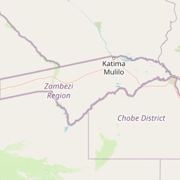
Map view of Sioma Ngwezi National Park

Use this park location map to pinpoint Sioma Ngwezi National Park in Zambia, understand its exact geographic position, and read its mapped placement within the surrounding landscape more clearly.

Pigeon | © OpenStreetMap contributors
Park atlas

Map the geographic spread of conservation landscapes in Zambia's southwest corridor and adjacent regions.

Explore Nearby National Parks and Protected Areas Adjacent to Sioma Ngwezi National Park
After exploring Sioma Ngwezi National Park, browse additional national parks and protected areas across Zambia's remote southwest, including its critical transboundary conservation landscapes. Map the geographic context, compare ecological corridors, and trace the regional spread of protected zones from the Silowana Plains into adjacent country borders for broader discovery.
National parkCaprivi Region

Mudumu National Park National Park: Discover its Protected Landscape and Geographic Boundaries

Mapping the protected area and regional landscape context in Caprivi Region.

Navigate the protected geography of Mudumu National Park, a designated national park situated within the Caprivi Region. This entry provides a structured atlas view of its mapped boundaries and landscape context. Gain a clear understanding of its protected status and its place within the regional geographic framework, offering essential detail for map-based exploration of natural areas in Namibia.

Area
737 km²
Established
1990
Relief
Lowland
Climate
Tropical
National parkZambezi Region

Bwabwata National Park: National Park in the Zambezi Region, Namibia

Explore savanna ecosystem and riverine landscapes.

Bwabwata National Park represents a significant protected landscape in Namibia's Zambezi Region, notable for its integrated community conservation model and its function as a vital wildlife corridor. This national park spans the Caprivi Strip, featuring savanna woodlands and crucial riparian zones along the Okavango and Kwando rivers. As a key component of the Kavango-Zambezi Transfrontier Conservation Area, it facilitates significant elephant migrations, providing rich opportunities for atlas-based exploration of mapped protected areas and regional geography.

Area
6,274 km²
Established
2007
IUCN
II
Relief
Lowland
National parkNamibia

Nkasa Rupara National Park: A Protected Landscape within Namibia's Geography

Explore the mapped protected area and its regional landscape context.

Nkasa Rupara National Park represents a distinct protected landscape within Namibia. This entry provides detailed geographic context, focusing on the park's mapped boundaries and its role as a national park. Understand how this protected area contributes to the broader regional geography, offering a focal point for atlas-based exploration of Namibia's natural lands.

Area
320 km²
Established
1990
IUCN
II
Relief
Lowland
National parkAngola

Luengue-Luiana National Park: Angola's Premier Protected Woodland and Floodplain Ecosystem

Mapping crucial habitats for large mammals and avian wildlife.

Luengue-Luiana National Park is a vital protected landscape in southeastern Angola, covering an immense area that transitions from open woodland ecosystems to vast, seasonal floodplain grasslands. As a cornerstone of the Kavango-Zambezi Transfrontier Conservation Area, it facilitates critical wildlife movements and supports significant populations of large mammals. Its geography provides essential habitat, particularly within the extensive wetland wilderness and riparian zones along the Cuando River, making it a significant site for regional biodiversity and atlas exploration.

Area
42,000 km²
Established
2011
IUCN
II
Relief
Lowland
National parkBotswana

Chobe National Park: Botswana National Park Atlas and Mapped Landscape Explorer

Discover Botswana's diverse protected areas and unique savanna wetlands.

Chobe National Park represents a cornerstone of protected land discovery in Botswana, offering an unparalleled glimpse into a landscape shaped by dynamic water systems and iconic wildlife. This national park is not merely a destination; it is a vital ecosystem supporting vast elephant populations and showcasing a remarkable variety of terrain from riverine floodplains to savanna marshes. Understanding Chobe National Park through its mapped boundaries and regional geographic context reveals its significance as a protected natural area with diverse habitats supporting critical conservation efforts.

Area
11,700 km²
Established
1967
IUCN
II
Relief
Mixed relief
National parkHwange District

Zambezi National Park: National Park within Hwange District's Geographic Landscape

Explore mapped boundaries and protected area context.

Delve into Zambezi National Park, a designated national park situated in Hwange District. This entry provides foundational geographic and landscape context, highlighting the park's protected status and its position within the regional terrain. Understand the atlas significance and mapped features of this conservation landscape for informed discovery.

Area
560 km²
Established
1979
Relief
Lowland
Climate
Subtropical
National parkZimbabwe

Victoria Falls National Park: A Protected Landscape Within Zimbabwe's Geography

Atlas exploration of park boundaries and natural terrain.

Victoria Falls National Park is a key component of Zimbabwe's protected natural areas. This page provides structured information ideal for atlas-based exploration, detailing the park's geographic position and mapped landscape features. Understand its significance as a national park and its contribution to the region's conservation geography.

Area
23.4 km²
IUCN
II
Relief
Mixed relief
Climate
Tropical
National parkSouthern Province

Mosi-oa-Tunya National Park: National Park Exploration and Geographic Atlas

Mapped boundaries and protected landscape context in Southern Province, Zambia.

Gain a comprehensive understanding of Mosi-oa-Tunya National Park, a designated national park in Zambia's Southern Province. This entry focuses on its protected area identity, mapped geographic scope, and its position within the regional atlas. Discover the essential landscape context and the structured geographic information that defines this important conservation area, providing a factual foundation for atlas-based exploration.

Area
66 km²
IUCN
II
Climate
Subtropical
Access
Easy access

Common questions about visiting, size, designation, and location context for Sioma Ngwezi National Park

Sioma Ngwezi National Park FAQs for park facts, access, geography, and protected area context
Find quick answers about Sioma Ngwezi National Park, including protected-area facts, park geography, trail and visitor context, and how the park fits into its surrounding country and regional landscape.
MoriAtlas Explorer

Continue Your Protected Areas Search Across the Global Atlas

Deepen your exploration by continuing the structured search for national parks and protected areas worldwide. Utilize the comprehensive filtering capabilities to compare different conservation landscapes and refine your understanding of global park geography. Discover more about the distribution and characteristics of protected natural areas.

Global natural geography


