

Mori Atlas logo
National parkZambezi National Park

Trace the mapped boundaries and regional landscape context of this protected area.

Zambezi National Park: A National Park in Hwange District for Geographic Discovery

Zambezi National Park represents a significant protected landscape within Hwange District, Zimbabwe. This page offers a detailed geographic exploration, focusing on the park's mapped boundaries and its place in the surrounding natural terrain. Understand the protected-area identity and landscape context through structured data and visual mapping tools designed for comprehensive atlas exploration.

Riverine ecosystemsBig Five wildlifeBirdwatchingSavanna woodlandsZambezi RiverSafari destinations

Zambezi National Park

National park

Park overview

Structured park overview, official facts, and landscape profile for Zambezi National Park

Zambezi National Park park facts, protected area profile, and essential visitor context

Review the core facts for Zambezi National Park, including designation, size, terrain, visitor scale, habitats, and operating context in one park-focused overview.

About Zambezi National Park

Zambezi National Park occupies a distinctive position in Zimbabwe's protected area network, bridging the gap between the high-profile Victoria Falls tourism corridor and the vast wilderness areas of Hwange National Park to the south. The park's 56,000 hectares encompass a remarkable diversity of habitats, from the verdant riverbanks and islands of the Zambezi to the more open savanna landscapes of the Chamabonda Vlei. This habitat variation supports a corresponding richness of wildlife, with the park hosting all four members of Africa's storied big five: African elephant, lion, Cape buffalo, and leopard. The Zambezi River itself is a major ecological artery, providing water and sustenance to the park's interior and creating a migration corridor for countless species. Visitors can explore the park via an extensive game drive network that follows the riverbanks, with several lodges and camps offering overnight stays within the park boundaries. The combination of accessible wildlife viewing, scenic river landscapes, and proximity to Victoria Falls makes Zambezi National Park a cornerstone of Zimbabwe's safari tourism offering.

Quick facts and research context for Zambezi National Park

Zambezi National Park lies in Hwange District, Zimbabwe, along the Zambezi River upstream from Victoria Falls. The park spans 560 square kilometers and was established in 1979 after separating from Victoria Falls National Park. A road to Kazungula bisects the park, creating distinct riverine and Chamabonda Vlei zones. The ecosystem is predominantly Zambezian and Mopane woodlands, with a southern portion classified as Zambezian Baikiaea woodlands. The park supports over 400 bird species and 75 fish species, including the iconic tiger fish.

Protection and recognition

Tracking the official conservation status and terrestrial boundary history established in 1979

Zambezi National Park Protection Status and Designated Terrestrial Boundaries

Researchers and conservation explorers can verify the official terrestrial protection status of Zambezi National Park through documented global database records. Verifying the 1979 designation year and the World Database on Protected Areas registry helps clarify the regional conservation framework of the Zambezi basin.

Protection details

Protection scope
Terrestrial
Designated year
1979
WDPA ID
45513613
Park context

Deeper park guide and search-rich context for Zambezi National Park

Zambezi National Park history, landscape, wildlife, and travel context

Explore Zambezi National Park through its history, landscape character, ecosystems, wildlife, conservation priorities, cultural context, and seasonal travel timing in a structured park guide built for atlas discovery and search intent.

Why Zambezi National Park stands out

Zambezi National Park is best known for its exceptional wildlife viewing along the Zambezi River, where elephants, buffalo, and hippos congregate at waterholes and riverbanks. The park offers some of the best birdwatching in Zimbabwe, with species such as Pel's fishing owl, African skimmer, goliath heron, and the distinctive African finfoot inhabiting the riverine corridors. The tiger fish, one of Africa's most prized sporting fish, draws anglers to the Zambezi's waters. The park's proximity to Victoria Falls makes it a natural complement to the falls visit, yet it retains a quiet, uncrowded atmosphere even during peak tourist seasons.

Zambezi National Park history and protected-area timeline

Zambezi National Park was established in 1979 when the Zimbabwean government carved it out of the larger Victoria Falls National Park, creating a dedicated protected area that could be managed specifically for wildlife conservation and sustainable tourism. This separation reflected a growing recognition that the unique riverine ecosystems of the Zambezi required focused management attention separate from the more arid woodland landscapes that characterized the former combined park. The park's creation came during a period when Zimbabwe was developing its modern conservation framework, building on earlier colonial-era protected area traditions while expanding access and management capacity. The decision to maintain a separate park entity allowed for more targeted conservation efforts focused on the riverine and woodland habitats that define the Zambezi corridor.

Zambezi National Park landscape and geographic character

The landscape of Zambezi National Park is defined by the interaction between the perennial Zambezi River and the surrounding woodland and savanna ecosystems. Along the riverbank, narrow strips of riparian forest create a lush green corridor against the generally drier terrain, with riverine trees such as ebony and various acacia species providing shade and habitat for many bird and mammal species. The park is bisected by the road to Kazungula, which conveniently divides the park into two distinct character areas. The western portion along the river features more dense vegetation and better wildlife concentrations near the water, while the eastern Chamabonda Vlei side offers more open savanna with seasonal pans and clearer views of wildlife at a distance. The southern reaches of the park transition into the Zambezian Baikiaea woodlands, a distinct ecological community characterized by the iconic Baikiaea plurijuga tree, also known as the Zambezi redwood. The overall terrain is relatively flat with gentle undulations, punctuated by the occasional rocky outcrop and the seasonal watercourses that fill during the rainy season.

Zambezi National Park ecosystems, habitats, and plant life

The ecological character of Zambezi National Park reflects its position within the Zambezian biogeographic region, a vast sweep of southern African savanna that extends across multiple countries. The park's dominant vegetation type is the Zambezian and Mopane woodlands, characterized by the extensive presence of Colophospermum mopane, a tree species that dominates much of the landscape and gives the park its distinctive appearance during the dry season when the leaves turn a muted yellow-green. The riverine areas support a different suite of plant species adapted to the higher water table and periodic flooding, including various figs, sycamores, and water-resistant shrubs. The southern portion of the park falls within the Zambezian Baikiaea woodlands, where the Baikiaea tree forms a distinct canopy layer over a grassy understory. These woodland systems support a complex web of ecological interactions, from pollination and seed dispersal to predator-prey relationships that sustain the park's wildlife populations.

Zambezi National Park wildlife and species highlights

Zambezi National Park supports an impressive roster of mammalian species, headlined by the African elephant, which is regularly encountered along the river and at waterholes throughout the park. Herds of Cape buffalo are a common sight, often numbering in the hundreds during the dry season when they congregate around the limited water sources. Lion and leopard maintain viable populations in the park, though they are more elusive than the herbivores and require patience and luck to observe. The antelope community is particularly diverse, with sable antelope, common eland, greater kudu, waterbuck, impala, common zebra, and Southern giraffe all present in significant numbers. The birdlife is exceptional, with over 400 species recorded, including the highly sought Pel's fishing owl, which hunts fish along the river, the distinctive African skimmer that skims the water's surface, the goliath heron standing sentinel at water's edge, and the African finfoot, a secretive riverine specialist. The Zambezi River itself supports approximately 75 fish species, with the tiger fish being the most famous, prized by anglers for its fighting ability and sharp teeth.

Zambezi National Park conservation status and protection priorities

Zambezi National Park plays an important role in Zimbabwe's conservation estate by protecting a representative sample of the Zambezian woodland and riverine ecosystems. The park's position along a major river system means it serves as a corridor for wildlife migration and provides critical water access for species ranging from elephants to birds. The protected status ensures that the woodland habitats remain intact despite surrounding agricultural and settlement pressures. The park's management balances conservation objectives with tourism access, with the fee revenue from visitors helping to fund ongoing protection and infrastructure maintenance. The proximity to Victoria Falls also creates an economic incentive for conservation, as the park's wildlife populations are a key attraction that supports local employment and community benefits.

Zambezi National Park cultural meaning and human context

Zambezi National Park lies within the traditional territory of the Batonga and other indigenous groups who have lived along the Zambezi River for generations. The river has long been a source of fish, water, and transportation for local communities, and the landscape holds cultural significance beyond its modern conservation designation. The park's establishment created new frameworks for land use and wildlife management that affected local communities, with subsequent initiatives working to ensure that conservation benefits flow to surrounding villages. The area also has historical connections to the broader regional trade routes and movement patterns that shaped the development of the Zambezi valley over centuries.

Top sights and standout views in Zambezi National Park

The Zambezi River Game Drive offers visitors the opportunity to explore the park along the riverbanks, where elephants, buffalo, and hippos are regularly spotted. The Chamabondo Game Drive penetrates the wilder southern reaches of the park, offering more remote wildlife encounters in a less-visited landscape. The birdwatching along the river is exceptional, with chances to see Pel's fishing owl, African finfoot, and the acrobatic African skimmer. Fishing for tiger fish in the Zambezi draws anglers from around the world, with several operators offering catch-and-release excursions. The park's lodges and camps provide comfortable accommodation options that allow guests to experience the sounds and rhythms of the African bush.

Best time to visit Zambezi National Park

The optimal time to visit Zambezi National Park is during the dry season from April to October, when wildlife concentrates around water sources and vegetation is less dense, making animal spotting easier. The cooler months of May to August offer comfortable temperatures for game drives, though mornings can be chilly. The hot season from September to November brings intense heat but excellent wildlife viewing as animals seek relief at the river. The rainy season from November to March transforms the landscape with fresh green growth and migratory bird arrivals, though some roads may become difficult to navigate and wildlife becomes more dispersed.

Monthly climate preview

Long-term temperature and precipitation normals for the Hwange District landscape

Zambezi National Park Climate Profile and Historical Weather by Month

Long-term climatology at the representative high-elevation baseline indicates distinct seasonal temperature shifts alongside highly variable monthly rainfall patterns. Accessing the complete twelve-month profile reveals deep patterns in average minimums, maximum peaks, and daily precipitation averages for Zambezi National Park.
Annual mean23 °C
17 °C28 °C
Jan25°
Feb24°
Mar24°
Apr23°
May20°
Jun18°
Jul17°
Aug20°
Sep25°
Oct28°
Nov27°
Dec26°
Warmest month
October

27.8 °C

Coolest month
July

16.9 °C

Wettest month
January

4.7 mm/day

Driest month
August

0 mm/day

Park location guide

Geography guide, regional context, and park location map for Zambezi National Park

Zambezi National Park park geography, regions, and map view in Zimbabwe

Understand where Zambezi National Park sits in Zimbabwe through a broader geographic reading of the surrounding landscape, nearby location context, and its mapped position within the national park landscape.

How Zambezi National Park fits into Zimbabwe

Zimbabwe is a landlocked nation in Southeast Africa located between the Zambezi and Limpopo rivers. The country has a population of roughly 17 million people and uses English, Shona, and Ndebele as its primary languages. Once the site of the ancient Kingdom of Zimbabwe and the city of Great Zimbabwe, it gained independence from the United Kingdom in 1980.

Wider geography shaping Zambezi National Park in Zimbabwe

Zimbabwe is located in Southeast Africa between the Zambezi River to the north and the Limpopo River to the south. It is landlocked, bordered by South Africa, Botswana, Zambia, and Mozambique. The terrain includes highlands, savanna, and the Zambezi valley.

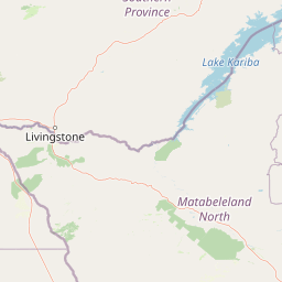
Map view of Zambezi National Park

Use this park location map to pinpoint Zambezi National Park in Zimbabwe, understand its exact geographic position, and read its mapped placement within the surrounding landscape more clearly.

Pigeon | © OpenStreetMap contributors

Location context for Zambezi National Park

Hwange District
Park atlas

Trace the regional spread of protected areas, comparing riverine, savanna, and woodland ecosystems connected to Zambezi National Park's geography.

Explore Other National Parks and Protected Areas Near Zambezi National Park

Continue your park discovery beyond Zambezi National Park by exploring other national parks and protected areas in the surrounding Zimbabwean and regional landscapes. Map their geographic context, compare diverse riverine and savanna ecosystems, and trace interconnected conservation efforts across a broader protected-area spread.
National parkZimbabwe
About 20 km away#1 closest

East

Victoria Falls National Park: A Protected Landscape Within Zimbabwe's Geography

Atlas exploration of park boundaries and natural terrain.

Victoria Falls National Park is a key component of Zimbabwe's protected natural areas. This page provides structured information ideal for atlas-based exploration, detailing the park's geographic position and mapped landscape features. Understand its significance as a national park and its contribution to the region's conservation geography.

Area
23.4 km²
IUCN
II
Relief
Mixed relief
Climate
Tropical
National parkSouthern Province
About 22 km away#2 closest

East

Mosi-oa-Tunya National Park: National Park Exploration and Geographic Atlas

Mapped boundaries and protected landscape context in Southern Province, Zambia.

Gain a comprehensive understanding of Mosi-oa-Tunya National Park, a designated national park in Zambia's Southern Province. This entry focuses on its protected area identity, mapped geographic scope, and its position within the regional atlas. Discover the essential landscape context and the structured geographic information that defines this important conservation area, providing a factual foundation for atlas-based exploration.

Area
66 km²
IUCN
II
Climate
Subtropical
Access
Easy access
National parkZimbabwe
About 49 km away#3 closest

South

Kazuma Pan National Park: Zimbabwe National Park Atlas and Protected Landscape Exploration

Unique plains landscape with reliable dry-season wildlife viewing.

Kazuma Pan National Park offers a rare glimpse into Zimbabwe's expansive grassy plains and vital pans, creating a unique protected landscape. This national park is critical for understanding regional wildlife migrations and the geographic context of conservation areas in northwestern Zimbabwe, providing an essential entry point for atlas-based exploration of its terrain and ecological significance.

Area
313 km²
Established
1975
IUCN
II
Relief
Lowland
National parkBotswana
About 50 km away#4 closest

Southwest

Chobe National Park: Botswana National Park Atlas and Mapped Landscape Explorer

Discover Botswana's diverse protected areas and unique savanna wetlands.

Chobe National Park represents a cornerstone of protected land discovery in Botswana, offering an unparalleled glimpse into a landscape shaped by dynamic water systems and iconic wildlife. This national park is not merely a destination; it is a vital ecosystem supporting vast elephant populations and showcasing a remarkable variety of terrain from riverine floodplains to savanna marshes. Understanding Chobe National Park through its mapped boundaries and regional geographic context reveals its significance as a protected natural area with diverse habitats supporting critical conservation efforts.

Area
11,700 km²
Established
1967
IUCN
II
Relief
Mixed relief
National parkMatabeleland North
About 78 km away#5 closest

Southeast

Hwange National Park: Explore its Mapped Boundaries and Protected Landscape in Matabeleland North

National Park with distinct geographic and landscape context.

Gain a structured understanding of Hwange National Park, a designated national park within the Matabeleland North region of Zimbabwe. This detailed entry focuses on its precise mapped boundaries and its contribution to the regional geography. Ideal for atlas-based discovery, it highlights Hwange National Park as a key protected landscape for understanding conservation and natural terrain distribution.

Area
14,651 km²
Established
1961
IUCN
II
Relief
Lowland
National parkZambia
About 143 km away#6 closest

North

Kafue National Park: Zambia's Key National Park for Geographic and Protected Area Exploration

Mapped boundaries and landscape context in southern Africa.

Kafue National Park represents a vital component of Zambia's protected lands, offering a distinct perspective for atlas-driven geographic exploration. This national park's identity is tied to its extensive mapped boundaries and its contribution to the regional landscape of southern Africa. Users engaging with this entry can uncover the protected area's specific geographic context and map-based details, enhancing their understanding of conservation landscapes.

Area
22,400 km²
IUCN
II
Relief
Lowland
Climate
Tropical
National parkBotswana
About 190 km away#7 closest

South

Nxai Pan National Park: Botswana's Iconic Baobab Forests and Salt Pan Landscape

Explore mapped boundaries and unique regional geography.

Nxai Pan National Park offers a compelling glimpse into Botswana's unique semi-arid ecosystems, characterized by the expansive, salt-crusted Nxai Pan itself and the iconic Baines Baobabs dotting its edges. As a protected national park, it represents a significant conservation landscape within the Kalahari Desert region. Understanding its geography involves appreciating the stark visual contrasts, seasonal wetland transformations, and the vast openness of the salt pan environment.

Area
2,578 km²
Established
1992
IUCN
Ib
Relief
Lowland
National parkZambia
About 207 km away#8 closest

West

Sioma Ngwezi National Park: Zambia's National Park, Mapped Protected Landscape Explorer

Discover the geographic context and protected area boundaries of Sioma Ngwezi National Park.

Sioma Ngwezi National Park is a key protected area within Zambia, offering significant opportunities for geographic discovery. This national park's mapped boundaries define a significant natural landscape, providing crucial context for regional atlas exploration. Users can explore the park's specific identity as a conservation territory and understand its placement within Zambia's diverse terrain. The focus here is on the park's structured geographic data and its role in mapping protected lands across Southern Africa.

Area
5,000 km²
Relief
Lowland
Climate
Subtropical
Access
Remote access

Common questions about visiting, size, designation, and location context for Zambezi National Park

Zambezi National Park FAQs for park facts, access, geography, and protected area context

Find quick answers about Zambezi National Park, including protected-area facts, park geography, trail and visitor context, and how the park fits into its surrounding country and regional landscape.
MoriAtlas Explorer

Continue Your Protected Areas Search Across the Global Atlas

Deepen your exploration by continuing the structured search for national parks and protected areas worldwide. Utilize the comprehensive filtering capabilities to compare different conservation landscapes and refine your understanding of global park geography. Discover more about the distribution and characteristics of protected natural areas.

Global natural geography
