

Mori Atlas logo
National parkMudumu National Park

Explore the mapped boundaries and natural landscape context of this protected area in the Caprivi Region.

Mudumu National Park National Park: Protected Area Mapping and Regional Geography

Mudumu National Park represents a significant protected landscape within the Caprivi Region of Namibia. This page offers a detailed atlas-style exploration of its geographic extent, mapped park boundaries, and the surrounding natural terrain. Understand how Mudumu National Park fits into the regional geography and its importance as a protected area, providing essential context for any map-based discovery of Namibia's natural landscapes.

Trans-frontier conservationKavango-ZambeziMopane woodlandElephant migration corridorRiparian forestFloodplain ecosystem

Mudumu National Park

National park

Park overview

Structured park overview, official facts, and landscape profile for Mudumu National Park

Mudumu National Park park facts, protected area profile, and essential visitor context
Review the core facts for Mudumu National Park, including designation, size, terrain, visitor scale, habitats, and operating context in one park-focused overview.

About Mudumu National Park

Mudumu National Park represents a vital protected area in Namibia's north-eastern corner, where the flat Kalahari landscape meets the lush riparian environments created by the Kwando River. Established in 1990, the park covers 737 square kilometres and forms an unbroken connection with neighbouring protected areas and communal conservancies across international boundaries. The park sits at the heart of the Kavango-Zambezi Trans-Frontier Conservation Area, a massive trans-frontier initiative that links protected areas across five southern African nations and aims to restore historic wildlife migration routes while providing economic benefits to local communities. Unlike many fenced game reserves, Mudumu remains completely open, allowing wildlife to move freely between Namibia, Botswana, Angola and Zambia in search of water and grazing. The park is managed as part of the Mudumu North and Mudumu South complexes, which group formally protected areas with surrounding conservancies and forestry management areas into integrated management units. This collaborative approach involves stakeholders from government agencies, local communities, and private lodge operators in law enforcement, anti-poaching efforts, fire management and wildlife monitoring.

Quick facts and research context for Mudumu National Park

Mudumu National Park occupies 737 square kilometres in north-eastern Namibia's Caprivi Region, situated approximately 35 kilometres south of Kongola. The park was established in 1990, shortly before Namibia's independence, and forms part of the Kavango-Zambezi Trans-Frontier Conservation Area. The flat terrain features a fossilized river course called the Mudumu Mulapo at its centre, which drains seasonal water from the surrounding mopane woodlands. Average annual rainfall ranges between 550 and 700 millimetres, with the peak rainy season occurring in January and February. The park is unfenced with no formal entrance gate, and the C49 road provides vehicle access linking Kongola and Sangwali villages. A total of 430 bird species have been recorded within the park boundaries.

Park context

Deeper park guide and search-rich context for Mudumu National Park

Mudumu National Park history, landscape, wildlife, and travel context
Explore Mudumu National Park through its history, landscape character, ecosystems, wildlife, conservation priorities, cultural context, and seasonal travel timing in a structured park guide built for atlas discovery and search intent.

Why Mudumu National Park stands out

Mudumu National Park is best known as a critical trans-boundary wildlife corridor within the Kavango-Zambezi Trans-Frontier Conservation Area. The park's unfenced landscape provides a crucial migration route for African elephant and other large game species moving between Botswana and Angola. It supports one of the region's significant elephant populations alongside substantial herds of buffalo, lion, leopard, and African wild dog. The combination of mopane woodlands, riverine forests, and floodplain ecosystems creates a diverse habitat that supports both large mammals and more than 400 bird species, including the African fish eagle, African skimmer, and western banded snake eagle.

Mudumu National Park history and protected-area timeline

Mudumu National Park was created in 1990, just before Namibia achieved independence from South African rule. Although the originally approved size for the park was 1,010 square kilometres, the actual protected area covers 737 square kilometres due to various implementation challenges. The park's establishment reflected Namibia's commitment to conservation following independence, and it was integrated into the country's national park system managed by the Ministry of Environment and Tourism. Since 2006, the NamParks Project, co-funded by the German federal government through KfW development bank, has supported infrastructure development, wildlife translocations, tourism planning, and community partnership building in Mudumu and four other northern Namibian parks. The park is managed as part of a unified system that includes Bwabwata, Khaudom, Mangetti and Nkasa Lupala National Parks.

Mudumu National Park landscape and geographic character

The terrain of Mudumu National Park is entirely flat, lacking hills or significant elevation changes. A prominent geological feature is the Mudumu Mulapo, a fossilized river course that runs through the centre of the park as a seasonally dry, open channel. This ancient watercourse drains the mopane woodlands of the hinterland to the east, carrying seasonal floodwaters during periods of heavy rainfall. The park's western boundary follows the course of the Kwando River, which creates a green corridor of riparian vegetation against the surrounding Kalahari savanna. The landscape encompasses several distinct vegetation types: north-eastern Kalahari woodlands on the sandy uplands, dense riverine woodlands along the Kwando floodplain, Caprivi mopane woodland in the interior areas, and seasonal floodplains that transform into grasslands during the wet season. The entire park is unfenced, with a graded track called a cutline separating the protected area from neighbouring communal farmland.

Mudumu National Park ecosystems, habitats, and plant life

Mudumu sits within the tree and shrub savanna biome of southern Africa, where the characteristic vegetation reflects the region's climate and soil conditions. The dominant tree species is mopane, which forms extensive woodlands across the park's interior and provides important dry-season browse for elephants and other herbivores. Wild syringa, leadwood and mangosteen are also common throughout the woodland areas, while the riverbanks and floodplains support denser riparian forests with different species adapted to the more humid conditions. The Kwando River floodplain creates seasonal wetlands that attract numerous waterfowl and provide critical grazing for red lechwe and other floodplain-dependent species. The combination of woodland, forest and floodplain habitats within a single unfenced protected area supports remarkable ecological diversity and allows wildlife to follow seasonal resources across different habitat types.

Mudumu National Park wildlife and species highlights

Mudumu supports substantial populations of large African mammals, with African elephant being particularly prominent. The park contains significant herds of African buffalo, and the predator community includes lion, leopard, spotted hyena, cheetah and African wild dog. Hippopotamus and Nile crocodile inhabit the Kwando River and its oxbow lagoons, while the floodplain areas support sitatunga, red lechwe and other wetland-adapted antelope. Sable antelope, giraffe and common eland have been reintroduced to the park, supplementing populations of impala, plains zebra, blue wildebeest and other common savanna species. The bird fauna is exceptionally diverse with 430 species recorded, including the African fish eagle, African skimmer, and western banded snake eagle. The park notably lacks both black and white rhinoceros, and tiger fish and tilapia are common in the river systems.

Mudumu National Park conservation status and protection priorities

Mudumu National Park plays a central role in regional conservation as part of the Kavango-Zambezi Trans-Frontier Conservation Area, which aims to create Africa's largest trans-boundary conservation landscape. The park's unfenced design is intentional, allowing historic wildlife migration routes to function once again and enabling elephant, buffalo, roan and sable antelope to move freely between Botswana, Angola, Namibia and Zambia. This trans-frontier approach addresses one of the greatest challenges in modern African conservation: creating wildlife corridors that span international boundaries while providing economic benefits to local communities who share the landscape with large animals. The integrated park management model used at Mudumu brings together government authorities, neighbouring conservancies and community forest managers to coordinate anti-poaching efforts, fire management, wildlife monitoring and sustainable tourism development across jurisdictional boundaries.

Top sights and standout views in Mudumu National Park

The park's strategic position at the heart of the Kavango-Zambezi Trans-Frontier Conservation Area makes it a vital corridor for elephant migration across southern Africa. The unfenced landscape allows wildlife to move freely between countries, recreating natural movement patterns that existed before fences and borders fragmented wildlife populations. The Kwando River floodplain provides a spectacular setting for game viewing, with hippos, crocodiles and abundant waterfowl in the wet season. Walking safaris, bird watching and game drives are the primary tourism activities, with two privately managed lodges offering accommodation within the park. The lack of formal gates and the remote location create a wilderness experience quite different from more developed southern African parks.

Best time to visit Mudumu National Park

The optimal time to visit Mudumu National Park is during the dry season from May to October, when vegetation thins and wildlife concentrates around remaining water sources, making game viewing more productive. The hot dry season from September to November offers excellent viewing conditions, though temperatures can be high. The rainy season from November to April brings lush green scenery and excellent birdwatching as migratory species arrive, but some roads become difficult to traverse and the park recommends traveling in convoys of at least two vehicles during this period. The peak rainfall occurs in January and February, when flooding can be extensive in low-lying areas. Visitors should be aware that Mudumu lies within a high-risk malaria zone and should take appropriate preventive measures.

Park location guide

Geography guide, regional context, and park location map for Mudumu National Park

Mudumu National Park park geography, regions, and map view in Namibia
Understand where Mudumu National Park sits in Namibia through a broader geographic reading of the surrounding landscape, nearby location context, and its mapped position within the national park landscape.

How Mudumu National Park fits into Namibia

Namibia is a sovereign country in Southern Africa that gained independence from South Africa in 1990. It is the driest country in sub-Saharan Africa, characterized by the Namib Desert along its coast. The population is approximately 3 million, with Windhoek as the capital and largest city. Namibia operates as a unitary semi-presidential republic with a multi-party system.

Wider geography shaping Mudumu National Park in Namibia

Namibia occupies 825,615 km2 in Southern Africa, making it the 34th largest country in the world. It is bordered by the Atlantic Ocean to the west, Angola and Zambia to the north, Botswana to the east, and South Africa to the south. The country features the Namib Desert along its coastal region, with varied terrain including savannas, mountains, and plateaus inland. A notable geographic feature is that Zimbabwe lies less than 200 metres away along the Zambezi river near Kazungula in the northeast.

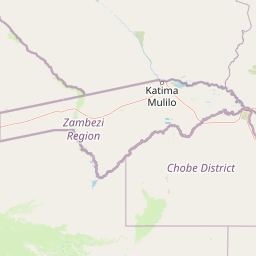
Map view of Mudumu National Park

Use this park location map to pinpoint Mudumu National Park in Namibia, understand its exact geographic position, and read its mapped placement within the surrounding landscape more clearly.

Pigeon | © OpenStreetMap contributors

Location context for Mudumu National Park

Caprivi Region
Park atlas

Discover nearby national parks and protected areas, tracing the regional geography around Mudumu National Park and the Kavango-Zambezi ecosystem.

Continue Your Discovery: National Parks and Protected Areas Near Mudumu National Park
Users can browse additional national parks and protected areas geographically adjacent to Mudumu National Park, covering key landscapes within the Caprivi Region and the expansive Kavango-Zambezi Trans-Frontier Conservation Area. This expanded atlas view allows for direct comparison of park ecosystems, conservation strategies, and regional connectivity across southern Africa's crucial wildlife corridors.
National parkNamibia

Nkasa Rupara National Park: A Protected Landscape within Namibia's Geography

Explore the mapped protected area and its regional landscape context.

Nkasa Rupara National Park represents a distinct protected landscape within Namibia. This entry provides detailed geographic context, focusing on the park's mapped boundaries and its role as a national park. Understand how this protected area contributes to the broader regional geography, offering a focal point for atlas-based exploration of Namibia's natural lands.

Area
320 km²
Established
1990
IUCN
II
Relief
Lowland
National parkZambia

Sioma Ngwezi National Park: Zambia's National Park, Mapped Protected Landscape Explorer

Discover the geographic context and protected area boundaries of Sioma Ngwezi National Park.

Sioma Ngwezi National Park is a key protected area within Zambia, offering significant opportunities for geographic discovery. This national park's mapped boundaries define a significant natural landscape, providing crucial context for regional atlas exploration. Users can explore the park's specific identity as a conservation territory and understand its placement within Zambia's diverse terrain. The focus here is on the park's structured geographic data and its role in mapping protected lands across Southern Africa.

Area
5,000 km²
Relief
Lowland
Climate
Subtropical
Access
Remote access
National parkBotswana

Chobe National Park: Botswana National Park Atlas and Mapped Landscape Explorer

Discover Botswana's diverse protected areas and unique savanna wetlands.

Chobe National Park represents a cornerstone of protected land discovery in Botswana, offering an unparalleled glimpse into a landscape shaped by dynamic water systems and iconic wildlife. This national park is not merely a destination; it is a vital ecosystem supporting vast elephant populations and showcasing a remarkable variety of terrain from riverine floodplains to savanna marshes. Understanding Chobe National Park through its mapped boundaries and regional geographic context reveals its significance as a protected natural area with diverse habitats supporting critical conservation efforts.

Area
11,700 km²
Established
1967
IUCN
II
Relief
Mixed relief
National parkZambezi Region

Bwabwata National Park: National Park in the Zambezi Region, Namibia

Explore savanna ecosystem and riverine landscapes.

Bwabwata National Park represents a significant protected landscape in Namibia's Zambezi Region, notable for its integrated community conservation model and its function as a vital wildlife corridor. This national park spans the Caprivi Strip, featuring savanna woodlands and crucial riparian zones along the Okavango and Kwando rivers. As a key component of the Kavango-Zambezi Transfrontier Conservation Area, it facilitates significant elephant migrations, providing rich opportunities for atlas-based exploration of mapped protected areas and regional geography.

Area
6,274 km²
Established
2007
IUCN
II
Relief
Lowland
National parkHwange District

Zambezi National Park: National Park within Hwange District's Geographic Landscape

Explore mapped boundaries and protected area context.

Delve into Zambezi National Park, a designated national park situated in Hwange District. This entry provides foundational geographic and landscape context, highlighting the park's protected status and its position within the regional terrain. Understand the atlas significance and mapped features of this conservation landscape for informed discovery.

Area
560 km²
Established
1979
Relief
Lowland
Climate
Subtropical
National parkZimbabwe

Victoria Falls National Park: A Protected Landscape Within Zimbabwe's Geography

Atlas exploration of park boundaries and natural terrain.

Victoria Falls National Park is a key component of Zimbabwe's protected natural areas. This page provides structured information ideal for atlas-based exploration, detailing the park's geographic position and mapped landscape features. Understand its significance as a national park and its contribution to the region's conservation geography.

Area
23.4 km²
IUCN
II
Relief
Mixed relief
Climate
Tropical
National parkZimbabwe

Kazuma Pan National Park: Zimbabwe National Park Atlas and Protected Landscape Exploration

Unique plains landscape with reliable dry-season wildlife viewing.

Kazuma Pan National Park offers a rare glimpse into Zimbabwe's expansive grassy plains and vital pans, creating a unique protected landscape. This national park is critical for understanding regional wildlife migrations and the geographic context of conservation areas in northwestern Zimbabwe, providing an essential entry point for atlas-based exploration of its terrain and ecological significance.

Area
313 km²
Established
1975
IUCN
II
Relief
Lowland
National parkSouthern Province

Mosi-oa-Tunya National Park: National Park Exploration and Geographic Atlas

Mapped boundaries and protected landscape context in Southern Province, Zambia.

Gain a comprehensive understanding of Mosi-oa-Tunya National Park, a designated national park in Zambia's Southern Province. This entry focuses on its protected area identity, mapped geographic scope, and its position within the regional atlas. Discover the essential landscape context and the structured geographic information that defines this important conservation area, providing a factual foundation for atlas-based exploration.

Area
66 km²
IUCN
II
Climate
Subtropical
Access
Easy access

Common questions about visiting, size, designation, and location context for Mudumu National Park

Mudumu National Park FAQs for park facts, access, geography, and protected area context
Find quick answers about Mudumu National Park, including protected-area facts, park geography, trail and visitor context, and how the park fits into its surrounding country and regional landscape.
MoriAtlas Explorer

Continue Your Protected Areas Search Across the Global Atlas

Deepen your exploration by continuing the structured search for national parks and protected areas worldwide. Utilize the comprehensive filtering capabilities to compare different conservation landscapes and refine your understanding of global park geography. Discover more about the distribution and characteristics of protected natural areas.

Global natural geography


