Mori Atlas logo
National parkLiwonde National Park

Discover the geographic boundaries and atlas context of this national park.

Liwonde National Park: A Protected Landscape within Malawi's Southern Region

Liwonde National Park stands as a significant protected area, offering a unique lens into Malawi's natural geography. Situated within the Southern Region, this national park provides vital context for understanding the distribution and mapped boundaries of conservation lands. Users can explore its geographic identity and how it contributes to the regional atlas of protected landscapes.

African ParksPredator ReintroductionShire RiverBlack RhinocerosSavannah EcosystemBirdwatching

Liwonde National Park

National park

Park overview

Structured park overview, official facts, and landscape profile for Liwonde National Park

Liwonde National Park park facts, protected area profile, and essential visitor context
Review the core facts for Liwonde National Park, including designation, size, terrain, visitor scale, habitats, and operating context in one park-focused overview.

About Liwonde National Park

Liwonde National Park represents one of Malawi's most significant protected areas and serves as a flagship for conservation success in southern Africa. The park sits in the Southern Region of Malawi, occupying a strategic position near the Mozambique border and just south of Lake Malawi, with the Shire River providing a vital water source that sustains the entire ecosystem. The landscape consists predominantly of dry savannah and woodlands dominated by mopane trees, interspersed with riverine forests along the Shire and its tributaries, wetlands around Lake Malombe, and open grassland areas that support diverse wildlife populations. The park's location within the Machinga District, with portions extending into Mangochi and Balaka districts, places it at a ecological crossroads between the miombo woodlands of central Africa and the more arid savannah systems of the south. Prior to its establishment in 1973, the land supported subsistence agriculture and fishing communities, and the relocation of residents during gazetting created peripheral villages with relatively high population density that now share boundaries with the park. This human presence has created ongoing challenges for wildlife management, though African Parks' comprehensive fencing initiative completed in 2015 has significantly reduced crop-raiding incidents and human-wildlife conflict. The addition of Mangochi Forest Reserve under management in 2018 expanded the protected landscape considerably and connected Liwonde to a proposed ecoregion called the South East Africa Montane Archipelago, recognizing the broader ecological significance of this mountainous forest ecosystem.

Quick facts and research context for Liwonde National Park

Liwonde National Park is located in the Southern Region of Malawi, primarily within Machinga District while also extending into Mangochi and Balaka districts. The park covers 548 square kilometres and was established in 1973, with African Parks taking over management in 2015. A 129-kilometre electric fence now encircles the park, constructed at a cost of US$1.6 million to reduce human-wildlife conflict and poaching. The park features a 30-kilometre stretch of the Shire River and includes shoreline along Lake Malombe. In 2018, the adjacent Mangochi Forest Reserve was brought under African Parks management, nearly doubling the protected area. The park supports approximately 17,800 large mammals and more than 380 bird species, making it one of Malawi's most biodiverse protected areas.

Park context

Deeper park guide and search-rich context for Liwonde National Park

Liwonde National Park history, landscape, wildlife, and travel context
Explore Liwonde National Park through its history, landscape character, ecosystems, wildlife, conservation priorities, cultural context, and seasonal travel timing in a structured park guide built for atlas discovery and search intent.

Why Liwonde National Park stands out

Liwonde National Park is especially known for its dramatic predator reintroduction programs, having become the first area in Malawi in decades to host wild cheetahs, lions, and African wild dogs. The park's black rhinoceros conservation program, established with a fenced sanctuary in 1993, has expanded significantly with 17 rhinos translocated from South Africa in 2019. The Shire River corridor provides exceptional wildlife viewing opportunities, particularly for hippos, crocodiles, and elephants, while the park's birdlife is remarkable with species such as Lilian's lovebird found nowhere else in Malawi. The mopane woodland and savannah landscape supports healthy populations of sable antelope, waterbuck, buffalo, and the endangered African wild dog, making Liwonde a flagship for conservation in the region.
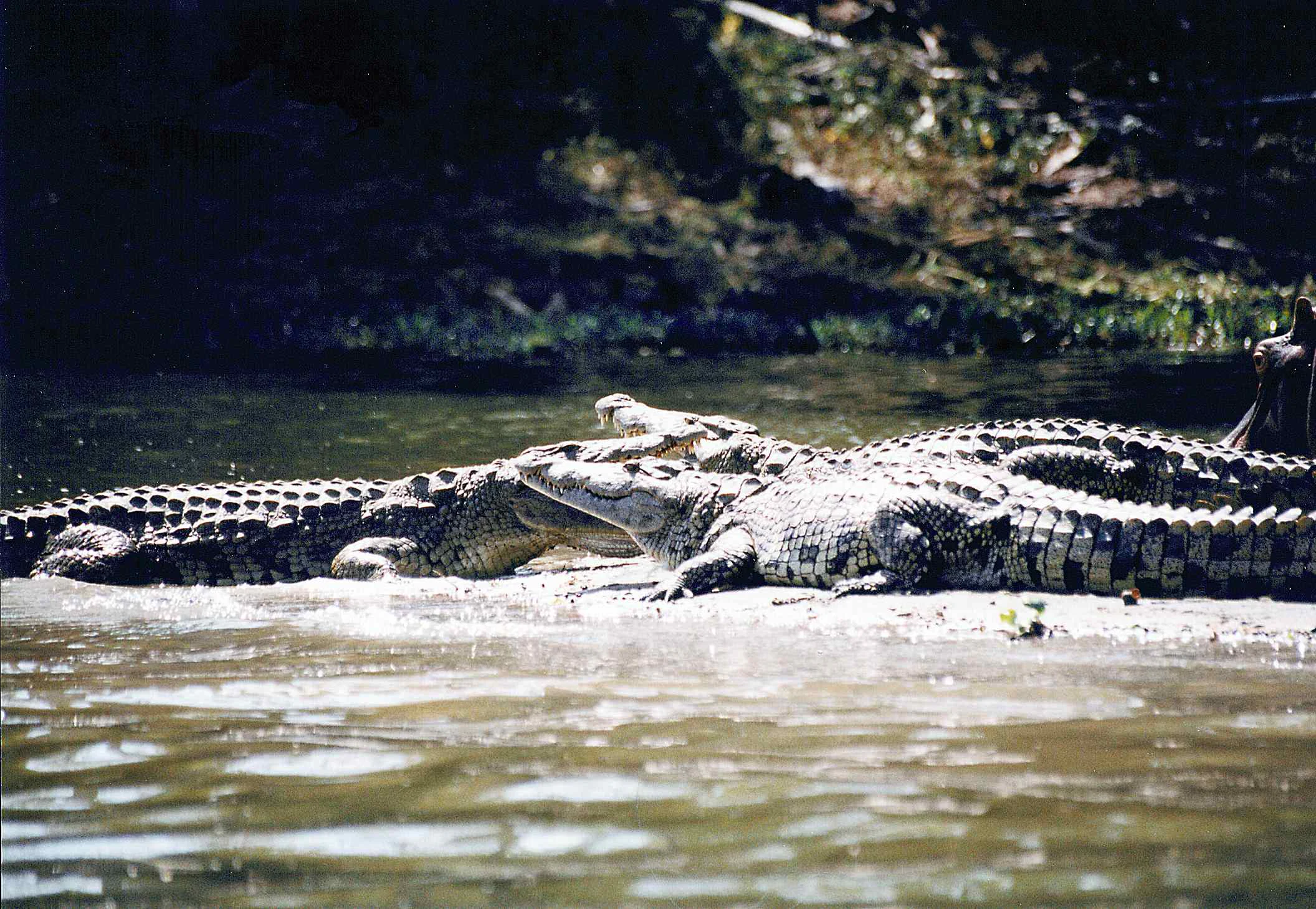
Several crocodiles resting in shallow water near a riverbank.
Crocodiles sunbathing in shallow water at Liwonde National Park.

Liwonde National Park history and protected-area timeline

Liwonde National Park was established in 1973 through the gazetting of land that had previously supported agricultural activities, primarily subsistence farming of cotton, maize, tobacco, and rice, alongside fishing in the Shire River and Lake Malombe. The establishment process required the relocation of numerous residents to communities outside the park boundaries, a process that created peripheral villages with population densities higher than typical for rural Malawi. This historical displacement has contributed to ongoing human-wildlife dynamics around the park's perimeter. Prior to the involvement of African Parks, the park was managed by Malawi's Department of National Parks and Wildlife and faced significant challenges including poaching, human-wildlife conflict, and inadequate infrastructure for effective protection. In August 2015, African Parks was invited by the government to take over management, with the construction of a perimeter fence identified as the immediate priority. The 129-kilometre electric fence was completed at a cost of US$1.6 million and took approximately 18 months to build, with continuous monitoring to prevent both animal escape and poacher intrusion. In 2015, the United Nations Development Programme contributed 8.3 million kwacha through the Upper Shire Association for Conservation of Liwonde National Park to support community involvement in conservation. The addition of Mangochi Forest Reserve to the management portfolio in early 2018 nearly doubled the total protected area and created connectivity to montane forest habitats of regional significance.

Liwonde National Park landscape and geographic character

The physical landscape of Liwonde National Park is defined by the Shire River, which traverses the park for approximately 30 kilometres and forms its western border, creating a vital corridor of water and vegetation that draws wildlife throughout the dry season. The park sits at relatively low elevation, typical of the Shire Valley, with terrain that ranges from flat floodplains along the river to gently rolling hills covered in savannah woodland. The vegetation is dominated by mopane trees, which give the landscape its characteristic appearance and provide important dry-season browse for elephants and other herbivores. Miombo woodland covers portions of the park, while riverine forests fringe the Shire and its tributaries, providing denser cover and habitat for forest-dwelling species. The shoreline of Lake Malombe, located 20 kilometres south of Lake Malawi, adds a significant wetland component to the park's diverse habitats. The landscape also includes open grassland areas, acacia woodlands, and stands of iconic baobab trees scattered across the savannah. Evergreen forests follow smaller tributaries throughout the park, creating microhabitats that support species adapted to more moist conditions within the generally drier surrounding landscape.
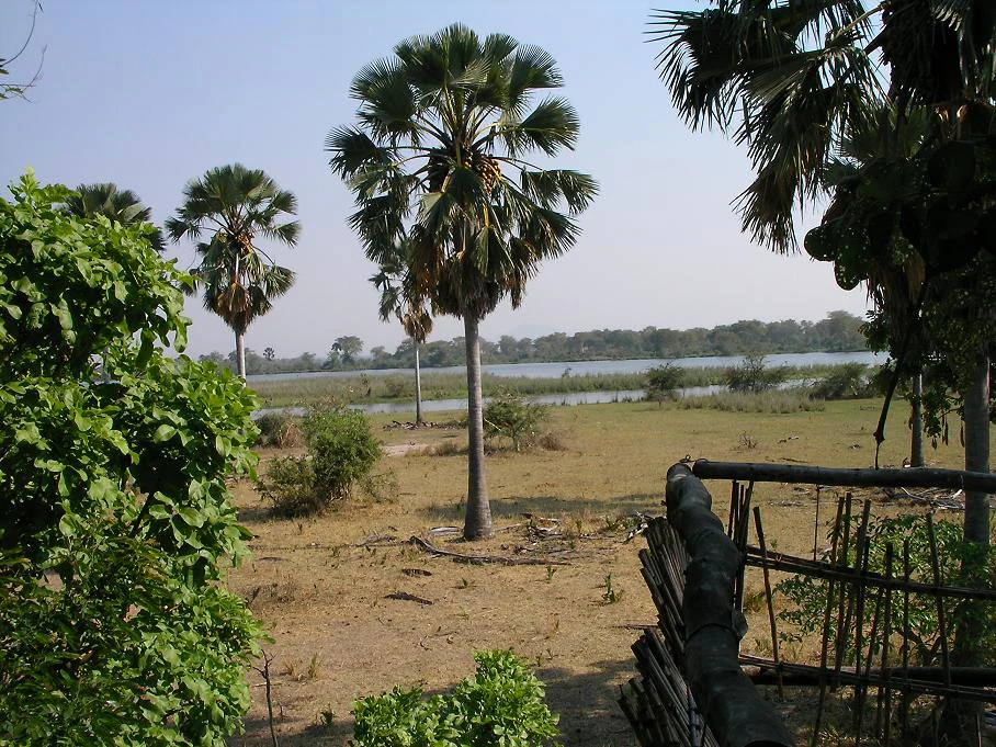
Palm trees and dry grassland landscape with a river visible in the distance under a clear sky
View of the Shire River from Liwonde National Park, Malawi

Liwonde National Park ecosystems, habitats, and plant life

The ecological character of Liwonde National Park reflects its position within the southern African savannah biome, supporting a mixture of woodland and grassland habitats that sustain remarkable biodiversity. The mopane-dominated savannah represents the primary vegetation type, interspersed with miombo woodlands in certain areas and riverine forests along watercourses. The Shire River corridor serves as the ecological backbone of the park, providing permanent water that supports riparian vegetation and creates habitat gradients from riverbank to surrounding woodland. Wetlands around Lake Malombe add ecological diversity, while the various forest types along tributaries provide specialized habitats for species requiring denser cover. The park's position near the Zambia border and south of Lake Malawi places it within a transition zone between different biogeographic regions, contributing to its species diversity. The park's ecological significance led to the inclusion of adjacent Mangochi Forest Reserve within a proposed South East Africa Montane Archipelago ecoregion, recognizing the importance of connected forest habitats in this area.

Liwonde National Park wildlife and species highlights

Liwonde National Park supports an impressive diversity of wildlife, with approximately 17,800 large mammals representing numerous species and more than 380 bird species recorded within its boundaries. The large mammal community includes African elephants, hippos, African buffalo, and a full complement of savannah antelopes including endangered sable antelope, common eland, waterbuck, impala, kudu, and bushbuck. The park was historically home to black rhinoceros, and a dedicated sanctuary established in 1993 has supported successful breeding, with additional animals translocated from South Africa in 2019. Predators have been systematically reintroduced since 2017, beginning with cheetahs from South Africa (Malawi's first wild cheetahs in twenty years), followed by lions in 2018, and African wild dogs in 2020. Unfortunately, the entire wild dog pack was lost to poisoning in 2022. The bird fauna is exceptionally diverse, with species such as Lilian's lovebird and the brown-breasted barbet found nowhere else in Malawi. Six vulture species are present, four of them critically endangered, and the park supports numerous biome-restricted species characteristic of the southern African highlands.

Liwonde National Park conservation status and protection priorities

Liwonde National Park has become a model for conservation in Malawi through the comprehensive management approach implemented by African Parks since 2015. The construction of a 129-kilometre electric fence successfully reduced human-wildlife conflict by keeping elephants within park boundaries and preventing unauthorized entry by poachers. Anti-poaching efforts have been intensive, with over 100 arrests made and between 18,000 and 23,000 snares removed from the park between 2015 and 2017. The wildlife relocation program has been particularly ambitious, with elephants, rhinos, cheetahs, lions, and other species moved to or from the park to establish viable populations. The black rhinoceros program, initiated in 1993 with two animals in a fenced sanctuary, has grown significantly and in 2019 received 17 additional rhinos from South Africa in one of the largest rhino translocations in Africa. Community engagement is integrated through the Upper Shire Association for Conservation of Liwonde and 31 Village Natural Resources Committees, representing over 100 communities surrounding the park. Revenue-sharing proposals have been developed to ensure local communities benefit from park-generated income, addressing historical concerns about conservation costs falling disproportionately on residents.

Liwonde National Park cultural meaning and human context

The cultural context of Liwonde National Park is shaped by the history of community displacement during the park's establishment in 1973 and the ongoing relationship between park management and surrounding villages. Prior to gazetting, the area supported agricultural communities practicing subsistence farming and fishing, with cotton, maize, tobacco, and rice as primary crops. The relocation of residents created peripheral villages with population densities exceeding typical rural levels in Malawi, resulting in closer proximity between human settlements and wildlife habitats than in many other protected areas. The park supports small enterprises that market goods and services to visitors, including the Makanga Women's Group and Njobvu Cultural Village Lodge, demonstrating potential for community benefit from tourism. The Chewa language is spoken in the region, as evidenced by the name Mvuu Lodge (mvuu means hippopotamus in Chewa), and local communities maintain traditional practices that intersect with the park's landscape and resources.

Best time to visit Liwonde National Park

The optimal time to visit Liwonde National Park is during the dry season from April to October, when wildlife congregates around the Shire River and remaining water sources, making animals easier to observe. The dry winter months of June through August offer particularly excellent conditions for game viewing as vegetation thins and animals concentrate near permanent water. The wet season from November to March brings green landscapes and bird migration but animals are more dispersed and some roads may become difficult to navigate. The period immediately after the first rains in November and December can be rewarding as animals begin to spread out from river corridors. Water levels in the Shire River remain relatively stable year-round, allowing boat-based activities throughout the season, though wildlife viewing from the river is most productive during the dry months when animals are more concentrated along the banks.
Park location guide

Geography guide, regional context, and park location map for Liwonde National Park

Liwonde National Park park geography, regions, and map view in Malawi
Understand where Liwonde National Park sits in Malawi through a broader geographic reading of the surrounding landscape, nearby location context, and its mapped position within the national park landscape.

How Liwonde National Park fits into Malawi

Malawi is a landlocked country in Southeastern Africa. Formerly known as Nyasaland under British colonial rule, it gained independence in 1964 and became a multi-party democracy in 1994. The country is known for Lake Malawi, which comprises about one-fifth of its territory, and is governed as a unitary presidential republic with Lilongwe as its capital.

Wider geography shaping Liwonde National Park in Malawi

Malawi is located in Southeastern Africa within the Great Rift Valley. It is bordered by Zambia to the west, Tanzania to the north and northeast, and Mozambique to the east, south, and southwest. The country features highlands and plateaus in the northern and central areas, with the Great Rift Valley system running through the territory.

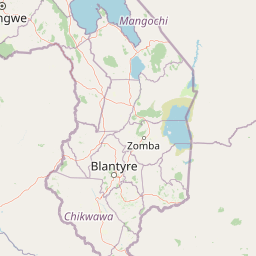
Map view of Liwonde National Park

Use this park location map to pinpoint Liwonde National Park in Malawi, understand its exact geographic position, and read its mapped placement within the surrounding landscape more clearly.

Pigeon | © OpenStreetMap contributors

Location context for Liwonde National Park

Machinga DistrictMangochi DistrictSouthern Region

Visually understand the Shire River corridor, mopane woodlands, and diverse wetland habitats of this Malawian park.

Explore Liwonde National Park Photos: Mapped Landscapes and Protected Area Scenery
Visually explore the diverse protected landscapes of Liwonde National Park, from its vital Shire River corridor to extensive mopane woodlands and savannah ecosystems. This imagery provides crucial context for understanding the park's distinct terrain, conservation efforts, and rich habitat mosaic, supporting deeper geographic discovery.

Several crocodiles resting in shallow water near a riverbank.

An elephant standing among trees and bushes in a dry savanna landscape

Palm trees and dry grassland landscape with a river visible in the distance under a clear sky

Park atlas

Discover other protected landscapes and mapped geography in Southern Malawi and the wider region, comparing similar park characteristics.

Explore National Parks and Protected Areas Near Liwonde National Park, Malawi
After exploring Liwonde National Park, browse other national parks and protected areas across southern Malawi and the adjacent regional geography. Compare different park types, conserved landscapes, and ecological features to broaden your understanding of protected areas in this part of Africa.
National parkMalawi

Lake Malawi National Park: UNESCO Protected Landscape and Endemic Fish Habitat

Discover mapped terrain, island geography, and evolutionary wonders.

Lake Malawi National Park offers unparalleled insight into freshwater biodiversity and landscape dynamics within Malawi's Great Rift Valley. As a UNESCO World Heritage Site, it is celebrated for its spectacular evolutionary radiation of cichlid fish, a phenomenon studied globally. The park's protected territory includes the mountainous Nankumbu Peninsula and thirteen islands, providing a rich context for understanding the interplay between aquatic ecosystems, terrestrial terrain, and unique island geography.

Area
94 km²
Established
1980
IUCN
II
Relief
Mountain
National parkMalawi

Lengwe National Park: Malawi's Protected Landscape Atlas and Geographic Context

Mapped natural terrain and protected area boundaries in Malawi.

Lengwe National Park offers a focused look into Malawi's protected natural areas. As a designated national park, its geographic significance is highlighted through mapped boundaries and an understanding of the surrounding regional terrain. This entry provides essential context for exploring its identity as a protected landscape within southeastern Africa, contributing to a broader atlas of conservation areas.

Area
887 km²
Established
1970
IUCN
II
Climate
Tropical
National park

Kasungu National Park: Protected Landscape and Geographic Atlas of Central Malawi

Explore Miombo woodlands and dambo grasslands across its mapped terrain.

Kasungu National Park is a key protected area in Malawi, offering insights into the geography of Central Malawi's savanna landscapes. This national park, covering over 2,300 square kilometres, is defined by its characteristic Miombo woodland interspersed with dambo grasslands and riverine habitats. Its location near the Zambian border provides a critical conservation corridor, making it an important entity for understanding regional protected land distribution and landscape ecology within the atlas.

Area
2,316 km²
Established
1970
IUCN
II
Relief
Mixed relief
National parkZambia

Lukusuzi National Park: Zambia's Protected National Park Geographic Context

Mapped protected area and regional landscape identity for Lukusuzi.

Gain detailed insights into Lukusuzi National Park, a key protected area in Zambia, through its geographic setting and mapped boundaries. This page provides essential context for understanding the park's landscape character and its significance within the national park atlas. Explore the fundamental protected-area geography of this distinct Zambian natural landscape.

IUCN
II
Access
Access unknown
Scope
Terrestrial
National parkTete Province

Magoe National Park: A National Park in Tete Province for Geographic and Landscape Exploration

Discover the mapped boundaries and regional geography of this protected area.

Magoe National Park serves as a crucial national park within Tete Province, providing a defined space for exploring regional geography and landscape features. This entry focuses on understanding the park's protected status and its mapped territories, offering valuable context for atlas and geographic research. Examine its location and boundaries to appreciate its role as a protected natural landscape within Mozambique.

Area
3,559 km²
Established
2013
Scope
Terrestrial
Water
Major water bodies
Watercolor illustration showing a lake surrounded by grassy areas with trees and mountains in the background
Nature reserveMozambique

Niassa Reserve Nature Reserve: Mozambique's Expansive Protected Wilderness

Mapping the vast miombo woodlands and endemic species.

Niassa Reserve, a sprawling nature reserve in northern Mozambique, represents one of the largest miombo woodland ecosystems on Earth. Its diverse terrain encompasses dense forests, open savannahs, and riparian zones, making it a vital habitat for unique wildlife and a significant landmark in regional geography. The reserve's protected status and immense scale offer unparalleled opportunities for atlas-style exploration of its landscape and conservation importance.

Area
42,000 km²
Established
1954
IUCN
IV
Relief
Mixed relief
National parkZambia

Luambe National Park: Detailed Geographic and Protected Area Atlas Information

Mapped landscape context within Zambia's natural regions.

This section provides an in-depth look at Luambe National Park, detailing its role as a protected area within the diverse geography of Zambia. Users can explore its mapped boundaries and understand its significance within the country's atlas of natural landscapes. The focus is on providing a concrete geographic perspective, essential for understanding how this national park fits into the regional conservation and landscape context of southern Africa.

Area
300 km²
IUCN
II
Relief
Upland
Climate
Tropical
National parkMozambique

Gorongosa National Park: Mozambique National Park with Diverse Rift Valley Ecosystems

Mapped protected area, savanna, and montane rainforest landscapes.

Gorongosa National Park is a premier protected area situated in Mozambique's Great African Rift Valley. This vast national park showcases an extraordinary range of natural landscapes, including extensive floodplains, acacia savannas, and rare montane rainforests within dramatic limestone gorges. Its geographic diversity is matched by its compelling narrative of ecological restoration, making it a significant site for understanding protected land dynamics and regional geography.

Area
3,770 km²
Established
1960
IUCN
II
Relief
Mixed relief

Common questions about visiting, size, designation, and location context for Liwonde National Park

Liwonde National Park FAQs for park facts, access, geography, and protected area context
Find quick answers about Liwonde National Park, including protected-area facts, park geography, trail and visitor context, and how the park fits into its surrounding country and regional landscape.
MoriAtlas Explorer

Continue Your Protected Areas Search Across the Global Atlas

Deepen your exploration by continuing the structured search for national parks and protected areas worldwide. Utilize the comprehensive filtering capabilities to compare different conservation landscapes and refine your understanding of global park geography. Discover more about the distribution and characteristics of protected natural areas.

Global natural geography