Mori Atlas logo
National parkLofotodden National Park

Discover the rugged terrain, protected boundaries, and geographic context of this iconic national park.

Lofotodden National Park: Dramatic Arctic Mountain Landscapes on Norway's Coast

(Lofotodden nasjonalpark)

Lofotodden National Park represents a stunning segment of Norway's Lofotenveggen mountain range, established to protect its dramatic alpine scenery where jagged peaks meet the North Atlantic. This protected area in Nordland county encompasses a unique combination of volcanic and granite mountains, steep coastal cliffs, and adjacent marine environments, offering a rich tapestry for geographic exploration. MoriAtlas provides an atlas-driven view of Lofotodden National Park, highlighting its mapped boundaries and landscape features within the broader regional geography for detailed discovery.

mountain parkscoastal landscapesArctic parksvolcanic landscapesgranite peaksseabird colonies
Illustration of mountainous landscape with green and pink peaks, a lake, rocks, and sandy shore

Lofotodden National Park

National park

Park overview

Structured park overview, official facts, and landscape profile for Lofotodden National Park

Lofotodden National Park park facts, protected area profile, and essential visitor context
Review the core facts for Lofotodden National Park, including designation, size, terrain, visitor scale, habitats, and operating context in one park-focused overview.

About Lofotodden National Park

Lofotodden National Park occupies the southern portion of the dramatic Lofotenveggen mountain wall along the western coast of Moskenesøya, one of the main islands in the Lofoten archipelago of northern Norway. The park encompasses approximately 36 kilometers of terrain extending from the northern islets of the island to the scattered islands off its southwestern coast. The landscape is defined by a spectacular mountain range of jagged, ancient peaks composed of volcanic rocks and granite that rise steeply from the Arctic seas, creating one of Europe's most dramatic mountain-coastal interfaces. Beyond the mountain peaks, the protected area includes coastal terrain with bays, small islets, and the Lofotodden Nature Reserve at the southwestern tip, which encompasses the island of Sørholmen and surrounding smaller islets important for seabird nesting. The park was established to preserve a landscape where natural processes have operated with minimal human interference, protecting both the geological and ecological values that make this Arctic archipelago unique. The name Lofotodden refers to the historical designation for this distinctive landscape at the southern end of the Lofoten mountains.

Quick facts and research context for Lofotodden National Park

Lofotodden National Park spans 99 km² along the western coast of Moskenesøya in Lofoten, Nordland county, Norway, just north of the Arctic Circle. The park protects the southern segment of the 160-kilometer Lofotenveggen mountain range, featuring peaks between 500 and 1,029 meters in elevation. The terrain is extremely rugged, composed of ancient volcanic and granite rock formations. The park includes coastal bays, small islands, and the Lofotodden Nature Reserve at the southwestern tip, which serves as important seabird nesting habitat. The park was officially opened in June 2019 following its designation in 2018.

Park context

Deeper park guide and search-rich context for Lofotodden National Park

Lofotodden National Park history, landscape, wildlife, and travel context
Explore Lofotodden National Park through its history, landscape character, ecosystems, wildlife, conservation priorities, cultural context, and seasonal travel timing in a structured park guide built for atlas discovery and search intent.

Why Lofotodden National Park stands out

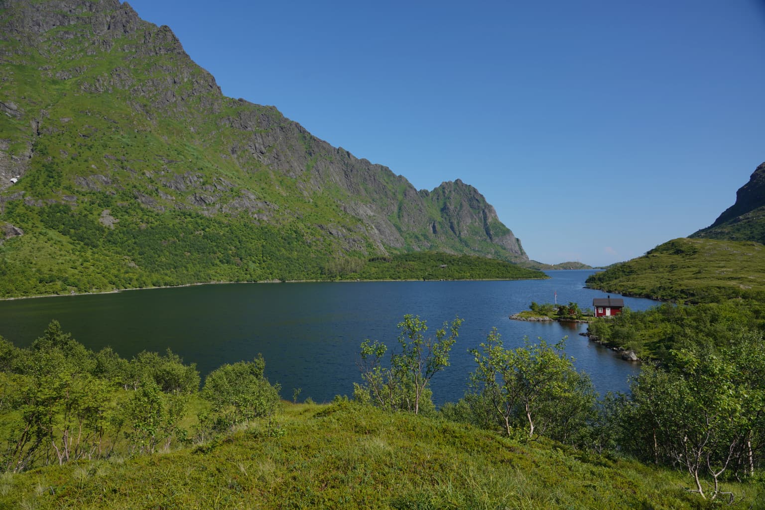
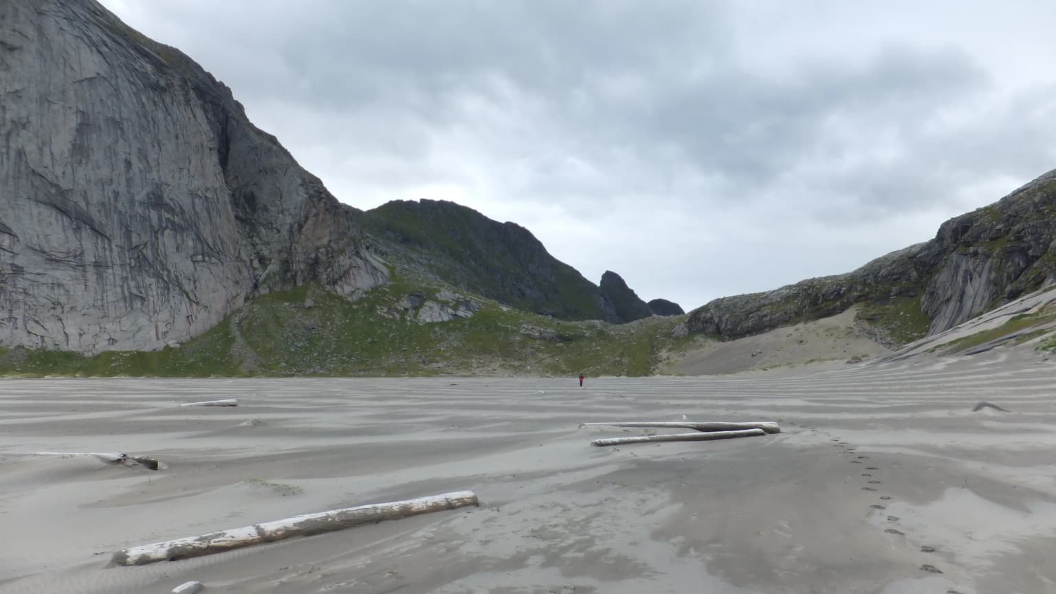
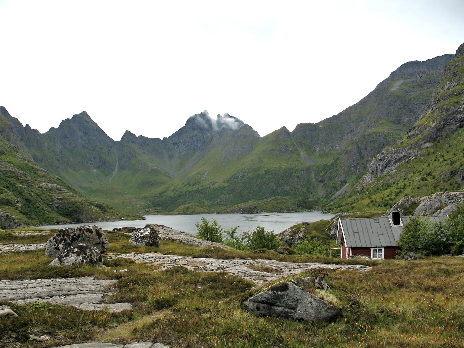
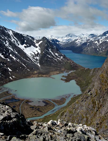
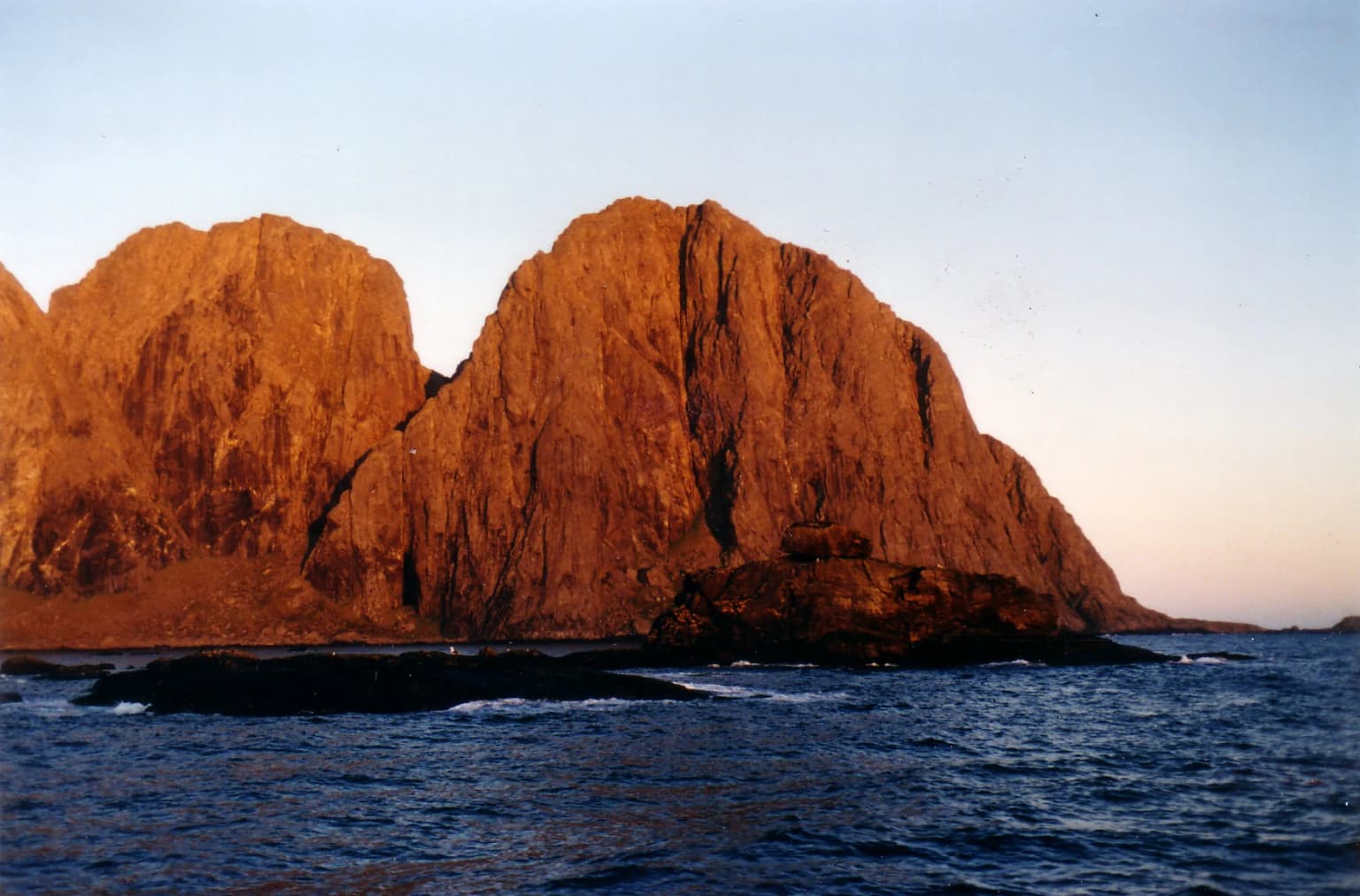
Lofotodden is best known for its spectacular alpine scenery where dramatic mountain peaks rise directly from the North Atlantic coast, creating one of Norway's most recognizable and photographed landscapes. The Lofotenveggen, a nearly continuous wall of mountains stretching 160 kilometers along the archipelago's western edge, reaches its most dramatic expression within this park. The combination of sharp granite and volcanic peaks, including the prominent Hermannsdalstinden, with coastal features like Bunesstrand sandy beach and the sheltered waters of Ågvatnet lake, creates an exceptional mountain-and-sea environment. The park also protects significant seabird nesting colonies and rare coastal dune systems that are unusual this far north.

A large calm lake surrounded by steep green mountains and dense vegetation under a clear blue sky
Ågvatnet Lake within Lofotodden National Park, Norway, surrounded by forested mountain slopes under a clear blue sky

Lofotodden National Park history and protected-area timeline

Lofotodden National Park was formally established on June 22, 2018, making it one of Norway's newer national parks. The park was officially opened by Climate and Environment Minister Ola Elvestuen on June 9, 2019. The creation of the park fulfilled long-standing conservation goals to protect the natural, cultural, and historical values of the Lofotenveggen landscape. The park's name derives from the traditional regional name for this distinctive area at the southern end of the Lofoten mountain range. While the protected area itself has been kept largely free from major development, the adjacent Stokkvika valley was excluded from the park boundaries due to its historical human occupation, with documented residency dating to 1634 and later use as a military facility during World War II and into the 1960s.

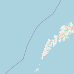
Lofotodden National Park landscape and geographic character

The landscape of Lofotodden National Park is dominated by the imposing Lofotenveggen mountain wall, a nearly continuous ridge of rugged peaks that forms the backbone of the Lofoten archipelago's western coast. The park protects the southern approximately 160-kilometer segment of this mountain range, where peaks rise dramatically from sea level to elevations between 500 and 1,029 meters. The highest peak within the park is Hermannsdalstinden, which at 1,029 meters above sea level is the highest point on Moskenesøya island and among the most prominent mountains in northern Norway. The terrain is composed of ancient volcanic rocks and granite that have been shaped by glacial processes, creating the characteristic sharp ridges, steep cliffs, and jagged summits that define the Lofoten silhouette. Between the mountain peaks, the terrain includes coastal bogs, rubble forest areas, and sand dunes that meet the North Atlantic at the park's western edge. The park encompasses several bays and inlets including portions of the coastal waters, as well as smaller islands and islets at the southwestern tip where the Lofotodden Nature Reserve provides additional protection.

Bunes Beach in Lofotodden National Park, Norway, featuring sandy shore with driftwood, distant mountains, and a single figure under overcast sky
Sandy beach at Bunes with mountainous backdrop in Lofotodden National Park, Norway

Lofotodden National Park ecosystems, habitats, and plant life

The ecological character of Lofotodden National Park reflects the unique convergence of Arctic alpine and North Atlantic coastal environments. The park protects a remarkable diversity of habitat types within a relatively limited area, including rubble forests, coastal bogs, cliffed coastlines, and sand dune systems that are unusual in this northern latitude. The coastal areas and offshore islands support significant seabird populations, with the Lofotodden Nature Reserve at the southwestern tip serving as particularly important nesting grounds. The park's vegetation includes northern birch woodland in sheltered valleys and more open heath communities on exposed slopes. The combination of relatively low human impact and the variety of microhabitats created by the mountain-coastal interface has allowed for the persistence of specialized plant and fungal species adapted to these harsh but ecologically diverse conditions.

Lake Ågvatnet surrounded by green mountains and rocky terrain, with a small house on the shore
Lake Ågvatnet with surrounding mountains and a small house in Lofotodden National Park, Norway

Lofotodden National Park wildlife and species highlights

Lofotodden National Park supports several species of conservation significance, particularly among seabirds that nest on the coastal cliffs and islands. The protected area provides habitat for black guillemot and European shag, both species of concern in the broader Nordic region. Various gull species also utilize the coastal islands and cliff habitats for nesting. The diverse habitats within the park support a range of terrestrial wildlife typical of northern Norwegian mountain and coastal environments, though the primary conservation significance lies in the seabird colonies and the species that depend on the coastal-marine interface. The park's position along the eastern Atlantic flyway also makes it significant for migratory bird populations that pass through the Lofoten archipelago seasonally.

Turquoise lake surrounded by rocky mountains with patches of snow, viewed from a high vantage point with a partly cloudy sky
Mountainous landscape view with turquoise lake and snow-capped peaks under a partly cloudy sky

Lofotodden National Park conservation status and protection priorities

Lofotodden National Park was created specifically to preserve the outstanding natural, cultural, and historical values of a landscape that has remained relatively unaffected by human development. The protection encompasses the entire mountain-coastal ecosystem, from the alpine peaks through the coastal zones to the surrounding marine areas. The park preserves not only the dramatic scenery that defines the Lofoten archipelago but also the ecological processes that sustain its biodiversity, including the seabird colonies at the Lofotodden Nature Reserve and the unusual coastal dune and bog habitats. The designation recognizes that this landscape represents one of northern Europe's most significant mountain-coastal protected areas, where natural dynamics continue largely unimpeded across a spectrum of Arctic and boreal habitats.

Lofotodden National Park cultural meaning and human context

The landscape of Lofotodden has been part of the human history of the Lofoten archipelago for centuries, though the park area itself has remained relatively sparsely populated due to its rugged terrain. The adjacent Stokkvika valley, excluded from the park boundaries, contains evidence of continuous habitation dating to at least 1634, illustrating the long history of human presence in even the most challenging terrain of this region. The traditional name Lofotodden reflects the historical regional identity of this distinctive landscape at the southern end of the Lofoten mountains. During World War II and the post-war period, certain areas surrounding the park were used for military purposes, but the core mountain and coastal areas preserved their wilderness character and were ultimately protected through national park designation.

Large rocky mountain cliffs rising from the sea, illuminated by golden light during what appears to be sunrise or sunset
Rocky headland of Lofotodden National Park illuminated by golden hour light

Top sights and standout views in Lofotodden National Park

Lofotodden National Park offers exceptional mountain scenery where the dramatic Lofotenveggen rises directly from the North Atlantic, with peaks like Hermannsdalstinden providing iconic Arctic alpine silhouettes. The park protects unusual coastal features including the sandy Bunesstrand beach on the western coast and the tranquil Lake Ågvatnet nestled beneath towering peaks. The Lofotodden Nature Reserve at the southwestern tip safeguards important seabird nesting colonies on islands like Sørholmen. Hiking trails cross the mountain range, including routes from Vinstad to Bunesstrand and from the village of Å along Lake Ågvatnet to the western coast, offering access to one of Norway's most spectacular protected mountain landscapes.

Best time to visit Lofotodden National Park

The summer months of June through August offer the most accessible conditions for exploring Lofotodden National Park, with relatively mild temperatures, long daylight hours, and snow-free mountain trails. The midnight sun period around the summer solstice provides exceptional lighting for photography and extended hiking opportunities. Autumn (September through October) brings the first snow to higher elevations and creates dramatic light conditions as the landscape transitions toward winter. Winter conditions are severe, with snow cover on the mountains and limited access, though the stark alpine scenery under winter conditions offers a different but equally compelling experience for those prepared for Arctic conditions. The shoulder seasons of late spring and early autumn typically offer fewer visitors while still providing reasonable access to the park's main attractions.

Park location guide

Geography guide, regional context, and park location map for Lofotodden National Park

Lofotodden National Park park geography, regions, and map view in Norway
Understand where Lofotodden National Park sits in Norway through a broader geographic reading of the surrounding landscape, nearby location context, and its mapped position within the national park landscape.

How Lofotodden National Park fits into Norway

Norway, officially the Kingdom of Norway, is a Nordic country in Northern Europe located on the Scandinavian Peninsula. It encompasses mainland Norway, the Arctic islands of Svalbard and Jan Mayen, and maintains dependencies including Bouvet Island and Antarctic claims. The country has a population of about 5.6 million and is bordered by Sweden, Finland, and Russia. Norway is a unitary parliamentary constitutional monarchy with Oslo as its capital and largest city.

Wider geography shaping Lofotodden National Park in Norway

Norway occupies the western and northern portions of the Scandinavian Peninsula in Northern Europe. The country shares a long eastern border with Sweden, and borders Finland and Russia to the northeast. Norway has an extensive coastline facing the Skagerrak, North Sea, Norwegian Sea, and Barents Sea. The terrain is predominantly mountainous with numerous fjords along the coastline.

Map view of Lofotodden National Park

Use this park location map to pinpoint Lofotodden National Park in Norway, understand its exact geographic position, and read its mapped placement within the surrounding landscape more clearly.

Pigeon | © OpenStreetMap contributors

Location context for Lofotodden National Park

Flakstad MunicipalityMoskenes MunicipalityNordland

Visually explore the park's dramatic mountain peaks, rugged coastal terrain, and preserved Arctic habitats.

Lofotodden National Park Photos: Exploring Norway's Arctic Mountain and Coastal Scenery
Explore a curated gallery showcasing the majestic landscapes and unique scenery of Lofotodden National Park, from its iconic Lofotenveggen mountain wall to its dramatic Arctic coastal features. These images provide essential visual context, revealing the park's distinct protected-area character, diverse habitats, and unparalleled geological terrain, offering a deeper appreciation of this Norwegian natural wonder.

A large calm lake surrounded by steep green mountains and dense vegetation under a clear blue sky

Aerial view of multiple fjords surrounded by mountainous terrain in Lofoten Islands, Norway

Bunes Beach in Lofotodden National Park, Norway, featuring sandy shore with driftwood, distant mountains, and a single figure under overcast sky

Lake Ågvatnet surrounded by green mountains and rocky terrain, with a small house on the shore

Turquoise lake surrounded by rocky mountains with patches of snow, viewed from a high vantage point with a partly cloudy sky

Close-up view of green moss-like vegetation growing on a rock with lichen, surrounded by grass and small plants

Large rocky mountain cliffs rising from the sea, illuminated by golden light during what appears to be sunrise or sunset

Park atlas

Compare the dramatic mountain and coastal landscapes of other protected areas throughout the Lofoten archipelago and wider northern Norway.

Compare Related National Parks and Protected Areas Near Lofotodden National Park
Explore other national parks and protected areas across the Lofoten archipelago and wider northern Norway, featuring diverse mountain ranges and striking coastal landscapes similar to Lofotodden National Park. Comparing these regional protected areas reveals distinct geographic patterns and conservation efforts, offering comprehensive atlas-style understanding of Arctic environments.
National parkNordland

Sjunkhatten National Park: Norway's Protected National Park Identity and Geographic Atlas

Mapped landscape context and regional geography details.

Explore the structured geographic data and protected landscape context for Sjunkhatten National Park, a significant national park in Nordland, Norway. This page provides detailed insights into its mapped boundaries and regional setting, offering an atlas-driven view of its natural terrain. Understand how this protected area contributes to the broader geography of Norway through factual, map-oriented discovery.

Area
417.5 km²
Established
2010
IUCN
II
Relief
Mountain
Watercolor illustration showing mountains, a lake, and rolling hills
National parkNordland

Møysalen National Park: Coastal Alpine Protected Landscape in Nordland, Norway

Mapped boundaries, dramatic terrain, and coastal ecosystems.

Møysalen National Park offers a compelling study in coastal alpine geography, situated within Nordland county, Norway. This protected area is renowned for its dramatic mountain scenery where peaks plunge directly into the sea and deep fjords. The park's 51 square kilometres encompass a unique ecological transition from alpine summits to sea level, featuring jagged peaks, sheltered valleys with birch forests, and coastal wetlands. Explore the mapped landscape of this distinctive Norwegian national park and understand its place in regional geography and protected land networks.

Area
51 km²
Established
2003
IUCN
II
Relief
Mountain
National park

Láhko National Park: Northern Norway's Protected Arctic Landscape and Geographic Atlas Entry

Mapped boundaries and terrain of a key Finnmark national park.

Láhko National Park is a significant protected area within Norway's Finnmark region, representing a vast expanse of sub-Arctic wilderness and characteristic tundra ecosystems. This park serves as a crucial element in the atlas of northern European protected lands, offering insights into the geographic features and ecological integrity of high-latitude environments. Explore Láhko National Park through MoriAtlas to understand its landscape context, mapped terrain, and its role in preserving Nordic wilderness.

Watercolor illustration showing mountains, a river, and forests in a landscape
National parkNordland

Rago National Park: Northern Norway's Protected Mountain Wilderness and Transboundary Atlas

Explore the mapped terrain and unique landscape context of this significant protected area.

Rago National Park is a protected national park in Nordland, Norway, recognized for its challenging mountainous terrain and its crucial role as part of a vast transboundary protected area complex spanning into Sweden. The park's landscape features alpine lakes and glaciers, offering a stark representation of northern Scandinavian mountain wilderness. Understanding Rago National Park provides insight into regional conservation efforts and the geographic significance of large-scale protected lands in Europe.

Area
171 km²
Established
1971
IUCN
II
Relief
Mountain
Watercolor illustration showing mountains, a river, and colorful landscape regions
National park

Saltfjellet, Svartisen National Park: Glacial Terrain & Protected Arctic Wilderness

Norway's vast national park with Svartisen glacier and unique flora.

Saltfjellet, Svartisen National Park spans over 2,100 square kilometers of diverse protected wilderness in Northern Norway. Renowned for Svartisen, Scandinavia's second-largest glacier, its landscape transitions from coastal influences to alpine plateaux. The park's calcareous bedrock supports a rich flora, rare in the region, contributing to its distinct geographic identity. Explore the mapped boundaries and natural terrain of this significant protected landscape.

Area
2,192 km²
Established
1989
IUCN
II
Relief
Mixed relief
Watercolor illustration of a landscape with rolling hills, a river, and trees
National parkNordland

Junkerdal National Park: Protected Arctic-Alpine Landscape in Nordland, Norway

Explore mapped boundaries and unique geographic context.

Delve into Junkerdal National Park, a significant protected area within Nordland county, Norway. This national park is celebrated for its rich arctic-alpine flora, including rare plant species that thrive at their southernmost European range. The varied landscape, shaped by glacial activity, features dramatic mountain valleys and alpine plateaus, offering a distinct geographic profile. Understand its protected status and mapped terrain, providing a critical point of discovery for regional landscape context.

Area
682 km²
Established
2004
IUCN
II
Relief
Mountain
Watercolor illustration of a winding river through a green landscape with distant mountains
National parkNorrbotten County

Padjelanta National Park: Sweden's Largest National Park Protected Plateau Landscape

Explore subarctic terrain, large lakes, and Laponia World Heritage Site geography.

Padjelanta National Park, situated in Norrbotten County, is Sweden's largest national park. It features a distinctive subarctic plateau ecosystem centered around two vast lakes, offering a starkly open landscape compared to adjacent alpine areas. This protected area is renowned for its exceptional botanical and lichen diversity, a vital part of the Laponia World Heritage Site. Users can explore its mapped geography, unique terrain, and the cultural significance of this expansive arctic wilderness.

Area
1,984 km²
Established
1963
IUCN
II
Relief
Highland
Watercolor illustration of a mountainous landscape with a river, grass, and distant hills
National parkNorrbotten County

Sarek National Park: Mapping Sweden's Rugged Alpine Wilderness and Glacial Terrain

Explore the mapped geography of Norrbotten County's largest alpine national park.

Sarek National Park represents the heart of Sweden's alpine wilderness, a protected landscape defined by its towering mountain peaks, expansive glaciers, and deeply carved glacial valleys. Situated in Norrbotten County, the park's geography is characterized by a remote and rugged terrain, making it a prime destination for understanding high-altitude natural environments through mapped context. Discover the unique contours of this iconic national park and its place within the broader regional geography of Swedish Lapland.

Area
1,970 km²
Established
1909
IUCN
II
Relief
Mountain

Common questions about visiting, size, designation, and location context for Lofotodden National Park

Lofotodden National Park FAQs for park facts, access, geography, and protected area context
Find quick answers about Lofotodden National Park, including protected-area facts, park geography, trail and visitor context, and how the park fits into its surrounding country and regional landscape.
MoriAtlas Explorer

Continue Your Protected Areas Search Across the Global Atlas

Deepen your exploration by continuing the structured search for national parks and protected areas worldwide. Utilize the comprehensive filtering capabilities to compare different conservation landscapes and refine your understanding of global park geography. Discover more about the distribution and characteristics of protected natural areas.

Global natural geography