Mori Atlas logo
National parkSarek National Park

Discover the rugged terrain of Norrbotten County's premier alpine national park.

Sarek National Park: Mapping Sweden's Untamed High-Alpine Protected Landscape

(Sareks nationalpark)

Sarek National Park stands as Sweden's quintessential high-alpine protected area, a vast expanse of dramatic mountain massifs, deep glacial valleys, and remote plateaus. Located within Norrbotten County, this national park offers an unparalleled glimpse into one of Europe's most rugged and remote natural landscapes. Through MoriAtlas, users can explore the mapped boundaries and geographic context of Sarek, understanding its significance as a core element of Sweden's arctic wilderness and its role within the broader regional geography.

Alpine EnvironmentGlaciersMountain PeaksSwedish LaplandWilderness AreaWorld Heritage Site
Illustration of mountain range with snow patches, river valley, coniferous trees, and flowers under a sunlit sky

Sarek National Park

National park

Park overview

Structured park overview, official facts, and landscape profile for Sarek National Park

Sarek National Park park facts, protected area profile, and essential visitor context
Review the core facts for Sarek National Park, including designation, size, terrain, visitor scale, habitats, and operating context in one park-focused overview.

About Sarek National Park

Sarek National Park represents the crown jewel of Swedish mountain protection, established in 1909 as part of Sweden's pioneering national park system—among the first created in Europe. The park occupies a roughly circular area of nearly 2,000 square kilometres in the heart of Lapland, situated north of the Arctic Circle in Jokkmokk Municipality. The landscape is dominated by the Sarek mountain district, a compact concentration of alpine terrain that differs from the more extended mountain chains found elsewhere in Scandinavia. Six of Sweden's thirteen peaks exceeding 2,000 metres rise within the park's boundaries, with Sarektjåkkå reaching 2,089 metres as the nation's second-highest summit. Approximately 100 glaciers dot the terrain, making Sarek one of Sweden's most glacier-rich areas. The Pårtejekna glacier at 11 square kilometres is the largest in the park. The park forms a contiguous protected landscape with neighbouring Stora Sjöfallet and Padjelanta national parks, together comprising about 5,500 square kilometres of near-pristine mountain environment. This tri-park complex was inscribed as the Laponian Area World Heritage Site in 1996, recognizing both the outstanding natural values and the traditional Sami cultural landscape. The lack of development within the park—absent marked trails, mountain huts, or visitor infrastructure—preserves the wild character that has defined Sarek since its protection, offering a rare experience of genuine Arctic wilderness.

Quick facts and research context for Sarek National Park

Sarek National Park lies in Norrbotten County, Swedish Lapland, north of the Arctic Circle and approximately 50 kilometres from the Norwegian border. The park covers 1,970 km² with a roughly circular shape averaging 50 kilometres in diameter. It was established in 1909 alongside eight other Swedish national parks—the first in Europe. The park contains six of Sweden's thirteen 2,000-metre peaks, about 200 mountains exceeding 1,800 metres, and over 100 glaciers. The Rapa River is the main watercourse, originating from Sarektjåkkå's glaciers and carrying significant sediment loads. The park is managed by Sweden's Environmental Protection Agency (Naturvårdsverket) and forms part of the Natura 2000 European Union protected areas network.

Park context

Deeper park guide and search-rich context for Sarek National Park

Sarek National Park history, landscape, wildlife, and travel context
Explore Sarek National Park through its history, landscape character, ecosystems, wildlife, conservation priorities, cultural context, and seasonal travel timing in a structured park guide built for atlas discovery and search intent.

Why Sarek National Park stands out

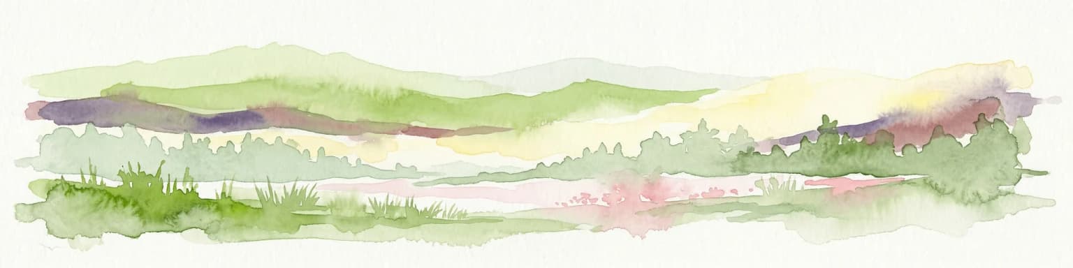
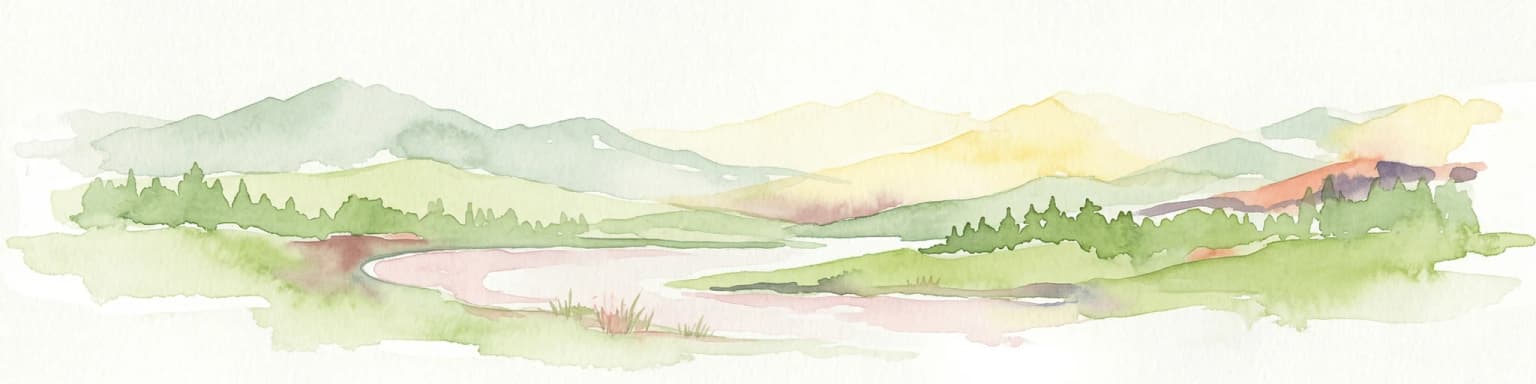
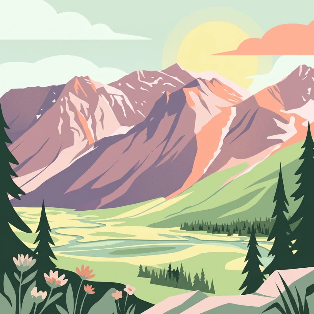
Sarek is renowned as Sweden's premier high-alpine wilderness, protecting a dramatic landscape of craggy peaks, glacial valleys, and remote plateaus that has been described as the country's last great wilderness. The park contains six of Sweden's thirteen peaks exceeding 2,000 metres, with Sarektjåkkå standing as the nation's second-highest mountain. The Rapa Valley (Rapadalen) is considered one of Europe's most spectacular valley views, and the Skierfe summit offers panoramic vistas over the ice-covered glacial through valleys. The Laitaure river delta is an emblematic landscape feature. The park's absence of marked trails, mountain huts, and minimal bridges creates a genuine wilderness experience that attracts experienced hikers and mountaineers seeking solitude in one of Scandinavia's most unspoiled alpine environments.

Aerial photograph of a river delta with winding waterways, green valleys, and mountainous terrain in Sarek National Park
Aerial view of Rapadalen delta in Sarek National Park, Sweden

Sarek National Park history and protected-area timeline

Sarek's human history stretches back approximately 8,000 years to when the first inhabitants arrived following the retreat of inland seas after the last glaciation. These early hunter-gatherers, ancestors of the Sami people, lived primarily from reindeer and regarded the mountains as sacred spaces. Several locations within the park, particularly Mount Skierfe, served as sieidi—Sami places of worship where offerings such as reindeer antlers were made. The Sami developed a system of transhumance, spending winters on the plains and moving to mountain pastures in summer, using Sarek primarily as a travel corridor between different seasonal grazing grounds. Swedish scientific exploration began with Carl von Linné's 1732 expedition to Lapland, though systematic study came later. French explorer Charles Rabot achieved the first recorded ascent of Sarektjåkkå in 1881. The most significant scientific figure was Axel Hamberg, a mineralogist and geographer who began studying the region in 1895 and continued until his death in 1931, creating detailed maps and establishing the Pårte Scientific Station. Hamberg's advocacy was instrumental in the park's establishment in 1909. The mid-20th century brought hydroelectric development pressures, leading to the 1961 "Sarek Peace" agreement that protected the park from dam construction. In 1996, Sarek became part of the Laponian Area World Heritage Site, and in 2013, Sami rights to reindeer husbandry were restored throughout the entire park.

Sarek National Park landscape and geographic character

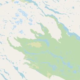
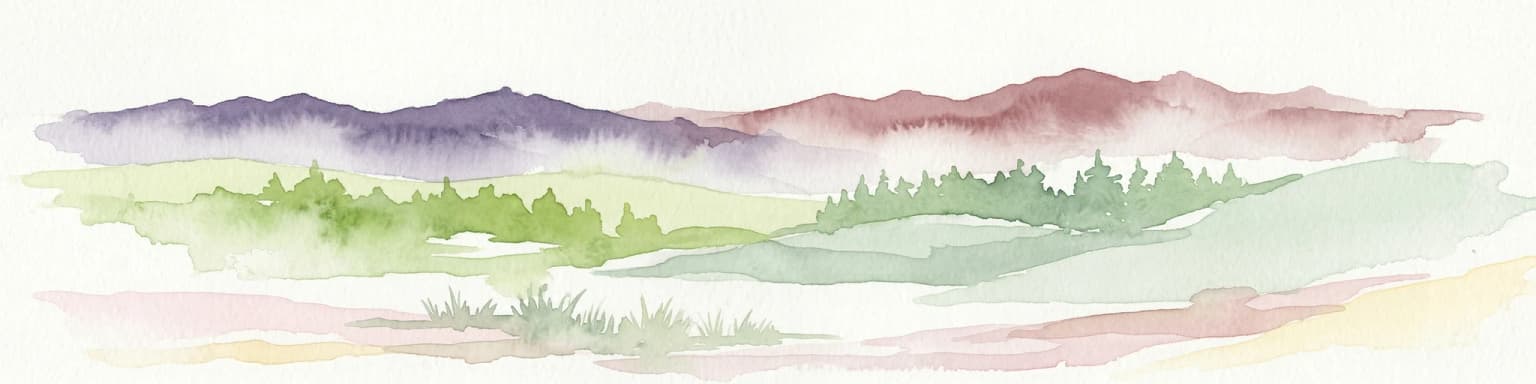
The topography of Sarek National Park is exceptionally dramatic, representing the most mountainous and alpine region in Sweden. The landscape comprises three principal elements: massive mountain massifs, deep glacial valleys, and high-elevation plateaus. The park contains 19 summits exceeding 1,900 metres and approximately 200 mountains over 1,800 metres, of which 82 bear names. The primary massifs include Sarektjåkkå (2,089m), Pårte (2,005m), Piellorieppe (1,978m), Ålkatj (1,974m), Äpar (1,914m), Skårki (1,842m), and Ruotes (1,804m). The valleys are the park's most distinctive feature, with the Rapa Valley (Rapadalen) being the largest at 40 square kilometres, including tributary valleys such as Sarvesvagge, Kuopervagge, and Ruotesvagge. The high plateaus of Ivarlako and Luottolako cover 45 square kilometres at elevations between 1,200 and 1,400 metres. The lowest point in the park lies near Lake Rittakjaure at 477 metres in the southwest. The Rapa River (Rapaätno) originates from the glaciers of Sarektjåkkå and flows through the park, creating the celebrated Laitaure delta where it enters Lake Laitaure. The river is fed by thirty glaciers and carries enormous sediment loads—up to 10,000 metric tons daily in summer—giving it a distinctive grey-green colour.

Snow-covered mountain peaks with patches of green vegetation, distant mountain ranges under a partly cloudy sky
Sadelberget mountain peak in Sarek National Park

Sarek National Park ecosystems, habitats, and plant life

Sarek National Park lies within the Scandinavian Montane Birch Forest and Grasslands ecoregion, with a minor section in the Scandinavian and Russian taiga. The park's ecological character is defined by pronounced altitudinal zonation across distinct vegetation zones. The montane zone, found only at lower elevations below approximately 500 metres, features old-growth coniferous forests of Scots pine and Norway spruce with undergrowth of mosses, lichens, and Vaccinium species. The subalpine birch forest zone is exceptional in its density and richness, with mountain birch forming extensive woodlands that gradually replace conifers with increasing altitude. The tree line varies considerably across the park, from 600 metres in the Tjoulta valley to over 800 metres in the Rapa Valley. Above the tree line, the alpine zone supports heath vegetation with crowberry, dwarf willows, and lichens, transitioning to sparse polar desert at the highest elevations where only 18 plant species survive above 1,500 metres. Approximately 380 species of vascular plants have been recorded in the park, alongside rich communities of mosses and lichens. The humid zones, though less extensive than in surrounding regions, support diverse flora including globeflower, kingcup, and twoflower violet.

Snow-capped mountain peaks with patches of green vegetation in a valley, showing the alpine landscape of Sarek National Park
Kuopervagge valley in Sarek National Park, Sweden

Sarek National Park wildlife and species highlights

Sarek supports a notable community of large mammals and Arctic-adapted species. The brown bear is particularly frequent, especially in the Rapa Valley and around the lakes of Rittak and Laitaure, and the park serves as an important habitat for this species. The Eurasian lynx, classified as endangered in Sweden, is found throughout the subalpine forests. The wolverine maintains territories in the alpine zone and is classified as endangered in Sweden with approximately 360 individuals nationwide. The Arctic fox, critically endangered with only about 50 individuals remaining in Sweden, inhabits the higher elevations and the park remains one of its last sanctuaries. The gray wolf, also critically endangered in Sweden, was represented by the country's last remaining wild wolf in the park during the 1970s, and the population has since grown. Reindeer, both wild and semi-domesticated, graze in the subalpine and alpine zones as part of traditional Sami husbandry. Moose are abundant in the forested areas. The bird community includes species such as the Ural owl, Eurasian three-toed woodpecker, willow warbler, bluethroat, willow ptarmigan, rock ptarmigan, and snowy owl. Arctic char inhabit the lakes and rivers.

Snow-covered mountain peaks and glaciers in Sarek National Park, Sweden
Aerial view of Ryggåsberget mountain range with glaciers in Sarek National Park

Sarek National Park conservation status and protection priorities

Sarek National Park holds exceptional conservation significance as one of Europe's oldest protected areas and part of the Laponian Area World Heritage Site, inscribed in 1996 as a mixed cultural and natural site spanning 9,400 square kilometres. The park is also part of the European Union's Natura 2000 network. The primary conservation rationale, as stated in the original 1909 establishment protocols, was to preserve a high mountain landscape in its natural state. The 1961 "Sarek Peace" agreement specifically prohibited hydroelectric development within the park and on designated "national rivers," a significant achievement given the extensive dam-building that occurred elsewhere in northern Sweden during the mid-20th century. The park protects critical habitat for several endangered species, including the gray wolf, Arctic fox, and wolverine. However, conservation and Sami reindeer husbandry rights sometimes conflict, particularly regarding wolf predation on reindeer and concerns about snowmobile disturbance affecting pregnant reindeer. The 2007 management plan proposes expanding the park to include the Laitaure Delta and Tjuoltadalen Valley, pending World Heritage consideration.

Sarek National Park cultural meaning and human context

Sarek lies within the traditional territory of the Sami people, who have inhabited the region for thousands of years following the retreat of the inland seas. The Sami place names throughout the park—tjåkkå for mountain, vagge for valley, jåkkå for stream, and ätno for river—reflect this deep cultural connection to the landscape. The mountains held religious significance for the Sami, with numerous sieidi (sacred places) used for offerings and ceremonies, particularly at Mount Skierfe. Traditional Sami transhumance involved moving between winter pastures on the plains and summer grazing in the mountains, primarily using Padjelanta for summer pasture while Sarek served as a travel corridor. Although Sami rights were progressively restricted following the park's establishment, the 2013 restoration of full reindeer husbandry rights throughout the park marked an important reversal. The Sami communities of Sirkas, Jåhkågaskka, and Tuorpons retain grazing rights, and motorised transport for reindeer management is permitted. The Alkavare chapel, built in 1788 for summer-reindeer herding Sami, remains in use by the Church of Sweden.

Wide view of snow-capped mountains and a glacier in Sarek National Park, Sweden
Snow-covered mountain peaks and a glacier in Sarek National Park, Sweden

Top sights and standout views in Sarek National Park

Sarek protects one of Scandinavia's most dramatic high-alpine landscapes, with six of Sweden's highest peaks, over 100 glaciers, and deep glacial valleys creating a wilderness of exceptional rugged beauty. The Rapa Valley (Rapadalen) is considered one of Europe's finest valley views, while the Skierfe summit offers sweeping panoramas over the ice-covered landscape. The park contains approximately 100 glaciers, including the 11-square-kilometre Pårtejekna, and the Rapa River carries immense sediment loads that create the striking Laitaure delta. The absence of marked trails, mountain huts, or bridges ensures a genuine wilderness experience for experienced hikers. Sarek forms part of the Laponian Area World Heritage Site, recognized for both natural and cultural values. The park supports significant populations of brown bears, Eurasian lynx, wolverines, Arctic foxes, and gray wolves—the latter representing Sweden's last wild wolves. The Pårte Scientific Station, built in the early 1900s by Axel Hamberg, stands as a historic landmark of early Arctic research.

Wide view of a mountain landscape with a blue lake in the valley, snow patches on rocky peaks, and clear sky
Mountain landscape in Sarek National Park with snow-capped peaks and a blue lake

Best time to visit Sarek National Park

The summer season from June to September offers the most accessible conditions for hiking in Sarek, though the weather remains highly unpredictable and the park is among the wettest areas in Sweden. July typically sees the highest water levels in streams due to glacier melt, making early morning fordings safer. The brief Arctic summer allows hikers to experience the midnight sun phenomenon at higher latitudes. Winter visits are extremely challenging and dangerous due to the lack of trails, extreme avalanche risk from steep valley slopes, and minimal daylight. Autumn can bring stable weather but rapidly shortening days. The park's heavy rainfall means hikers must be prepared for all conditions regardless of the season, and the absence of any visitor infrastructure within the park demands complete self-sufficiency.

Park location guide

Geography guide, regional context, and park location map for Sarek National Park

Sarek National Park park geography, regions, and map view in Sweden
Understand where Sarek National Park sits in Sweden through a broader geographic reading of the surrounding landscape, nearby location context, and its mapped position within the national park landscape.

How Sarek National Park fits into Sweden

Sweden, formally the Kingdom of Sweden, is a highly developed Nordic country on the Scandinavian Peninsula in Northern Europe. With a population of 10.6 million and an area of 450,295 km², it is the largest Nordic country by both area and population. Sweden is a constitutional monarchy with Stockholm as its capital and largest city, known for its advanced economy, social welfare system, and membership in the European Union and NATO.

Wider geography shaping Sarek National Park in Sweden

Sweden occupies the eastern portion of the Scandinavian Peninsula in Northern Europe. It borders Norway to the west and north, Finland to the east, and shares a maritime border with Denmark to the southwest across the Øresund. The country has an extensive coastline along the Baltic Sea and Gulf of Bothnia, dotted with thousands of islands. The terrain varies from mountainous regions in the northwest to low-lying coastal areas and inland lakes in the south and central parts.

Map view of Sarek National Park

Use this park location map to pinpoint Sarek National Park in Sweden, understand its exact geographic position, and read its mapped placement within the surrounding landscape more clearly.

Pigeon | © OpenStreetMap contributors

Location context for Sarek National Park

Norrbotten County

Visual Guide to Sarek's Glacial Valleys, Towering Peaks, and Arctic Habitats

Sarek National Park Photos: Explore Alpine Landscapes and Wilderness Scenery
Explore curated Sarek National Park imagery to visually understand its dramatic alpine landscapes, towering mountain peaks, and deep glacial valleys. These photographs offer a comprehensive overview of the park's rugged terrain, unique habitats, and protected-area character within Swedish Lapland.

Aerial photograph of a river delta with winding waterways, green valleys, and mountainous terrain in Sarek National Park

A panoramic view of Sarek National Park featuring rugged mountain peaks with patches of snow, a winding river through a green valley, and a clear blue sky

Snow-covered mountain peaks with patches of green vegetation, distant mountain ranges under a partly cloudy sky

Snow-capped mountain peaks with patches of green vegetation in a valley, showing the alpine landscape of Sarek National Park

Snow-covered mountain peaks and glaciers in Sarek National Park, Sweden

Aerial view of mountainous terrain with multiple labeled peaks including Tjäkkok, Ålkaj, Ruotes, Sarektjäkko, Pärte, Piellorieppe, Skärki, and Åhpar

Wide view of snow-capped mountains and a glacier in Sarek National Park, Sweden

Wide view of a mountain landscape with a blue lake in the valley, snow patches on rocky peaks, and clear sky

Wide landscape of Sarek National Park showing Skårki massif with winding river, green valleys, and snow-capped mountains under clear blue sky

Snow-covered mountain peaks and glaciers in a mountainous landscape with rocky terrain in the foreground

Panoramic view of snow-capped mountains and rocky valley in Sarek National Park, Sweden

Snow-covered mountain peaks with glaciers and rocky ridges under a partly cloudy sky

Wide mountain valley with green and brown terrain, rocky peaks with snow patches, and clear blue sky

Aerial view of a mountainous valley with patches of snow, a winding river, and surrounding peaks

Mountainous landscape with rocky peaks, snow patches, valley, and lake in Sarek National Park

A meadow with wildflowers and trees in the foreground, mountain with snow patches in the background under a clear blue sky

Park atlas

Uncover the surrounding regional geography of Sweden's high-alpine protected landscapes, tracing glacial valleys and mountain massifs.

Continue Your Park Discovery: Explore National Parks Near Sarek National Park
After exploring Sarek National Park, browse other national parks and protected areas situated within its proximity, tracing the alpine wilderness and vast glacial landscapes of northern Swedish Lapland. This geographic comparison helps users understand the regional spread of conservation efforts and identify contiguous protected landscapes for deeper atlas-based exploration.
Watercolor painting of a landscape featuring a body of water, green fields, a single tree, and distant mountains under a light sky
National parkNorrbotten County

Stora Sjöfallet National Park: Protected Arctic Landscape in Norrbotten County

Explore mapped terrain and regional geography.

Stora Sjöfallet National Park stands as a significant protected landscape within Norrbotten County, Sweden, renowned for its striking Arctic mountain scenery centered on the Áhkká massif. As a key component of the Laponian Area UNESCO World Heritage Site, its vast expanse of over 1,278 square kilometers offers critical insights into subarctic ecosystems, glacial terrain, and the mapped boundaries of a protected natural territory. Discover the unique geographic features and ecological value of this expansive national park.

Area
1,278 km²
Established
1909
IUCN
II
Relief
Mountain
Watercolor illustration of a winding river through a green landscape with distant mountains
National parkNorrbotten County

Padjelanta National Park: Sweden's Largest National Park Protected Plateau Landscape

Explore subarctic terrain, large lakes, and Laponia World Heritage Site geography.

Padjelanta National Park, situated in Norrbotten County, is Sweden's largest national park. It features a distinctive subarctic plateau ecosystem centered around two vast lakes, offering a starkly open landscape compared to adjacent alpine areas. This protected area is renowned for its exceptional botanical and lichen diversity, a vital part of the Laponia World Heritage Site. Users can explore its mapped geography, unique terrain, and the cultural significance of this expansive arctic wilderness.

Area
1,984 km²
Established
1963
IUCN
II
Relief
Highland
Watercolor illustration showing mountains, a river, and forests in a landscape
National parkNordland

Rago National Park: Northern Norway's Protected Mountain Wilderness and Transboundary Atlas

Explore the mapped terrain and unique landscape context of this significant protected area.

Rago National Park is a protected national park in Nordland, Norway, recognized for its challenging mountainous terrain and its crucial role as part of a vast transboundary protected area complex spanning into Sweden. The park's landscape features alpine lakes and glaciers, offering a stark representation of northern Scandinavian mountain wilderness. Understanding Rago National Park provides insight into regional conservation efforts and the geographic significance of large-scale protected lands in Europe.

Area
171 km²
Established
1971
IUCN
II
Relief
Mountain
Watercolor illustration of a landscape with rolling hills, a river, and trees
National parkNordland

Junkerdal National Park: Protected Arctic-Alpine Landscape in Nordland, Norway

Explore mapped boundaries and unique geographic context.

Delve into Junkerdal National Park, a significant protected area within Nordland county, Norway. This national park is celebrated for its rich arctic-alpine flora, including rare plant species that thrive at their southernmost European range. The varied landscape, shaped by glacial activity, features dramatic mountain valleys and alpine plateaus, offering a distinct geographic profile. Understand its protected status and mapped terrain, providing a critical point of discovery for regional landscape context.

Area
682 km²
Established
2004
IUCN
II
Relief
Mountain
National parkNorrbotten County

Pieljekaise National Park: Ancient Birch Woodland and Glacial Terrain in Norrbotten

Explore Sweden's protected landscape and mapped geography.

Pieljekaise National Park, a historic protected area in Norrbotten County, showcases one of Scandinavia's most intact boreal birch woodlands. Its landscape is shaped by ancient glacial activity, featuring a U-shaped valley, rolling hills covered in primeval-like birch forests, and distinctive twin peaks. Positioned along the renowned Kungsleden trail, this national park serves as a vital point for understanding the mapped geography and protected natural heritage of Sweden's Lapland region.

Area
153.4 km²
Established
1909
IUCN
II
Relief
Upland
National parkNorrbotten County

Muddus National Park: Explore Sweden's Largest Old-Growth Protected Forest Landscape

Mapped boreal terrain with ancient pines and dramatic ravines.

Muddus National Park is a landmark protected area in Norrbotten County, celebrated for its immense scale and preserved old-growth forest character. This national park features a unique geography defined by ancient coniferous forests, including Sweden's oldest pine tree, alongside striking ravines and extensive mire systems. As part of the Laponian Area UNESCO World Heritage Site, Muddus offers an unparalleled opportunity for atlas-based discovery of an undisturbed boreal ecosystem accessible solely by foot, highlighting its profound natural and mapped landscape significance.

Area
493.4 km²
Established
1942
IUCN
II
Relief
Upland
National parkNordland

Sjunkhatten National Park: Norway's Protected National Park Identity and Geographic Atlas

Mapped landscape context and regional geography details.

Explore the structured geographic data and protected landscape context for Sjunkhatten National Park, a significant national park in Nordland, Norway. This page provides detailed insights into its mapped boundaries and regional setting, offering an atlas-driven view of its natural terrain. Understand how this protected area contributes to the broader geography of Norway through factual, map-oriented discovery.

Area
417.5 km²
Established
2010
IUCN
II
Relief
Mountain
Watercolor painting showing green hills, a body of water, and distant mountains
National parkNorrbotten County

Abisko National Park

Subarctic national park with unique landscapes

Abisko National Park in Swedish Lapland offers a glimpse into dramatic subarctic terrain. Explore its protected boundaries, river canyons, and alpine tundra through structured geographic data.

Area
77 km²
Established
1909
IUCN
II
Visitors
50K annual

Common questions about visiting, size, designation, and location context for Sarek National Park

Sarek National Park FAQs for park facts, access, geography, and protected area context
Find quick answers about Sarek National Park, including protected-area facts, park geography, trail and visitor context, and how the park fits into its surrounding country and regional landscape.
MoriAtlas Explorer

Continue Your Protected Areas Search Across the Global Atlas

Deepen your exploration by continuing the structured search for national parks and protected areas worldwide. Utilize the comprehensive filtering capabilities to compare different conservation landscapes and refine your understanding of global park geography. Discover more about the distribution and characteristics of protected natural areas.

Global natural geography