Mori Atlas logo
National parkMøysalen National Park

Discover mapped park boundaries and dramatic terrain descending directly to sea level.

Møysalen National Park: Norway's Coastal Alpine Protected Landscape in Nordland

Møysalen National Park presents a remarkable example of a coastal alpine protected landscape situated within Nordland county, Norway. This national park, covering approximately 51 square kilometres, is distinguished by its dramatic mountainous terrain where jagged peaks rise directly from deep fjords and the ocean's edge. The unique characteristic of Møysalen is its ecological gradient, extending from alpine summits, including the prominent Møysalen mountain, all the way down to sea level, a rare feature for protected areas. Users can explore its mapped boundaries, the varied natural terrain of sheltered valleys, birch woodlands, and coastal wetlands, gaining insight into this striking Nordic geography.

National ParksNorwayCoastal MountainsArctic NorwayVesterålenBird Wildlife
Stylized illustration of mountain peaks, waterfalls, a lake, and coniferous trees under a sunny sky with a large sun and pastel clouds

Møysalen National Park

National park

Park overview

Structured park overview, official facts, and landscape profile for Møysalen National Park

Møysalen National Park park facts, protected area profile, and essential visitor context
Review the core facts for Møysalen National Park, including designation, size, terrain, visitor scale, habitats, and operating context in one park-focused overview.

About Møysalen National Park

Møysalen National Park protects a remarkable coastal alpine environment on Hinnøya, Norway's largest island located in the Vesterålen archipelago of Nordland county. The park's establishment in 2003 reflected a commitment to preserving a landscape that remains largely undisturbed from its natural state, representing one of the few Norwegian national parks where the protected area extends from mountain summits down to sea level. The Vestpollen fjord branch of Øksfjorden lies entirely within the park boundaries, providing protected coastal habitat that supports both marine and terrestrial ecosystems. The park straddles two municipalities, with the majority in Lødingen and the far northern portion in Sortland, creating a cross-boundary protected area that reflects the natural geography of the landscape rather than administrative divisions. Visitors exploring Møysalen experience a dramatic transition from exposed alpine peaks to sheltered birch woodlands and coastal wetlands, with the 1,262-metre Møysalen mountain serving as the park's iconic central summit.

Quick facts and research context for Møysalen National Park

Møysalen National Park spans 51 km² across Lødingen and Sortland municipalities on Hinnøya island in Nordland, Norway. The park was established in 2003 under the Directorate for Nature Management to protect an undisturbed coastal alpine ecosystem. The landscape features the 1,262-metre Møysalen mountain as its highest point, with theVestpollen fjord branch of Øksfjorden included within park boundaries—one of few Norwegian protected areas reaching sea level. The park contains birch forest, extensive wetland systems, and serves as a core habitat area for moose on Hinnøya.

Park context

Deeper park guide and search-rich context for Møysalen National Park

Møysalen National Park history, landscape, wildlife, and travel context
Explore Møysalen National Park through its history, landscape character, ecosystems, wildlife, conservation priorities, cultural context, and seasonal travel timing in a structured park guide built for atlas discovery and search intent.

Why Møysalen National Park stands out

Møysalen National Park is especially known for its rare combination of coastal alpine terrain that descends directly to sea level, a distinctive feature among Norwegian protected areas. The dramatic scenery of sharp peaks rising from fjords creates one of the most visually striking coastal mountain landscapes in northern Norway. The park also supports exceptional bird of prey populations, including nesting white-tailed eagles, golden eagles, gyrfalcons, and peregrine falcons, making it a significant raptor conservation area in the region.

Snow-capped Møysalen Mountain rising above a calm body of water with surrounding hills under a clear blue sky
Møysalen Mountain viewed from the eastern outlet of the Sløverfjord Tunnel

Møysalen National Park history and protected-area timeline

Møysalen National Park was established in 2003 as part of Norway's continued expansion of its national park network during the late twentieth and early twenty-first centuries. The creation of the park reflected growing recognition of the ecological and scenic value of Norway's coastal alpine landscapes, particularly those few areas that remained relatively undisturbed by development. The decision to protect this coastal mountain environment came after concerns about the potential impacts of tourism infrastructure, resource extraction, and other developmental pressures on Hinnøya's unique landscape character. The park's designation under the Norwegian Directorate for Nature Management ensured ongoing conservation oversight while allowing for sustainable public access to this Arctic Norwegian wilderness.

Møysalen National Park landscape and geographic character

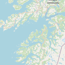
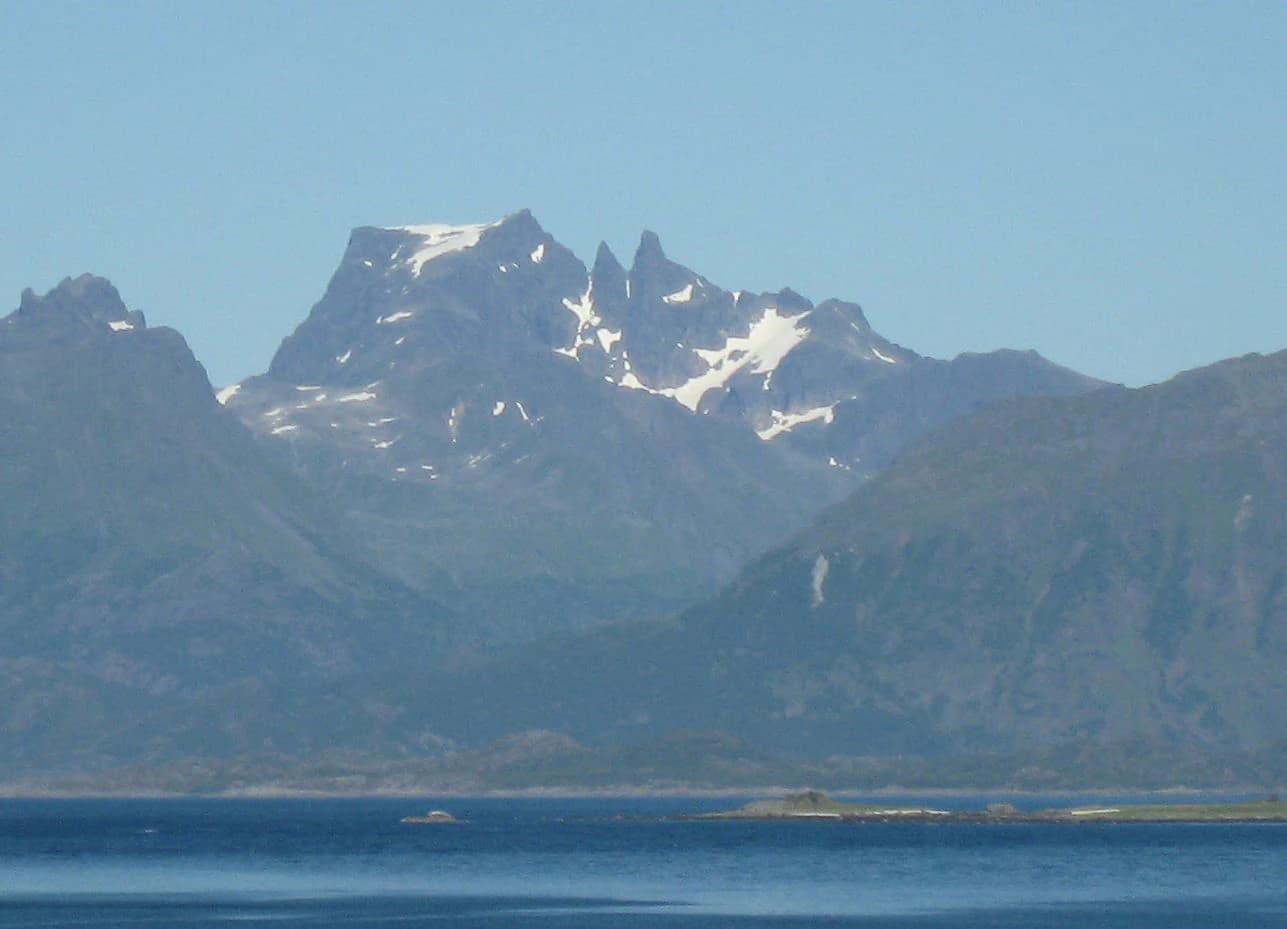
The landscape of Møysalen National Park is defined by its coastal alpine character, where steep mountain peaks rise abruptly from the ocean and deep fjords that indent the island's coastline. The highest point is Møysalen mountain at 1,262 metres, whose jagged silhouette dominates the park's visual identity and provides striking contrast against the surrounding seascape. The terrain descends through alpine zones to reach sea level at theVestpollen fjord branch, creating a near-vertical ecological gradient rarely found in protected areas. Sheltered valleys and lower slopes support birch forest, particularly downy birch, while the terrain is punctuated by numerous fens and bogs that add ecological diversity to the mountain and coastal environments. The combination of exposed peaks, steep cliffs, forested slopes, wetland areas, and protected fjords creates a mosaic of landscapes within the park's relatively compact 51-square-kilometre boundary.

Møysalen National Park ecosystems, habitats, and plant life

The nature of Møysalen National Park encompasses a remarkable diversity of habitats compressed into a coastal mountain setting. The park's altitudinal range from sea level to 1,262 metres supports distinct ecological zones, with alpine communities on exposed heights transitioning through birch woodland to coastal wetland systems at lower elevations. The birch forests represent some of the more intact woodland in this part of Nordland, while the numerous fens and bogs contribute to biodiversity and watershed function. The coastal position exposes the park to maritime influences that shape both vegetation patterns and species distributions, creating a unique blend of inland and coastal ecological characteristics.

Møysalen National Park wildlife and species highlights

Møysalen National Park supports significant populations of birds of prey, with the steep mountain terrain and rich coastal environments providing excellent hunting grounds for several raptor species. White-tailed eagles, golden eagles, gyrfalcons, and peregrine falcons are year-round residents or regular breeders within the park, representing some of Norway's most impressive avian predators. Additional breeding birds of prey include kestrels, merlins, and rough-legged buzzards, creating an especially rich raptor community. The Eurasian otter, classified as vulnerable across Norway, is common within the park's waterways and coastal areas. The Øksfjorden area represents a core habitat for moose on Hinnøya island, supporting a significant population of this large herbivore. Common mammals throughout the park include hares, red foxes, stoats, and American mink, reflecting typical Arctic Norwegian fauna.

Møysalen National Park conservation status and protection priorities

Møysalen National Park was established to preserve an undisturbed coastal alpine landscape that represents a rare ecosystem type within Norway's protected area network. The park's inclusion of sea-level ecosystems, including theVestpollen fjord branch, ensures protection of the complete ecological gradient from mountain to ocean—a feature that distinguishes this park from most other Norwegian national parks, which typically protect higher-elevation terrain. The protection of intact birch forest, wetland systems, and coastal habitats supports biodiversity across multiple ecosystem types. The park's significance for raptor conservation, particularly the presence of multiple breeding pairs of large eagles and falcons, adds important conservation value to Norway's network of protected areas.

Møysalen National Park cultural meaning and human context

Møysalen National Park is situated on Hinnøya, Norway's largest island, which has been inhabited by coastal communities for centuries. The park lies within traditional Sami territory in its broader regional context, though the immediate area around Møysalen reflects Norwegian settlement patterns in the Vesterålen archipelago. Local communities in Lødingen and Sortland municipalities maintain connections to the surrounding landscape, with fishing, small-scale agriculture, and traditional land use having shaped human interaction with this coastal environment over generations. The park's relatively recent establishment in 2003 reflects modern conservation values applied to a landscape that retains strong connections to local cultural identity.

Top sights and standout views in Møysalen National Park

The dramatic coastal alpine scenery of Møysalen, with peaks rising directly from the ocean, represents one of Norway's most visually distinctive protected landscapes. The rare opportunity to walk from alpine terrain down to sea level within a single protected area makes Møysalen unusual among Norwegian national parks. Exceptional bird of prey populations, particularly breeding white-tailed eagles and golden eagles, provide outstanding wildlife observation opportunities for visitors. The protected birch forests and wetland systems add ecological depth to what is already a scenically remarkable Arctic Norwegian landscape.

Best time to visit Møysalen National Park

The optimal time to experience Møysalen National Park runs from late spring through early autumn, when milder temperatures allow access to higher elevations and the extended daylight of Arctic summers provides long hours for exploration. Summer months bring the most accessible trail conditions and the possibility of observing wildlife, particularly birds of prey that are active during the longer days. The winter season transforms the landscape dramatically but brings challenging conditions and limited access, making it suitable only for experienced visitors prepared for Arctic conditions.

Park location guide

Geography guide, regional context, and park location map for Møysalen National Park

Møysalen National Park park geography, regions, and map view in Norway
Understand where Møysalen National Park sits in Norway through a broader geographic reading of the surrounding landscape, nearby location context, and its mapped position within the national park landscape.

How Møysalen National Park fits into Norway

Norway, officially the Kingdom of Norway, is a Nordic country in Northern Europe located on the Scandinavian Peninsula. It encompasses mainland Norway, the Arctic islands of Svalbard and Jan Mayen, and maintains dependencies including Bouvet Island and Antarctic claims. The country has a population of about 5.6 million and is bordered by Sweden, Finland, and Russia. Norway is a unitary parliamentary constitutional monarchy with Oslo as its capital and largest city.

Wider geography shaping Møysalen National Park in Norway

Norway occupies the western and northern portions of the Scandinavian Peninsula in Northern Europe. The country shares a long eastern border with Sweden, and borders Finland and Russia to the northeast. Norway has an extensive coastline facing the Skagerrak, North Sea, Norwegian Sea, and Barents Sea. The terrain is predominantly mountainous with numerous fjords along the coastline.

Map view of Møysalen National Park

Use this park location map to pinpoint Møysalen National Park in Norway, understand its exact geographic position, and read its mapped placement within the surrounding landscape more clearly.

Pigeon | © OpenStreetMap contributors

Location context for Møysalen National Park

Lødingen MunicipalityNordlandSortland Municipality

Explore Møysalen National Park's Coastal Alpine Terrain, Dramatic Fjord Views, and Unique Protected Habitats

Møysalen National Park Photography: Explore Dramatic Coastal Alpine Landscapes and Protected Scenery
Discover comprehensive imagery showcasing Møysalen National Park's dramatic coastal alpine landscapes, where jagged peaks meet deep fjords and extend to sea level, revealing a unique ecological gradient. These protected area views help users visually trace the park's distinct terrain, understand its diverse habitats, and appreciate the striking natural scenery of this Arctic Norwegian wilderness.

Snow-capped Møysalen Mountain rising above a calm body of water with surrounding hills under a clear blue sky

Snow-covered mountain peaks, turquoise lake, and rocky terrain with a winding river in a national park

Park atlas

Trace the coastal alpine terrain and unique conservation landscapes surrounding Møysalen, comparing nearby Norwegian protected areas.

Explore National Parks and Protected Areas Near Møysalen National Park, Norway
Browse other national parks and protected areas across Norway's distinctive coastal alpine geography, extending your discovery from Møysalen National Park into broader regional park contexts. Compare varied conservation landscapes, identify additional Arctic Norway park destinations, and map the spread of protected terrain around the Hinnøya island region.
National parkSenja

Ånderdalen National Park: Ancient Coastal Pine Forest and Glacial Valley Landscape

Norway's protected area within the Senja region.

Delve into the detailed protected landscape of Ånderdalen National Park, a national park located on Norway's Senja island. This entry offers a focused atlas exploration of its unique geographic features, including its celebrated ancient coastal pine forest, dramatic glacial valleys carved from granite, and its significance as a representative example of the northern Norwegian coastal mountain terrain. Understand the mapped boundaries and the natural context of this vital conservation area.

Area
134 km²
Established
1970
IUCN
II
Relief
Mixed relief
Watercolor painting showing a landscape with green hills, distant mountains, and scattered vegetation
National parkNordland

Lofotodden National Park: Iconic Arctic Coastal Protected Landscape in Nordland

Mapped terrain and protected area details for a dramatic Nordic landscape.

Delve into the protected landscape of Lofotodden National Park, a key protected area within Norway's Nordland county. This national park showcases the dramatic convergence of the Lofotenveggen mountain range with the North Atlantic coast, featuring rugged granite peaks and unique coastal terrain. MoriAtlas offers a structured view of its mapped boundaries and geographic context, facilitating detailed discovery of this significant Arctic natural heritage.

Area
99 km²
Established
2018
IUCN
II
National parkNorrbotten County

Vadvetjåkka National Park: Arctic Mountain Landscape and Karst Terrain

Northernmost National Park in Norrbotten County, Sweden

Vadvetjåkka National Park offers a unique atlas perspective on Sweden's northernmost protected mountain landscape. Explore its remote Arctic terrain, characterized by glaciers existing at unusual low altitudes and significant karst cave systems carved into limestone bedrock. This is a vital point for understanding the mapped geography and protected natural features of Norrbotten County and Swedish Lapland.

Area
26.3 km²
Established
1920
IUCN
II
Relief
Mountain
Watercolor illustration showing mountains, a river, and forests in a landscape
National parkNordland

Rago National Park: Northern Norway's Protected Mountain Wilderness and Transboundary Atlas

Explore the mapped terrain and unique landscape context of this significant protected area.

Rago National Park is a protected national park in Nordland, Norway, recognized for its challenging mountainous terrain and its crucial role as part of a vast transboundary protected area complex spanning into Sweden. The park's landscape features alpine lakes and glaciers, offering a stark representation of northern Scandinavian mountain wilderness. Understanding Rago National Park provides insight into regional conservation efforts and the geographic significance of large-scale protected lands in Europe.

Area
171 km²
Established
1971
IUCN
II
Relief
Mountain
National parkNordland

Sjunkhatten National Park: Norway's Protected National Park Identity and Geographic Atlas

Mapped landscape context and regional geography details.

Explore the structured geographic data and protected landscape context for Sjunkhatten National Park, a significant national park in Nordland, Norway. This page provides detailed insights into its mapped boundaries and regional setting, offering an atlas-driven view of its natural terrain. Understand how this protected area contributes to the broader geography of Norway through factual, map-oriented discovery.

Area
417.5 km²
Established
2010
IUCN
II
Relief
Mountain
Watercolor painting showing green hills, a body of water, and distant mountains
National parkNorrbotten County

Abisko National Park

Subarctic national park with unique landscapes

Abisko National Park in Swedish Lapland offers a glimpse into dramatic subarctic terrain. Explore its protected boundaries, river canyons, and alpine tundra through structured geographic data.

Area
77 km²
Established
1909
IUCN
II
Visitors
50K annual
National parkTroms

Rohkunborri National Park: Northern Norway's Dramatic Protected Landscape

Explore its mapped terrain, canyon, and alpine ecosystems.

Rohkunborri National Park offers a profound encounter with northern Norway's wild geography. As a designated national park in Troms county, it features the iconic Sørdalen canyon, a dominant geological feature that shapes its diverse terrain. The park's landscape encompasses a rich ecological gradient, from boreal forests to alpine tundra, supporting a variety of wildlife. This protected area is crucial for understanding Scandinavian mountain ecosystems and transboundary conservation efforts, providing rich content for atlas-based exploration of its mapped boundaries and natural context.

Area
571 km²
Established
2011
IUCN
II
Relief
Mountain
Watercolor illustration of a winding river through a green landscape with distant mountains
National parkNorrbotten County

Padjelanta National Park: Sweden's Largest National Park Protected Plateau Landscape

Explore subarctic terrain, large lakes, and Laponia World Heritage Site geography.

Padjelanta National Park, situated in Norrbotten County, is Sweden's largest national park. It features a distinctive subarctic plateau ecosystem centered around two vast lakes, offering a starkly open landscape compared to adjacent alpine areas. This protected area is renowned for its exceptional botanical and lichen diversity, a vital part of the Laponia World Heritage Site. Users can explore its mapped geography, unique terrain, and the cultural significance of this expansive arctic wilderness.

Area
1,984 km²
Established
1963
IUCN
II
Relief
Highland

Common questions about visiting, size, designation, and location context for Møysalen National Park

Møysalen National Park FAQs for park facts, access, geography, and protected area context
Find quick answers about Møysalen National Park, including protected-area facts, park geography, trail and visitor context, and how the park fits into its surrounding country and regional landscape.
MoriAtlas Explorer

Continue Your Protected Areas Search Across the Global Atlas

Deepen your exploration by continuing the structured search for national parks and protected areas worldwide. Utilize the comprehensive filtering capabilities to compare different conservation landscapes and refine your understanding of global park geography. Discover more about the distribution and characteristics of protected natural areas.

Global natural geography