Mori Atlas logo
National parkLomsdal–Visten National Park

Discover the unique mapped protected landscape of Nordland County, Norway.

Lomsdal–Visten National Park: Norway's Karst Geology and Fjord Landscape Atlas

(Lomsdal–Visten nasjonalpark)

Lomsdal–Visten National Park, a significant national park in Nordland county, Norway, offers a distinct exploration of diverse natural terrain. This protected area is defined by its striking karst geology, featuring extensive cave systems, subterranean rivers, and natural arches that are rare within Norway's protected landscapes. Its dramatic geography includes steep-sided fjords, river valleys, and alpine peaks, creating a richly layered ecosystem from deciduous woodlands to high mountain terrain. The park provides a unique lens through which to understand northern Norwegian regional geography and the mapping of its protected natural areas.

National ParksNorwayNordlandMountain LandscapesFjordsKarst Geology
Stylized illustration showing a river flowing through a mountainous area with pine trees and a waterfall

Lomsdal–Visten National Park

National park

Park overview

Structured park overview, official facts, and landscape profile for Lomsdal, Visten National Park

Lomsdal, Visten National Park park facts, protected area profile, and essential visitor context
Review the core facts for Lomsdal, Visten National Park, including designation, size, terrain, visitor scale, habitats, and operating context in one park-focused overview.

About Lomsdal, Visten National Park

Lomsdal–Visten National Park protects a comprehensive cross-section of Nordland's mountainous interior and fjord landscape. The park extends from the deep fjord arms inland to alpine heights, encompassing a remarkable range of ecosystems within its 1,102 square kilometer boundary. The diversity of landforms results from a complex geological history that produced the karstic features for which the area is particularly notable. Visitors encounter a landscape shaped by glacial processes and subsequent weathering, with rivers carving through the terrain and creating the steep-sided valleys that define much of the park's character. The protected area was established to preserve both the natural environment and the cultural landscape that reflects centuries of human interaction with this northern Norwegian terrain. The park represents one of Norway's more recent national park designations, created in 2009 as part of expanded conservation efforts in the country's north.

Quick facts and research context for Lomsdal, Visten National Park

Lomsdal–Visten National Park is located in Nordland county, Norway, approximately midway between the towns of Brønnøysund and Mosjøen. The park covers 1,102 square kilometers of mountain, valley, and fjord landscape. It was established in 2009 under the Norwegian Directorate for Nature Management. The area encompasses parts of four municipalities and protects a landscape of exceptional geological diversity, including notable karst formations. The park contains evidence of continuous human presence from the Mesolithic era through modern times, reflecting both Sámi and Norwegian cultural traditions.

Park context

Deeper park guide and search-rich context for Lomsdal, Visten National Park

Lomsdal, Visten National Park history, landscape, wildlife, and travel context
Explore Lomsdal, Visten National Park through its history, landscape character, ecosystems, wildlife, conservation priorities, cultural context, and seasonal travel timing in a structured park guide built for atlas discovery and search intent.

Why Lomsdal, Visten National Park stands out

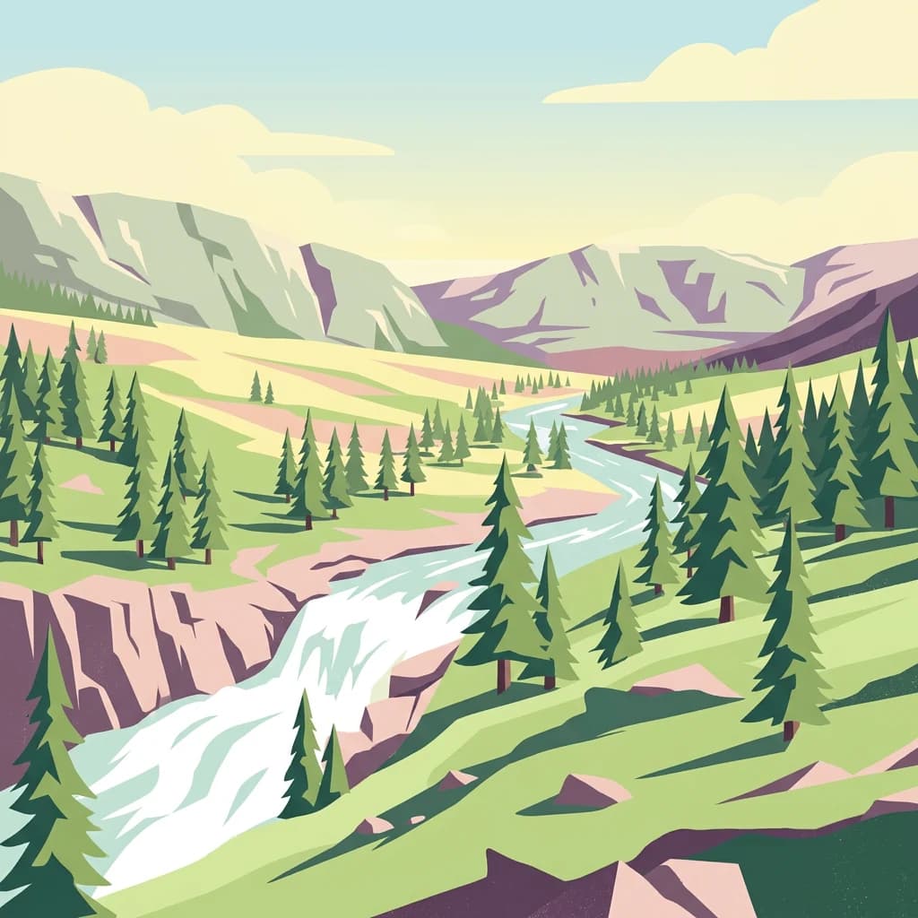
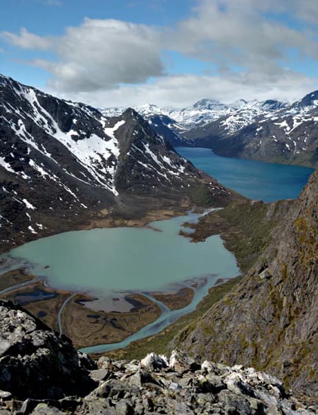
Lomsdal, Visten is best known for its dramatic fjord and mountain landscape with exceptional geological diversity. The karstic terrain featuring caves, subterranean rivers, natural arches, and weathered rock formations represents a standout characteristic uncommon in Norwegian protected areas. The park's combination of steep-sided fjords, deciduous woodlands in the valley floors, coniferous forests on slopes, and alpine terrain above the tree line creates a vertically layered landscape that exemplifies the ecological diversity of northern Norway's mountain regions. The presence of ancient cultural heritage sites spanning thousands of years adds historical depth to the natural landscape.

Snow-capped mountains, turquoise lake, and rocky terrain under a partly cloudy sky
Panoramic view of mountainous landscape with turquoise lake, snow-capped peaks, and rocky foreground under partly cloudy sky

Lomsdal, Visten National Park history and protected-area timeline

The Lomsdal–Visten area contains evidence of human activity spanning from the Mesolithic period, approximately 8,000 to 9,000 years ago, through to the present day. Archaeological findings indicate continuous human presence throughout prehistoric and historic periods. The park area was traditionally associated with Sámi culture, with traces of both historic hunting and gathering practices and the later development of semi-domesticated reindeer husbandry visible throughout the landscape. Following the population losses of the Black Death in the 14th century, ethnic Norwegian settlers expanded into the Sámi areas from the 1500s through the 1800s, re-clearing abandoned farmland along the fjords and major valleys and extending their use of the land into mountain areas. The cultural landscape that resulted from this prolonged period of settlement—including farmsteads, outlying grazing areas, and transportation routes—remains visible within the park today. The Second World War also left marks on the area, and an annual memorial march travels from inner Visten to Eiterådalen to commemorate wartime events in the region.

Lomsdal, Visten National Park landscape and geographic character

The landscape of Lomsdal–Visten National Park presents an exceptional diversity of terrain within a relatively compact protected area. The park encompasses steep-sided fjords that penetrate far inland from the coast, with deciduous woodlands lining the valley floors where conditions permit. The slopes support coniferous forests, primarily consisting of spruce and pine, which give way to mountain birch and alpine vegetation at higher elevations. The park's mountainous terrain rises to true alpine peaks, with bare rock and seasonal snow cover characterizing the highest zones. Rivers traverse the landscape in multiple directions, carving valleys and creating the water features that contribute to the park's character. The geological diversity ranks among the park's most distinctive qualities, with the karstic system representing a particularly unusual element in the Norwegian context. Caves, subterranean rivers, natural arches, and distinctive weathering patterns create a landscape of scientific interest beyond its scenic value.

Lomsdal, Visten National Park ecosystems, habitats, and plant life

The ecological character of Lomsdal–Visten reflects the transitional nature of its location within northern Norway's biogeographic zone. The park encompasses multiple habitat types arranged in response to elevation, slope orientation, and proximity to water. The valley floors and lower slopes support productive deciduous and mixed forests, while coniferous woodlands dominate the mid-elevation zones. Above the tree line, alpine vegetation prevails with species adapted to the harsh conditions of mountain environments. The river systems that traverse the park provide aquatic habitats and movement corridors for wildlife, while the karstic geology influences groundwater patterns and creates unique microhabitats. The diversity of habitats within the park boundary supports a range of species adapted to Norway's northern environments, though the specific biodiversity patterns reflect the relatively continental climate of inland Nordland.

Lomsdal, Visten National Park wildlife and species highlights

The wildlife of Lomsdal–Visten National Park reflects the park's position within the boreal and alpine zones of northern Norway. The forested areas support populations of moose, roe deer, and smaller mammals adapted to woodland environments. Bird species associated with boreal forest habitats are present throughout the park, while the alpine zones provide breeding grounds for species adapted to open mountain terrain. The rivers and waterways support fish populations and provide feeding areas for birds associated with aquatic environments. The exact species composition reflects the park's location at the transition between coastal and continental climate influences, with some species reaching the limits of their ranges in this part of Norway. The relatively recent establishment of the park means that systematic wildlife surveys continue to build understanding of the area's ecological communities.

Lomsdal, Visten National Park conservation status and protection priorities

Lomsdal–Visten National Park was established in 2009 to protect a landscape of exceptional geological diversity and ecological significance in northern Norway. The karstic terrain, with its caves, subterranean rivers, and unique weathering formations, represented a primary motivation for protection, as such features are uncommon in Norwegian protected areas and face vulnerability to disturbance. The protection designation also preserves the cultural landscape that reflects centuries of human interaction with the terrain, including both historic Sámi land use and later Norwegian settlement patterns. The park forms part of Norway's conservation framework under IUCN Category II, reflecting its designation as a national park with the primary purpose of protecting ecological processes and natural features while allowing for compatible human uses such as berry and mushroom gathering.

Lomsdal, Visten National Park cultural meaning and human context

The cultural landscape of Lomsdal–Visten reflects the long and complex history of human settlement in northern Norway. The park area preserves evidence of the region's prehistoric period through Mesolithic archaeological finds that document human presence extending back thousands of years. The Sámi people maintained traditional connections to the landscape, first as hunters and gatherers and later developing reindeer husbandry practices that shaped both the land and the cultural identity of the region. Following the demographic disruptions of the Black Death, ethnic Norwegian settlers expanded into areas previously associated with Sámi use, establishing farms along the fjords and valleys and gradually extending their presence into higher elevations. This layered history of cultural interaction remains visible in the landscape through historic farm sites, transportation routes, and ongoing land use patterns. The park also contains evidence of more recent history, including features associated with the Second World War that remain significant in local commemorative traditions.

Top sights and standout views in Lomsdal, Visten National Park

The karstic landscape of Lomsdal–Visten stands as the park's most distinctive geological feature, with caves, subterranean rivers, natural arches, and weathering formations that are uncommon in Norwegian protected areas. The dramatic fjord and mountain scenery provides representative examples of Nordland's characteristic landscape, with steep-sided fjords rising to alpine peaks within a relatively compact area. The cultural heritage spanning from Mesolithic times through modern reindeer husbandry and wartime history adds historical dimension to the natural landscape. The diversity of ecosystems, from valley deciduous woodlands through coniferous forest to alpine zones, exemplifies the ecological complexity of Norway's mountain environments.

Best time to visit Lomsdal, Visten National Park

The optimal season for visiting Lomsdal–Visten National Park aligns with the brief but productive Norwegian summer months, when daylight hours are long and the mountain terrain is accessible. Summer conditions allow visitors to experience the full range of elevations within the park, from the fjord valleys to alpine areas. The landscape displays its characteristic diversity most fully during the growing season, when vegetation is active and wildlife is more observable. Autumn offers another productive period, particularly for visitors interested in berry and mushroom gathering, which is permitted within the park. Winter conditions in this northern location are severe, with limited daylight and extensive snow cover restricting access to much of the park area. Spring arrives late compared to lower latitudes and brings the gradual transition from winter dormancy to the brief summer growing period.

Park location guide

Geography guide, regional context, and park location map for Lomsdal, Visten National Park

Lomsdal, Visten National Park park geography, regions, and map view in Norway
Understand where Lomsdal, Visten National Park sits in Norway through a broader geographic reading of the surrounding landscape, nearby location context, and its mapped position within the national park landscape.

How Lomsdal, Visten National Park fits into Norway

Norway, officially the Kingdom of Norway, is a Nordic country in Northern Europe located on the Scandinavian Peninsula. It encompasses mainland Norway, the Arctic islands of Svalbard and Jan Mayen, and maintains dependencies including Bouvet Island and Antarctic claims. The country has a population of about 5.6 million and is bordered by Sweden, Finland, and Russia. Norway is a unitary parliamentary constitutional monarchy with Oslo as its capital and largest city.

Wider geography shaping Lomsdal, Visten National Park in Norway

Norway occupies the western and northern portions of the Scandinavian Peninsula in Northern Europe. The country shares a long eastern border with Sweden, and borders Finland and Russia to the northeast. Norway has an extensive coastline facing the Skagerrak, North Sea, Norwegian Sea, and Barents Sea. The terrain is predominantly mountainous with numerous fjords along the coastline.

Map view of Lomsdal, Visten National Park

Use this park location map to pinpoint Lomsdal, Visten National Park in Norway, understand its exact geographic position, and read its mapped placement within the surrounding landscape more clearly.

Pigeon | © OpenStreetMap contributors

Location context for Lomsdal, Visten National Park

Nordland

Visual Atlas of Norway's Diverse Protected Landscapes, Showcasing Karst Geology and Alpine Habitats

Lomsdal–Visten National Park Photos: Explore Dramatic Fjords, Karstic Landscapes, and Alpine Terrain
Visually explore the rugged fjord and mountain scenery of Lomsdal–Visten National Park through a curated gallery of images that highlight its distinctive karstic geology, river valleys, and alpine environments. These detailed park photos provide essential visual context for understanding the unique protected landscapes and ecological diversity found across this significant Norwegian conservation area.

Snow-capped mountains, turquoise lake, and rocky terrain under a partly cloudy sky

A wide view of a river with rapids flowing through a valley surrounded by mountains and forest under a clear blue sky

Park atlas

Explore the Regional Spread of Protected Landscapes and Compare Parks Geographically Across Nordland County

Discover Other National Parks and Protected Areas Near Lomsdal–Visten National Park in Norway
Continue your exploration of Lomsdal–Visten National Park by browsing other protected areas and national parks within Nordland county and its surrounding Norwegian regions. This atlas view allows for geographic comparison, revealing varied mountain terrain, fjord landscapes, and unique karstic geology across connected conservation zones.
National parkNordland

Børgefjell National Park: Explore Norway's Extensive Undeveloped Wilderness and Alpine Terrain

Mapped protected landscape in Nordland, known for granite peaks and arctic fox.

Børgefjell National Park offers a rare glimpse into Norway's most secluded and undeveloped mountain wilderness, spanning dramatic granite peaks and expansive marshlands. This protected landscape in Nordland provides a rich subject for atlas-based discovery, highlighting its unique geological formations, vital habitats for species like the arctic fox and wolverine, and extensive network of lakes and rivers. Navigate its geographic context and understand the protected boundaries of this significant natural area.

Area
1,447 km²
Established
1963
IUCN
II
Relief
Mountain
Watercolor illustration showing mountains, a river, and colorful landscape regions
National park

Saltfjellet, Svartisen National Park: Glacial Terrain & Protected Arctic Wilderness

Norway's vast national park with Svartisen glacier and unique flora.

Saltfjellet, Svartisen National Park spans over 2,100 square kilometers of diverse protected wilderness in Northern Norway. Renowned for Svartisen, Scandinavia's second-largest glacier, its landscape transitions from coastal influences to alpine plateaux. The park's calcareous bedrock supports a rich flora, rare in the region, contributing to its distinct geographic identity. Explore the mapped boundaries and natural terrain of this significant protected landscape.

Area
2,192 km²
Established
1989
IUCN
II
Relief
Mixed relief
National parkTrøndelag

Lierne National Park: A Protected Mountain and Wetland Wilderness in Trøndelag

Explore mapped boundaries, alpine terrain, and Scandinavian wilderness.

Lierne National Park is a prime example of Norway's protected mountain and wetland landscapes, situated in the Trøndelag region. This national park offers a detailed study of terrain shaped by glacial activity, featuring high peaks and expansive peat bogs. Its role in preserving habitats for large carnivores and the Arctic fox adds ecological depth to its geographic profile, providing valuable context for atlas-based discovery of protected areas.

Area
333 km²
Established
2004
IUCN
II
Relief
Mountain
National parkTrøndelag

Blåfjella, Skjækerfjella National Park: Norway's Extensive Protected Wilderness Landscape Atlas

Mapped natural terrain and protected area boundaries in Trøndelag.

Blåfjella, Skjækerfjella National Park stands as a paramount example of Norway's commitment to preserving vast, untouched natural areas. This protected landscape in Trøndelag features expansive mountain plains, glacial valleys, and important wetland habitats, making it a significant area for understanding regional geography and biodiversity. As one of the country's largest national parks, it offers unique insights into the ecological history of spruce migration and serves as a vital sanctuary for large predators. MoriAtlas provides structured map data and geographic context to explore the protected boundaries and diverse terrain of this remarkable wilderness.

Area
1,924 km²
Established
2004
IUCN
II
Relief
Mixed relief
National park

Láhko National Park: Northern Norway's Protected Arctic Landscape and Geographic Atlas Entry

Mapped boundaries and terrain of a key Finnmark national park.

Láhko National Park is a significant protected area within Norway's Finnmark region, representing a vast expanse of sub-Arctic wilderness and characteristic tundra ecosystems. This park serves as a crucial element in the atlas of northern European protected lands, offering insights into the geographic features and ecological integrity of high-latitude environments. Explore Láhko National Park through MoriAtlas to understand its landscape context, mapped terrain, and its role in preserving Nordic wilderness.

National parkNorrbotten County

Pieljekaise National Park: Ancient Birch Woodland and Glacial Terrain in Norrbotten

Explore Sweden's protected landscape and mapped geography.

Pieljekaise National Park, a historic protected area in Norrbotten County, showcases one of Scandinavia's most intact boreal birch woodlands. Its landscape is shaped by ancient glacial activity, featuring a U-shaped valley, rolling hills covered in primeval-like birch forests, and distinctive twin peaks. Positioned along the renowned Kungsleden trail, this national park serves as a vital point for understanding the mapped geography and protected natural heritage of Sweden's Lapland region.

Area
153.4 km²
Established
1909
IUCN
II
Relief
Upland
Watercolor illustration of a landscape with rolling hills, a river, and trees
National parkNordland

Junkerdal National Park: Protected Arctic-Alpine Landscape in Nordland, Norway

Explore mapped boundaries and unique geographic context.

Delve into Junkerdal National Park, a significant protected area within Nordland county, Norway. This national park is celebrated for its rich arctic-alpine flora, including rare plant species that thrive at their southernmost European range. The varied landscape, shaped by glacial activity, features dramatic mountain valleys and alpine plateaus, offering a distinct geographic profile. Understand its protected status and mapped terrain, providing a critical point of discovery for regional landscape context.

Area
682 km²
Established
2004
IUCN
II
Relief
Mountain
National parkNordland

Sjunkhatten National Park: Norway's Protected National Park Identity and Geographic Atlas

Mapped landscape context and regional geography details.

Explore the structured geographic data and protected landscape context for Sjunkhatten National Park, a significant national park in Nordland, Norway. This page provides detailed insights into its mapped boundaries and regional setting, offering an atlas-driven view of its natural terrain. Understand how this protected area contributes to the broader geography of Norway through factual, map-oriented discovery.

Area
417.5 km²
Established
2010
IUCN
II
Relief
Mountain

Common questions about visiting, size, designation, and location context for Lomsdal, Visten National Park

Lomsdal, Visten National Park FAQs for park facts, access, geography, and protected area context
Find quick answers about Lomsdal, Visten National Park, including protected-area facts, park geography, trail and visitor context, and how the park fits into its surrounding country and regional landscape.
MoriAtlas Explorer

Continue Your Protected Areas Search Across the Global Atlas

Deepen your exploration by continuing the structured search for national parks and protected areas worldwide. Utilize the comprehensive filtering capabilities to compare different conservation landscapes and refine your understanding of global park geography. Discover more about the distribution and characteristics of protected natural areas.

Global natural geography