Mori Atlas logo
National parkBlåfjella–Skjækerfjella National Park

Discover Norway's untouched expanse, mapped terrain, and significant protected area boundaries.

Blåfjella–Skjækerfjella National Park: A Premier Wilderness Protected Landscape in Trøndelag, Norway

(Blåfjella-Skjækerfjella nasjonalpark)

Blåfjella–Skjækerfjella National Park represents a cornerstone of Norway's protected natural heritage, covering approximately 1,924 square kilometers of largely untouched wilderness in the Trøndelag region. As one of the largest national parks on the Norwegian mainland, it showcases a diverse geographic tapestry of expansive mountain plains, deeply carved glacial valleys, numerous lakes, and extensive marshlands. This park is a critical zone for understanding both its significant Sami cultural history and its role as one of the last major refuges for large predators in Scandinavia. Through MoriAtlas, users can explore the mapped boundaries, detailed landscape features, and the unique protected-area context of this remote and ecologically vital expanse.

Wilderness ProtectionLarge PredatorsOld-Growth ForestSami Cultural HeritageMountain LandscapeBiodiversity hotspot

Blåfjella–Skjækerfjella National Park

National park

Park overview

Structured park overview, official facts, and landscape profile for Blåfjella, Skjækerfjella National Park

Blåfjella, Skjækerfjella National Park park facts, protected area profile, and essential visitor context
Review the core facts for Blåfjella, Skjækerfjella National Park, including designation, size, terrain, visitor scale, habitats, and operating context in one park-focused overview.

About Blåfjella, Skjækerfjella National Park

Blåfjella–Skjækerfjella National Park represents one of Norway's most significant conservation achievements, protecting a vast expanse of mountainous wilderness in the heart of Trøndelag county. The park's creation in 2004 consolidated what was already Norway's fourth largest national park on the mainland, establishing formal protection for an area that had long served as a de facto wilderness preserve. The landscape is characterized by its remarkable diversity—from open mountain plateaus and rolling terrain to deep forested valleys, shimmering lakes, and extensive marshland systems. Several modest peaks rise from the plateau, with Midtliklumpen standing as the park's high point at 1,333 meters above sea level. The park's boundaries encompass parts of five municipalities, creating a management framework that reflects both the ecological continuity of the landscape and the administrative realities of Norwegian conservation. Prior to its designation as a national park, the area had already received protection through the incorporation of Gressåmoen National Park, which was established in 1970 and covered 182 square kilometers before being absorbed into the larger protected area. The park's continued wild character owes much to its remoteness and the challenging terrain, which has limited development and preserved large tracts of natural habitat.

Quick facts and research context for Blåfjella, Skjækerfjella National Park

Blåfjella–Skjækerfjella occupies a vast tract of central Norwegian wilderness spanning the Trøndelag county, protected since 2004. The terrain combines rolling mountain plateaus with forested valleys, scattered lakes, and wetland marshes. This is historically significant Sami territory with numerous cultural monuments preserved within the park boundaries. The park incorporated the former Gressåmoen National Park (established 1970, 182 km²) upon its creation in 2004. The area is notable as the documented entry point where spruce first migrated into Norway, and it supports a remarkable concentration of large predators including brown bears, lynx, wolverines, and gray wolves—making it unique among Norwegian mainland protected areas.

Park context

Deeper park guide and search-rich context for Blåfjella, Skjækerfjella National Park

Blåfjella, Skjækerfjella National Park history, landscape, wildlife, and travel context
Explore Blåfjella, Skjækerfjella National Park through its history, landscape character, ecosystems, wildlife, conservation priorities, cultural context, and seasonal travel timing in a structured park guide built for atlas discovery and search intent.

Why Blåfjella, Skjækerfjella National Park stands out

Blåfjella, Skjækerfjella is best known as one of Norway's last great wilderness areas, a vast expanse of relatively untouched nature that has retained its ecological integrity despite centuries of human use. The park holds exceptional significance as the site where spruce first arrived in Norway, representing a critical biogeographical landmark in the country's ecological history. It is uniquely distinguished among Norwegian mainland parks for harboring all four of the country's large predators, brown bear, Eurasian lynx, wolverine, and gray wolf, creating one of the most significant predator conservation zones in Scandinavia. The area's Sami cultural heritage, with ancient settlements and sacred sites scattered throughout the landscape, adds a profound human dimension to its wilderness character.

A wide view of a turquoise lake nestled between rocky mountains with snow patches under a partly cloudy sky
Panoramic view of a turquoise lake surrounded by rocky mountains with snow patches under a partly cloudy sky

Blåfjella, Skjækerfjella National Park history and protected-area timeline

Blåfjella–Skjækerfjella National Park was officially established on December 17, 2004, when the Norwegian government designated this vast wilderness area for permanent protection under national park status. The park's creation represented the culmination of ongoing conservation efforts in the region, which had previously seen the establishment of Gressåmoen National Park in 1970. When Blåfjella–Skjækerfjella was formed, Gressåmoen was incorporated into its boundaries, expanding the total protected area to encompass approximately 1,924 square kilometers of mountainous terrain. The establishment of the park followed extensive scientific assessment and consultation with local stakeholders, reflecting Norway's systematic approach to protected area designation. The park's name reflects the Norwegianized forms of the original Sami place names for these mountain areas—Blåfjella deriving from the Sami Låarte (meaning "the blue mountains") and Skjækerfjella deriving from the Sami Skæhkere (referring to the distinctive long mountain ridges that characterize the landscape). This naming acknowledges the deep historical connection between the Sami people and this landscape, which stretches back several centuries of continuous use and habitation.

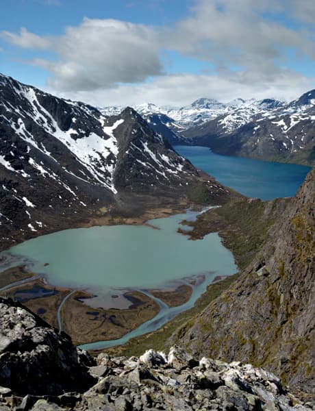
Blåfjella, Skjækerfjella National Park landscape and geographic character

The physical landscape of Blåfjella–Skjækerfjella presents a characteristic north-central Norwegian mountain environment shaped by glacial processes and subsequent weathering. The terrain consists primarily of extensive mountain plains and plateaus, interrupted by forested valleys that descend from the higher ground. Numerous lakes are scattered throughout the park, lying in glacial hollows and valleys, their waters feeding streams that drain through the landscape. Extensive marshland areas occupy valley floors and lower slopes, creating important wetland habitat within the broader mountainous matrix. While the park lacks dramatic high peaks, several summits rise above the surrounding terrain, with Midtliklumpen reaching 1,333 meters as the highest point. The interplay between open exposed mountain terrain and sheltered forested valleys creates a landscape of considerable visual diversity. The geological foundation varies across the park, with areas of softer bedrock supporting more luxuriant vegetation while harder rock formations create more barren terrain—this geological diversity contributes to the ecological variety found within the park's boundaries.

Blåfjella, Skjækerfjella National Park ecosystems, habitats, and plant life

Blåfjella–Skjækerfjella supports an exceptional diversity of nature types within its boundaries, reflecting both its large size and the varied environmental conditions found across the mountain and valley terrain. The park holds particular botanical significance as the documented entry point where spruce first migrated into Norway—a biogeographical landmark of national importance. The flora within the park spans multiple ecological zones, including coastal species that reach their inland limits here, more typical boreal forest species, and alpine plant communities adapted to the higher elevations. Old-growth forests persist in the valley bottoms, representing some of the least disturbed forest remaining in Norway. The variation in bedrock types—ranging from softer formations that support rich plant growth to harder rock with more sparse vegetation—creates a mosaic of habitat conditions that supports this botanical diversity. Adjacent to the main park boundary, four nature reserves provide additional protection for specialized habitats: Arvasslia, Berglimyra and Klumplifjellet, Gaundalsmyra, and Storfloa, each protecting distinctive ecological communities.

Blåfjella, Skjækerfjella National Park wildlife and species highlights

The wildlife community of Blåfjella–Skjækerfjella is notably rich and includes several species of exceptional conservation significance. Twenty-eight mammal species have been documented within the park, a remarkable diversity for a Norwegian protected area. The park is particularly significant for its population of large predators, being the only mainland Norwegian national park where all four of the country's apex predators have been recorded: brown bear, Eurasian lynx, wolverine, and gray wolf. While gray wolf sightings are rare, the presence of these species establishes the park as a critical area for predator conservation in Norway. The Arctic fox, a species of conservation concern in Scandinavia, also occurs here. Three deer species are present: moose, roe deer, and red deer, forming the basis of prey populations that support the predator community. The avifauna is similarly diverse, with numerous bird species observed throughout the park. The lakes support populations of brown trout and Arctic char, providing valuable fishing resources and supporting aquatic food chains.

Blåfjella, Skjækerfjella National Park conservation status and protection priorities

Blåfjella–Skjækerfjella National Park represents one of Norway's most important conservation designations, protecting both ecological processes and cultural landscapes within a single coherent framework. The park's large size and relative wildness make it a critical area for maintaining ecological connectivity across the Scandinavian landscape, allowing natural processes to continue with minimal human interference. The presence of all four large predators distinguishes this park as uniquely important for predator conservation on the Norwegian mainland—these species require large territories and minimal human disturbance, conditions that Blåfjella–Skjækerfjella provides in abundance. The protection of old-growth forests within the park preserves carbon storage and biodiversity values that would be lost to logging or development. The Sami cultural monuments scattered throughout the park represent intangible heritage values that complement the ecological significance, creating a protected area that preserves both natural and cultural dimensions of the landscape. Four adjacent nature reserves—Arvasslia, Berglimyra and Klumplifjellet, Gaundalsmyra, and Storfloa—supplement the national park's protection, creating a network of complementary protected areas.

Blåfjella, Skjækerfjella National Park cultural meaning and human context

The human history of Blåfjella–Skjækerfjella stretches back centuries through the presence and activities of the Sami people, whose cultural heritage remains visible throughout the park landscape. The Sami have lived in and utilized this area for many generations, establishing settlements, creating gathering places, constructing burial sites, and identifying locations of spiritual significance. These cultural monuments provide tangible evidence of the long relationship between the Sami people and this mountainous landscape. The park's name itself derives from Norwegianized forms of the original Sami place names—the mountain area known as Låarte became Blåfjella ("the blue mountains"), while Skæhkere became Skjækerfjella, referring to the distinctive long ridges. This linguistic heritage reflects the deep roots of Sami presence in the region. The contemporary landscape bears the imprint of traditional Sami land use, including patterns of seasonal movement and resource utilization that shaped both the physical environment and the cultural character of the area.

Top sights and standout views in Blåfjella, Skjækerfjella National Park

Blåfjella–Skjækerfjella stands as one of Norway's last great wilderness areas, offering visitors access to extensive tracts of relatively untouched mountain landscape where natural processes continue largely unimpeded. The park's significance as Norway's premier location for observing large predators—including brown bears, lynx, wolverines, and occasionally wolves—makes it uniquely important for wildlife enthusiasts and researchers. The botanical significance of the area, particularly its role as the entry point for spruce into Norway, gives it special importance in understanding the country's ecological history. The network of hiking trails, including some marked routes and mountain cabins for overnight stays, enables exploration of this remote landscape. The rich Sami cultural heritage embedded in the terrain adds historical depth to the wilderness experience, connecting visitors to centuries of human presence in these mountains. Lakes teeming with brown trout and Arctic char provide excellent fishing opportunities in season.

Best time to visit Blåfjella, Skjækerfjella National Park

Blåfjella–Skjækerfjella offers meaningful experiences across multiple seasons, each bringing distinct character to the landscape. Summer and early autumn bring the most accessible conditions for hiking and outdoor activities, with snow-free trails allowing exploration of the mountain plateaus and valley routes. The longer daylight hours of the brief northern summer permit extended expeditions. Autumn offers excellent conditions for wildlife observation as animals become more active before winter, and the landscape displays the characteristic colors of the boreal forest. Winter transforms the park into a true wilderness experience, though conditions become more challenging and some facilities close for the season. The park's northern location means cold temperatures persist well into spring, with the snow season lasting from late autumn through spring. Those seeking solitude and a genuine wilderness experience may find the quieter shoulder seasons particularly rewarding, though all visitors should be prepared for rapidly changing weather and the need for proper equipment in this remote mountain environment.

Park location guide

Geography guide, regional context, and park location map for Blåfjella, Skjækerfjella National Park

Blåfjella, Skjækerfjella National Park park geography, regions, and map view in Norway
Understand where Blåfjella, Skjækerfjella National Park sits in Norway through a broader geographic reading of the surrounding landscape, nearby location context, and its mapped position within the national park landscape.

How Blåfjella, Skjækerfjella National Park fits into Norway

Norway, officially the Kingdom of Norway, is a Nordic country in Northern Europe located on the Scandinavian Peninsula. It encompasses mainland Norway, the Arctic islands of Svalbard and Jan Mayen, and maintains dependencies including Bouvet Island and Antarctic claims. The country has a population of about 5.6 million and is bordered by Sweden, Finland, and Russia. Norway is a unitary parliamentary constitutional monarchy with Oslo as its capital and largest city.

Wider geography shaping Blåfjella, Skjækerfjella National Park in Norway

Norway occupies the western and northern portions of the Scandinavian Peninsula in Northern Europe. The country shares a long eastern border with Sweden, and borders Finland and Russia to the northeast. Norway has an extensive coastline facing the Skagerrak, North Sea, Norwegian Sea, and Barents Sea. The terrain is predominantly mountainous with numerous fjords along the coastline.

Map view of Blåfjella, Skjækerfjella National Park

Use this park location map to pinpoint Blåfjella, Skjækerfjella National Park in Norway, understand its exact geographic position, and read its mapped placement within the surrounding landscape more clearly.

Pigeon | © OpenStreetMap contributors

Location context for Blåfjella, Skjækerfjella National Park

Trøndelag

Discover the diverse terrain and ecological character of this vast Norwegian wilderness through a curated collection of protected area imagery.

Explore Blåfjella–Skjækerfjella National Park Photos: Visualizing Norway's Wilderness Landscapes and Protected Habitats
Explore the diverse landscapes of Blåfjella–Skjækerfjella National Park visually, revealing its expansive mountain plains, forested valleys, and vital wetland habitats. These images offer essential insights into the park's characteristic terrain, ecological identity, and its importance as a premier Norwegian protected wilderness.

A wide view of a turquoise lake nestled between rocky mountains with snow patches under a partly cloudy sky

Park atlas

Discover nearby protected landscapes and compare their unique mountain, forest, and wetland geography across Trøndelag county.

Explore Other National Parks Near Blåfjella–Skjækerfjella, Trøndelag, and Central Norway
After exploring Blåfjella–Skjækerfjella National Park, browse other national parks and protected areas across central Norway, tracing their geographic distribution and unique conservation features. Compare distinct wildernesses, glacial valleys, and Sami cultural sites, gaining a broader understanding of Trøndelag's diverse protected landscapes.
National parkTrøndelag

Lierne National Park: A Protected Mountain and Wetland Wilderness in Trøndelag

Explore mapped boundaries, alpine terrain, and Scandinavian wilderness.

Lierne National Park is a prime example of Norway's protected mountain and wetland landscapes, situated in the Trøndelag region. This national park offers a detailed study of terrain shaped by glacial activity, featuring high peaks and expansive peat bogs. Its role in preserving habitats for large carnivores and the Arctic fox adds ecological depth to its geographic profile, providing valuable context for atlas-based discovery of protected areas.

Area
333 km²
Established
2004
IUCN
II
Relief
Mountain
National parkNordland

Børgefjell National Park: Explore Norway's Extensive Undeveloped Wilderness and Alpine Terrain

Mapped protected landscape in Nordland, known for granite peaks and arctic fox.

Børgefjell National Park offers a rare glimpse into Norway's most secluded and undeveloped mountain wilderness, spanning dramatic granite peaks and expansive marshlands. This protected landscape in Nordland provides a rich subject for atlas-based discovery, highlighting its unique geological formations, vital habitats for species like the arctic fox and wolverine, and extensive network of lakes and rivers. Navigate its geographic context and understand the protected boundaries of this significant natural area.

Area
1,447 km²
Established
1963
IUCN
II
Relief
Mountain
Watercolor illustration of mountains and valleys with green and purple terrain and pink-hued peaks
National parkTrøndelag

Skarvan and Roltdalen National Park: Protected Wilderness and Trøndelag Landscape Atlas

Explore extensive peatlands, alpine terrain, and regional geography.

The Skarvan and Roltdalen National Park detail page offers an atlas-driven exploration of this protected landscape in Norway's Trøndelag region. Discover its vast peatland systems, the intact Roltdalen valley, and its alpine environments. This page provides detailed geographic context and mapped features, highlighting the park's significance within the regional natural heritage.

Area
441.5 km²
Established
2004
IUCN
II
Relief
Mountain
Watercolor painting of mountains, a river, and trees under a pink and yellow sky
National parkNordland

Lomsdal, Visten National Park: Mapped Protected Landscape and Karst Geology in Nordland

Explore the protected geography of northern Norway's unique terrain.

Delve into the protected world of Lomsdal, Visten National Park, a key national park within Norway's Nordland county. This area is celebrated for its extraordinary geological formations, including significant karst features like caves, subterranean rivers, and natural arches, set against a backdrop of dramatic fjords and rugged mountain landscapes. The park’s diverse ecosystems, from valley woodlands to alpine environments, offer rich context for understanding regional geography and the mapped distribution of protected natural areas in Scandinavia. Discover the unique characteristics that define this significant conservation landscape.

Area
1,102 km²
Established
2009
IUCN
II
National park

Sonfjället National Park: Mapped Alpine Terrain and Protected Landscape in Sweden

Explore the glacial geography and subalpine transition zones.

Sonfjället National Park is a key protected area in central Sweden, offering a unique glimpse into an alpine environment shaped by glacial forces. The park's landscape is characterized by the prominent Sånfjället mountain, steep glacial valleys, mires, and small lakes, showcasing raw, natural terrain. As a southern outpost for subalpine ecosystems, it presents a distinct ecological transition zone valuable for geographic discovery and understanding protected nature.

National park

Forollhogna National Park: Norway's Gently Rolling Alpine Protected Landscape Atlas

Explore unique terrain and vital wild reindeer habitat in Central Norway.

MoriAtlas provides structured geographic context for Forollhogna National Park, Norway's nineteenth national park. This area is best known for its distinctively gentle, rolling alpine terrain, a contrast to other Norwegian mountain ranges, and as a critical habitat for wild reindeer. Discover the park's unique landscape character, its role as a protected area, and the ongoing cultural traditions tied to its mountain pastures, all visualized within a comprehensive atlas framework.

Area
1,062 km²
Established
2001
IUCN
II
National parkInnlandet

Femundsmarka National Park: Exploring Norway's Distinctive Wetland and Boreal Protected Landscape

Mapped boundaries and regional geography in Innlandet.

Femundsmarka National Park in Innlandet, Norway, offers a profound look into a preserved wetland wilderness characterized by vast marshlands, numerous lakes, and scattered boreal forests. As a designated national park, its ecological significance is tied to the surrounding water systems and the unique landscape stretching towards the Swedish border. This entry provides detailed geographic context, mapping information, and an understanding of its protected area status, inviting exploration of its remote boreal terrain and notable wildlife habitats.

Area
573 km²
Established
1971
IUCN
II
Relief
Mixed relief
National parkDalarna County

Töfsingdalen National Park: Ancient Old-Growth Forest in Rugged Terrain

Remote protected landscape within Dalarna County, Sweden.

Töfsingdalen National Park showcases a rare example of an ancient, up-to-500-year-old pine forest thriving in extremely rugged, boulder-strewn valley terrain. This protected area, located in Sweden's Dalarna County, offers a glimpse into a near-wilderness landscape shaped by glacial forces and defined by its remoteness and ecological integrity. Discover the mapped park boundaries and the unique geographic context of this remarkably untouched natural reserve.

Area
16.15 km²
Established
1930
IUCN
II
Relief
Lowland

Common questions about visiting, size, designation, and location context for Blåfjella, Skjækerfjella National Park

Blåfjella, Skjækerfjella National Park FAQs for park facts, access, geography, and protected area context
Find quick answers about Blåfjella, Skjækerfjella National Park, including protected-area facts, park geography, trail and visitor context, and how the park fits into its surrounding country and regional landscape.
MoriAtlas Explorer

Continue Your Protected Areas Search Across the Global Atlas

Deepen your exploration by continuing the structured search for national parks and protected areas worldwide. Utilize the comprehensive filtering capabilities to compare different conservation landscapes and refine your understanding of global park geography. Discover more about the distribution and characteristics of protected natural areas.

Global natural geography