Mori Atlas logo
National parkSkarvan and Roltdalen National Park

Discover pristine peatland ecosystems, alpine wilderness, and intact mountain valleys in central Norway.

Skarvan and Roltdalen National Park: Protected Landscape and Trøndelag Regional Geography

(Skarvan og Roltdalen nasjonalpark)

Skarvan and Roltdalen National Park represents a significant protected landscape in Norway's Trøndelag region. Spanning over 441 square kilometers, this national park safeguards extensive pristine peatland ecosystems, which cover more than 40% of its area, and showcases the largest roadless mountain valley in southern Trøndelag. Its protected boundaries encompass diverse terrain, from boreal forests to alpine heath, offering a detailed view of central Norwegian geography and its natural heritage.

National ParkPeatlandsBoreal ForestAlpine EnvironmentMountain WildernessBirdwatching
Illustration showing mountains, waterfall, river, and forest landscape

Skarvan and Roltdalen National Park

National park

Park overview

Structured park overview, official facts, and landscape profile for Skarvan and Roltdalen National Park

Skarvan and Roltdalen National Park park facts, protected area profile, and essential visitor context
Review the core facts for Skarvan and Roltdalen National Park, including designation, size, terrain, visitor scale, habitats, and operating context in one park-focused overview.

About Skarvan and Roltdalen National Park

Skarvan and Roltdalen National Park was established in 2004 to protect a representative sample of Trøndelag's mountain and valley landscapes. The park occupies a strategic position in central Norway, spanning the municipalities of Selbu, Tydal, Meråker, and Stjørdal, not far from the border with Sweden to the east. The protected area encompasses two primary landscape elements: the Skarvan mountainous region, which forms a notable north-south ridge stretching from Ruten to Fongen, and the Roltdalen valley system, the largest roadless mountain valley in southern Trøndelag. The park's 441.5 square kilometers include extensive spruce-dominated forests in the lower elevations, transitioning through mixed pine forest zones into alpine heath communities at higher elevations. The park borders the Stråsjøen-Prestøyan nature reserve, creating a contiguous protected landscape that extends conservation protection across the region. The area holds significance both for its ecological value and as a representation of the cultural landscape history of the Trøndelag region.

Quick facts and research context for Skarvan and Roltdalen National Park

Skarvan and Roltdalen National Park covers 441.5 km² in Trøndelag, Norway, established in 2004. The park protects a significant roadless mountain valley system and serves as a representative example of Trøndelag's natural landscapes. Over 40% of the park area consists of peatlands, including blanket mires and string mires. The elevational gradient spans from mixed spruce-pine forests in the mellomboreal zone up to alpine heath above 1,000 meters. The park borders the Stråsjøen-Prestøyan nature reserve to the north.

Park context

Deeper park guide and search-rich context for Skarvan and Roltdalen National Park

Skarvan and Roltdalen National Park history, landscape, wildlife, and travel context
Explore Skarvan and Roltdalen National Park through its history, landscape character, ecosystems, wildlife, conservation priorities, cultural context, and seasonal travel timing in a structured park guide built for atlas discovery and search intent.

Why Skarvan and Roltdalen National Park stands out

Skarvan and Roltdalen is best known for its extensive pristine peatland ecosystems covering over 40% of the park, and for supporting significant populations of alpine-nesting waterfowl including sea ducks such as common scoter, long-tailed duck, and greater scaup. The Roltdalen valley represents the largest roadless mountain valley in southern Trøndelag, while the Skarvan mountains form a prominent ridgeline characteristic of the region's geology. The park also maintains an extensive network of touring trails maintained by Trondhjems Turistforening, connecting to broader trail systems in the Sylan area.

Wide landscape view showing a large body of water with forested hills in the midground and snow-capped mountains in the background under a clear sky
Panoramic view of snow-capped mountains overlooking a large body of water

Skarvan and Roltdalen National Park history and protected-area timeline

Skarvan and Roltdalen National Park was officially established in 2004 through Norwegian governmental action to protect a significant mountain and valley landscape in Trøndelag county. The creation of the park reflected a broader Norwegian commitment to preserving representative examples of the country's diverse natural landscapes, with particular attention to areas that had retained their ecological integrity despite historical human activity in the region. The park was designated under IUCN Category II as a national park, reflecting its primary conservation objectives while allowing for sustainable outdoor recreation. The governing body responsible for management is the Norwegian Directorate for Nature Management. The park's establishment followed consideration of the area's combination of natural features—including extensive peatlands and forest systems—and its cultural significance as a traditional mountain landscape in Trøndelag.

Skarvan and Roltdalen National Park landscape and geographic character

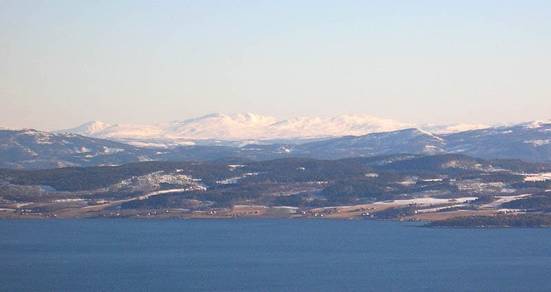
The physical landscape of Skarvan and Roltdalen National Park is characterized by a dramatic elevational gradient that shapes the park's visual and ecological character. The Skarvan mountains form a prominent ridge system stretching from Ruten in the south to Fongen in the north, creating a distinctive backdrop visible from the Trondheimsfjord area. The terrain rises from valley bottoms at lower elevations through forested slopes into alpine zones. The Roltdalen valley is particularly notable as the largest roadless mountain valley in southern Trøndelag, representing an intact valley system that has not been bisected by roads or significant infrastructure. Peatlands dominate the valley floors, with extensive blanket mires and string mires forming a complex wetland matrix that covers over 40% of the park's total area. The landscape transitions from mixed spruce-pine forests in the mellomboreal zone, typically occurring up to approximately 500 meters above sea level, into alpine heath communities above 1,000 meters elevation.

Skarvan and Roltdalen National Park ecosystems, habitats, and plant life

The ecological character of Skarvan and Roltdalen is defined by a complex mosaic of forest types, peatland systems, and alpine habitats that reflect the park's substantial elevational range. The park spans from the mellomboreal zone—Norway's low-boreal vegetation belt—through to alpine heath above 1,000 meters. Spruce forests dominate the lower slopes and valley bottoms, with pine occurring in mixed stands on drier sites. Peatland ecosystems form a defining feature, with blanket mires predominant in the valley bottoms and string mires developing along subtle topographic gradients. On drier slopes, heath communities replace wetland vegetation. The vegetation types within the park vary significantly in their sensitivity to physical disturbance, with bog and lichen heaths proving highly vulnerable to trampling, while grassland communities demonstrate greater resilience. The slow soil formation rates in alpine areas mean that damage to vegetation can require decades to recover, underscoring the importance of careful trail management and visitor infrastructure such as boardwalks on sensitive routes.

Skarvan and Roltdalen National Park wildlife and species highlights

The avian fauna of Skarvan and Roltdalen National Park has been the subject of detailed survey work, revealing a diverse bird community across the park's varied habitats. Avifaunal surveys have recorded 86 species across the park, with particular attention to waterfowl and wetland birds in the extensive peatland systems. The park supports significant breeding populations of sea ducks in its high-altitude tarns and lakes, including common scoter with an estimated 200-300 breeding pairs, long-tailed duck with 40-50 pairs, greater scaup with 15-25 pairs, and velvet scoter with 5-10 pairs. These species favor shallow, fish-free mountain lakes in the eastern alpine belt where invertebrate prey is abundant. Species such as whooper swan, black-throated loon, and Eurasian curlew score highest for sensitivity to human disturbance during the breeding season, reflecting their low tolerance for proximity to human activity at nesting sites. The park's importance as a breeding ground for these species underscores the need for spatial buffers around nesting areas and careful management of trail access.

Skarvan and Roltdalen National Park conservation status and protection priorities

Skarvan and Roltdalen National Park serves as an important conservation area for Trøndelag's mountain and peatland ecosystems, with management strategies focused on balancing visitor access with ecological protection. The extensive peatland systems, covering over 40% of the park, represent a significant conservation resource, and visitor infrastructure has been designed to minimize impacts on these sensitive wetland habitats. Raised boardwalks have been installed on key wetland trails, particularly along the route from Vekta to Prestøyan, to channel foot traffic away from vulnerable mires and lichen heaths. In alpine areas where soil formation is slow, trail alignment follows ridgelines and dry substrates to minimize trampling impacts. Conservation measures also address breeding bird protection, with spatial buffers recommended around sensitive nesting sites—typically 500 meters from raptor nests and 200 meters around waterbird colonies. Seasonal trail management helps ensure that both plant communities and ground-nesting birds can complete their breeding cycles without significant disturbance.

Skarvan and Roltdalen National Park cultural meaning and human context

The Skarvan and Roltdalen area represents a traditional mountain landscape within the Trøndelag region, where human activity has shaped and interacted with the terrain over extended periods. The park's name reflects both the Skarvan mountain range and the Roltdalen valley, linking the protected area to local toponymic traditions. The region has historically supported outdoor recreation and mountain travel, with Trondhjems Turistforening maintaining an extensive network of touring trails that connect Roltdalen to the trail network of the Nord-Trøndelag Tourist Association and extend into the Sylan area. While the park itself was established relatively recently in 2004, the landscape has long served as a destination for hiking, skiing, and other mountain activities that are deeply embedded in Norwegian outdoor culture.

Top sights and standout views in Skarvan and Roltdalen National Park

The park's most distinctive qualities include its extensive pristine peatland systems covering over 40% of the area, the Roltdalen valley as the largest roadless mountain valley in southern Trøndelag, and the significant breeding populations of alpine-nesting sea ducks. The elevational gradient from boreal forest through to alpine heath provides a compact representation of sub-Arctic ecological zones. The Skarvan mountains create a prominent visual landmark visible from the Trondheimsfjord, while the trail network maintained by Trondhjems Turistforening connects the park to broader regional trail systems. The combination of ecological integrity, representative landscape character, and established recreational infrastructure makes the park a significant conservation and outdoor recreation resource in central Norway.

Best time to visit Skarvan and Roltdalen National Park

The character of Skar and Roltdalen changes substantially with the seasons, offering different experiences throughout the year. Summer months bring the most accessible trail conditions, with the alpine areas becoming walkable and the wetland ecosystems in full seasonal display. The breeding bird season peaks in late spring and early summer, making this an optimal time for wildlife observation though visitors should respect buffer zones around sensitive nesting sites. Autumn offers the opportunity to experience the peatland landscapes in their autumn coloration and provides conditions for mushroom foraging in the forest zones. Winter transforms the park into a skiing destination, though the alpine areas require appropriate experience and equipment for winter mountain travel.

Park location guide

Geography guide, regional context, and park location map for Skarvan and Roltdalen National Park

Skarvan and Roltdalen National Park park geography, regions, and map view in Norway
Understand where Skarvan and Roltdalen National Park sits in Norway through a broader geographic reading of the surrounding landscape, nearby location context, and its mapped position within the national park landscape.

How Skarvan and Roltdalen National Park fits into Norway

Norway, officially the Kingdom of Norway, is a Nordic country in Northern Europe located on the Scandinavian Peninsula. It encompasses mainland Norway, the Arctic islands of Svalbard and Jan Mayen, and maintains dependencies including Bouvet Island and Antarctic claims. The country has a population of about 5.6 million and is bordered by Sweden, Finland, and Russia. Norway is a unitary parliamentary constitutional monarchy with Oslo as its capital and largest city.

Wider geography shaping Skarvan and Roltdalen National Park in Norway

Norway occupies the western and northern portions of the Scandinavian Peninsula in Northern Europe. The country shares a long eastern border with Sweden, and borders Finland and Russia to the northeast. Norway has an extensive coastline facing the Skagerrak, North Sea, Norwegian Sea, and Barents Sea. The terrain is predominantly mountainous with numerous fjords along the coastline.

Map view of Skarvan and Roltdalen National Park

Use this park location map to pinpoint Skarvan and Roltdalen National Park in Norway, understand its exact geographic position, and read its mapped placement within the surrounding landscape more clearly.

Pigeon | © OpenStreetMap contributors

Location context for Skarvan and Roltdalen National Park

Trøndelag

A Visual Guide to the Park's Extensive Peatlands, Mountain Wilderness, and Boreal Forest Habitats

Skarvan and Roltdalen National Park Photos: Explore Diverse Protected Landscapes
Gain visual insight into Skarvan and Roltdalen National Park's distinct landscapes, from its expansive peatlands and roadless mountain valleys to the prominent Skarvan range. These images reveal the park's unique blend of boreal forests, alpine heath, and wetland ecosystems, essential for comprehending its protected natural character.

Wide landscape view showing a large body of water with forested hills in the midground and snow-capped mountains in the background under a clear sky

Snow-covered mountain peaks under a pink and blue sky at sunset

Park atlas

Trace regional park geography and compare similar protected landscapes across central Norway's Trøndelag county.

Discover Other National Parks and Protected Areas Near Skarvan and Roltdalen National Park
After exploring Skarvan and Roltdalen National Park, continue your geographic discovery by browsing other national parks and protected areas in the surrounding regions of central Norway. Comparing these diverse landscapes provides valuable insight into regional conservation efforts and the varied protected terrain, from extensive peatlands to mountain wilderness and boreal forests.
National park

Forollhogna National Park: Norway's Gently Rolling Alpine Protected Landscape Atlas

Explore unique terrain and vital wild reindeer habitat in Central Norway.

MoriAtlas provides structured geographic context for Forollhogna National Park, Norway's nineteenth national park. This area is best known for its distinctively gentle, rolling alpine terrain, a contrast to other Norwegian mountain ranges, and as a critical habitat for wild reindeer. Discover the park's unique landscape character, its role as a protected area, and the ongoing cultural traditions tied to its mountain pastures, all visualized within a comprehensive atlas framework.

Area
1,062 km²
Established
2001
IUCN
II
National parkInnlandet

Femundsmarka National Park: Exploring Norway's Distinctive Wetland and Boreal Protected Landscape

Mapped boundaries and regional geography in Innlandet.

Femundsmarka National Park in Innlandet, Norway, offers a profound look into a preserved wetland wilderness characterized by vast marshlands, numerous lakes, and scattered boreal forests. As a designated national park, its ecological significance is tied to the surrounding water systems and the unique landscape stretching towards the Swedish border. This entry provides detailed geographic context, mapping information, and an understanding of its protected area status, inviting exploration of its remote boreal terrain and notable wildlife habitats.

Area
573 km²
Established
1971
IUCN
II
Relief
Mixed relief
National parkDalarna County

Töfsingdalen National Park: Ancient Old-Growth Forest in Rugged Terrain

Remote protected landscape within Dalarna County, Sweden.

Töfsingdalen National Park showcases a rare example of an ancient, up-to-500-year-old pine forest thriving in extremely rugged, boulder-strewn valley terrain. This protected area, located in Sweden's Dalarna County, offers a glimpse into a near-wilderness landscape shaped by glacial forces and defined by its remoteness and ecological integrity. Discover the mapped park boundaries and the unique geographic context of this remarkably untouched natural reserve.

Area
16.15 km²
Established
1930
IUCN
II
Relief
Lowland
National parkTrøndelag

Blåfjella, Skjækerfjella National Park: Norway's Extensive Protected Wilderness Landscape Atlas

Mapped natural terrain and protected area boundaries in Trøndelag.

Blåfjella, Skjækerfjella National Park stands as a paramount example of Norway's commitment to preserving vast, untouched natural areas. This protected landscape in Trøndelag features expansive mountain plains, glacial valleys, and important wetland habitats, making it a significant area for understanding regional geography and biodiversity. As one of the country's largest national parks, it offers unique insights into the ecological history of spruce migration and serves as a vital sanctuary for large predators. MoriAtlas provides structured map data and geographic context to explore the protected boundaries and diverse terrain of this remarkable wilderness.

Area
1,924 km²
Established
2004
IUCN
II
Relief
Mixed relief
National parkInnlandet

Gutulia National Park: Protected Southernmost Mountain Birch Forest Landscape Atlas

Explore Norway's unique subarctic forest geography and park boundaries.

Gutulia National Park stands as a key protected area within Norway's Innlandet region, distinguished by its role in preserving the country's southernmost mountain birch forest ecosystem. Covering approximately 23 square kilometers, this national park provides critical insights into subarctic forest ecology at the southern extent of its natural range. MoriAtlas enables detailed exploration of its mapped terrain and geographic context, offering a valuable resource for understanding this significant protected landscape.

Area
23 km²
Established
1968
IUCN
II
Scope
Terrestrial
Watercolor painting showing a mountainous landscape with a waterfall, grassy fields, and wildflowers
National parkInnlandet

Dovrefjell, Sunndalsfjella National Park: Mapping Norway's Largest Alpine Protected Landscape

Explore its protected boundaries, mountain terrain, and unique ecological significance.

Dovrefjell, Sunndalsfjella National Park is a cornerstone of Norwegian protected areas, offering an expansive alpine wilderness with dramatic mountain scenery. This page details the park's geographic context, mapped landscape features, and its importance as a refuge for unique wildlife like wild reindeer and muskox. Users can investigate the park's protected boundaries and understand its role within the regional geography of Innlandet, contributing to a structured atlas of Scandinavia's natural heritage.

Area
1,693 km²
Established
2002
IUCN
II
Relief
Mountain
National park

Sonfjället National Park: Mapped Alpine Terrain and Protected Landscape in Sweden

Explore the glacial geography and subalpine transition zones.

Sonfjället National Park is a key protected area in central Sweden, offering a unique glimpse into an alpine environment shaped by glacial forces. The park's landscape is characterized by the prominent Sånfjället mountain, steep glacial valleys, mires, and small lakes, showcasing raw, natural terrain. As a southern outpost for subalpine ecosystems, it presents a distinct ecological transition zone valuable for geographic discovery and understanding protected nature.

National parkInnlandet

Dovre National Park: Mapped Alpine Terrain & Protected Reindeer Habitat in Innlandet

Norway's protected mountain plateau landscape and wildlife corridor.

Dovre National Park is a significant protected area in Innlandet, Norway, characterized by its expansive alpine plateau terrain and role as a vital ecological corridor for wild reindeer. This national park offers users an atlas-level view of its mapped natural boundaries, focusing on the unique subarctic mountain landscape and its conservation importance. Understand Dovre National Park's geographic identity and its contribution to a contiguous network of protected lands.

Area
289 km²
Established
2003
IUCN
II
Relief
Mountain

Common questions about visiting, size, designation, and location context for Skarvan and Roltdalen National Park

Skarvan and Roltdalen National Park FAQs for park facts, access, geography, and protected area context
Find quick answers about Skarvan and Roltdalen National Park, including protected-area facts, park geography, trail and visitor context, and how the park fits into its surrounding country and regional landscape.
MoriAtlas Explorer

Continue Your Protected Areas Search Across the Global Atlas

Deepen your exploration by continuing the structured search for national parks and protected areas worldwide. Utilize the comprehensive filtering capabilities to compare different conservation landscapes and refine your understanding of global park geography. Discover more about the distribution and characteristics of protected natural areas.

Global natural geography