
Rivers
Park geography
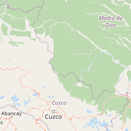
Regional landscape context spanning Cusco and Madre de Dios in Peru
Comprehensive Geographic Profile and Mapped Terrain Boundaries of Manu National Park
The geography of Manu National Park encompasses a vast protected area of 17162.95 square kilometers across the Cusco and Madre de Dios regions. The terrain features a complex elevation range peaking at 4000 meters, defined by a network of rivers, montane forests, and alpine meadows.
Related tags
Amazon rainforestCloud forestUNESCO World Heritage SiteBiosphere reserveBiodiversity hotspot
Peru's Amazon wilderness protecting the world's most biodiverse ecosystems
Manu National Park
Manu National Park is a vast protected area spanning the Madre de Dios and Cusco regions of southeastern Peru, encompassing one of the most ecologically diverse landscapes on Earth. Established in 1973, the park safeguards a remarkable vertical gradient from Andean grasslands at elevations approaching 4,000 meters down to the Amazon basin lowlands, creating a continuum of ecosystems that supports extraordinary biodiversity. The park was recognized as a UNESCO Biosphere Reserve in 1977 and inscribed as a World Heritage Site in 1987, with its protected area expanded in 2009. This enormous reserve covers approximately 1.7 million hectares of pristine wilderness, making it one of the largest national parks in Peru and a critical stronghold for conservation in the Amazon region.
- Location
- Peru
- Park type
- National park
- Established
- 1973
- Area
- 17,162.9 km²
- Highest point
- 4,000 m
Location overview
Regional placement in Cusco and Madre de Dios within Peru
Geographic Location and Regional Setting of Manu National Park
Manu National Park is located in Peru, spanning the Cusco and Madre de Dios regions. As a terrestrial inland reserve, the protected area features no marine, coastal, or transboundary jurisdictions.
- Countries
- Peru
- Regions
- Cusco Region, Madre de Dios Region
- Primary location
- Madre de Dios Region
- Geographic setting
- Inland
Boundary and coordinates
Analyzed spatial geometry and recorded area measurements
Manu National Park Boundary Map and Geographic Extent
Interactive mapped outlines establish clear spatial context for the protected territory. Accompanying measurements detail total area coverage alongside coordinate limits and geographic spans.
- Boundary area
- 16,987.3 km²
- Boundary perimeter
- 815.1 km
- Northernmost point
- 11.3159° S
- Southernmost point
- 13.2059° S
- Easternmost point
- 70.8522° W
- Westernmost point
- 72.4172° W
- Geographic centre
- 12.0851° S, 71.6987° W
- North–south span
- 209.1 km
- East–west span
- 170.3 km
Elevation and terrain
Vertical range data and recorded natural watercourses within the landscape
Manu National Park Elevation Profile and Mapped Terrain Features
Explore the recorded elevation summary reaching up to 4000 meters across mixed mountain terrain. Review structured feature cards detailing named streams, rivers, and lagoons located within the park boundary.
- Maximum elevation
- 4,000 m
- Highest point
- 4,000 m
Selected named natural features
Streams
Río Cumeriali
Lagoons
Cocha Otorongo
Viewpoints
Mirador de Tres Cruces
3,850 m
Rivers
Quebrada Maizal
Streams
Rio Fierro
Environmental setting
Interpreting dominant forest cover, mixed relief, and seasonal water systems
Manu National Park Environmental Classifications and Physical Setting
Recorded landscape features and habitat types serve as interpretive categories for reading the physical setting of Manu National Park. Stored environmental classifications link directly to relevant atlas destinations across mountains, valleys, and river basins.
- Relief
- Mixed relief
- Water
- Major water bodies
- Forest cover
- Dense forest cover
- Seasonality
- Seasonal
Landscape features
Mountains · Valleys · Forest · Grassland · Wetland · Lakes · Rivers
Habitat types
Tropical forest · Montane forest · Alpine meadow · Grassland · Wetland · Lacustrine habitat · Riverine habitat
Park atlas
Discover additional protected landscapes, tracing geographic connections across Peru's Amazon basin and Andean cloud forest regions.
Explore Other National Parks and Protected Areas Near Manu National Park in Peru
Browse a curated list of other national parks and protected areas located geographically close to Manu National Park, encompassing adjacent Amazonian lowlands and high-altitude Andean cloud forest ecosystems. This comparison offers a broader understanding of Peru's diverse conservation landscapes and the regional spread of protected areas surrounding this biodiversity hotspot.
National parkPeru
Park boundaries overlap#1 closest
North

Alto Purús National Park: Peru's Protected National Park Landscape
Mapped boundaries and regional geographic context.
Investigate Alto Purús National Park, a designated national park within Peru. This detailed page provides essential context for understanding the park's geographic location, its protected status, and its role within the broader landscape of western South America. Explore the mapped features and regional setting that define this important conservation area.
- Area
- 25,106.9 km²
- Established
- 2004
- IUCN
- II
- Relief
- Mixed relief
Wildlife reserveMadre de Dios Region
4.9 km away#2 closest
Southeast
Amarakaeri Communal Reserve: Protected Geography and Amazonian Forest Mapping
Wildlife reserve in the Madre de Dios Region of Peru
Covering a large block of Amazonian forest, the Amarakaeri Communal Reserve marks the transition between flat lowland drainage basins and the rising slopes of the Peruvian Yungas. This protected area stands as a hallmark of indigenous-led conservation within the Madre de Dios Region, preserving natural terrain that ranges from dense riverine forests to Andean cloud forest vegetation. The reserve is also anchored by the Harakbut Face, a unique natural landmark formed by centuries of regional erosion.
- Relief
- Mixed relief
- Climate
- Tropical
- Access
- Access unknown
- Scope
- Terrestrial
National parkPeru
102 km away#3 closest
West
Otishi National Park: A Protected National Park Landscape in Peru's Geography
Explore the mapped boundaries and regional landscape of Otishi National Park.
Otishi National Park represents a significant protected area within Peru, offering a unique lens through which to explore regional geography and conservation landscapes. As a designated national park, it highlights the mapped boundaries and the natural terrain that defines this part of South America. Understanding Otishi National Park provides essential context for regional park discovery and the broader atlas of protected lands in Peru.
- Area
- 3,059.73 km²
- Established
- 2003
- IUCN
- II
- Relief
- Mountain
National parkPeru
111 km away#4 closest
Southeast
Bahuaja-Sonene National Park: A Major Amazon Frontier National Park in Peru's Geography
Explore its mapped protected landscape and diverse terrain.
Bahuaja-Sonene National Park is an extensive national park situated on the Amazon frontier in southern Peru, encompassing a crucial transition zone between lowland rainforest and higher-elevation forest ecosystems. Its diverse topography, from river valleys to mountainous slopes, creates varied natural landscapes. The park's protected boundaries are integral to the regional conservation strategy, offering a unique lens through which to study the mapped geography and ecological significance of this vast Amazonian protected area.
- Area
- 10,914.2 km²
- Established
- 1996
- IUCN
- II
- Relief
- Mixed relief
Wildlife reservePando Department
207 km away#5 closest
East

Reserva nacional de vida silvestre amazónica Manuripi: Protected Amazonian Wilderness
Map and geographic context of Pando Department wildlife reserves
Spanning over 700,000 hectares, this wildlife reserve safeguards representative Amazonian ecosystems. Explore the hydrological network of the Madre de Dios and Manuripi river basins, ancient Brazil nut stands, and diverse wetland formations that define this significant regional protected area.
- Area
- 7,470 km²
- Established
- 1973
- Relief
- Lowland
- Climate
- Tropical
Wildlife reservePeru
217 km away#6 closest
Northwest
El Sira Communal Reserve: Geographic Profile and Protected Landscape Context in Peru
Analyzing the Sira Mountain range and regional watershed boundaries
El Sira Communal Reserve sits at the intersection of the Andes and the Amazon, protecting a vast mosaic of habitats across Huánuco, Pasco, and Ucayali. Its geography is defined by deep river valleys, mountain ridges, and a significant altitudinal range that supports diverse wildlife communities. This resource provides a detailed look at the boundaries, terrain, and ecological importance of this major Peruvian protected area.
- Area
- 6,164.13 km²
- Established
- 2001
- IUCN
- VI
- Relief
- Mountain
National parkLa Paz Department
227 km away#7 closest
Southeast
Madidi National Park: National Park Protected Landscape and Geographic Atlas Entry
Explore mapped boundaries and regional context in La Paz Department.
Madidi National Park is a designated national park situated in Bolivia's La Paz Department. This detail entry offers a focused perspective on its protected landscape, its specific geographic setting, and its role within the larger atlas of natural areas. Understand the park's mapped boundaries and its contribution to the regional geography, providing a foundation for structured discovery of Bolivia's protected lands.
- Area
- 18,957.5 km²
- Established
- 1995
- IUCN
- II
- Relief
- Mixed relief

Protected areaPasco Region
259 km away#8 closest
West
San Matías, San Carlos Protection Forest: Geographic Boundaries and Protected Landscape Context
A vital watershed corridor in the Pasco Region of central Peru.
San Matías, San Carlos Protection Forest protects fragile mountain soils and downstream infrastructure from erosion and flooding. Stretching from 300 to 2,250 metres in elevation, the reserve supports a continuous block of highland habitat that serves as a bridge between the Peruvian Yungas and Ucayali moist forest ecoregions, while acting as a cornerstone of the Oxapampa-Asháninka-Yánesha Biosphere Reserve.
- Area
- 1,458 km²
- Established
- 1987
- IUCN
- VI
- Relief
- Mountain
MoriAtlas Explorer
Continue Exploring Manu National Park's Protected Landscape and Geography
Deepen your understanding of Manu National Park by exploring its specific geographic features and protected-area context. This detailed view supports structured atlas discovery, allowing you to trace its boundaries and comprehend its place within the Madre de Dios Region's natural geography. Continue your exploration to build a comprehensive picture of this vital protected landscape.
Browse next
Global natural geography
Explore related park routes
Explore MoriAtlas Global ParksBrowse All MoriAtlas ParksGlobal Park Map DiscoveryMoriAtlas: Browse All CountriesBrowse All MoriAtlas ContinentsNational Park Environment AtlasGrand Canyon National Park AtlasYellowstone National Park AtlasYosemite National Park Atlas and GeographySerengeti National Park AtlasGalápagos National Park Protected LandscapeBanff National Park Geography and AtlasKruger National Park Atlas EntryUluṟu-Kata Tjuṯa National Park AtlasExplore Uluru-Kata Tjuta National Park GeographyPlitvice Lakes National Park AtlasFiordland National Park Protected LandscapeGreat Smoky Mountains National Park AtlasAfghanistan National Parks and Protected AreasAlbania National Parks and Protected AreasAlgeria National Parks and Protected AreasAmerican Samoa National Parks and Protected AreasAndorra National Parks and Protected AreasAngola National Parks and Protected AreasAntarctica National Parks and Protected AreasAntigua and Barbuda Park List