Mori Atlas logo
National parkMatobo National Park

Discover the mapped boundaries and regional geographic context of this national park entity.

Matobo National Park: Protected Landscape and Geographic Atlas in Matobo District, Zimbabwe

Matobo National Park stands as a key protected landscape within Matobo District, Zimbabwe. This page provides an atlas-focused view of the park, detailing its geographic setting and mapped protected area boundaries. Users can explore the unique landscape identity of Matobo National Park and understand its placement within the broader regional geography, offering essential context for any mapped exploration or conservation atlas reference.

Granite LandscapesUNESCO World Heritage SiteRock Art SitesLeopard ConservationBirdwatchingGame Parks

Matobo National Park

National park

Park overview

Structured park overview, official facts, and landscape profile for Matobo National Park

Matobo National Park park facts, protected area profile, and essential visitor context
Review the core facts for Matobo National Park, including designation, size, terrain, visitor scale, habitats, and operating context in one park-focused overview.

About Matobo National Park

Matobo National Park represents a remarkable convergence of geological antiquity, ecological diversity, and human cultural history. The park sits within the Matobo Hills, a landscape composed entirely of granite forming the Matopos Batholith, where erosion has carved fantastic shapes including the famous balancing rocks known as Mother and Child Kopje. Between the granite mountains, narrow swampy valleys known as dambos or vleis form the headwaters of the Maleme, Mpopoma, Mtsheleli and Thuli rivers. The park is divided between the core conservation area and a designated game park of approximately 100 square kilometres in the west, which has been restocked with both white and black rhinoceros. The area holds profound significance for the Shona and Ndebele peoples, who regard the hills as sacred spaces where many rituals and religious activities continue to be performed. The park is managed by the Zimbabwe Parks and Wildlife Management Authority and offers visitors a combination of wildlife viewing, hiking, rock art exploration, and scenic drives through one of Africa's most distinctive protected landscapes.

Quick facts and research context for Matobo National Park

Matobo National Park spans 424 square kilometres in Matobo District, southern Zimbabwe, approximately 35 kilometres south of Bulawayo. The park is the oldest in Zimbabwe, established in 1926 as Rhodes Matopos National Park through a bequest from Cecil Rhodes. It forms part of the southern Africa bushveld ecoregion and was inscribed as a UNESCO World Heritage Site in 2003. The highest point in the hills is Gulati at 1,549 metres. The park incorporates the Lake Matopos Recreational Park and includes a 100 square kilometre game park that has been stocked with white rhinoceros.

Park context

Deeper park guide and search-rich context for Matobo National Park

Matobo National Park history, landscape, wildlife, and travel context
Explore Matobo National Park through its history, landscape character, ecosystems, wildlife, conservation priorities, cultural context, and seasonal travel timing in a structured park guide built for atlas discovery and search intent.

Why Matobo National Park stands out

Matobo National Park is renowned for two exceptional wildlife distinctions: it hosts the world's densest population of leopards, attributable to the abundance of hyrax which constitute approximately 50 percent of their diet, and it contains the highest concentration of black eagles and breeding pairs of these birds anywhere on the planet. The park is equally famous for its extraordinary cultural heritage, with over 3,000 registered rock art sites created by San people beginning around 2,000 years ago, with the main painting periods between 320 and 500 CE. The dramatic granite landscape, with its balancing rocks and cave formations, provides a unique backdrop for both wildlife viewing and archaeological exploration.

Matobo National Park history and protected-area timeline

Matobo National Park was established in 1926 as Rhodes Matopos National Park, making it the oldest national park in Zimbabwe. The park was created through a bequest from Cecil Rhodes, the British imperialist and founder of Rhodesia. The original park borders extended significantly further south and east than the current boundaries. These areas were redesignated for settlement as part of a compromise between colonial authorities and local communities, resulting in the creation of Khumalo and Matobo Communal Lands. The park area subsequently expanded with the acquisition of World's View and Hazelside farms to the north. The current name Matobo reflects the correct vernacular pronunciation of the area. In 2003, the Matobo Hills were designated as a UNESCO World Heritage Site, recognized for exhibiting a profusion of distinctive rock landforms rising above the granite shield that covers much of Zimbabwe. The hills were also the scene of the famous indaba between white settlers and Ndebele leaders during the Second Matabele War in 1896, known in Zimbabwe as the First Chimurenga, which ended with the assassination of the spiritualist oracle the Mlimo. Cecil Rhodes famously walked unarmed into the Ndebele stronghold to persuade the impi to lay down their arms, and he and several other early settlers are buried on the summit of Malindidzimu, also called World's View, a location that remains controversial as it is considered sacred by indigenous groups.

Matobo National Park landscape and geographic character

The Matobo landscape is defined entirely by granite geology, forming the Matopos Batholith. Over two billion years of erosion have produced the area's signature features: smooth, rounded whaleback dwalas rising above broken kopjes strewn with massive boulders. The granite domes and formations create an almost surreal landscape, with the famous Mother and Child Kopje exemplifying the balancing rock formations that dot the hills. Between the granite peaks, narrow valleys have formed, often becoming swampy dambos or vleis due to runoff from the whaleback mountains. These valley wetlands form the headwaters of several rivers including the Maleme, Mpopoma, Mtsheleli and Thuli. The highest point in the hills is Gulati at 1,549 metres, situated just outside the north-eastern corner of the park. The vegetation pattern follows this dramatic topography, with thickets of vegetation filling the valleys and between the rock formations while the granite domes remain relatively exposed.

Matobo National Park ecosystems, habitats, and plant life

The Matobo Hills support remarkable botanic diversity with over 200 tree species recorded within the national park. Key tree species include the mountain acacia, wild pear and paperbark acacia, while the park also contains numerous aloe species, wild herbs and more than 100 grass species. Many rare endemic plants have been recorded in the area. The park is situated within the southern Africa bushveld ecoregion, and the granite-derived soils support distinctive vegetation communities adapted to the rock outcrops and valley systems. Beyond flora, the park contains significant fungal diversity, with both saprophytic and mycorrhizal species playing critical roles in decomposition, nutrient recycling and supporting plant health through symbiotic relationships. These fungi also serve as food sources for insects and small mammals, contributing to the overall ecosystem complexity.

Matobo National Park wildlife and species highlights

Matobo National Park supports exceptional faunal diversity with 175 bird species, 88 mammal species, 39 snake species and 16 fish species recorded within its boundaries. The park is particularly famous for its leopard population, which represents the world's densest concentration. This density is directly linked to the abundance of hyrax, which constitute approximately 50 percent of the leopards' diet. The designated game park in the west of the national park has been restocked with white rhinoceros from KwaZulu-Natal in the 1960s and black rhinoceros from the Zambezi Valley in the 1990s, and has been designated an Intensive Protection Zone for both species. Other notable wildlife includes sable antelope, impala, giraffe, zebra, wildebeest, ostrich, hippos, hyenas and the highest concentration of black eagles worldwide. A limnological research centre at Maleme Dam has studied fish species including the yellow-fish Barbus mattozi since 1950.

Matobo National Park conservation status and protection priorities

Matobo National Park holds significant conservation importance on multiple fronts. The park is designated an Intensive Protection Zone for both white and black rhinoceros, reflecting its critical role in rhino conservation within Zimbabwe. The leopard population density represents a globally significant conservation achievement, maintained by the healthy ecosystem that supports abundant hyrax populations. The designation of the Matobo Hills as a UNESCO World Heritage Site in 2003 recognises the outstanding universal value of the landscape's granite formations and the area's cultural heritage. The park's rock art sites represent irreplaceable cultural assets requiring protection, while the diverse habitats from granite kopjes to valley wetlands support conservation of multiple species. The integration of the Lake Matopos Recreational Park into the national park extends protection to additional areas around Hazelside, Sandy Spruit and Lake Matopos.

Matobo National Park cultural meaning and human context

The Matobo Hills hold profound cultural significance for the indigenous peoples of Zimbabwe. San people lived in these hills approximately 2,000 years ago, leaving a rich heritage of more than 3,000 registered rock art sites throughout the area, with the main painting periods between 320 and 500 CE. The grandeur and spiritual stillness of the hills have contributed to their hallowed reputation, particularly for the Shona and Ndebele peoples, who continue to perform many rituals and religious activities in the area. Before the colonial era, the hills served as the headquarters of the Mlimo, the spiritualist oracle. The area was the scene of the Second Matabele War in 1896, when Ndebele leaders met with white settlers in a famous indaba. Robert Baden-Powell, founder of the Scouting movement, first learned woodcraft fundamentals from American scout Frederick Russell Burnham in these hills. Cecil Rhodes and several other early white settlers are buried at Malindidzimu, also called World's View, a location that remains controversial as indigenous groups consider it sacred. Archaeological finds throughout the caves include clay ovens, stone tools dating to the Pre-Middle Stone Age around 300,000 years ago, and remnants from the 1896 rebellion era.

Top sights and standout views in Matobo National Park

The distinctive granite landscape with its whaleback domes and balancing rocks represents one of southern Africa's most visually striking natural formations. The world's highest concentration of black eagles and breeding pairs provides exceptional birdwatching opportunities. The densest leopard population globally makes the park a premier destination for wildlife viewing, particularly in the western game park. Over 3,000 rock art sites, including major accessible locations at Bambata Cave, Nswatugi Cave and Pomongwe Cave, offer unparalleled archaeological exploration. The 100 square kilometre game park provides the best wildlife viewing with regular sightings of white rhino, sable antelope and other game species. Historical sites include the burial place of Cecil Rhodes at World's View and locations associated with the 1896 indaba. Hiking trails to various peaks and caves, including the challenging hike to Inanke Cave, provide adventurous access to the park's interior.

Best time to visit Matobo National Park

Matobo National Park can be visited throughout the year, though the optimal period runs from April to October during the dry season when wildlife congregates more readily around water sources and vegetation is less dense, making animal spotting easier. The cooler winter months from May to August offer comfortable conditions for hiking and outdoor activities. The wet season from November to April brings greenery and birdlife activity but can make some roads difficult to navigate, particularly to Toghwana Dam during the rainy season when four-wheel drive may be required. The dramatic granite landscapes are visually striking in all seasons, though the clearest views typically occur during the drier months when dust haze is minimal.

Park location guide

Geography guide, regional context, and park location map for Matobo National Park

Matobo National Park park geography, regions, and map view in Zimbabwe
Understand where Matobo National Park sits in Zimbabwe through a broader geographic reading of the surrounding landscape, nearby location context, and its mapped position within the national park landscape.

How Matobo National Park fits into Zimbabwe

Zimbabwe is a landlocked nation in Southeast Africa located between the Zambezi and Limpopo rivers. The country has a population of roughly 17 million people and uses English, Shona, and Ndebele as its primary languages. Once the site of the ancient Kingdom of Zimbabwe and the city of Great Zimbabwe, it gained independence from the United Kingdom in 1980.

Wider geography shaping Matobo National Park in Zimbabwe

Zimbabwe is located in Southeast Africa between the Zambezi River to the north and the Limpopo River to the south. It is landlocked, bordered by South Africa, Botswana, Zambia, and Mozambique. The terrain includes highlands, savanna, and the Zambezi valley.

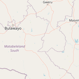
Map view of Matobo National Park

Use this park location map to pinpoint Matobo National Park in Zimbabwe, understand its exact geographic position, and read its mapped placement within the surrounding landscape more clearly.

Pigeon | © OpenStreetMap contributors

Location context for Matobo National Park

Matobo District
Park atlas

Trace the regional geography of national parks and protected areas adjacent to Matobo National Park, comparing their distinct conservation landscapes.

Explore Parks Near Matobo National Park: Discover Other Protected Areas in Zimbabwe
After exploring Matobo National Park's granite kopjes and ancient rock art, broaden your discovery by mapping other protected areas within its regional context. Compare these diverse national parks to understand the varied conservation landscapes, ecological distinctions, and geographic features across the wider southern Zimbabwe region.
Protected areaSouth Africa

Greater Mapungubwe Transfrontier Conservation Area: A Transboundary Protected Landscape in South Africa

Mapped savanna ecosystems and rich cultural heritage at the Limpopo River confluence.

The Greater Mapungubwe Transfrontier Conservation Area, situated in South Africa, stands as a remarkable example of collaborative conservation across national borders. This protected area protects diverse savanna landscapes, particularly around the confluence of the Shashe and Limpopo Rivers, and holds immense cultural value as home to the Mapungubwe Cultural Landscape, a UNESCO World Heritage Site. By examining its mapped geography and protected area status, users gain insight into the ecological corridors vital for wildlife and the ancient archaeological heritage preserved within this significant transfrontier initiative.

Area
4,872 km²
Established
2009
IUCN
VI
Relief
Upland
Watercolor illustration of a savanna landscape with scattered trees and rock formations
National parkLimpopo

Mapungubwe National Park: National Park with Rich Iron Age Archaeology and Savanna Landscapes

Explore Limpopo's unique protected area at the three-nation border.

Mapungubwe National Park is a vital protected area in South Africa's Limpopo region, renowned for its dual significance as a major archaeological site and a diverse natural landscape. This national park protects a significant portion of savanna ecosystems, including unique riparian forests and mopane woodlands, surrounding the historic Mapungubwe Hill. As part of the Greater Mapungubwe Transfrontier Conservation Area, it plays a crucial role in regional conservation, offering a distinct geographic perspective at the confluence of South Africa, Botswana, and Zimbabwe, and serving as a focal point for atlas-based discovery of protected lands.

Area
280 km²
Established
1998
IUCN
II
Relief
Lowland
National parkZimbabwe

Chizarira National Park: Zimbabwe's Remote Protected Landscape on the Zambezi Escarpment

Explore rugged mountains, deep gorges, and unique woodland ecosystems.

Chizarira National Park offers an unparalleled exploration of wilderness and dramatic geography within Zimbabwe. Situated along the imposing Zambezi Escarpment, its landscape is characterized by a 600-meter drop, rugged mountains, and deep river gorges carved by perennial streams. This protected area, known for its remote appeal and rich leopard populations, provides a distinct view of miombo and mopane woodlands, contributing to its unique ecological identity within the regional geography.

Area
2,000 km²
Established
1975
IUCN
II
Relief
Mountain
National parkMasvingo Province

Gonarezhou National Park: National Park Protected Landscape in Masvingo Province

Explore mapped boundaries and regional geography

Gonarezhou National Park represents a significant protected area within the geography of Masvingo Province, Zimbabwe. This page details its specific mapped boundaries and landscape context, offering a focused view for atlas-based exploration. Understand the park's natural terrain and its positioning within the regional protected lands for comprehensive geographic discovery.

Area
5,053 km²
Established
1975
IUCN
II
Relief
Mixed relief
National parkZimbabwe

Kazuma Pan National Park: Zimbabwe National Park Atlas and Protected Landscape Exploration

Unique plains landscape with reliable dry-season wildlife viewing.

Kazuma Pan National Park offers a rare glimpse into Zimbabwe's expansive grassy plains and vital pans, creating a unique protected landscape. This national park is critical for understanding regional wildlife migrations and the geographic context of conservation areas in northwestern Zimbabwe, providing an essential entry point for atlas-based exploration of its terrain and ecological significance.

Area
313 km²
Established
1975
IUCN
II
Relief
Lowland
National parkBotswana

Nxai Pan National Park: Botswana's Iconic Baobab Forests and Salt Pan Landscape

Explore mapped boundaries and unique regional geography.

Nxai Pan National Park offers a compelling glimpse into Botswana's unique semi-arid ecosystems, characterized by the expansive, salt-crusted Nxai Pan itself and the iconic Baines Baobabs dotting its edges. As a protected national park, it represents a significant conservation landscape within the Kalahari Desert region. Understanding its geography involves appreciating the stark visual contrasts, seasonal wetland transformations, and the vast openness of the salt pan environment.

Area
2,578 km²
Established
1992
IUCN
Ib
Relief
Lowland
National parkSouthern Province

Mosi-oa-Tunya National Park: National Park Exploration and Geographic Atlas

Mapped boundaries and protected landscape context in Southern Province, Zambia.

Gain a comprehensive understanding of Mosi-oa-Tunya National Park, a designated national park in Zambia's Southern Province. This entry focuses on its protected area identity, mapped geographic scope, and its position within the regional atlas. Discover the essential landscape context and the structured geographic information that defines this important conservation area, providing a factual foundation for atlas-based exploration.

Area
66 km²
IUCN
II
Climate
Subtropical
Access
Easy access
National parkZimbabwe

Victoria Falls National Park: A Protected Landscape Within Zimbabwe's Geography

Atlas exploration of park boundaries and natural terrain.

Victoria Falls National Park is a key component of Zimbabwe's protected natural areas. This page provides structured information ideal for atlas-based exploration, detailing the park's geographic position and mapped landscape features. Understand its significance as a national park and its contribution to the region's conservation geography.

Area
23.4 km²
IUCN
II
Relief
Mixed relief
Climate
Tropical

Common questions about visiting, size, designation, and location context for Matobo National Park

Matobo National Park FAQs for park facts, access, geography, and protected area context
Find quick answers about Matobo National Park, including protected-area facts, park geography, trail and visitor context, and how the park fits into its surrounding country and regional landscape.
MoriAtlas Explorer

Continue Your Protected Areas Search Across the Global Atlas

Deepen your exploration by continuing the structured search for national parks and protected areas worldwide. Utilize the comprehensive filtering capabilities to compare different conservation landscapes and refine your understanding of global park geography. Discover more about the distribution and characteristics of protected natural areas.

Global natural geography