Mori Atlas logo
Nature reserveMonvert Nature Park

Mapping the ecological recovery and endemic flora of this central highland nature reserve

Monvert Nature Park: A Protected Highland Indigenous Forest in Central Mauritius

Monvert Nature Park serves as a crucial conservation site within the central highlands of Mauritius, protecting a landscape of recovering indigenous woodland and diverse endemic flora. This protected area features a unique combination of native forest remnants, an extensive arboretum, and a specialized fernery located just outside the urban reach of Curepipe. Through its network of forest trails and elevated lookout points, the terrain provides a comprehensive perspective on the island's upland ecological heritage.

indigenous forestrehabilitated forestarboretumbotanical gardenendemic plantscritically endangered flora

Monvert Nature Park

Nature reserve

Park overview

Structured park overview, official facts, and landscape profile for Monvert Nature Park

Monvert Nature Park park facts, protected area profile, and essential visitor context

Review the core facts for Monvert Nature Park, including designation, size, terrain, visitor scale, habitats, and operating context in one park-focused overview.

About Monvert Nature Park

Monvert Nature Park is a conservation-oriented public forest site that combines an interpretive visitor centre, a planted arboretum of native species, a fernery and a network of nature walks through naturalising indigenous woodland. It is located in Forest Side, on the central plateau of Mauritius, between Curepipe and the surrounding highlands, and represents one of the closest examples of native Mauritian forest to any urban area on the island.

The site takes its name from Chevallier Antoine de Monvert, and was originally part of the dense upland forest that once covered much of the Mauritian central plateau. That original canopy included species commonly known as "Bois de Natte", "Bois Manioc" and "Manglier Vert", all of which are emblematic native hardwoods. In the early twentieth century the broader region was harvested for timber, and much of the adjacent land was subsequently converted to commercial plantations of fast-growing Australian eucalyptus, which became one of the dominant invasive tree species in the island's highlands.

A portion of the original forest was left unmanaged and slowly regenerated on its own, producing a recovering stand of indigenous vegetation that became the foundation for the present park. Because this regenerating forest hosts an unusually high concentration of critically endangered plant species, the area was formally set aside for conservation and developed into the nature park between 2001 and 2006 under the oversight of the Mauritian National Forestry Service. The park today functions as both a refuge for rare native flora and a public-facing window onto what Mauritius's indigenous ecosystems once looked like.

The visitor experience is deliberately layered. Near the A10 entrance, an interpretation centre introduces the biodiversity, forests and invasive species challenges of Mauritius, with displays aimed at giving a basic overview of the country's unique flora. Behind the centre, an arboretum of over 150 labelled endemic and indigenous species spreads across grassy slopes crossed by walking paths. At the base of the arboretum, a fernery presents many of the island's critically endangered endemic ferns and orchids, while a raised kiosk serves as a small venue for activities and events.

Further along the road, the larger natural area of the park opens up into a network of looped trails that wind through kilometres of gradually rehabilitating indigenous forest. These trails lead to a high elevated viewing platform at the park's highest point, from which visitors can take in sweeping views across the surrounding highlands and observe the canopy structure of the recovering native woodland. As a whole, Monvert offers a compact but unusually rich introduction to the indigenous botanical heritage of Mauritius.

Quick facts and research context for Monvert Nature Park

Monvert Nature Park lies in Forest Side, roughly three kilometres south-east of Curepipe town centre, with its entrance just off the A10 road. It is situated on state land managed by the Mauritian National Forestry Service and was developed between 2001 and 2006 as a conservation-focused public site.

The park protects a recovering slice of native Mauritian upland forest that was logged in the early 1900s and partially overgrown by invasive eucalyptus plantations after that. Its arboretum holds over 150 labelled endemic and indigenous species, including many that are critically endangered or extinct in the wild, and its fernery displays a significant collection of the island's rare endemic ferns and orchids.

Protection and recognition

Examine the terrestrial protected area designation and management scope for Monvert Nature Park.

Monvert Nature Park Protection Status and Conservation Recognition

Monvert Nature Park features a documented terrestrial protection scope detailing its official conservation designation and management framework. Official recognition records outline the geographic boundaries and governance parameters established for the protected landscape.

Protection details

Protection scope
Terrestrial
Transboundary protection
No
Park context

Deeper park guide and search-rich context for Monvert Nature Park

Monvert Nature Park history, landscape, wildlife, and travel context

Explore Monvert Nature Park through its history, landscape character, ecosystems, wildlife, conservation priorities, cultural context, and seasonal travel timing in a structured park guide built for atlas discovery and search intent.

Why Monvert Nature Park stands out

Monvert Nature Park is best known for being one of the most accessible places in Mauritius to experience the island's indigenous flora outside of the more remote national park interior. Its arboretum showcases over 150 labelled endemic and indigenous species, many of them critically endangered or effectively extinct in the wild, while its fernery highlights rare endemic ferns and orchids. The park is also notable for its story of ecological recovery. The site was originally dense native forest dominated by "Bois de Natte", "Bois Manioc" and "Manglier Vert" before being logged in the early 1900s, after which large parts of the surrounding land were replanted with fast-growing Australian eucalyptus. The portion that survived regeneration as natural indigenous regrowth is what gives Monvert its distinctive character and conservation value today.
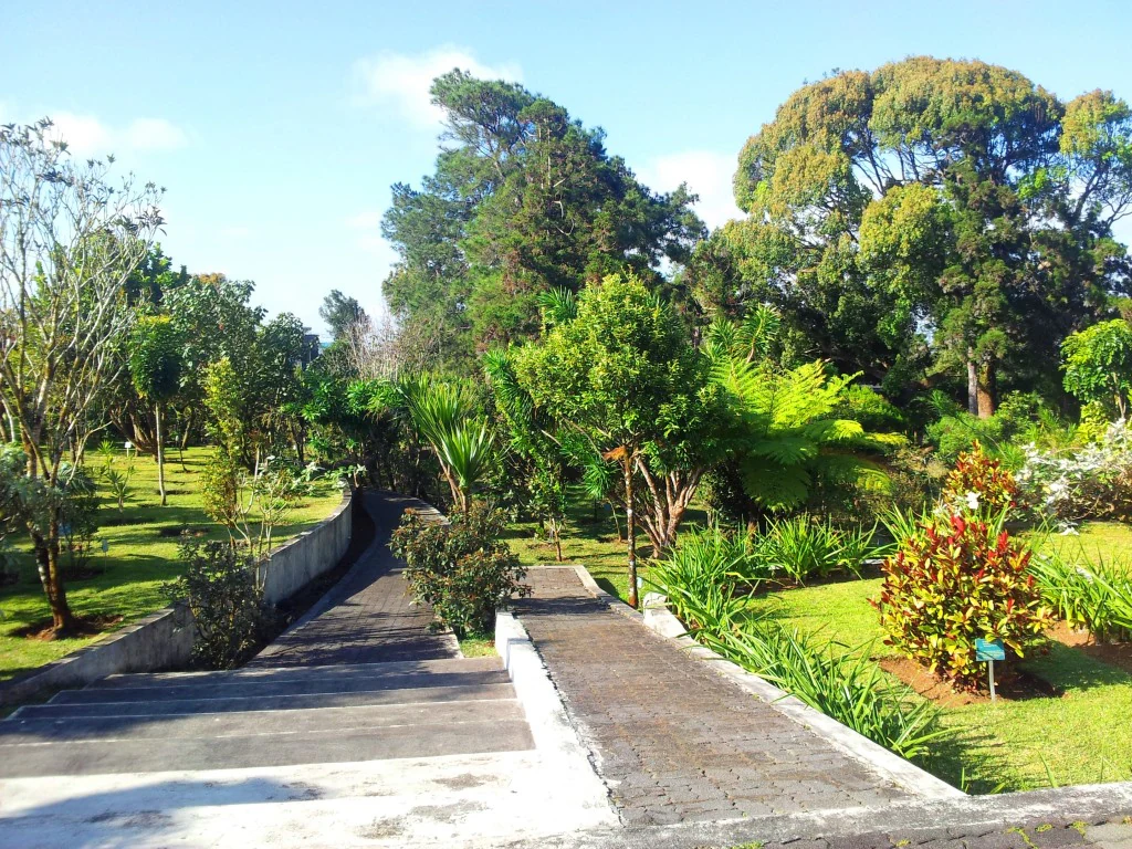
A wide stone staircase and walkway descending into a lush green forest park with a variety of tropical trees, shrubs, and ferns.
A stone pathway leads into the arboretum at Monvert Nature Park, surrounded by lush indigenous greenery.

Monvert Nature Park history and protected-area timeline

The Monvert area is named after Chevallier Antoine de Monvert, a historical figure associated with the forested uplands of the Mauritian central plateau. Before the early 1900s, the site was part of a dense indigenous forest dominated by native hardwoods popularly known as "Bois de Natte", "Bois Manioc" and "Manglier Vert", species that were characteristic of the island's original upland woodlands.

During the early twentieth century, the broader region was opened up to logging. The harvest of native timber cleared large areas of the original canopy, after which much of the surrounding land was replanted with fast-growing eucalyptus brought in from Australia, a species that became one of the most widespread invasive plantation trees in the Mauritian highlands. A portion of the indigenous forest, however, was left undisturbed and allowed to regenerate naturally, gradually re-establishing a patch of native vegetation amid the otherwise alien plantation landscape.

It was this regenerating patch, valued for its unusually high concentration of critically endangered plant species, that led the area to be formally set aside for conservation. Between 2001 and 2006 the site was developed into a public nature park. As state land, it continues to be managed by the Mauritian National Forestry Service, which oversees both its conservation role and its function as a visitor destination dedicated to native Mauritian flora.

Monvert Nature Park landscape and geographic character

Monvert Nature Park sits in the central highlands of Mauritius, in the upland area of Forest Side just outside Curepipe. Topographically, it is a gentle forested plateau landscape rather than a dramatic mountainous terrain, but its position on the central plateau gives it characteristic highland views across the surrounding region. The highest point of the park features an elevated platform from which the canopy of the regenerating forest and the surrounding countryside can be surveyed.

The terrain includes grassy slopes near the visitor centre and arboretum, intersected by a network of walking paths that step down through the different sections of the site. Beyond the developed area, the landscape transitions into kilometres of naturalising indigenous woodland, shaped by looped trails and broken by clearings and small wetland pockets. Small wetlands form part of the visual character of the broader nature walk and contribute to the diversity of habitats within the park.

The site's broader setting is framed by the surrounding highlands of Mauritius, including visible stretches of eucalyptus plantation and the edges of the Curepipe urban area. This contrast, between recovering native forest, commercial eucalyptus stands and nearby built-up zones, is one of the defining visual themes of the landscape at Monvert.
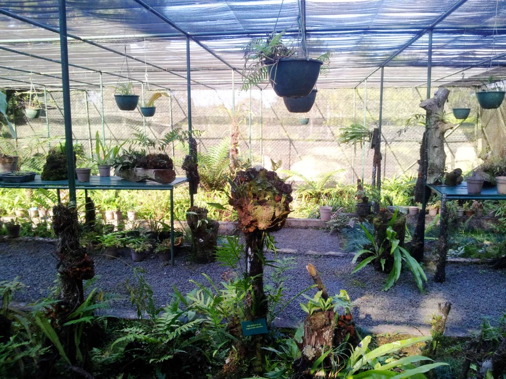
A covered outdoor nursery structure containing multiple ferns and endemic plants in hanging pots and on wooden platforms.
The fernery at Monvert Nature Park, featuring various potted plants and hanging baskets under a shaded canopy.

Monvert Nature Park ecosystems, habitats, and plant life

The ecological identity of Monvert Nature Park is centred on the recovery and preservation of Mauritian indigenous upland forest. The site protects a patch of regenerating native woodland naturally recovering from the logging era, surrounded by a matrix of eucalyptus plantation that illustrates the island's broader history of forest transformation.

Vegetation patterns at the park include native hardwood species historically associated with the central plateau, particularly the trees popularly called "Bois de Natte", "Bois Manioc" and "Manglier Vert". These indigenous trees form the backbone of the recovering canopy, complemented by a much wider range of native and endemic plants cultivated in the arboretum and fernery. The arboretum, laid out across grassy slopes with intersecting paths, displays over 150 labelled endemic and indigenous species, many of them critically endangered or already extinct in the wild.

Wetland features also form part of the park's ecological profile, adding habitat diversity to the predominantly forested environment. Together, the rehabilitating forest, the curated arboretum, the fernery and the wetland pockets create a layered ecological showcase of Mauritius's indigenous flora within a relatively small and accessible area.
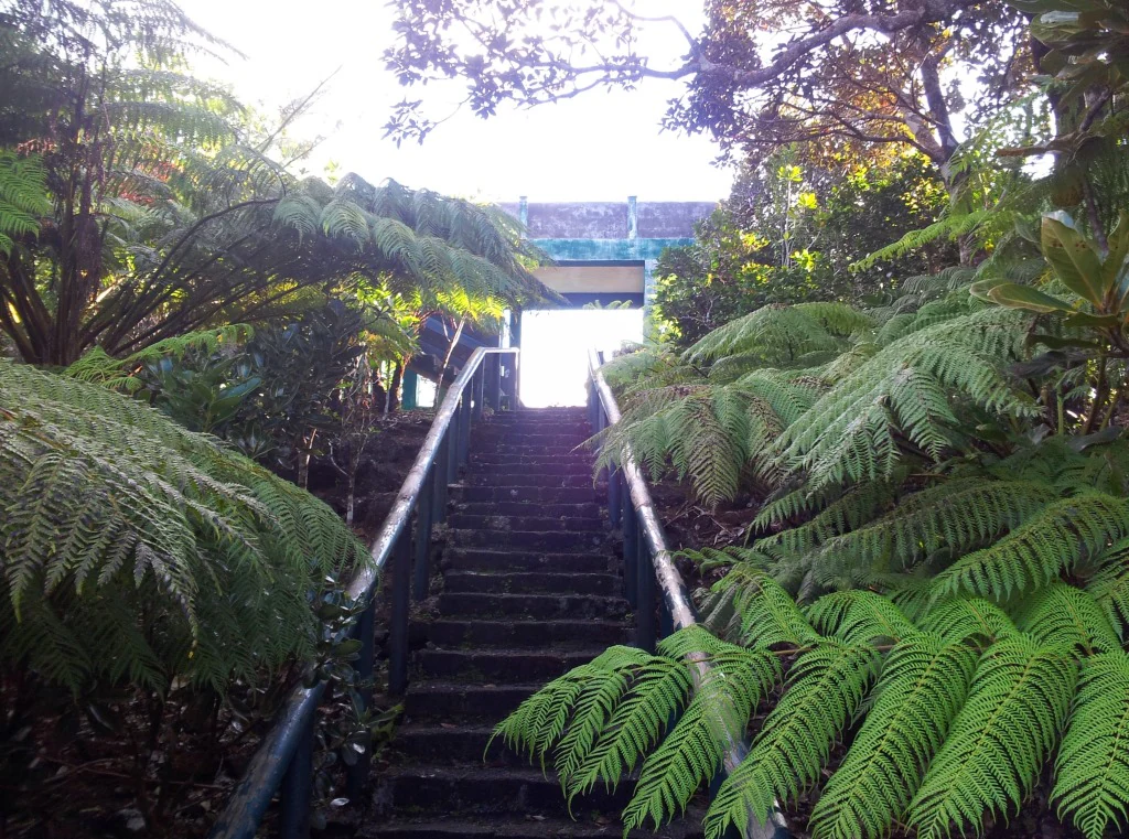
A steep set of wooden stairs enclosed by lush green ferns, leading upwards toward a bright, sunlit lookout structure in a forest setting.
Wooden stairs leading to the lookout tower in Monvert Nature Park.

Monvert Nature Park wildlife and species highlights

The wildlife character of Monvert Nature Park is primarily botanical rather than faunal, but the site's plant communities host an unusually high concentration of critically endangered species for such a small area. Among the most significant elements are the rare native trees "Bois de Natte", "Bois Manioc" and "Manglier Vert", which together form the backbone of the regenerating indigenous canopy.

The arboretum further concentrates rare plant biodiversity by bringing together over 150 labelled endemic and indigenous species, including many that are critically endangered in their natural habitats and others that have already been lost from the wild and now survive largely in cultivation. The fernery adds an additional layer of plant diversity, displaying a curated collection of the island's critically endangered endemic ferns and orchids.

This emphasis on plant conservation makes the park an important site for understanding the broader biodiversity crisis affecting Mauritius, even though the visitor experience is shaped mainly by native flora rather than by charismatic animal species.
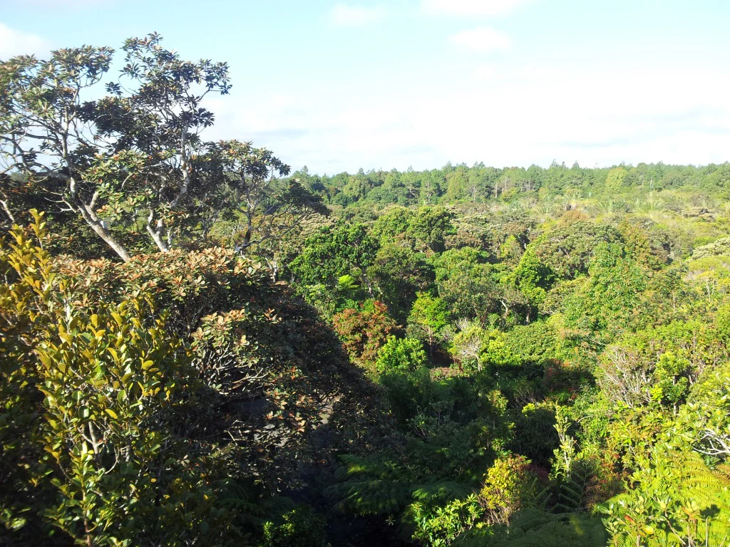
An elevated view looking out over a thick, green forest canopy with varied tree textures under a bright sky.
A view of the dense, indigenous forest canopy within Monvert Nature Park.

Monvert Nature Park conservation status and protection priorities

Monvert Nature Park holds real conservation significance because it safeguards one of the few remaining patches of regenerating indigenous upland forest on the central plateau of Mauritius, in a country where native ecosystems have been heavily reduced by logging, plantations and invasive species. Its establishment between 2001 and 2006 explicitly recognised the unusually high biodiversity value of the surviving native vegetation on the site, including its concentration of critically endangered plant species.

The arboretum is a major conservation asset in its own right. By cultivating over 150 labelled endemic and indigenous species, many of which are critically endangered or extinct in the wild, it functions as a living gene bank that complements in-situ forest protection elsewhere on the island. The fernery's collection of rare endemic ferns and orchids adds an additional ex-situ dimension, helping to preserve species that might otherwise be lost entirely.

As state land managed by the Mauritian National Forestry Service, the park is institutionally anchored within the country's formal forestry and conservation system. Its accessibility, close to Curepipe and reached directly from the A10, also gives it an important role in public education about invasive species, the value of native biodiversity and the importance of protecting what remains of Mauritius's indigenous forest heritage.

Monvert Nature Park cultural meaning and human context

The site carries a quiet layer of local heritage through its name, derived from Chevallier Antoine de Monvert, a historical figure associated with the forested uplands near Curepipe. Its history mirrors broader patterns of land use transformation on the central plateau of Mauritius, where indigenous forest was logged in the early 1900s and large portions of the surrounding land were subsequently converted to fast-growing eucalyptus plantations introduced from Australia.

Today, Monvert also plays a contemporary cultural role as one of the most accessible introductions to native Mauritian flora for residents and visitors staying in the central urban area around Curepipe, making indigenous Mauritian forest a familiar everyday landscape rather than something entirely remote.

Top sights and standout views in Monvert Nature Park

A recovering indigenous upland forest that survived the early twentieth century logging era and now functions as an accessible conservation site just outside Curepipe.

An arboretum of over 150 labelled endemic and indigenous species, including many critically endangered or extinct-in-the-wild plants, and a fernery highlighting rare endemic ferns and orchids.

Looped nature trails and a high lookout platform that together create one of the easiest ways to experience native Mauritian woodland without travelling to the more remote Black River Gorges National Park or offshore islands.

Best time to visit Monvert Nature Park

As a forested site in the central Mauritian highlands near Curepipe, Monvert Nature Park benefits from the cooler, greener conditions typical of the island's plateau. The upland location means temperatures remain more moderate than on the coast, and periods after rainfall tend to bring out the freshness of the regenerating forest, the arboretum plantings and the fernery displays.

Dry, sunny weather generally offers the clearest views from the elevated lookout platform at the park's highest point, while softer, mistier highland conditions emphasise the lush quality of the indigenous canopy. Because the park is primarily a botanical and forest experience, the character of the visit shifts more with general highland weather patterns than with narrow seasonal windows, and the site's accessibility close to Curepipe makes it workable across much of the year.
Monthly climate preview

Long-term representative monthly temperature and precipitation patterns across the protected landscape

Monvert Nature Park Climate Normals, Annual Temperature and Precipitation Rhythm

Representative coordinate records show measured monthly temperature and precipitation variations across the protected landscape from 1991 to 2020. Reviewing the complete twelve-month climate profile provides deeper context for long-term meteorological normals without relying on live forecasts.
Annual mean25 °C
22 °C27 °C
Jan27°
Feb27°
Mar27°
Apr26°
May25°
Jun23°
Jul22°
Aug22°
Sep22°
Oct23°
Nov25°
Dec26°
Warmest month
February

27.1 °C

Coolest month
August

21.9 °C

Wettest month
February

4.2 mm/day

Driest month
July

1 mm/day

Park location guide

Geography guide, regional context, and park location map for Monvert Nature Park

Monvert Nature Park park geography, regions, and map view in Mauritius

Understand where Monvert Nature Park sits in Mauritius through a broader geographic reading of the surrounding landscape, nearby location context, and its mapped position within the national park landscape.

How Monvert Nature Park fits into Mauritius

Mauritius is an island nation in the Indian Ocean and part of the Mascarene Islands. The country gained independence from Britain in 1968 and became a republic in 1992. It is characterized by a diverse population of primarily Indian and Creole descent, with English and French as official languages and Mauritian Creole as the dominant spoken language.

Wider geography shaping Monvert Nature Park in Mauritius

Mauritius is located in the Indian Ocean approximately 2,000 km east of Africa and east of Madagascar. The main island is volcanic in origin, and the country also includes the islands of Rodrigues, Agaléga, and St. Brandon (Cargados Carajos shoals). The territory is part of the Mascarene Islands, with nearby Réunion being a French overseas department.

Map view of Monvert Nature Park

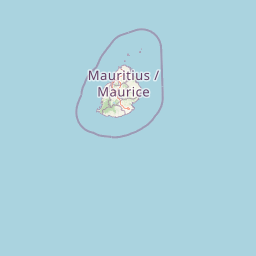
Use this park location map to pinpoint Monvert Nature Park in Mauritius, understand its exact geographic position, and read its mapped placement within the surrounding landscape more clearly.

Pigeon | © OpenStreetMap contributors

Visualizing upland forest terrain, rare endemic flora, and highland protected habitats.

Monvert Nature Park Photos and Landscape Scenery Exploration

Photographic records reveal the distinct highland terrain, recovering native woodland, and specialized botanical habitats found throughout Monvert Nature Park. Visual exploration of the protected landscape provides clear insight into the upland forest environment and rare endemic plant communities.

A wide stone staircase and walkway descending into a lush green forest park with a variety of tropical trees, shrubs, and ferns.

A weathered wooden boardwalk path extends from the foreground into a lush, green wetland and forest area under bright, hazy sunlight.

A covered outdoor nursery structure containing multiple ferns and endemic plants in hanging pots and on wooden platforms.

A steep set of wooden stairs enclosed by lush green ferns, leading upwards toward a bright, sunlit lookout structure in a forest setting.

An elevated view looking out over a thick, green forest canopy with varied tree textures under a bright sky.

Park atlas

Compare regional upland forests and protected natural areas across Mauritius

Explore Parks Near Monvert Nature Park and Surrounding Protected Landscapes

Browse other protected areas and regional conservation zones situated throughout the central highlands of Mauritius. Extending your research beyond Monvert Nature Park provides deeper geographic comparison across related upland habitats and native botanical reserves.
Watercolor painting showing mountains in the distance, a body of water, and green vegetation in the foreground
National parkMauritius
About 5.5 km away#1 closest

Southwest

Black River Gorges National Park: Key Protected Landscape and National Park in Mauritius

Explore mapped boundaries and endemic wildlife conservation in the southwest highlands.

Black River Gorges National Park is the largest protected area on Mauritius, critically preserving native rainforest and unique endemic species. This national park encompasses approximately 67.54 square kilometers, showcasing varied ecosystems from humid upland forests to marshy heathlands within its rugged highland terrain. The park's geography, characterized by deep gorges and steep slopes, provides essential habitats and plays a crucial role in the island's conservation efforts, making it a significant site for understanding Mauritius's natural heritage.

Area
67.54 km²
Established
1994
Relief
Upland
Climate
Tropical
A minimalist watercolor painting showing green rolling hills and distant terrain on a white background.
Nature reserveMoka District
About 16 km away#2 closest

North

Le Pouce Nature Reserve: Volcanic Geography and Protected Upland Habitat in Mauritius

A rugged basalt peak in the Moka District mountain range.

Le Pouce Nature Reserve guards a critical 0.69 square kilometer patch of upland forest on the slopes of the third highest mountain in Mauritius. This protected area is recognized for its dramatic volcanic terrain and as the rare surviving home for the critically endangered Le Pouce Mountain Screwpine, providing an essential window into the island's unique ecological and geological history within the Moka Range.

Area
0.69 km²
Established
1951
Relief
Mountain
Climate
Tropical
A soft watercolor painting of a rolling landscape with green trees and hills in the background on a white background.
Nature reserveChamarel
About 19 km away#3 closest

Southwest

Ebony Forest Nature Reserve: A Detailed Atlas of Chamarel's Restored Protected Landscapes

Indigenous forest restoration in southwest Mauritius

Ebony Forest stands as a primary nature reserve in the Chamarel hills of Mauritius, where extensive restoration efforts have reclaimed native semi-dry forest and upland ecosystems. This site offers an essential look at the island's endemic biodiversity through its protected ebony stands and rehabilitated slopes, making it a key component of the broader southwestern Mauritian conservation network.

Established
2017
Relief
Upland
Climate
Tropical
Access
Easy access
Nature reserveGrand Port District
About 19 km away#4 closest

East

Vallée de Ferney Nature Reserve: Protected Mountain Landscapes in the Grand Port District

Indigenous rainforest, volcanic terrain, and conservation refuge

Located in the Bambou mountains of southeastern Mauritius, Vallée de Ferney is a 200-hectare nature reserve known for its protected indigenous rainforest and ongoing rewilding projects. As a key conservation site in the Grand Port District, the reserve offers a look at rare endemic species and the unique moisture-loving vegetation of the island's eastern volcanic series. Explore the mapped boundaries and natural terrain of this significant protected landscape.

Area
2 km²
Established
2006
Relief
Mountain
Climate
Tropical
Nature reserveMauritius
About 24 km away#5 closest

East

Ile aux Aigrettes: Exploring the Protected Coral Coastal Landscape of Mauritius

A critical nature reserve and rewilding site in the Grand Port bay

Ile aux Aigrettes represents a unique geographic outpost off the south-east coast of Mauritius, defined by its flat coral limestone terrain. As a protected nature reserve, it offers insights into the recovery of rare dry coastal forest ecosystems and the ongoing scientific efforts to maintain endemic biodiversity on a small maritime scale.

Area
0.27 km²
Established
1965
Relief
Lowland
Access
Easy access
A horizontal watercolor painting showing green coastal vegetation, a small waterway, and distant hills under a soft sky.
National parkMauritius
About 27 km away#6 closest

East

Île aux Fouquets National Park: Coral Islet Geography and Lighthouse Heritage in Mauritius

Protected maritime landscape and offshore reef terrain

This compact coral island represents a critical piece of the national park system in Mauritius. Known for its distinct limestone geology and nineteenth-century lighthouse ruins, it provides a unique window into the maritime history and offshore reef ecosystems of the Indian Ocean, contrasting with the volcanic landforms of the mainland.

Area
0.025 km²
Established
2004
Relief
Lowland
Access
Remote access
Watercolor illustration of a forest scene with trees, ferns, and distant mountains
National parkMauritius
About 30 km away#7 closest

Northeast

Bras d'Eau National Park: Mauritius National Park Protected Landscape Discovery

Explore coastal terrain, endemic species habitats, and wetland geography.

Bras d'Eau National Park, situated on Mauritius, offers an in-depth look at a protected coastal lowland landscape vital for conservation. This national park showcases remnant forest patches critical for endemic flora and fauna, complemented by a unique system of four mares, including the mangrove-rich Mare sarcelle. Its mapped geography provides context for island ecosystems and serves as a key location for understanding Mauritius's protected natural areas.

Area
4.97 km²
Established
2011
Relief
Lowland
Climate
Tropical
A minimalist, flat vector illustration showing a colorful island scene with a waterfall, forest, and surrounding water.
Protected areaRivière du Rempart District
About 53 km away#8 closest

North

Île Plate: Protected Area Geography and Natural Features in Rivière du Rempart District

Island biodiversity and volcanic landscapes in northern Mauritius

Île Plate is a compact island covering approximately 2.5 square kilometres, notable for its basalt geology and status as a protected area. It anchors a wider system of islets, offering a rich study of indigenous vegetation, seabird habitats, and tangible maritime history in the Indian Ocean.

Area
2.53 km²
Relief
Lowland
Access
Moderate access
Scope
Mixed

Common questions about visiting, size, designation, and location context for Monvert Nature Park

Monvert Nature Park FAQs for park facts, access, geography, and protected area context

Find quick answers about Monvert Nature Park, including protected-area facts, park geography, trail and visitor context, and how the park fits into its surrounding country and regional landscape.
MoriAtlas Explorer

Continue Your Protected Areas Search Across the Global Atlas

Deepen your exploration by continuing the structured search for national parks and protected areas worldwide. Utilize the comprehensive filtering capabilities to compare different conservation landscapes and refine your understanding of global park geography. Discover more about the distribution and characteristics of protected natural areas.

Global natural geography