
Mori Atlas logo
National parkBras d'Eau National Park

Discover the mapped geography of coastal lowlands, remnant forests, and vital wetlands.

Bras d'Eau National Park: Protected Landscape and Map Context in Mauritius

Bras d'Eau National Park represents a crucial protected area on Mauritius, safeguarding a distinct coastal lowland landscape. This national park preserves critical fragments of original Mauritian forest, offering vital habitat for endemic species within a terrain shaped by a winding inland waterway and four shallow freshwater bodies known as mares. Explore its unique geography, from mangrove-fringed wetlands to areas supporting endangered flora and fauna, providing essential context for Mauritius's natural heritage.

national parkcoastal wetlandsendemic speciesisland conservationforest reservesbirdwatching
Stylized illustration of a waterfall flowing into a river surrounded by forested mountains

Bras d'Eau National Park

National park

Park overview

Structured park overview, official facts, and landscape profile for Bras d'Eau National Park

Bras d'Eau National Park park facts, protected area profile, and essential visitor context

Review the core facts for Bras d'Eau National Park, including designation, size, terrain, visitor scale, habitats, and operating context in one park-focused overview.

About Bras d'Eau National Park

Bras d'Eau National Park occupies a coastal strip in the northeast of Mauritius, near the small settlement of Poste Lafayette. The park encompasses approximately 497 hectares of state land and surrounding reserves, lying between the coast and inland areas that were historically covered by indigenous Mauritian forest. Unlike the more famous Black River Gorges National Park in the island's southwest, Bras d'Eau remains relatively quiet and rarely visited, offering a more solitary nature experience. The original forests of this area were largely cleared during the colonial period and replaced with commercial timber plantations of species introduced from the Caribbean, Australia, and elsewhere. However, pockets of the original biodiversity survived among these plantations, and the presence of these remnant endemics prompted the establishment of the national park. Today the park provides protection for some of the last surviving populations of critically endangered Mauritian plant species while offering visitors walking trails through a landscape that blends plantation forest with native vegetation remnants and coastal wetlands.

Quick facts and research context for Bras d'Eau National Park

Bras d'Eau National Park covers approximately 5 square kilometres in the northeast of Mauritius, established in October 2011 under the Wildlife and National Parks Act of 1993. The park features four coastal lakes known as mares, with the largest being Mare sarcelle, which contains mangrove communities and serves as a habitat for migratory bird species. Two marked walking trails traverse the park, including a 6.6 kilometre trail connecting the visitor centre to Mare sarcelle. The area contains historic 200-year-old ruins including the remains of a sugar mill and lime kiln, reflecting the island's colonial agricultural history.

Protection and recognition

Exploring terrestrial conservation boundaries and official designation frameworks for the park

Bras d'Eau National Park Protection Status and Protected Area Designation

Map-based explorers can browse the documented terrestrial scope and official protection boundaries established for Bras d'Eau National Park. Tracking certified global conservation records supports clear comparisons of regional ecological frameworks and localized land management systems.

Protection details

Protection scope
Terrestrial
Transboundary protection
No
Park context

Deeper park guide and search-rich context for Bras d'Eau National Park

Bras d'Eau National Park history, landscape, wildlife, and travel context

Explore Bras d'Eau National Park through its history, landscape character, ecosystems, wildlife, conservation priorities, cultural context, and seasonal travel timing in a structured park guide built for atlas discovery and search intent.

Why Bras d'Eau National Park stands out

Bras d'Eau is best known for its role in protecting rare endemic Mauritian flora and fauna that survive in remnant forest patches amid commercial timber plantations. The park preserves critically endangered plants including two species of giant Mauritian ebony trees and rare ferns, alongside endemic bird species such as the Mascarene paradise flycatcher, Mauritius cuckooshrike, and Mauritius grey white-eye. Its wetland system centred on Mare sarcelle supports mangrove ecosystems and serves as a stopping point for migratory birds including whimbrels, striated herons, and common moorhens.
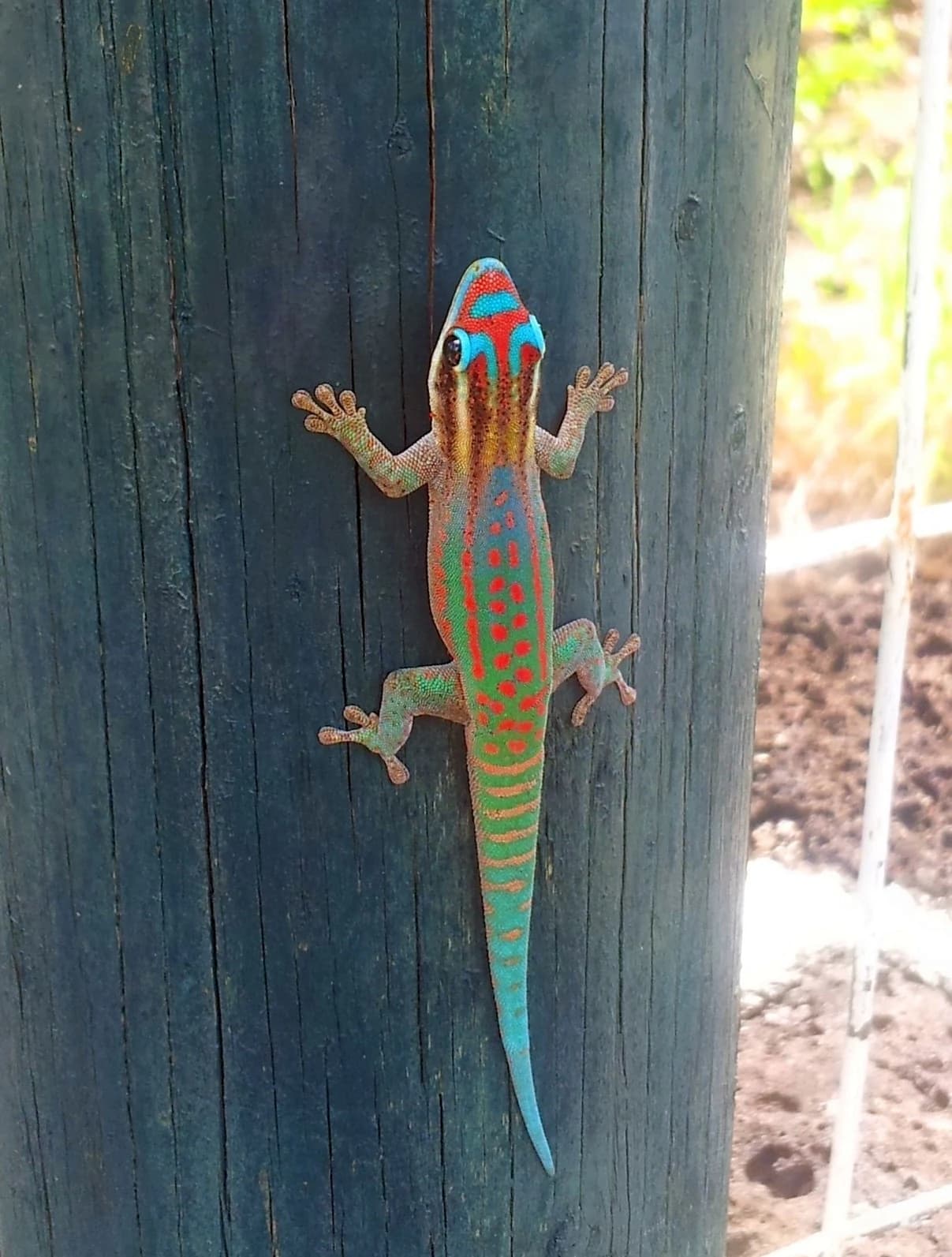
A colorful Ornate Day Gecko with blue, red, and green markings clinging to a dark wooden post
Ornate Day Gecko (Phelsuma ornata) clinging to a wooden post in Bras d'Eau National Park

Bras d'Eau National Park history and protected-area timeline

The name Bras d'Eau derives from the distinctive waterway that winds through the area, its shape resembling an arm reaching inland from the sea. The region experienced extensive deforestation during the early colonial period as original indigenous forests were cleared for timber extraction and agricultural expansion. The remnants of native forest that survived among the commercial plantations acquired renewed significance as conservation priorities grew in the late twentieth and early twenty-first centuries. The presence of critically endangered endemic species in these forest fragments provided the ecological justification for establishing protected status. Bras d'Eau was officially declared a national park on 25 October 2011, becoming the second land-based national park in Mauritius after Black River Gorges. The designation was made under Section 11(1) of the 1993 Wildlife and National Parks Act, with management responsibilities falling to the Mauritian National Parks and Conservation Service.

Bras d'Eau National Park landscape and geographic character

The physical landscape of Bras d'Eau National Park consists of coastal lowland terrain with gentle elevation changes transitioning from the shoreline to inland areas. The defining geographical feature is the bras d'eau itself, a winding body of water that extends from the coast inland, giving the area its name. Four shallow freshwater bodies known locally as mares punctuate the park, each with distinct characteristics. Mare chevrettes takes its name from the small shrimp that inhabit its waters, while Mare mahogany is surrounded by the commercial mahogany plantations that dominate much of the park. Mare Coq des bois refers to the paradise flycatcher that frequents the area, and Mare sarcelle, the largest of the four, is named after an extinct local waterfowl species. The landscape around the mares ranges from dense plantation forest to open wetland areas with mangrove growth, particularly around Mare sarcelle.
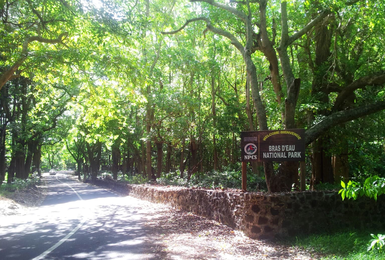
Paved road leading into Bras d'Eau National Park, featuring a stone wall and entrance sign surrounded by dense green trees
Entrance sign for Bras d'Eau National Park with stone wall and tree-lined road

Bras d'Eau National Park ecosystems, habitats, and plant life

The ecological character of Bras d'Eau reflects the dramatic transformation of Mauritius's original vegetation. The original indigenous forests that once covered the island have been largely replaced by commercial plantations of species such as West Indian Mahogany, Queensland pine, and several Eucalyptus species. These plantation forests now cover the majority of the park's area, but pockets of original biodiversity survive in the understory and in less accessible locations. Two species of giant Mauritian ebony trees, Diospyros melanida and Diospyros egrettarum, persist in small numbers, representing survivors of the original forest canopy. The understory contains critically endangered ferns including Doryopteris pilosa and the aquatic Acrostichum aureum, along with the orchid Oeoniella. The gradual return of rare endemic plants to the forest floor of commercial Araucaia plantations demonstrates the resilience of Mauritius's native vegetation when given protection.

Bras d'Eau National Park wildlife and species highlights

The animal life of Bras d'Eau National Park reflects the extensive extinctions that have occurred in Mauritius since human settlement, though the park still supports several rare and endemic bird species. Three endemic birds remain confirmed residents: the Mascarene paradise flycatcher, the Mauritius cuckooshrike, and the Mauritius grey white-eye. The park's wetland areas provide habitat for migratory bird species, with Mare sarcelle supporting whimbrels, striated herons, and common moorhens that visit during seasonal migrations. Reptiles are represented solely by geckos of the genus Phelsuma, with the ornate day gecko being a notable resident. Larger native species that once inhabited the island have been extirpated, but the surviving bird populations maintain ecological connections to the forest and wetland habitats.

Bras d'Eau National Park conservation status and protection priorities

Bras d'Eau National Park represents an important conservation asset for Mauritius, protecting remnant populations of species that have been pushed to the brink of extinction elsewhere on the island. The establishment of the park in 2011 acknowledged that even small patches of original vegetation can harbour critically endangered species of profound conservation significance. The park protects genetic reservoirs of Mauritian ebony trees and other endemics that cannot survive in the transformed plantation landscape. The wetland system centred on Mare sarcelle provides ecosystem services including water filtration and sediment retention while supporting both resident and migratory bird populations. As one of only three national parks in Mauritius, Bras d'Eau contributes to the island's commitments to biodiversity preservation under national environmental legislation.

Bras d'Eau National Park cultural meaning and human context

Beyond its ecological significance, Bras d'Eau National Park contains elements of Mauritius's colonial history embedded within its landscapes. The forest contains the ruins of a sugar mill and lime kiln dating back approximately 200 years, physical reminders of the island's historical role as a sugar-producing colony. These structures represent the agricultural transformation that ultimately displaced the original indigenous forests, creating the plantation landscape that now characterizes much of the park. The park also contains the Mauritius Radio Telescope facility, adding a modern technological element to the area's diverse land uses. The French place name Bras d'Eau reflects the island's colonial linguistic heritage and the enduring influence of French settlement patterns on Mauritian toponymy.

Top sights and standout views in Bras d'Eau National Park

Bras d'Eau National Park offers visitors a quieter, less crowded alternative to Mauritius's better-known protected areas while preserving irreplaceable endemic biodiversity. The Mare sarcelle trail provides a substantial walking route through plantation forest to the park's largest wetland, where mangrove communities and migratory birds can be observed. The historic ruins scattered through the forest add historical depth to a visit, connecting contemporary nature conservation with the island's colonial agricultural past. The park's four mares each offer distinct ecological characters, from the shrimp-inhabited Mare chevrettes to the mangrove-fringed Mare sarcelle supporting multiple bird species.

Best time to visit Bras d'Eau National Park

Mauritius experiences a subtropical climate with warm temperatures throughout the year, making Bras d'Eau accessible to visitors in any season. The warmer summer months from November to April typically offer the most pleasant conditions for walking the park's trails, with clearer skies and longer daylight hours providing more time for exploration. The winter months from June to September remain mild and can also provide comfortable conditions, though occasional rainfall may occur. Visitors seeking to observe migratory birds at Mare sarcelle may find the southern hemisphere summer months particularly rewarding, when species such as whimbrels and striated herons are present.
Monthly climate preview

Long-term temperature and precipitation averages based on historical data for Mauritius.

Bras d'Eau National Park Climate Normals and Monthly Weather Patterns

Representative measurements show mean temperatures peaking above 27 degrees Celsius with wetter conditions early in the year, transitioning to cooler averages near 22 degrees Celsius around mid-year. Reviewing the complete twelve-month profile reveals detailed daily precipitation rates and long-term minimum and maximum temperature spans.
Annual mean25 °C
22 °C27 °C
Jan27°
Feb27°
Mar27°
Apr26°
May25°
Jun24°
Jul23°
Aug22°
Sep23°
Oct24°
Nov25°
Dec26°
Warmest month
February

27.3 °C

Coolest month
August

22.5 °C

Wettest month
February

4.1 mm/day

Driest month
September

0.8 mm/day

Park location guide

Geography guide, regional context, and park location map for Bras d'Eau National Park

Bras d'Eau National Park park geography, regions, and map view in Mauritius

Understand where Bras d'Eau National Park sits in Mauritius through a broader geographic reading of the surrounding landscape, nearby location context, and its mapped position within the national park landscape.

How Bras d'Eau National Park fits into Mauritius

Mauritius is an island nation in the Indian Ocean and part of the Mascarene Islands. The country gained independence from Britain in 1968 and became a republic in 1992. It is characterized by a diverse population of primarily Indian and Creole descent, with English and French as official languages and Mauritian Creole as the dominant spoken language.

Wider geography shaping Bras d'Eau National Park in Mauritius

Mauritius is located in the Indian Ocean approximately 2,000 km east of Africa and east of Madagascar. The main island is volcanic in origin, and the country also includes the islands of Rodrigues, Agaléga, and St. Brandon (Cargados Carajos shoals). The territory is part of the Mascarene Islands, with nearby Réunion being a French overseas department.

Map view of Bras d'Eau National Park

Use this park location map to pinpoint Bras d'Eau National Park in Mauritius, understand its exact geographic position, and read its mapped placement within the surrounding landscape more clearly.

Pigeon | © OpenStreetMap contributors

Location context for Bras d'Eau National Park

Mauritius

Visualizing the diverse terrain, wetland ecosystems, and unique protected-area character of Bras d'Eau's Mauritian coastal environment.

Bras d'Eau National Park Photos: Explore Mauritius's Coastal Wetlands and Endemic Forest Landscapes

Explore the visual identity of Bras d'Eau National Park through an extensive collection of landscape and habitat imagery, revealing its unique coastal lowlands, freshwater marshes, and critically endangered endemic forest patches. These detailed photos offer essential insights into the park's varied terrain, wetland ecosystems, and the specific conservation challenges defining this vital Mauritian protected area.

A colorful Ornate Day Gecko with blue, red, and green markings clinging to a dark wooden post

Sun-dappled forest trail with tall trees and dense undergrowth

Paved road leading into Bras d'Eau National Park, featuring a stone wall and entrance sign surrounded by dense green trees

Park atlas

Discover more protected landscapes, island ecosystems, and regional conservation areas on the Mauritian map.

Explore Other National Parks and Protected Areas Near Bras d'Eau National Park

Broaden your protected area discovery beyond Bras d'Eau National Park by browsing other national parks and protected landscapes within Mauritius's regional geography. Compare additional coastal wetlands, forest reserves, and unique island conservation sites to understand the full scope of the island's natural heritage and mapped park spread.
Nature reserveMoka District
About 21 km away#1 closest

West

Le Pouce Nature Reserve: Volcanic Geography and Protected Upland Habitat in Mauritius

A rugged basalt peak in the Moka District mountain range.

Le Pouce Nature Reserve guards a critical 0.69 square kilometer patch of upland forest on the slopes of the third highest mountain in Mauritius. This protected area is recognized for its dramatic volcanic terrain and as the rare surviving home for the critically endangered Le Pouce Mountain Screwpine, providing an essential window into the island's unique ecological and geological history within the Moka Range.

Area
0.69 km²
Established
1951
Relief
Mountain
Climate
Tropical
Nature reserveGrand Port District
About 24 km away#2 closest

South

Vallée de Ferney Nature Reserve: Protected Mountain Landscapes in the Grand Port District

Indigenous rainforest, volcanic terrain, and conservation refuge

Located in the Bambou mountains of southeastern Mauritius, Vallée de Ferney is a 200-hectare nature reserve known for its protected indigenous rainforest and ongoing rewilding projects. As a key conservation site in the Grand Port District, the reserve offers a look at rare endemic species and the unique moisture-loving vegetation of the island's eastern volcanic series. Explore the mapped boundaries and natural terrain of this significant protected landscape.

Area
2 km²
Established
2006
Relief
Mountain
Climate
Tropical
National parkMauritius
About 28 km away#3 closest

South

Île aux Fouquets National Park: Coral Islet Geography and Lighthouse Heritage in Mauritius

Protected maritime landscape and offshore reef terrain

This compact coral island represents a critical piece of the national park system in Mauritius. Known for its distinct limestone geology and nineteenth-century lighthouse ruins, it provides a unique window into the maritime history and offshore reef ecosystems of the Indian Ocean, contrasting with the volcanic landforms of the mainland.

Area
0.025 km²
Established
2004
Relief
Lowland
Access
Remote access
Protected areaRivière du Rempart District
About 30 km away#4 closest

North

Île Plate: Protected Area Geography and Natural Features in Rivière du Rempart District

Island biodiversity and volcanic landscapes in northern Mauritius

Île Plate is a compact island covering approximately 2.5 square kilometres, notable for its basalt geology and status as a protected area. It anchors a wider system of islets, offering a rich study of indigenous vegetation, seabird habitats, and tangible maritime history in the Indian Ocean.

Area
2.53 km²
Relief
Lowland
Access
Moderate access
Scope
Mixed
Nature reserveMauritius
About 30 km away#5 closest

Southwest

Monvert Nature Park: Exploring Protected Indigenous Landscapes in Mauritius

Regenerated highland forest and endemic flora reserve

Located in the central highlands of Mauritius near Curepipe, Monvert Nature Park protects a significant portion of recovering indigenous woodland. The park functions as a major botanical conservation site, featuring an arboretum with over 150 endemic species and a network of nature trails that traverse its unique highland terrain. This reserve offers a grounded look at the island's botanical diversity and ongoing forest restoration efforts.

Relief
Upland
Climate
Subtropical
Access
Easy access
Scope
Terrestrial
Nature reserveMauritius
About 31 km away#6 closest

South

Ile aux Aigrettes: Exploring the Protected Coral Coastal Landscape of Mauritius

A critical nature reserve and rewilding site in the Grand Port bay

Ile aux Aigrettes represents a unique geographic outpost off the south-east coast of Mauritius, defined by its flat coral limestone terrain. As a protected nature reserve, it offers insights into the recovery of rare dry coastal forest ecosystems and the ongoing scientific efforts to maintain endemic biodiversity on a small maritime scale.

Area
0.27 km²
Established
1965
Relief
Lowland
Access
Easy access
Nature reserveMauritius
About 33 km away#7 closest

North

Round Island Nature Reserve: Protected Volcanic Landscape and Geography of Mauritius

Rugged volcanic terrain and endemic restoration site

Located north of the main Mauritian landmass, Round Island functions as a significant protected nature reserve. This volcanic islet is characterized by dramatic sea cliffs, steep slopes, and recovering palm forest habitats that support a high density of endemic reptiles and birds within its small geographic footprint.

Area
1.69 km²
Established
1957
Relief
Upland
Access
Highly restricted
Watercolor painting showing mountains in the distance, a body of water, and green vegetation in the foreground
National parkMauritius
About 34 km away#8 closest

Southwest

Black River Gorges National Park: Key Protected Landscape and National Park in Mauritius

Explore mapped boundaries and endemic wildlife conservation in the southwest highlands.

Black River Gorges National Park is the largest protected area on Mauritius, critically preserving native rainforest and unique endemic species. This national park encompasses approximately 67.54 square kilometers, showcasing varied ecosystems from humid upland forests to marshy heathlands within its rugged highland terrain. The park's geography, characterized by deep gorges and steep slopes, provides essential habitats and plays a crucial role in the island's conservation efforts, making it a significant site for understanding Mauritius's natural heritage.

Area
67.54 km²
Established
1994
Relief
Upland
Climate
Tropical

Common questions about visiting, size, designation, and location context for Bras d'Eau National Park

Bras d'Eau National Park FAQs for park facts, access, geography, and protected area context

Find quick answers about Bras d'Eau National Park, including protected-area facts, park geography, trail and visitor context, and how the park fits into its surrounding country and regional landscape.
MoriAtlas Explorer

Continue Your Protected Areas Search Across the Global Atlas

Deepen your exploration by continuing the structured search for national parks and protected areas worldwide. Utilize the comprehensive filtering capabilities to compare different conservation landscapes and refine your understanding of global park geography. Discover more about the distribution and characteristics of protected natural areas.

Global natural geography