

Mori Atlas logo
National parkMorro Moreno National Park

Discover the mapped boundaries and natural terrain of this significant national park.

Morro Moreno National Park: Protected Landscape and Geographic Context in Antofagasta Region

Morro Moreno National Park stands as a protected natural area within the arid expanse of Chile's Antofagasta Region. This national park offers a unique opportunity to explore the regional geography and understand the distinct mapped landscape that defines this part of northern Chile. As a key entity in the country's network of protected lands, Morro Moreno National Park provides critical context for atlas-based discovery of its terrain and surrounding natural features.

Coastal ParksDesert ParksSouth American ParksChilean National ParksPacific Coast ParksIUCN Category II

Morro Moreno National Park

National park

Park overview

Structured park overview, official facts, and landscape profile for Morro Moreno National Park

Morro Moreno National Park park facts, protected area profile, and essential visitor context

Review the core facts for Morro Moreno National Park, including designation, size, terrain, visitor scale, habitats, and operating context in one park-focused overview.

About Morro Moreno National Park

Morro Moreno National Park represents a significant addition to Chile's network of protected areas, established in 2010 to preserve a distinctive coastal landscape in the nation's far north. The park occupies a prominent headland along the Pacific coast in Antofagasta Region, an area characterized by the hyperarid conditions of the Atacama Desert. This coastal location creates a striking visual contrast between the seemingly barren desert backdrop and the productive marine environment of the Pacific. The protection of this coastal headland ensures the preservation of not only terrestrial desert terrain but also the marine transition zones and coastal ecosystems that occur where the ocean meets the land. As a relatively recent addition to Chile's national park system, Morro Moreno reflects contemporary conservation priorities in the country, particularly the protection of unique environments that might otherwise lack formal preservation status.

Quick facts and research context for Morro Moreno National Park

Morro Moreno National Park is located on a coastal headland in Chile's Antofagasta Region, roughly northwest of the city of Antofagasta. The park was designated as a national park in 2010 and covers an area of 73.14 square kilometers. It is managed by Corporación Nacional Forestal (CONAF), Chile's national forest management body. The park protects coastal desert terrain where the Pacific Ocean meets the extremely arid Atacama Desert, creating a distinctive landscape of steep cliffs and rocky shoreline within one of the world's driest environments.

Protection and recognition

Verifying terrestrial conservation boundaries and official designation history.

Morro Moreno National Park Protection Status and Conservation Designation History

Morro Moreno National Park features documented terrestrial protection established in 2010 to safeguard its coastal desert geography. Reviewing official designation timelines and management scopes offers critical context for understanding regional conservation frameworks.

Protection details

Protection scope
Terrestrial
Designated year
2010
Park context

Deeper park guide and search-rich context for Morro Moreno National Park

Morro Moreno National Park history, landscape, wildlife, and travel context

Explore Morro Moreno National Park through its history, landscape character, ecosystems, wildlife, conservation priorities, cultural context, and seasonal travel timing in a structured park guide built for atlas discovery and search intent.

Why Morro Moreno National Park stands out

Morro Moreno National Park is notable for its dramatic setting at the convergence of the Pacific Ocean and the Atacama Desert, one of Earth's driest landscapes. The park protects a coastal headland environment where desert conditions meet marine influences, creating unique ecological conditions on the edge of one of the most extreme desert environments in the world. This juxtaposition of ocean and extreme aridity defines the park's character and makes it significant as a coastal desert protected area within Chile's national park system.

Morro Moreno National Park history and protected-area timeline

Morro Moreno National Park was officially designated as a national park in 2010, making it one of the more recent additions to Chile's protected area network. The establishment of the park was managed through Chile's National Forest Corporation (Corporación Nacional Forestal, or CONAF), which oversees the management of national parks and other protected areas throughout the country. The park's designation in 2010 reflects a growing emphasis in Chilean environmental policy on protecting unique coastal and desert environments that had previously lacked formal national park status. The choice of this particular coastal headland for protection underscores the ecological and landscape significance of the area where extreme desert conditions meet the productive Pacific marine environment.

Morro Moreno National Park landscape and geographic character

The landscape of Morro Moreno National Park is defined by its dramatic coastal headland setting at the edge of the Atacama Desert. The terrain features steep coastal cliffs that drop directly into the Pacific Ocean, creating a rugged and visually striking seascape. Rocky shores and coastal outcrops characterize the shoreline, while the inland areas transition from the immediate cliff edges into the arid desert terrain typical of the Antofagasta Region. The park's terrain is shaped by the interaction between marine processes acting on the coastline and the erosional forces operating in this extremely dry environment. This combination produces a landscape of sharp contrasts, where the deep blue waters of the Pacific meet the pale, bleached tones of the desert hinterland.

Morro Moreno National Park ecosystems, habitats, and plant life

The nature of Morro Moreno National Park reflects the unique ecological conditions created where the Pacific Ocean meets the Atacama Desert. This coastal desert environment supports specialized vegetation and wildlife adapted to survive in extreme aridity while also benefiting from the moisture and productivity of the marine environment. The park's ecological significance lies in its representation of a transition zone between completely terrestrial desert ecosystems and the rich coastal marine environment. Fog and marine moisture likely play an important role in supporting life in this otherwise extremely dry landscape, a phenomenon common along the Chilean coast where coastal fog (known locally as camanchaca) provides essential moisture to desert-dwelling organisms.

Morro Moreno National Park wildlife and species highlights

Wildlife in Morro Moreno National Park is adapted to the challenging conditions of the coastal desert environment. Marine birds are among the most visible inhabitants, taking advantage of the productive Pacific waters along the park's shoreline. The convergence of desert and ocean creates feeding opportunities for seabirds that may nest in the coastal cliffs or visit the area to feed in the rich offshore waters. The park likely supports populations of desert-adapted terrestrial species as well, though the extreme aridity of the surrounding Atacama Desert limits the diversity of land-based wildlife in the immediate region.

Morro Moreno National Park conservation status and protection priorities

Morro Moreno National Park serves an important conservation function as a protected coastal desert area in one of the world's most extreme environments. The park's establishment in 2010 reflects Chile's commitment to preserving representative samples of the country's diverse environmental heritage, including unique coastal ecosystems that exist at the interface between marine and desert environments. As an IUCN Category II protected area, the park is managed with the dual goals of preserving natural ecosystems and allowing for public enjoyment and environmental education. The protection of this coastal headland helps ensure the survival of the unique ecological communities that exist where the Pacific Ocean meets the Atacama Desert.

Morro Moreno National Park cultural meaning and human context

Morro Moreno National Park is situated in the Antofagasta Region of northern Chile, an area with a complex human history tied to mining and coastal settlement. The region around Antofagasta has historically been associated with nitrate mining and more recently with copper production, activities that have shaped both the landscape and the communities of northern Chile. The coastal location near Antofagasta places the park within a region where human settlement has existed in proximity to the desert coast for over a century, though the extreme aridity of the Atacama has always limited the extent of human habitation in the surrounding areas.

Top sights and standout views in Morro Moreno National Park

Morro Moreno National Park stands out as a protected area where visitors can experience the striking contrast between the Pacific Ocean and the Atacama Desert. The park's dramatic coastal cliffs, rocky shores, and desert backdrop create a visually memorable landscape unique among Chile's national parks. As a relatively new protected area established in 2010, the park offers visitors the opportunity to explore a coastal environment that was only recently formally protected within the national park system.

Best time to visit Morro Moreno National Park

The best time to visit Morro Moreno National Park would be during the cooler months typically found in Chile's southern hemisphere winter, from roughly May through September, when temperatures in the desert region are more comfortable for outdoor exploration. However, visitors should be aware that the Atacama Desert experiences very low precipitation year-round, so rain is unlikely to affect visits at any time. The coastal location may provide some moderation of temperatures compared to inland desert areas, with marine fog common along the Chilean coast.
Monthly climate preview

Long-term temperature records and hyper-arid precipitation patterns in the Antofagasta Region

Climate Profile and Monthly Weather Averages for Morro Moreno National Park

Measured climate data for Morro Moreno National Park indicates a stable coastal desert climate with average monthly temperatures spanning from 15 to 21 degrees Celsius alongside minimal rainfall. Accessing the complete twelve-month climatology reveals detailed daily precipitation trends, average temperature limits, and long-term climate normals.
Annual mean18 °C
15 °C21 °C
Jan21°
Feb21°
Mar20°
Apr19°
May17°
Jun16°
Jul15°
Aug15°
Sep15°
Oct16°
Nov17°
Dec19°
Warmest month
February

21.4 °C

Coolest month
August

15 °C

Wettest month
June

0.1 mm/day

Driest month
April

0 mm/day

Park location guide

Geography guide, regional context, and park location map for Morro Moreno National Park

Morro Moreno National Park park geography, regions, and map view in Chile

Understand where Morro Moreno National Park sits in Chile through a broader geographic reading of the surrounding landscape, nearby location context, and its mapped position within the national park landscape.

How Morro Moreno National Park fits into Chile

Chile is a presidential republic in western South America, extending as a narrow strip along the western edge of the continent between the Andes Mountains and the Pacific Ocean. It is the southernmost country in the world and the closest to Antarctica. The country is bordered by Peru, Bolivia, and Argentina, and administers several Pacific islands including Easter Island. Chile is a major copper producer and has a population of approximately 19.6 million.

Wider geography shaping Morro Moreno National Park in Chile

Chile occupies a narrow strip of land along the western edge of South America, extending approximately 4,300 km north to south but only about 350 km east to west at its widest point. The country is sandwiched between the Andes Mountains to the east and the Pacific Ocean to the west. It shares borders with Peru to the north, Bolivia to the northeast, and Argentina to the east. Southern Chile borders the Drake Passage. Chile also administers several Pacific islands including Juan Fernández Islands, Isla Salas y Gómez, Desventuradas Islands, and Easter Island, plus the Chilean Antarctic Territory.

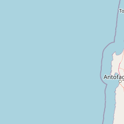
Map view of Morro Moreno National Park

Use this park location map to pinpoint Morro Moreno National Park in Chile, understand its exact geographic position, and read its mapped placement within the surrounding landscape more clearly.

Pigeon | © OpenStreetMap contributors

Location context for Morro Moreno National Park

Antofagasta Region
Recorded earthquake history

Explore the Historical Earthquake Record for Morro Moreno National Park

Review recorded seismic activity near Morro Moreno National Park to understand the historical context of the region. MoriAtlas provides a clear catalogue of associated earthquake events, including magnitude and epicenter data, for comprehensive geographical research into this protected coastal area.

Morro Moreno National Park Earthquake History

Catalogued events

244 events

Strongest magnitude

Magnitude 8

Most recent event

Jul 22, 2026

This history includes earthquakes recorded inside the park or within 50 km of its borders

Park atlas

Compare other Chilean protected areas, tracing diverse coastal desert and arid region geography.

Explore Nearby Protected Areas: Continuing Your Discovery from Morro Moreno National Park

After exploring Morro Moreno National Park, browse additional national parks and protected areas that share its distinctive coastal desert or arid regional context. Compare their unique conservation features, mapped geography, and protected landscapes to deepen your understanding of Chile's diverse natural heritage.
National parkAntofagasta Region
210 km away#1 closest

Southeast

Llullaillaco National Park: Mapped Volcanic Terrain and Protected Andean Landscape

Explore the high-altitude desert ecosystem and national park boundaries.

Llullaillaco National Park is a significant protected area in the Antofagasta Region, characterized by its striking volcanic landscape and high-altitude desert environment. The park's geography includes the towering Llullaillaco volcano, ancient ravines, and expansive semi-desert plains, forming a unique segment of the Central Andean dry puna ecoregion. Discover the mapped terrain and protected area context of this remarkable Chilean national park, offering insights into its arid-adapted biodiversity and geological significance.

Area
2,687 km²
IUCN
II
Relief
Mountain
Climate
Arid
National parkChile
261 km away#2 closest

South

Pan de Azúcar National Park: Chile's Protected Natural Landscape and Atlas Context

Discover mapped boundaries and regional geography for this national park.

Pan de Azúcar National Park is a protected area situated within Chile's diverse geography. This page provides detailed information on its status as a national park, focusing on its mapped boundaries and its contribution to the regional landscape context. Users can explore its geographic significance and understand its place within the broader atlas of protected areas.

Area
437.54 km²
Established
1985
IUCN
II
Relief
Mixed relief
Wildlife reservePotosí
279 km away#3 closest

East

Reserva nacional de fauna andina Eduardo Abaroa: Protected Area and Andean Terrain Map

High-altitude volcanic landscapes and flamingo wetlands in Potosí, Bolivia.

The Reserva nacional de fauna andina Eduardo Abaroa represents one of the most distinctive protected landscapes in the Andes. Spanning across the Altiplano, the terrain encompasses geothermal geyser fields at Sol de Mañana, dramatic volcanic summits like Licancabur, and specialized mineral lagoons. This protected area offers a look at extreme environmental adaptation, where high-altitude desert formations meet rare, nutrient-rich wetlands that sustain significant populations of Andean, James's, and Chilean flamingos.

Area
7,147.45 km²
Established
1973
IUCN
IV
Visitors
152.9K annual
Protected areaChile
About 388 km away#4 closest

Northeast

Salar del Huasco National Park: Chile's Unique Protected Landscape and Geographic Context

Explore its mapped terrain and protected area boundaries.

Salar del Huasco National Park represents a significant protected area within the geography of Chile. This destination provides detailed context for its mapped landscape and protected boundaries, offering insights into its regional geographic importance. It serves as a valuable entry for understanding specific protected lands and their contribution to the broader South American atlas.

National parkAtacama Region
404 km away#5 closest

South

Nevado Tres Cruces National Park: National Park in Atacama Region's Mapped Geography

Explore protected landscapes and regional park context.

Nevado Tres Cruces National Park is a significant protected national park situated within the Atacama Region of Chile. This entry provides essential geographic context, detailing the park's mapped boundaries and its contribution to the region's conservation landscape. Understand its place within the broader atlas of protected areas, focusing on the natural terrain and the distinct geography that characterize this important national park.

Area
591 km²
IUCN
II
Relief
Mountain
Climate
Alpine
National parkTarapacá Region
442 km away#6 closest

North

Volcán Isluga National Park: Protected Landscape Atlas and Geographic Context

Explore mapped boundaries and natural terrain in Tarapacá Region.

Volcán Isluga National Park stands as a distinct protected natural landscape in the Tarapacá Region of Chile. This MoriAtlas entry provides detailed insights into its geographic setting, mapped park boundaries, and the unique natural terrain it encompasses. It serves as a vital point for understanding the park's role within Chile's network of protected areas and its contribution to the regional geography.

Area
1,747 km²
Established
1967
IUCN
II
Relief
Mountain
National parkSalta Province
491 km away#7 closest

Southeast

Los Cardones National Park: National Park Protected Landscape in Salta Province

Explore the mapped geography and protected area boundaries.

Los Cardones National Park represents a distinct protected landscape within Salta Province, Argentina. This page provides an atlas-driven view of its status as a national park, focusing on its geographic setting and mapped boundaries. It is designed for users seeking structured information about the park's protected-area identity and its regional landscape context, offering a foundation for broader geographic exploration.

Area
650 km²
Established
1996
IUCN
II
Relief
Mixed relief
National parkAtacama Region
499 km away#8 closest

South

Llanos de Challe National Park: Unique Coastal Desert and Lomas Ecosystem

Atacama Region National Park with Dramatic Terrain and Wildlife

Llanos de Challe National Park presents a rare protected coastal desert environment within the Atacama Region. Its unique lomas ecosystem, sustained by coastal fog, supports a surprising diversity of life. The park encompasses striking geographic features, from unspoiled white-sand beaches to rugged mountainous terrain, offering a clear example of a vital protected landscape with significant guanaco populations and unique flora, all mapped within its regional context.

IUCN
II
Relief
Mixed relief
Climate
Arid
Scope
Mixed

Common questions about visiting, size, designation, and location context for Morro Moreno National Park

Morro Moreno National Park FAQs for park facts, access, geography, and protected area context

Find quick answers about Morro Moreno National Park, including protected-area facts, park geography, trail and visitor context, and how the park fits into its surrounding country and regional landscape.
MoriAtlas Explorer

Continue Your Protected Areas Search Across the Global Atlas

Deepen your exploration by continuing the structured search for national parks and protected areas worldwide. Utilize the comprehensive filtering capabilities to compare different conservation landscapes and refine your understanding of global park geography. Discover more about the distribution and characteristics of protected natural areas.

Global natural geography

