
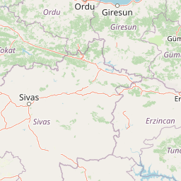
Mountain ranges
Park geography
Analyzing the regional landscape, boundary dimensions, and environmental features of Munzur Valley
Detailed Geography and Mapped Terrain Profile of Munzur Valley National Park in Turkey
This geographic profile details the physical characteristics of Munzur Valley National Park within the Tunceli Province of Turkey. Discover structured insights into the regional terrain, including recorded boundary dimensions covering 420 square kilometers and elevation data reaching 3300 meters. The record includes specific natural features like the Munzur Çayı, Mercan Deresi, and surrounding mountain ranges.
Related tags
Mountain ParksEastern AnatoliaNational ParksBiodiversity HotspotsForest Protected Areas
Turkey's largest and most biodiverse national park protecting a dramatic eastern Anatolian mountain valley
Munzur Valley National Park
Munzur Valley National Park is Turkey's largest national park, established in 1971 in the remote Tunceli Province of eastern Anatolia. The park encompasses approximately 420 square kilometers of dramatic mountain landscape centered on the Munzur Valley, which extends from near the city of Tunceli northward toward the Munzur Mountains rising to elevations around 3,300 meters. This protected area is recognized as one of the richest floristic regions in all of Anatolia, home to over 1,500 recorded plant species with significant endemism. The landscape features a complex geological composition of sedimentary, volcanic, and metamorphic rocks, traversed by the Munzur and Mercan rivers and punctuated by glacial lakes, travertines, hot springs, canyons, and waterfalls. The park's ecological significance is further enhanced by its location within the Eastern Anatolian deciduous forests ecoregion, making it a critical refuge for diverse wildlife populations including large mammals, birds, and fish species.
- Location
- Turkey
- Park type
- National park
- Established
- 1971
- Area
- 420 km²
- Highest point
- 3,300 m
Location overview
Regional setting and administrative alignment within Tunceli Province
Geographic Location of Munzur Valley National Park within Turkey
Munzur Valley National Park is officially situated inside Tunceli Province within the country of Turkey. Administrative records verify the protected area as an entirely inland, single-country terrestrial territory.
- Countries
- Turkey
- Regions
- Tunceli Province
- Primary location
- Tunceli Province
- Geographic setting
- Inland
Boundary and coordinates
Munzur Valley maps 420 km² of recorded land
Munzur Valley National Park mapped boundary and 420 km² land area
Munzur Valley National Park’s mapped extent covers 420 km², equal to its documented land area. This geometry provides a geographic frame for the park but does not replace official boundary sources.
- Boundary area
- 413.3 km²
- Boundary perimeter
- 145 km
- Northernmost point
- 39.4968° N
- Southernmost point
- 39.1134° N
- Easternmost point
- 39.5443° E
- Westernmost point
- 39.2662° E
- Geographic centre
- 39.3367° N, 39.3996° E
- North–south span
- 42.6 km
- East–west span
- 24 km
Elevation and terrain
Mountain relief metrics and recorded natural features
Munzur Valley National Park Terrain and Elevation Profile
Recorded terrain metrics establish the highest elevation point within the protected mountain landscape at 3300 meters. Associated feature cards detail river channels and mountain ranges located inside the park boundaries.
- Maximum elevation
- 3,300 m
- Highest point
- 3,300 m
Selected named natural features
Rivers
Mercan Deresi
Rivers
Munzur River
Mountain ranges
Munzur Mountains
Environmental setting
Temperate climate, mountain relief, and major water presence classifications
Environmental Setting and Classification Records for Munzur Valley National Park
Recorded landscape features and habitat types provide complementary interpretive categories for the physical setting of Munzur Valley National Park. Linked classification records connect stored environmental properties to relevant atlas destinations.
- Relief
- Mountain
- Climate
- Temperate
- Water
- Major water bodies
- Forest cover
- Mostly forested
- Seasonality
- Strongly seasonal
Landscape features
Mountains · Valleys · Canyon · Waterfalls · Forest · Lakes · Glacier · Rivers · Cave · Karst · Hills
Habitat types
Temperate broadleaf forest · Montane forest · Alpine meadow · Riverine habitat · Lacustrine habitat · Karst habitat
Park atlas
Trace the regional spread of protected landscapes and park geography across Eastern Anatolia, offering comparative insights.
Explore National Parks and Protected Areas Around Munzur Valley National Park, Eastern Anatolia
After exploring Munzur Valley National Park, browse nearby national parks and protected areas within Eastern Anatolia's diverse mountain landscapes and river valleys. Continue your atlas-style park discovery, comparing their unique ecological features, mountainous terrain, and conservation profiles across this distinct ecoregion.
National parkBayburt Province
About 107 km away#1 closest
Northeast

Mount Kop Defense National Historic Park: A Protected WWI Battlefield and Biodiversity Hotspot
Mapped protected area in Bayburt Province, Turkey.
Delve into Mount Kop Defense National Historic Park, a protected national park situated in the mountainous terrain of Bayburt Province, Turkey. This site is distinguished by its preserved World War I battlefield features and remarkable biodiversity, particularly its status as a critical habitat for numerous high-altitude butterfly species. Explore the mapped geography and unique conservation value of this significant protected landscape, understanding its distinct place within regional natural and historical atlases.
- Area
- 6.335 km²
- Established
- 2016
- IUCN
- II
- Relief
- Mountain
National parkTrabzon Province
About 136 km away#2 closest
North
Altındere Valley National Park: Discover its Dramatic Protected Landscape and Geography in Trabzon
Explore the unique cliff-side monastery and mountain terrain of this national park.
Altındere Valley National Park is a significant protected area within Turkey's Trabzon Province, renowned for its breathtaking geography. The park encompasses a dramatic valley in the Pontic Mountains, where the historic Sümela Monastery is famously situated on a sheer cliff face. Users can explore the mapped boundaries, distinct landscape features, and the regional context of this unique protected natural and cultural heritage site. This destination offers a compelling focus for understanding protected landscapes and their integration with the surrounding geography.
- Area
- 44.68 km²
- Established
- 1987
- IUCN
- II
- Relief
- Mountain
National parkTurkey
About 143 km away#3 closest
South
Mount Nemrut National Park: Turkey's Protected Landscape and Geographic Atlas Entry
Explore the mapped boundaries of this significant national park.
Mount Nemrut National Park is a designated national park in Turkey, offering a distinct focus for protected landscape and geographic discovery. This page serves as an entry point to understanding its mapped boundaries, regional setting within southeastern Anatolia, and its significance as a protected natural area. Delve into the atlas context and explore the unique geographic features that characterize this important Turkish national park.
- IUCN
- II
National parkTurkey
About 205 km away#4 closest
Northeast
Kaçkar Mountains National Park: Mapped Alpine Terrain in Turkey
Discover the dramatic glacial valleys and ridgelines.
Kaçkar Mountains National Park stands as a protected sentinel of Turkey's rugged alpine beauty. This national park encompasses dramatic peaks, glacier-carved valleys, and extensive highland meadows, offering a rich tapestry of mountain geography. Explore the mapped boundaries and landscape context of this iconic protected area, understanding its position within the broader topography of Turkey's Black Sea region.
- IUCN
- II
National parkSiirt Province
247 km away#5 closest
Southeast
Botan Valley National Park: Turkey's Largest National Park with Extensive Valley Landscape
Mapped Protected Area in Siirt Province, Southeastern Anatolia
Botan Valley National Park stands as Turkey's most significant protected area, renowned for its vast size and rich biodiversity. Centered around the dramatic Botan River valley in Siirt Province, the park offers a unique glimpse into southeastern Anatolia's rugged geography and diverse ecosystems. This atlas-focused entry allows for exploration of the park's mapped boundaries, its distinctive river valley landscape, and its role in regional nature conservation efforts.
- Area
- 486 km²
- Established
- 2019
- IUCN
- II
- Relief
- Mixed relief
National parkŞanlıurfa
About 254 km away#6 closest
South
Tek Tek Mountains National Park: Protected Area with Ancient Ruins in Şanlıurfa, Turkey
Mapped geography and historical landscapes within Turkey's southeastern steppe.
Tek Tek Mountains National Park represents a vital protected area in Şanlıurfa Province, southeastern Turkey. This national park safeguards a unique landscape defined by the Tek Tek mountain range, featuring rugged terrain, rocky outcrops, and semi-arid steppe ecosystems. Beyond its natural beauty, the park is renowned for its significant archaeological heritage, including ancient settlements and religious sites that offer a glimpse into the region's historical depth. MoriAtlas provides a structured atlas view of this protected landscape, detailing its geographic features and its place within the regional context.
- Area
- 193.35 km²
- Established
- 2007
- IUCN
- II
- Relief
- Mixed relief
National parkArtvin Province
About 269 km away#7 closest
Northeast
Hatila Valley National Park: Dramatic V-Shaped Valley and Volcanic Terrain in Artvin Province
Explore protected landscape, waterfalls, and botanical diversity.
Hatila Valley National Park represents a significant protected area within Artvin Province, Turkey, notable for its exceptionally steep, V-shaped river valley. This national park features a striking volcanic landscape characterized by deep gorges, numerous waterfalls, and unique geomorphological structures. Its rich botanical diversity, with 769 documented plant species including many endemics, positions it as a key site for understanding protected landscapes and regional flora. The park's geographic setting at the eastern end of the Kaçkar Mountains provides context for its Mediterranean climate and varied terrain.
- Area
- 169 km²
- Established
- 1994
- IUCN
- II
- Relief
- Mountain
National parkTurkey
About 283 km away#8 closest
Northeast
Sarıkamış-Allahuekber Mountains National Park: High-Altitude Protected Forest and WWI Memorial Landscape in Turkey
Explore the distinct protected terrain and historical geography of Turkey's eastern highlands.
Sarıkamış-Allahuekber Mountains National Park offers a unique exploration of high-altitude protected lands in Turkey. This national park is characterized by its remarkable pure Caucasian pine forests that thrive at elevations typically above the tree line, showcasing a rare alpine ecosystem. The park's rugged mountain terrain, marked by significant historical sites from the Battle of Sarikamish, provides a profound connection between natural landscape and human history within its mapped boundaries. Discover the geographic setting and protected status of this distinctive area.
- Area
- 225.19 km²
- Established
- 2004
- IUCN
- II
- Relief
- Mountain
MoriAtlas Explorer
Continue exploring the geographic context of Munzur Valley National Park
Delve deeper into the mapped terrain and regional geography surrounding Munzur Valley National Park. Understand its place within the Tunceli Province atlas and explore the protected landscape's unique characteristics. MoriAtlas provides structured data to connect this significant protected area with its broader geographic and ecological context, enabling a more complete understanding of Turkey's natural heritage.
Browse next
Global natural geography
Explore related park routes
Explore MoriAtlas Global ParksBrowse All MoriAtlas ParksGlobal Park Map DiscoveryMoriAtlas: Browse All CountriesBrowse All MoriAtlas ContinentsNational Park Environment AtlasGrand Canyon National Park AtlasYellowstone National Park AtlasYosemite National Park Atlas and GeographySerengeti National Park AtlasGalápagos National Park Protected LandscapeBanff National Park Geography and AtlasKruger National Park Atlas EntryUluṟu-Kata Tjuṯa National Park AtlasExplore Uluru-Kata Tjuta National Park GeographyPlitvice Lakes National Park AtlasFiordland National Park Protected LandscapeGreat Smoky Mountains National Park AtlasAfghanistan National Parks and Protected AreasAlbania National Parks and Protected AreasAlgeria National Parks and Protected AreasAmerican Samoa National Parks and Protected AreasAndorra National Parks and Protected AreasAngola National Parks and Protected AreasAntarctica National Parks and Protected AreasAntigua and Barbuda Park List