Mori Atlas logo
National parkNordre Isfjorden National Park

Discover the Arctic's dense seabird colonies and productive fjord ecosystems

Nordre Isfjorden National Park: Mapped Protected Landscape on Spitsbergen

Nordre Isfjorden National Park on Spitsbergen represents a significant protected Arctic coastline characterized by steep cliffs and tundra landscapes. Established to preserve this virgin polar environment, the park safeguards a unique interface where productive fjord waters support abundant wildlife, including vast seabird colonies. As a key protected area within Norway's Svalbard archipelago, it offers crucial insights into high Arctic ecology and landscape dynamics, serving as a vital point for geographic and atlas-based discovery.

Arctic national parksSvalbard protected areasCoastal ecosystemsSeabird coloniesFjord protectionArctic wildlife
Illustration of a coastal fjord with rocky shoreline, mountains, and water

Nordre Isfjorden National Park

National park

Park overview

Structured park overview, official facts, and landscape profile for Nordre Isfjorden National Park

Nordre Isfjorden National Park park facts, protected area profile, and essential visitor context
Review the core facts for Nordre Isfjorden National Park, including designation, size, terrain, visitor scale, habitats, and operating context in one park-focused overview.

About Nordre Isfjorden National Park

Nordre Isfjorden National Park represents one of Svalbard's most significant protected coastal environments, established in 2003 to safeguard a largely undeveloped Arctic fjord system and its associated terrestrial and marine ecosystems. The park encompasses the northern reaches of Isfjorden, extending across approximately 2,954 square kilometers of which roughly two-thirds is land and one-third is marine area. This designation reflects Norway's commitment to preserving representative examples of Svalbard's natural diversity, including both the terrestrial tundra habitats and the productive fjord waters that sustain them.

The park's defining characteristic is the nearly pristine coastal landscape that lines the northern shores of Isfjorden. Unlike many areas of Svalbard that bear traces of historical human activity—including mining operations, hunting stations, and research installations—the northern Isfjorden coastline has remained largely untouched. This relative remoteness has allowed natural processes to continue with minimal anthropogenic disturbance, preserving both the physical landscape and the ecological communities that depend on it. The dramatic Arctic coastline features cliffs, talus slopes, and coastal tundra that together create diverse microhabitats for wildlife.

Isfjorden itself is one of the most prominent geographic features in Svalbard, cutting deep into the interior of Spitsbergen and serving as a central ecological corridor for the archipelago. The fjord's orientation and bathymetry create unique hydrographic conditions that make it unusually productive for an Arctic marine environment. These conditions, combined with the protected status of the park, make Nordre Isfjorden an important area for understanding Arctic ecosystem function and for maintaining biodiversity in a region increasingly affected by climate change and other environmental pressures.

Quick facts and research context for Nordre Isfjorden National Park

Nordre Isfjorden National Park covers 2,954 square kilometers (2,050 km² land and 904 km² sea) on Spitsbergen Island in the Svalbard archipelago. Established in 2003, it protects a virgin coastal landscape along Isfjorden, one of Svalbard's largest fjords. The park lies north of Barentsburg, with Longyearbyen as the nearest settlement. The park is managed by Norway's Directorate for Nature Management and holds IUCN category II protected area status. The fjord's hydrographic conditions create unusually productive marine conditions for an Arctic environment, supporting dense concentrations of wildlife.

Park context

Deeper park guide and search-rich context for Nordre Isfjorden National Park

Nordre Isfjorden National Park history, landscape, wildlife, and travel context
Explore Nordre Isfjorden National Park through its history, landscape character, ecosystems, wildlife, conservation priorities, cultural context, and seasonal travel timing in a structured park guide built for atlas discovery and search intent.

Why Nordre Isfjorden National Park stands out

The park is best known for its remarkable seabird colonies that congregate along the coastal cliffs during breeding season, including massive gatherings of Brünnich's guillemot, little auk, Atlantic puffin, and black-legged kittiwake. The productive waters of Isfjorden, influenced by periodic inflows of warm Atlantic water, create conditions that sustain extraordinary concentrations of wildlife, plankton blooms support crustaceans, which in turn attract capelin and polar cod that feed the seabird colonies and marine mammals. This makes the park one of the most wildlife-dense areas in the Svalbard archipelago despite its high Arctic setting.

Mountainous landscape with snow-capped peaks, rocky slopes, and a large turquoise lake surrounded by hills with a blue fjord in the background under partly cloudy sky
View from Knutshøi towards central Jotunheimen

Nordre Isfjorden National Park history and protected-area timeline

Nordre Isfjorden National Park was established in 2003 as part of Norway's systematic expansion of protected areas across the Svalbard archipelago. The creation of this park reflected growing recognition of the ecological significance of Isfjorden and the need to preserve the relatively intact coastal ecosystems along its northern shores. Svalbard has been subject to international conservation agreements and Norwegian environmental policy that has progressively designated larger portions of the archipelago as protected areas, with Nordre Isfjorden representing one of the later additions to this network.

The establishment of the park occurred within the broader context of Svalbard's unique governance framework, which includes special provisions under the Svalbard Treaty that balance Norwegian sovereignty with international cooperation and environmental protection. The Directorate for Nature Management (now the Norwegian Environment Agency) was designated as the governing body responsible for managing the park, applying Norway's national park framework to protect the area's natural values while maintaining the overall wilderness character of the Svalbard environment. The park's creation built upon earlier conservation designations in Svalbard while filling a gap in protection for the Isfjorden region.

Nordre Isfjorden National Park landscape and geographic character

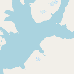
The landscape of Nordre Isfjorden National Park is defined by the dramatic interface between Arctic land and sea along the northern shores of Isfjorden. The coastline features a series of steep cliffs and rocky shores that rise from the water's edge, broken occasionally by smaller beaches and areas of talus where rockfall has created sloping debris fields. Behind the immediate coastline, the terrain transitions into undulating tundra that characterizes much of Spitsbergen's interior—gentle hills and valleys carved by ancient glaciation and now softened by permafrost and limited erosion.

The marine portion of the park encompasses the waters of Isfjorden itself, a fjord system that reaches significant depths and includes both open water areas and more sheltered coves. The fjord's configuration creates distinct hydrographic zones, with deeper central channels and shallower areas near the shore. Ice plays a significant role in the annual cycle—the fjord typically freezes over during the winter months, though the extent and duration of ice cover has been variable in recent decades due to changing climate conditions. The combination of steep coastal terrain, protected valleys, and productive marine waters creates a landscape of considerable scenic and ecological diversity within the high Arctic context.

Nordre Isfjorden National Park ecosystems, habitats, and plant life

The ecological character of Nordre Isfjorden National Park is defined by the unusual productivity of its marine waters relative to typical Arctic conditions. The periodic inflow of warm, saline Atlantic water into Isfjorden creates a stratification that promotes plankton blooms, establishing the base of a productive food web that supports extraordinary concentrations of wildlife. This hydrographic phenomenon distinguishes Isfjorden from many other Arctic fjords and makes it one of the most biologically productive areas in Svalbard.

The coastal tundra environments within the park support vegetation communities adapted to the harsh Arctic conditions—mosses, lichens, and specialized flowering plants that complete their growth cycles during the brief summer window. These plant communities, while not diverse in species terms, form essential habitat for the terrestrial elements of the park's ecosystem, including the Svalbard rock ptarmigan and seasonal goose populations. The interface between marine and terrestrial environments—the shoreline, cliffs, and adjacent tundra—creates a mosaic of habitats that supports both marine-feeding and terrestrial species, making the park ecologically significant as a place where multiple ecosystem types intersect.

Nordre Isfjorden National Park wildlife and species highlights

The wildlife of Nordre Isfjorden National Park is characterized by extraordinary concentrations of seabirds that gather along the coastal cliffs during the breeding season. The most abundant species include Brünnich's guillemot, which forms large breeding colonies on cliff ledges, the small and agile little auk that nests in rocky crevices, the distinctive Atlantic puffin with its colorful beak, and the graceful black-legged kittiwake that prefers more exposed cliff faces. These species often number in the thousands, creating a remarkable spectacle of colonial bird life that ranks among the most impressive in the Arctic.

The marine food web supporting these bird populations begins with the plankton that thrives in Isfjorden's productive waters. Copepods and other crustaceans graze on the plankton, building their own populations to immense densities. These crustaceans in turn sustain vast schools of capelin and polar cod, small fish that form the primary prey for seabirds and marine mammals. Glaucous gulls and northern fulmar scavenge throughout the area, while seasonal visitors include barnacle goose and pink-footed goose that use the coastal areas during migration. The Svalbard rock ptarmigan, a distinctive endemic subspecies, inhabits the terrestrial portions of the park. This concentration of wildlife, built on the foundation of the fjord's productive waters, makes the park a wildlife destination of unusual significance within the high Arctic.

Nordre Isfjorden National Park conservation status and protection priorities

Nordre Isfjorden National Park serves as an important conservation designation within the Svalbard protected area network, preserving both coastal and marine ecosystems that represent the archipelago's natural heritage. The park's IUCN Category II status reflects its designation as a national park aimed at protecting ecological processes and natural biodiversity while allowing for limited sustainable use in some areas. The protection encompasses the fjord waters and their productive food web, the coastal cliffs that support seabird colonies, and the terrestrial tundra habitats that together form a coherent Arctic ecosystem.

The significance of this conservation designation is amplified by the broader context of environmental change in the Arctic. Svalbard has experienced some of the most pronounced warming and environmental shifts in the polar regions, affecting ice conditions, species distributions, and ecosystem function. Protecting areas like Nordre Isfjorden helps maintain reference ecosystems where natural processes can continue with minimal human influence, providing both intrinsic value and scientific value for understanding Arctic environmental change. The park also contributes to Norway's international commitments under conventions including the Arctic Council framework and biodiversity agreements that recognize the importance of protecting representative Arctic ecosystems.

Nordre Isfjorden National Park cultural meaning and human context

Nordre Isfjorden National Park lies in an area with limited permanent human settlement, though human activity has shaped parts of the broader Isfjorden region. The settlement of Barentsburg, a Russian mining community, lies south of the park boundaries and represents the most significant human presence in the immediate vicinity. Longyearbyen, the largest settlement in Svalbard, lies to the northeast and serves as the administrative center for the archipelago. The park itself, however, contains no permanent settlements and represents one of the more remote and undeveloped portions of Svalbard's coast.

The cultural context of the park is primarily tied to the broader history of Svalbard as a place of exploration, resource extraction, and scientific research rather than indigenous habitation. The Svalbard archipelago has never supported permanent indigenous populations, though it has been visited by Norse explorers, Pomors, and later European scientific and economic expeditions over many centuries. Within this context, the northern Isfjorden area retains relatively little visible cultural heritage compared to some other parts of Svalbard where historical hunting stations, mining operations, and research installations have left more lasting marks on the landscape.

Top sights and standout views in Nordre Isfjorden National Park

The most compelling highlights of Nordre Isfjorden National Park center on its remarkable wildlife concentrations that thrive in an Arctic setting. The seabird colonies of Isfjorden—massive gatherings of Brünnich's guillemot, little auk, Atlantic puffin, and other species—represent one of the most impressive wildlife spectacles in Svalbard and the broader Arctic. These colonies depend on the fjord's unusually productive waters, where plankton blooms supported by Atlantic water inflows create a food web that sustains extraordinary densities of birds and marine life. The nearly pristine coastal landscape, relatively untouched by direct human activity, adds to the park's wilderness character and ecological significance.

Best time to visit Nordre Isfjorden National Park

Visiting Nordre Isfjorden National Park is shaped by the extreme Arctic conditions that characterize Svalbard's climate. The summer months of June through August offer the most accessible conditions, with the midnight sun providing continuous daylight and temperatures that, while cool, allow for outdoor activity. This is also the peak season for wildlife viewing, as seabird colonies are active during the breeding period and the fjord is ice-free. Winter visits are possible but present significant challenges, including extreme cold, limited daylight, and the need for specialized equipment and expertise to travel safely in the polar environment. The park's remote location requires planning through Longyearbyen, and visitors should be prepared for conditions that can change rapidly even during the summer season.

Park location guide

Geography guide, regional context, and park location map for Nordre Isfjorden National Park

Nordre Isfjorden National Park park geography, regions, and map view in Norway
Understand where Nordre Isfjorden National Park sits in Norway through a broader geographic reading of the surrounding landscape, nearby location context, and its mapped position within the national park landscape.

How Nordre Isfjorden National Park fits into Norway

Norway, officially the Kingdom of Norway, is a Nordic country in Northern Europe located on the Scandinavian Peninsula. It encompasses mainland Norway, the Arctic islands of Svalbard and Jan Mayen, and maintains dependencies including Bouvet Island and Antarctic claims. The country has a population of about 5.6 million and is bordered by Sweden, Finland, and Russia. Norway is a unitary parliamentary constitutional monarchy with Oslo as its capital and largest city.

Wider geography shaping Nordre Isfjorden National Park in Norway

Norway occupies the western and northern portions of the Scandinavian Peninsula in Northern Europe. The country shares a long eastern border with Sweden, and borders Finland and Russia to the northeast. Norway has an extensive coastline facing the Skagerrak, North Sea, Norwegian Sea, and Barents Sea. The terrain is predominantly mountainous with numerous fjords along the coastline.

Map view of Nordre Isfjorden National Park

Use this park location map to pinpoint Nordre Isfjorden National Park in Norway, understand its exact geographic position, and read its mapped placement within the surrounding landscape more clearly.

Pigeon | © OpenStreetMap contributors

Location context for Nordre Isfjorden National Park

SpitsbergenSvalbard

Discover the dramatic coastal terrain, expansive tundra, and productive marine protected areas within Svalbard.

Nordre Isfjorden National Park Photos: Visual Guide to Arctic Landscapes and Ecosystems
Visually explore the distinctive Arctic landscapes of Nordre Isfjorden National Park, including its rugged coastal cliffs, expansive tundra, and biologically rich fjord waters. These park images offer essential insights into the unique habitats supporting massive seabird colonies and diverse marine wildlife within this pristine protected area of Spitsbergen.

Mountainous landscape with snow-capped peaks, rocky slopes, and a large turquoise lake surrounded by hills with a blue fjord in the background under partly cloudy sky

Wide view of turquoise fjord water, rocky shoreline, and snow-capped mountains under cloudy sky

Park atlas

Expand your park discovery from Nordre Isfjorden, comparing other protected areas across Svalbard's unique Arctic geography.

Parks Near Nordre Isfjorden National Park: Compare Arctic Protected Areas in Svalbard
Explore other national parks and protected areas across Svalbard, revealing the rich diversity of Arctic coastal landscapes, productive fjords, and high tundra environments. Comparing these areas provides essential geographic context for understanding the broader conservation efforts and unique ecological features that define the archipelago's protected-area network.
National parkSvalbard

Sassen, Bünsow Land National Park: A Mapped Arctic Glacial Landscape in Svalbard

Explore protected boundaries and polar terrain.

Sassen, Bünsow Land National Park, located in the heart of Spitsbergen, Norway, showcases a quintessential Arctic wilderness defined by its expansive glacial features and deeply incised valleys. This protected area, part of the Svalbard archipelago, offers rich geographic context through its mapped terrain, highlighting glacial processes that have shaped the landscape. Discover the unique polar environment and the significance of this national park within the broader Norwegian Arctic atlas.

Area
1,230 km²
Established
2003
IUCN
II
Relief
Mountain
National parkSvalbard

Forlandet National Park: High Arctic Protected Landscape and Global Wildlife Limits

Explore mapped geography and protected ecosystem boundaries in Svalbard.

Forlandet National Park stands as a crucial element in the Arctic atlas, safeguarding the island of Prins Karls Forland and its surrounding marine territories. As the world's most northerly national park, it showcases a unique High Arctic landscape defined by stark coastal cliffs and vital waters supporting specialized wildlife. This protected area is recognized for harboring the most extreme northern populations of seals and common guillemots, making it a significant site for understanding polar ecosystems and conservation efforts within the Svalbard region.

Area
4,647 km²
Established
1973
IUCN
II
Relief
Lowland
National park

Indre Wijdefjorden National Park: Arctic Steppe and Fjord Protected Landscape Exploration

Mapped protected boundaries and unique terrain in Svalbard.

Discover the unique High Arctic steppe and dramatic fjord landscape of Indre Wijdefjorden National Park, a protected area in Svalbard, Norway. This park safeguards a rare ecosystem with endemic plant species, offering exceptional insights into Arctic geography and protected land conservation. Explore its mapped boundaries and distinct terrain, a key destination for atlas-based landscape discovery.

Area
1,127 km²
Established
2005
IUCN
II
Relief
Mountain
National parkSvalbard

Nordvest-Spitsbergen National Park: Protected Arctic Landscape and Geographic Atlas

Explore unique hot springs, glacial terrain, and polar expedition history.

Nordvest-Spitsbergen National Park, a protected national park in Norway's Svalbard archipelago, showcases dramatic Arctic geography. This page details its mapped landscapes, from volcanic terrains and glacial valleys to its famed northernmost hot springs. Discover the park's protected area status, its role in regional geography, and its historical significance for polar exploration, providing a rich context for atlas-based exploration.

Area
9,914 km²
Established
1973
IUCN
II
Relief
Mixed relief
National park

Sør-Spitsbergen National Park: Mapping Norway's Pristine Arctic Protected Landscape

Explore glacial terrain, tundra ecosystems, and significant seabird colonies.

Delve into Sør-Spitsbergen National Park, a cornerstone of Arctic protected areas within Norway's Svalbard archipelago. This extensive national park showcases raw glacial terrain, expansive ice caps, and sparse tundra valleys, offering a unique geographic context. It is globally recognized for its vast seabird colonies, particularly the dense nesting sites of thick-billed guillemots, and Ramsar-protected wetlands. Understanding Sør-Spitsbergen National Park through its mapped boundaries and landscape features provides critical insight into Arctic conservation and natural processes.

Area
8,504 km²
Established
1973
IUCN
II
Relief
Mixed relief
National parkFinnmark

Seiland National Park: Arctic Island Landscape and Northernmost Scandinavian Glaciers

Mapped boundaries of protected terrain in Finnmark

Seiland National Park offers a distinct glimpse into Arctic island geography, renowned for protecting Scandinavia's northernmost glaciers. This protected area in Finnmark features a dramatic landscape shaped by glaciated mountains, deep coastal fjords, and alpine terrain, making it a key destination for understanding Nordic natural environments. MoriAtlas facilitates exploration of its mapped boundaries and the unique combination of glacial and marine ecosystems present.

Area
316 km²
Established
2006
IUCN
II
Relief
Mountain
National park

Stabbursdalen National Park: Protected Arctic Landscape and Northernmost Pine Forest Atlas

Explore Finnmark's unique geography and protected terrain.

Stabbursdalen National Park preserves a remarkable ecological boundary, featuring the planet's northernmost Scots pine woodland within a dramatic Arctic landscape. This protected area offers a deep dive into rugged mountain terrain, river valley formations, and vital wetland habitats. As a key component of Norway's protected lands, it provides essential context for understanding regional geography and the limits of forest ecosystems on the mapped landscape.

Area
747 km²
Established
1970
IUCN
II
Relief
Mixed relief
National parkFinnmark

Varangerhalvøya National Park: Explore Finnmark's Unique Subarctic Protected Landscape

Mapped tundra, wetlands, and Arctic fox conservation.

Varangerhalvøya National Park offers a compelling atlas exploration of Norway's northeasternmost protected landscapes. This national park in Finnmark is distinguished by its subarctic terrain, featuring expansive tundra, diverse wetlands, and a unique ecological position where multiple biomes converge. It is a critical habitat for the Arctic fox and a vital Important Bird Area, providing deep insights into protected area geography and landscape context for those studying regional conservation and natural formations.

Area
1,804.1 km²
Established
2006
IUCN
II
Relief
Lowland

Common questions about visiting, size, designation, and location context for Nordre Isfjorden National Park

Nordre Isfjorden National Park FAQs for park facts, access, geography, and protected area context
Find quick answers about Nordre Isfjorden National Park, including protected-area facts, park geography, trail and visitor context, and how the park fits into its surrounding country and regional landscape.
MoriAtlas Explorer

Continue Your Protected Areas Search Across the Global Atlas

Deepen your exploration by continuing the structured search for national parks and protected areas worldwide. Utilize the comprehensive filtering capabilities to compare different conservation landscapes and refine your understanding of global park geography. Discover more about the distribution and characteristics of protected natural areas.

Global natural geography