Mori Atlas logo
National parkStabbursdalen National Park

Mapping the unique geography and protected terrain of Norway's Finnmark region.

Stabbursdalen National Park: World's Northernmost Pine Forest & Arctic Protected Landscape

(Stabbursdalen nasjonalpark)

Stabbursdalen National Park represents a crucial protected landscape in northern Norway, safeguarding the world's northernmost Scots pine forest—a remnant of ancient woodland surviving in a unique Arctic valley. This national park offers a detailed geographic study of barren mountain plateaus, deep ravines, and the vital Stabburselva river system. Its existence highlights the extreme limits of forest ecosystems, providing essential context for regional landscape and terrain discovery within the Finnmark county.

Northernmost pine forestArctic landscapeFinnmarkProtected areaRiver valleyWetlands

Stabbursdalen National Park

National park

Park overview

Structured park overview, official facts, and landscape profile for Stabbursdalen National Park

Stabbursdalen National Park park facts, protected area profile, and essential visitor context
Review the core facts for Stabbursdalen National Park, including designation, size, terrain, visitor scale, habitats, and operating context in one park-focused overview.

About Stabbursdalen National Park

Stabbursdalen National Park occupies a dramatic landscape in the far north of Norway, where Arctic tundra and boreal forest meet at the very edge of tree growth. The park is centered on the Stabburselva river, which flows from the mountains through a valley carved by ancient glacial forces, creating a landscape of narrow ravines, cascading waterfalls, and wide meandering bends where the river sweeps into shallow bays at Luobbal. The surrounding terrain consists of bare, rugged mountains to the southeast and ancient, undulating hills to the north and west. This combination of features creates a park of stark contrasts, where barren plateau landscapes meet fertile wetland oases and scattered woodland.

The park's global significance stems from its ecological uniqueness. The protection of the northernmost pine forest on Earth is the primary conservation objective, but the park also preserves a representative sample of Finnmark's diverse landscapes. The Stabburselva river ecosystem, with its series of rapids and deep still pools, supports a rich aquatic environment, while the wetlands at Luobbal provide a crucial habitat for breeding waterfowl in an otherwise sparsely populated landscape. The park's boundaries include a small corner extending into Hammerfest Municipality, reflecting the ecological continuity of the wider landscape.

Quick facts and research context for Stabbursdalen National Park

Stabbursdalen National Park is located in North Norway, approximately 120 kilometers west of Alta. The park encompasses 747 km² of Finnmark's characteristic Arctic landscape including barren mountains, open plateaus, and the Stabburselva river valley. It was established in 1970 as a 98 km² forest reserve and expanded to its current size in 2002. The park is notable for containing the world's northernmost pine forest, representing the southernmost survivors of a once more widespread boreal ecosystem that retreated as climate cooled.

Park context

Deeper park guide and search-rich context for Stabbursdalen National Park

Stabbursdalen National Park history, landscape, wildlife, and travel context
Explore Stabbursdalen National Park through its history, landscape character, ecosystems, wildlife, conservation priorities, cultural context, and seasonal travel timing in a structured park guide built for atlas discovery and search intent.

Why Stabbursdalen National Park stands out

The park is exceptional for protecting the world's northernmost Scots pine forest, a relict ecosystem that represents the extreme northern limit of tree growth in the Northern Hemisphere. This pine woodland, surviving in a sheltered valley, is the remnant of forests that spread far inland during warmer climatic periods thousands of years ago. The woodland is open with low, wind-shaped pine trees, growing slowly in the harsh Arctic conditions on dry, lichen-covered soil. This makes Stabbursdalen a living laboratory for understanding forest ecosystem limits and climate-driven vegetation changes.

Twisted Scots pine tree standing in a grassy, hilly landscape with other trees in the background.
Scots pine tree in Stabbursdalen National Park.

Stabbursdalen National Park history and protected-area timeline

Stabbursdalen was first established as a protected area on February 6, 1970, originally protecting a 98-square-kilometer area of pine forest surrounding the Stabburselva river. At the time of establishment, the focus was specifically on preserving this remarkable northernmost pine forest, which had long been recognized as botanically significant. The initial protected area, while smaller than today, recognized the ecological importance of this northern woodland remnant.

In 2002, the park underwent a major expansion, growing to its current size of 747 square kilometers. This expansion reflected a broader understanding of the need to protect not just the pine forest itself but the entire watershed and landscape context that sustained it. The expansion also incorporated additional representative landscapes of Finnmark, including mountain plateaus, ravines, and wetlands, creating a more comprehensive protected area that could sustain ecological processes at a larger scale. The governing body is the County Governor of Finnmark, which manages the park in coordination with local interests.

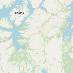
Stabbursdalen National Park landscape and geographic character

The physical landscape of Stabbursdalen National Park showcases the characteristic terrain of Finnmark in northern Norway. The park encompasses a complex topography dominated by barren mountains and open plateaus, with narrow ravines cutting through the higher terrain. The Stabburselva river is the central hydrological feature, flowing through the park in a series of distinct segments: cascading over rocky ledges as waterfalls, rushing through narrow channels as rapids, and pooling in deep still bends where the terrain flattens. At Luobbal, also known as Lompola, the river widens and flows gently into wide, shallow bays.

To the southeast, the bare and rugged mountains of Gaissene present a dramatic backdrop of exposed rock and steep terrain. In contrast, the terrain to the north and west is characterized by ancient, undulating hills worn smooth by millennia of weathering. The valley floor itself supports the park's most distinctive feature—the ribbon of pine woodland that follows the river's course—while the surrounding hills are covered in mountain birch and open tundra. The combination of water, woodland, and mountain creates a visually striking Arctic landscape of considerable diversity.

Stabbursdalen National Park ecosystems, habitats, and plant life

The ecological character of Stabbursdalen is defined by the tension between boreal and Arctic ecosystems meeting at the northern limit of tree growth. The park's botanical centerpiece—the Scots pine forest—represents a relict ecosystem that dates to the Holocene thermal period when climate was warmer and pine forests spread far inland along the fjords and valleys of northern Norway. As temperatures declined, the forest retreated to the most sheltered valleys where conditions remained suitable, and Stabbursdalen represents one of these final strongholds.

The pine woodland is open and sparse, characterized by low, shrubby trees shaped by wind and frost. The trees grow slowly in the harsh conditions, and the dry, sterile soils can only support a poor undergrowth of lichen and heather. This creates a distinctive landscape of wind-stunted trees growing on a carpet of Arctic mosses and lichens. At Luobbal, the wetlands form a remarkable fertile oasis amid the barren terrain, where willow and sedge grow thick along the riverbanks, supporting a much richer plant community than the surrounding hills. This contrast between the open pine woodland, the wetland meadows, and the barren mountain slopes creates a mosaic of habitats within a relatively compact area.

Stabbursdalen National Park wildlife and species highlights

Stabbursdalen National Park supports a diverse bird community that depends on the park's varied habitats. The wetlands at Luobbal are particularly important as breeding grounds, especially for ducks and other waterfowl that nest in the dense vegetation along the river. The park marks the most northerly habitat limit for several species, including black grouse, which inhabits the interface between woodland and open terrain, and osprey, which hunts along the river and pools. The old, hollow pine trees provide ideal nesting cavities for goldeneye and goosander, diving ducks that require tree cavities for breeding.

The surrounding mountains and plateaus support Arctic species adapted to the harsh conditions, while the river itself contains populations of Arctic char and other cold-water fish. Historically, the area supported populations of wild reindeer, with pit-fall traps evidence of traditional hunting practices, though domestic reindeer herding became the dominant use from the 17th century onward. Today, the reindeer still use the area for summer grazing, maintaining the traditional connection between the Sami people and this landscape.

Stabbursdalen National Park conservation status and protection priorities

Stabbursdalen National Park represents one of the most northerly protected areas in Europe and serves multiple conservation objectives. The protection of the world's northernmost pine forest is the park's defining mission, as this ecosystem represents a critical relict of boreal forest that once covered much wider areas during warmer climatic periods. Preserving this forest allows for the study of ecosystem dynamics at the edge of tree growth and provides a reference point for understanding climate change impacts on northern ecosystems.

Beyond the pine forest, the park conserves representative samples of Finnmark's diverse landscapes, from mountain plateaus to river valleys and wetlands. The wetlands are particularly important for migratory birds, serving as crucial breeding and staging areas in the Arctic. The protection of the Stabburselva watershed ensures the integrity of the river ecosystem, including its fisheries and the riparian habitats that depend on natural flow regimes. The expansion in 2002 reflected an ecosystem-based approach to protection, recognizing that isolated forest reserves needed to be embedded within larger landscapes to sustain their ecological values.

Stabbursdalen National Park cultural meaning and human context

The landscape of Stabbursdalen has been shaped by centuries of human use by the Sami people, particularly the coastal Sami (sjøsamene) who relied on the valley's natural resources for their subsistence. Traditional activities included hunting, fishing, and collecting animal fodder, practices that left few visible traces in the landscape through careful, sustainable harvesting. At Luobbal, sedge was historically cut for winter fodder for livestock, while the forest provided timber for building boats and houses. The remains of pit-fall traps, used to hunt wild reindeer, can still be found in the terrain, though domestic reindeer herding became prevalent from the 17th century onward. Today, the park area provides summer grazing for reindeer, maintaining this traditional use. The valley's name reflects a complex history—originally named "Tabors dal" by an 18th-century missionary after Mount Tabor, it was later folk-etymologized as "Stabbursdalen," incorrectly assuming the first element came from "stabbur," a type of storehouse, though no such building ever existed in the valley.

Top sights and standout views in Stabbursdalen National Park

Stabbursdalen National Park offers a rare glimpse into the extreme limits of forest ecosystems in the Northern Hemisphere. The world's northernmost pine forest remains the park's most distinctive feature, a living remnant of warmer times now preserved for scientific study and ecological value. The contrast between the open, wind-shaped pine woodland and the barren mountain plateaus creates a visually striking Arctic landscape. The Stabburselva river, with its waterfalls, rapids, and quiet pools, provides the scenic spine of the park and supports rich wetland habitats at Luobbal. The park serves as an important area for Arctic birdlife, with species at the northern limit of their range finding suitable breeding habitat. The cultural heritage of the Sami people, whose traditional use shaped the landscape over centuries, adds historical depth to the natural values.

Best time to visit Stabbursdalen National Park

The optimal season for visiting Stabbursdalen National Park is during the Arctic summer, from late June through August, when temperatures are mildest and daylight is extensive. The long days of the midnight sun period allow extended exploration of the park's landscapes, and the relatively warm conditions make outdoor activities more comfortable. Summer is also the best season for wildlife observation, particularly birds, as breeding activity is at its peak and species are most active. The river is accessible for fishing during this period, and the wetlands are alive with waterfowl. Winter visits are challenging due to extreme cold, limited daylight, and difficult access conditions, though the snow-covered landscape offers a different perspective on this northern environment. Spring and autumn provide transitional conditions with variable weather and more limited services.

Park location guide

Geography guide, regional context, and park location map for Stabbursdalen National Park

Stabbursdalen National Park park geography, regions, and map view in Norway
Understand where Stabbursdalen National Park sits in Norway through a broader geographic reading of the surrounding landscape, nearby location context, and its mapped position within the national park landscape.

How Stabbursdalen National Park fits into Norway

Norway, officially the Kingdom of Norway, is a Nordic country in Northern Europe located on the Scandinavian Peninsula. It encompasses mainland Norway, the Arctic islands of Svalbard and Jan Mayen, and maintains dependencies including Bouvet Island and Antarctic claims. The country has a population of about 5.6 million and is bordered by Sweden, Finland, and Russia. Norway is a unitary parliamentary constitutional monarchy with Oslo as its capital and largest city.

Wider geography shaping Stabbursdalen National Park in Norway

Norway occupies the western and northern portions of the Scandinavian Peninsula in Northern Europe. The country shares a long eastern border with Sweden, and borders Finland and Russia to the northeast. Norway has an extensive coastline facing the Skagerrak, North Sea, Norwegian Sea, and Barents Sea. The terrain is predominantly mountainous with numerous fjords along the coastline.

Map view of Stabbursdalen National Park

Use this park location map to pinpoint Stabbursdalen National Park in Norway, understand its exact geographic position, and read its mapped placement within the surrounding landscape more clearly.

Pigeon | © OpenStreetMap contributors

Location context for Stabbursdalen National Park

FinnmarkPorsanger Municipality

Visual Research into Stabbursdalen's Unique Arctic Terrain, Northernmost Scots Pine Forest, and Protected-Area Habitats

Stabbursdalen National Park Photos: Explore Arctic Landscapes, Pine Forests, and River Scenery
Browse comprehensive imagery of Stabbursdalen National Park to understand its unique Arctic terrain, including the world's northernmost Scots pine forest, barren mountain plateaus, and winding Stabburselva river. These visual assets provide essential context for tracing the park's distinct landscape character, ecological significance, and the varied habitats within this remarkable protected area of Finnmark.

Twisted Scots pine tree standing in a grassy, hilly landscape with other trees in the background.

A mountainous landscape featuring a turquoise lake, rocky terrain, and snow-capped peaks under a partly cloudy sky

Park atlas

Trace the unique Arctic landscapes and conservation efforts across Finnmark and northern Norway's diverse terrain.

Discover More National Parks and Protected Areas Near Stabbursdalen National Park
After exploring Stabbursdalen National Park, continue your geographic discovery by tracing other protected areas across Finnmark and northern Norway's extensive Arctic region. Compare diverse landscapes, from unique Scots pine forests to barren mountain plateaus and significant river valleys, to understand the broader regional park geography and conservation patterns.
National parkFinnmark

Seiland National Park: Arctic Island Landscape and Northernmost Scandinavian Glaciers

Mapped boundaries of protected terrain in Finnmark

Seiland National Park offers a distinct glimpse into Arctic island geography, renowned for protecting Scandinavia's northernmost glaciers. This protected area in Finnmark features a dramatic landscape shaped by glaciated mountains, deep coastal fjords, and alpine terrain, making it a key destination for understanding Nordic natural environments. MoriAtlas facilitates exploration of its mapped boundaries and the unique combination of glacial and marine ecosystems present.

Area
316 km²
Established
2006
IUCN
II
Relief
Mountain
National parkTroms

Reisa National Park: Dramatic River Valley and Protected Landscape Atlas

Subarctic terrain and geographic context in Troms, Norway.

MoriAtlas offers detailed geographic context for Reisa National Park, a protected landscape in Norway's Troms county. Explore the park's identity as a significant subarctic river valley, carved by the Reisa River into a dramatic canyon system. This page provides insights into its mapped natural features, regional landscape setting, and its importance within the broader atlas of protected areas. Understand the park's protected boundaries and terrain for structured geographic discovery.

Area
803 km²
Established
1986
IUCN
II
Relief
Mixed relief
National parkKarasjok Municipality

Anárjohka National Park: Mapped Subarctic Wilderness and Protected Landscape

Explore Norway's Finnmarksvidda plateau geography.

Anárjohka National Park, a protected area in Norway's Finnmark region, offers a compelling atlas-level view of subarctic wilderness. The park's landscape is defined by its location on the Finnmarksvidda plateau, featuring rolling birch woodlands, open pine barrens, and extensive wetlands, all mapped within its protected boundaries. This park provides a crucial point of discovery for understanding regional geography, natural terrain, and the interconnectedness of protected lands across northern Europe.

Area
1,409 km²
Established
1976
IUCN
II
Relief
Mixed relief
National parkFinland

Lemmenjoki National Park: Finland's Protected Landscape Geography

Explore mapped park boundaries and regional natural context.

Lemmenjoki National Park is a vital protected area situated within Finland's vast northern geography. This page details its designation as a national park, offering a clear view of its mapped boundaries and landscape character. Users can explore the park's geographic context within Finland and understand its contribution to the region's network of conservation lands, facilitating structured atlas-style discovery.

Area
2,850 km²
Established
1956
IUCN
Ib
Visitors
21.1K annual
National park

Øvre Pasvik National Park: Norway's Pristine Siberian Taiga & Mapped Boreal Geography

Explore ancient forests, wetlands, and transboundary protected landscapes.

Øvre Pasvik National Park is a landmark protected area in Northern Norway, showcasing a remarkably intact Siberian taiga ecosystem characterized by ancient Scots pine forests and extensive wetlands. This national park offers a unique geographic perspective with its notably flat terrain, distinguishing it within the broader Norwegian atlas. As part of the Pasvik, Inari Trilateral Park, it highlights significant transboundary conservation efforts and provides a valuable mapped resource for understanding European boreal landscapes and their unique wildlife habitats.

Area
119 km²
Established
1970
IUCN
II
Relief
Lowland
National parkFinnmark

Varangerhalvøya National Park: Explore Finnmark's Unique Subarctic Protected Landscape

Mapped tundra, wetlands, and Arctic fox conservation.

Varangerhalvøya National Park offers a compelling atlas exploration of Norway's northeasternmost protected landscapes. This national park in Finnmark is distinguished by its subarctic terrain, featuring expansive tundra, diverse wetlands, and a unique ecological position where multiple biomes converge. It is a critical habitat for the Arctic fox and a vital Important Bird Area, providing deep insights into protected area geography and landscape context for those studying regional conservation and natural formations.

Area
1,804.1 km²
Established
2006
IUCN
II
Relief
Lowland
Watercolor painting showing rolling hills, forests, and distant mountains under a soft sky
National parkLapland

Pallas-Yllästunturi National Park: Lapland's Premier Protected Fell Landscape for Atlas Exploration

Explore its ancient mountain geography and mapped protected area.

Pallas-Yllästunturi National Park presents a unique atlas of Lapland's ancient geography, characterized by a vast chain of rounded fells that are the remnants of three-billion-year-old mountains. As Finland's most popular national park, it offers a deep dive into protected landscape discovery, showcasing diverse boreal forests, mires, and exceptional fell terrain. Understand its geographic scope and protected boundaries for comprehensive map-based exploration.

Area
1,020 km²
Established
2005
IUCN
II
Visitors
598.8K annual
National parkLapland

Urho Kekkonen National Park: Detailed Map and Protected Landscape Exploration in Lapland

Discover Finland's expansive Arctic wilderness and fell terrain.

Urho Kekkonen National Park represents a significant portion of Finland's protected Arctic landscape, offering a rich opportunity for geographic and atlas-based discovery. This national park in Lapland showcases dramatic fell formations, boreal forests, and extensive wetlands, with mapped boundaries that define its wild eastern reaches and more accessible western trails. Users can explore the unique terrain and understand its place within the broader regional geography, appreciating the vastness of this protected natural area.

Area
2,550 km²
Established
1983
IUCN
II
Visitors
435.9K annual

Common questions about visiting, size, designation, and location context for Stabbursdalen National Park

Stabbursdalen National Park FAQs for park facts, access, geography, and protected area context
Find quick answers about Stabbursdalen National Park, including protected-area facts, park geography, trail and visitor context, and how the park fits into its surrounding country and regional landscape.
MoriAtlas Explorer

Continue Your Protected Areas Search Across the Global Atlas

Deepen your exploration by continuing the structured search for national parks and protected areas worldwide. Utilize the comprehensive filtering capabilities to compare different conservation landscapes and refine your understanding of global park geography. Discover more about the distribution and characteristics of protected natural areas.

Global natural geography