Mori Atlas logo
National parkVarangerhalvøya National Park

Map exploration of unique tundra, wetlands, and critical Arctic fox habitat.

Varangerhalvøya National Park: A Distinctive Subarctic Protected Landscape in Finnmark

(Varangerhalvøya nasjonalpark)

Varangerhalvøya National Park, situated in the far northeast of Norway within Finnmark county, protects a remarkable subarctic landscape spanning approximately 1,804 square kilometers. Established in 2006, this national park is characterized by undulating tundra, extensive wetlands, and a unique geographical position at the convergence of Arctic, boreal, and Siberian ecosystems. It represents a vital area for biodiversity, notably serving as a crucial sanctuary for Norway's only viable Arctic fox population and significant bird colonies, offering a profound context for protected area and landscape discovery.

National ParkNorwayArcticSubarcticTundraWetlands

Varangerhalvøya National Park

National park

Park overview

Structured park overview, official facts, and landscape profile for Varangerhalvøya National Park

Varangerhalvøya National Park park facts, protected area profile, and essential visitor context
Review the core facts for Varangerhalvøya National Park, including designation, size, terrain, visitor scale, habitats, and operating context in one park-focused overview.

About Varangerhalvøya National Park

Varangerhalvøya National Park protects a landscape of extraordinary ecological and cultural significance at Norway's northeastern frontier. The Varanger Peninsula, the park's core, represents a transitional environment where the true Arctic gives way to boreal conditions, creating a mosaic of tundra, heath, and sparse woodland that defines subarctic Scandinavia. The park's establishment in 2006 recognized the need to preserve this distinctive environment, which had long served as a reminder of Norway's Arctic heritage despite its location on the mainland. The area's isolation has proven advantageous for conservation, maintaining viable populations of species that have declined elsewhere in Scandinavia. Beyond its ecological importance, the peninsula has supported human communities for centuries, with fishing and traditional land use practices shaping both the landscape and its cultural identity. The park's management balances these human dimensions with the imperative to protect the Arctic and subarctic ecosystems that make this region distinctive within European conservation contexts.

Quick facts and research context for Varangerhalvøya National Park

Varangerhalvøya National Park lies in Finnmark county, Norway's northernmost region, protecting the Varanger Peninsula that juts into the Barents Sea. The park was established in 2006 and covers 1,804.1 square kilometers across four municipalities. It is managed by the Norwegian Directorate for Nature Management and holds IUCN Category II protection status. The peninsula's position at the confluence of climatic zones has produced distinctive vegetation patterns, including some of the world's northernmost deciduous woodlands. The area supports Norway's most endangered mammal species, the Arctic fox, and has been designated an Important Bird Area by BirdLife International.

Park context

Deeper park guide and search-rich context for Varangerhalvøya National Park

Varangerhalvøya National Park history, landscape, wildlife, and travel context
Explore Varangerhalvøya National Park through its history, landscape character, ecosystems, wildlife, conservation priorities, cultural context, and seasonal travel timing in a structured park guide built for atlas discovery and search intent.

Why Varangerhalvøya National Park stands out

Varangerhalvøya is best known for its remarkable position at the crossroads of Arctic and boreal ecosystems, creating a unique blend of tundra, wetland, and northern woodland habitats. The peninsula hosts Norway's only viable Arctic fox population, which has been the focus of intensive conservation efforts including red fox control programs. The park's Important Bird Area designation reflects its significance for breeding populations of Arctic waterfowl, waders, and birds of prey, including lesser white-fronted geese, long-tailed ducks, and snowy owls. The limestone-rich geology in the northern portions supports rare plant species at the extreme edge of their ranges, while the traditional practice of fish drying on wooden racks remains visible across the landscape, reflecting the area's continuing connection to maritime livelihoods.

A panoramic view of a mountainous landscape with turquoise lakes, snow-capped peaks, rocky terrain, and a winding river under a partly cloudy sky
Panoramic view of turquoise glacial lakes and snow-capped mountains in a rugged alpine landscape

Varangerhalvøya National Park history and protected-area timeline

Varangerhalvøya National Park was established in 2006 as part of Norway's ongoing effort to protect representative examples of the country's diverse natural landscapes. The Varanger Peninsula had long been recognized for its ecological significance, but formal protection was prioritized as development pressures and climate change began affecting subarctic ecosystems across the region. The park was designated under Norwegian law and placed under the management of the Directorate for Nature Management, which coordinates conservation efforts across Norway's protected areas. The establishment process involved coordination among the four municipalities whose territories the park encompasses, reflecting the local governance structures that characterize Norwegian conservation management. Prior to national park designation, parts of the area had received other forms of protection, and the national park status elevated the conservation framework to the highest category under Norwegian law.

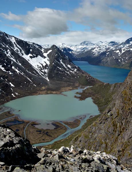
Varangerhalvøya National Park landscape and geographic character

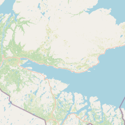
The Varanger Peninsula presents a landscape of subtle but compelling beauty, characterized by undulating tundra, scattered lakes, and a coastline that alternates between steep cliffs and gentle beaches. The terrain rises gradually from sea level to approximately 300-400 meters, with the highest ground supporting alpine tundra vegetation that becomes increasingly sparse and stunted toward the exposed summits. The underlying geology features significant limestone deposits in the northern areas, creating more alkaline conditions that support distinctive plant communities. The coastline is indented with small inlets and bays where the Varangerfjord meets the Barents Sea, and the eastern shores face directly toward the Russian border across the open water. The landscape lacks the dramatic mountain peaks found in other Norwegian national parks, but its expansive horizons, changing light, and vast wetland systems create a sense of Arctic wilderness that is uniquely characteristic of Finnmark.

Varangerhalvøya National Park ecosystems, habitats, and plant life

The ecological character of Varangerhalvøya reflects its position at the southern margin of true Arctic environments. The peninsula's plant life is distinguished by the convergence of species from multiple biogeographic origins—Arctic taxa from the north, eastern Siberian elements from across the Barents Sea, and more southerly boreal species that reach their northern limits here. The small deciduous woodlands found in sheltered valleys represent some of the northernmost forest patches in the world, consisting primarily of birch and willows that form krummholz at their exposed edges. The lime-rich soils in the northern areas support specialized plant communities including rare poppy species and sandworts that are adapted to alkaline substrates. Wetland systems are extensive across the peninsula, with bogs, mires, and marshy areas providing critical habitat for breeding birds and supporting the broader food web that characterizes subarctic ecosystems.

Varangerhalvøya National Park wildlife and species highlights

The wildlife of Varangerhalvøya represents a remarkable assembly of Arctic and subarctic species, some of which are found nowhere else in Norway. The Arctic fox stands as the park's most significant conservation priority—this small predator represents Norway's only viable population of a species that has been driven from most of its former European range. Conservation programs have focused on reducing competition from red foxes, with notable success reported through 2008. The peninsula also supports populations of wolverine and domesticated reindeer, the latter representing traditional herding practices that have shaped the landscape. The bird fauna is exceptionally diverse during the breeding season, with the peninsula supporting important populations of waterfowl, waders, and birds of prey. Species such as the lesser white-fronted goose, long-tailed duck, and various sandpiper species nest here in significant numbers, while snowy owls and gyrfalcons hunt the tundra during the brief Arctic summer.

Varangerhalvøya National Park conservation status and protection priorities

Varangerhalvøya National Park represents one of Norway's most important conservation areas for Arctic and subarctic biodiversity. The park's designation as an Important Bird Area by BirdLife International acknowledges its significance for breeding bird populations, particularly Arctic waterfowl and waders whose populations are declining across their ranges. The Arctic fox conservation program represents one of Norway's most ambitious species recovery efforts, requiring ongoing management intervention to maintain viable populations in the face of competition and climate pressures. The limestone-rich areas support plant species of conservation concern, including populations at the very edge of their global distributions. The park contributes to Norway's commitments to preserve representative examples of its natural heritage and provides a reference area for understanding subarctic ecosystem dynamics in a changing climate.

Varangerhalvøya National Park cultural meaning and human context

The Varanger Peninsula has supported human communities for generations, with fishing playing a central role in local economies and cultural identity. The distinctive wooden racks used to dry fish visible across the peninsula reflect traditional practices that continue in the region, maintaining connections between contemporary communities and historical land-use patterns. The area lies within traditional territory associated with Sami, Norwegian, and Kven cultures, each contributing to the region's distinctive character. The park's establishment required balancing conservation objectives with the ongoing needs of communities whose livelihoods depend on the landscape, including reindeer herding that remains important in parts of the peninsula. The multiple language names for the park—reflecting Norwegian, Northern Sami, and Kven—acknowledge this cultural complexity and the multi-ethnic character of Finnmark.

Top sights and standout views in Varangerhalvøya National Park

Varangerhalvøya stands out for its position at the crossroads of Arctic and boreal Europe, hosting species assemblages found nowhere else in mainland Norway. The peninsula's Arctic fox population represents Norway's last hope for maintaining this endangered species in the wild. Bird populations are exceptional, with the park supporting breeding grounds for species including lesser white-fronted geese, long-tailed ducks, and numerous wader species. The northernmost deciduous woodlands in the world occur here, while limestone bedrock creates specialized habitats for rare plant species. The landscape offers a different kind of wilderness experience than mountain parks—a vast, open, subarctic terrain where the horizon stretches unbroken across tundra and wetland.

Best time to visit Varangerhalvøya National Park

The optimal period for visiting Varangerhalvøya falls during the brief Arctic summer from mid-June through August, when temperatures are mildest and wildlife is most active. This season brings the midnight sun phenomenon typical of far northern latitudes, allowing extended hours for exploration. Breeding bird activity peaks during early summer, making June particularly rewarding for birdwatchers. The shoulder seasons of late spring and early autumn offer different experiences—spring migration brings waterfowl through the area, while autumn can produce dramatic displays of northern lights in the clear skies. Winter visits are possible but challenging, with limited daylight and harsh conditions that require specialized preparation. The park's northern location means that weather can change rapidly throughout the year, and visitors should be prepared for conditions that can differ significantly from those in southern Norway.

Park location guide

Geography guide, regional context, and park location map for Varangerhalvøya National Park

Varangerhalvøya National Park park geography, regions, and map view in Norway
Understand where Varangerhalvøya National Park sits in Norway through a broader geographic reading of the surrounding landscape, nearby location context, and its mapped position within the national park landscape.

How Varangerhalvøya National Park fits into Norway

Norway, officially the Kingdom of Norway, is a Nordic country in Northern Europe located on the Scandinavian Peninsula. It encompasses mainland Norway, the Arctic islands of Svalbard and Jan Mayen, and maintains dependencies including Bouvet Island and Antarctic claims. The country has a population of about 5.6 million and is bordered by Sweden, Finland, and Russia. Norway is a unitary parliamentary constitutional monarchy with Oslo as its capital and largest city.

Wider geography shaping Varangerhalvøya National Park in Norway

Norway occupies the western and northern portions of the Scandinavian Peninsula in Northern Europe. The country shares a long eastern border with Sweden, and borders Finland and Russia to the northeast. Norway has an extensive coastline facing the Skagerrak, North Sea, Norwegian Sea, and Barents Sea. The terrain is predominantly mountainous with numerous fjords along the coastline.

Map view of Varangerhalvøya National Park

Use this park location map to pinpoint Varangerhalvøya National Park in Norway, understand its exact geographic position, and read its mapped placement within the surrounding landscape more clearly.

Pigeon | © OpenStreetMap contributors

Location context for Varangerhalvøya National Park

Finnmark

A visual reference exploring the protected-area character, diverse habitats, and expansive tundra terrain of this Norwegian national park.

Varangerhalvøya National Park Photos and Imagery: Discover Unique Subarctic Landscapes and Arctic Wildlife Habitats
Browse imagery of Varangerhalvøya National Park to understand its distinct subarctic environment, marked by vast tundra, wetlands, and coastal features. These visual references offer insight into the unique blend of Arctic and boreal ecosystems that define this protected landscape, showcasing its critical habitats for rare species.

A panoramic view of a mountainous landscape with turquoise lakes, snow-capped peaks, rocky terrain, and a winding river under a partly cloudy sky

Wooden drying racks with nets holding fish on a rocky coastal area with the sea in the background

Park atlas

Trace the Mapped Geography of National Parks and Conservation Areas Across Northern Norway

Compare Other Arctic and Boreal Protected Areas Near Varangerhalvøya National Park
Expand your park discovery beyond Varangerhalvøya National Park, browsing other national parks and conservation landscapes across Norway's unique subarctic and boreal regions. Compare these mapped geographies to understand the regional spread of tundra, wetlands, and Barents Sea coastal ecosystems, offering broader insight into northern Norway's diverse terrain.
National park

Øvre Pasvik National Park: Norway's Pristine Siberian Taiga & Mapped Boreal Geography

Explore ancient forests, wetlands, and transboundary protected landscapes.

Øvre Pasvik National Park is a landmark protected area in Northern Norway, showcasing a remarkably intact Siberian taiga ecosystem characterized by ancient Scots pine forests and extensive wetlands. This national park offers a unique geographic perspective with its notably flat terrain, distinguishing it within the broader Norwegian atlas. As part of the Pasvik, Inari Trilateral Park, it highlights significant transboundary conservation efforts and provides a valuable mapped resource for understanding European boreal landscapes and their unique wildlife habitats.

Area
119 km²
Established
1970
IUCN
II
Relief
Lowland
National park

Stabbursdalen National Park: Protected Arctic Landscape and Northernmost Pine Forest Atlas

Explore Finnmark's unique geography and protected terrain.

Stabbursdalen National Park preserves a remarkable ecological boundary, featuring the planet's northernmost Scots pine woodland within a dramatic Arctic landscape. This protected area offers a deep dive into rugged mountain terrain, river valley formations, and vital wetland habitats. As a key component of Norway's protected lands, it provides essential context for understanding regional geography and the limits of forest ecosystems on the mapped landscape.

Area
747 km²
Established
1970
IUCN
II
Relief
Mixed relief
National parkLapland

Urho Kekkonen National Park: Detailed Map and Protected Landscape Exploration in Lapland

Discover Finland's expansive Arctic wilderness and fell terrain.

Urho Kekkonen National Park represents a significant portion of Finland's protected Arctic landscape, offering a rich opportunity for geographic and atlas-based discovery. This national park in Lapland showcases dramatic fell formations, boreal forests, and extensive wetlands, with mapped boundaries that define its wild eastern reaches and more accessible western trails. Users can explore the unique terrain and understand its place within the broader regional geography, appreciating the vastness of this protected natural area.

Area
2,550 km²
Established
1983
IUCN
II
Visitors
435.9K annual
National parkFinnmark

Seiland National Park: Arctic Island Landscape and Northernmost Scandinavian Glaciers

Mapped boundaries of protected terrain in Finnmark

Seiland National Park offers a distinct glimpse into Arctic island geography, renowned for protecting Scandinavia's northernmost glaciers. This protected area in Finnmark features a dramatic landscape shaped by glaciated mountains, deep coastal fjords, and alpine terrain, making it a key destination for understanding Nordic natural environments. MoriAtlas facilitates exploration of its mapped boundaries and the unique combination of glacial and marine ecosystems present.

Area
316 km²
Established
2006
IUCN
II
Relief
Mountain
National parkFinland

Lemmenjoki National Park: Finland's Protected Landscape Geography

Explore mapped park boundaries and regional natural context.

Lemmenjoki National Park is a vital protected area situated within Finland's vast northern geography. This page details its designation as a national park, offering a clear view of its mapped boundaries and landscape character. Users can explore the park's geographic context within Finland and understand its contribution to the region's network of conservation lands, facilitating structured atlas-style discovery.

Area
2,850 km²
Established
1956
IUCN
Ib
Visitors
21.1K annual
National parkKarasjok Municipality

Anárjohka National Park: Mapped Subarctic Wilderness and Protected Landscape

Explore Norway's Finnmarksvidda plateau geography.

Anárjohka National Park, a protected area in Norway's Finnmark region, offers a compelling atlas-level view of subarctic wilderness. The park's landscape is defined by its location on the Finnmarksvidda plateau, featuring rolling birch woodlands, open pine barrens, and extensive wetlands, all mapped within its protected boundaries. This park provides a crucial point of discovery for understanding regional geography, natural terrain, and the interconnectedness of protected lands across northern Europe.

Area
1,409 km²
Established
1976
IUCN
II
Relief
Mixed relief
National parkTroms

Reisa National Park: Dramatic River Valley and Protected Landscape Atlas

Subarctic terrain and geographic context in Troms, Norway.

MoriAtlas offers detailed geographic context for Reisa National Park, a protected landscape in Norway's Troms county. Explore the park's identity as a significant subarctic river valley, carved by the Reisa River into a dramatic canyon system. This page provides insights into its mapped natural features, regional landscape setting, and its importance within the broader atlas of protected areas. Understand the park's protected boundaries and terrain for structured geographic discovery.

Area
803 km²
Established
1986
IUCN
II
Relief
Mixed relief
Watercolor painting showing rolling hills, forests, and distant mountains under a soft sky
National parkLapland

Pallas-Yllästunturi National Park: Lapland's Premier Protected Fell Landscape for Atlas Exploration

Explore its ancient mountain geography and mapped protected area.

Pallas-Yllästunturi National Park presents a unique atlas of Lapland's ancient geography, characterized by a vast chain of rounded fells that are the remnants of three-billion-year-old mountains. As Finland's most popular national park, it offers a deep dive into protected landscape discovery, showcasing diverse boreal forests, mires, and exceptional fell terrain. Understand its geographic scope and protected boundaries for comprehensive map-based exploration.

Area
1,020 km²
Established
2005
IUCN
II
Visitors
598.8K annual

Common questions about visiting, size, designation, and location context for Varangerhalvøya National Park

Varangerhalvøya National Park FAQs for park facts, access, geography, and protected area context
Find quick answers about Varangerhalvøya National Park, including protected-area facts, park geography, trail and visitor context, and how the park fits into its surrounding country and regional landscape.
MoriAtlas Explorer

Continue Your Protected Areas Search Across the Global Atlas

Deepen your exploration by continuing the structured search for national parks and protected areas worldwide. Utilize the comprehensive filtering capabilities to compare different conservation landscapes and refine your understanding of global park geography. Discover more about the distribution and characteristics of protected natural areas.

Global natural geography