Mori Atlas logo
National parkSeiland National Park

Discover mapped boundaries, coastal fjords, and alpine terrain within Finnmark's protected landscapes.

Seiland National Park: Scandinavia's Northernmost Glaciers & Arctic Island Geography

(Seiland nasjonalpark)

Seiland National Park represents a significant Arctic protected landscape, safeguarding the majority of Seiland island in Finnmark, northern Norway. Established in 2006, this national park encompasses the rare Scandinavian phenomenon of its northernmost glaciers, Seilandsjøkelen and Nordmannsjøkelen, alongside dramatic mountain terrain rising to 1,078 meters at Seilandstuva. The park's geography is intricately shaped by coastal fjords like Nordefjorden and Sørefjorden penetrating the island's interior, creating a dynamic interface between marine environments and alpine habitats. MoriAtlas provides a detailed map context to understand this unique protected area.

National ParksNorwayArcticIslandsGlaciersAlpine Environments

Seiland National Park

National park

Park overview

Structured park overview, official facts, and landscape profile for Seiland National Park

Seiland National Park park facts, protected area profile, and essential visitor context
Review the core facts for Seiland National Park, including designation, size, terrain, visitor scale, habitats, and operating context in one park-focused overview.

About Seiland National Park

Seiland National Park occupies the greater portion of Seiland island in Finnmark, Norway's northernmost county. The park was formally established in December 2006 as part of Norway's strategy to protect significant natural landscapes and cultural landscapes. The island itself is characterized by a central mountain mass rising to over 1,000 metres, with glaciers clinging to the highest terrain. The coastal periphery is deeply indented by fjords that provide sheltered marine environments within the park boundary. This Arctic island park represents a relatively recent addition to Norway's protected area network, created to safeguard the ecological and scenic values of a landscape that combines coastal, lowland, and alpine zones within a confined island setting. The park's boundaries encompass both the terrestrial interior and significant portions of the surrounding sea, recognizing the interconnection between terrestrial and marine ecosystems in this northern latitude.

Quick facts and research context for Seiland National Park

Seiland National Park covers 316 km² of terrestrial and marine terrain on Seiland, Norway's second-largest island in Finnmark. The park was established in December 2006 and contains two glaciers—Seilandsjøkelen and Nordmannsjøkelen—which are the northernmost glaciers in Scandinavia. The highest point is Seilandstuva at 1,078 metres. The park lies between the towns of Alta and Hammerfest and encompasses coastal fjords, alpine tundra, boreal heath, and critical hay meadow habitats. It is classified as IUCN Category II for national park protection.

Park context

Deeper park guide and search-rich context for Seiland National Park

Seiland National Park history, landscape, wildlife, and travel context
Explore Seiland National Park through its history, landscape character, ecosystems, wildlife, conservation priorities, cultural context, and seasonal travel timing in a structured park guide built for atlas discovery and search intent.

Why Seiland National Park stands out

Seiland National Park is distinguished by its rare combination of Arctic island geography and glacial landscape. The two glaciers within the park, Seilandsjøkelen and Nordmannsjøkelen, represent the northernmost glaciers in all of Scandinavia, making this park significant for understanding Arctic glacial environments. The island setting creates a unique coastal-alpine interface where marine fjords meet mountain terrain, supporting habitat types that are scarce in the northern European context. Additionally, the park contains critically endangered traditional hay meadows known as slåttemark, which represent centuries of pastoral management and support specialized plant communities.

Snow-dusted mountains surrounding a turquoise lake with winding river channels, viewed from a rocky hillside
A panoramic view of Seiland National Park featuring mountain lakes and snow-capped peaks

Seiland National Park history and protected-area timeline

Seiland National Park was established on 8 December 2006 through formal designation by Norwegian authorities. The creation of this protected area reflected growing recognition of the ecological significance of Finnmark's island landscapes and the need to preserve the unique combination of habitats found on Seiland. The park was designated as IUCN Category II, reflecting its primary purpose of ecosystem conservation while allowing for limited sustainable use. The establishment followed broader Norwegian conservation planning that identified gaps in the protected area network, particularly for Arctic coastal and alpine environments. The park supersedes and consolidates earlier protection measures that may have existed for portions of the island, providing unified management for the entire island ecosystem.

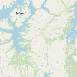
Seiland National Park landscape and geographic character

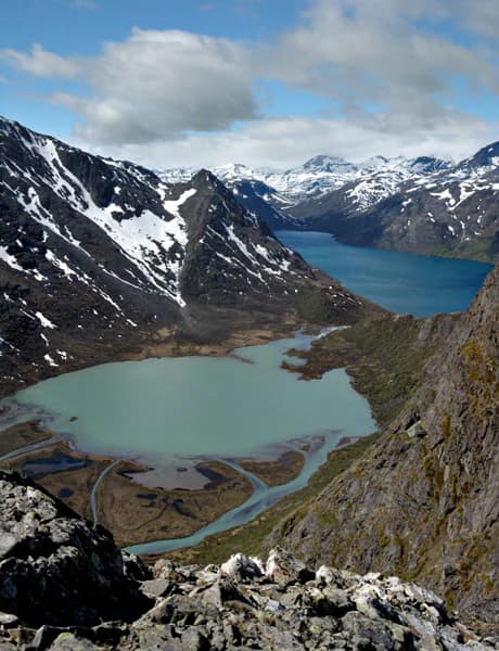
The landscape of Seiland National Park is defined by its Arctic island setting and mountain terrain. The island's central spine rises to Seilandstuva at 1,078 metres, with the terrain radiating outward toward the coast. Two glaciers, Seilandsjøkelen and Nordmannsjøkelen, occupy valley systems in the higher elevations—these are the northernmost glaciers in Scandinavia and represent significant glacial heritage in a region where glacial retreat is a noted concern. The coastline is deeply carved by fjords including Nordefjorden, Sørefjorden, and Flaskefjorden, which create complex shoreline geometry and include marine waters within the park. Above the shoreline, the terrain transitions through coastal meadow zones into heather-covered slopes before reaching the alpine zone. The combination of glaciated mountains, coastal fjords, and open heath creates a dramatic Arctic landscape with strong visual contrast between water, low vegetation, and bare rock.

Seiland National Park ecosystems, habitats, and plant life

The nature of Seiland National Park encompasses a diverse range of Arctic and sub-Arctic habitats. Along the fjord inlets, narrow belts of coastal meadow and semi-natural grassland persist where historic mowing and grazing have maintained species-rich turf. Botanists have documented vulnerable plant species including the Finnmark snow-primrose (Primula farinosa) in these coastal meadow areas. Of particular conservation significance are the traditional hay meadows known as slåttemark, classified as critically endangered habitats that survive on slopes north of Store Bekkarfjord. These represent remnants of 20th-century pastoral practice. Inland areas support semi-natural mires and wet meadows characterized by bottle sedge, cloudberry, and sundew species. The upland areas above the tree line are dominated by boreal heath with crowberry and reindeer lichen, transitioning to tundra on exposed ridges where low forbs, mosses, and lichens form continuous alpine plant communities.

Seiland National Park wildlife and species highlights

The wildlife of Seiland National Park has been documented through systematic surveys including helicopter-based bird surveys conducted in 2019. These surveys recorded 122 bird observations across 27 species, documenting breeding populations of raptors and waders. Five golden eagle territories were confirmed within the park, with two pairs successfully fledging young in 2019. Nine white-tailed eagle territories were recorded, with at least one successful brood documented. The bird fauna includes red-listed species such as the Eurasian curlew and black-tailed godwit, both of conservation concern in Norway. Vulnerable falcon species including gyrfalcon and peregrine falcon are also present. Ptarmigan species are noted as locally important. Mammalian records include the Eurasian otter, which is classified as vulnerable in Norway, and evidence of Arctic hare presence. The distribution of these records emphasizes the importance of both coastal cliffs and inland ridges as breeding and foraging areas.

Seiland National Park conservation status and protection priorities

Seiland National Park represents important conservation infrastructure for northern Norway. The park protects habitat types that are rare at this latitude, including the critically endangered slåttemark (traditional hay meadows) which require ongoing management to maintain their ecological character. The park's coastal meadows support vulnerable plant species including the Finnmark snow-primrose and other red-listed taxa. The bird survey data demonstrates significant breeding populations of raptor species including golden eagles and white-tailed eagles, both of which are species of conservation interest in Norway. The presence of vulnerable species such as the Eurasian otter further emphasizes the conservation value of the protected area. The inclusion of marine waters within the park boundary reflects recognition that coastal and marine ecosystems are interconnected with terrestrial systems, particularly in Arctic island environments.

Seiland National Park cultural meaning and human context

The cultural context of Seiland National Park is reflected in the park's dual official names in Norwegian and Northern Sami languages. The Northern Sami name Sievjju álbmotmeahcci acknowledges the traditional land use of the Sami people in this region. The presence of traditional hay meadows (slåttemark) within the park represents cultural landscapes shaped by centuries of pastoral practice including mowing and grazing. These semi-natural grasslands exist where historic agricultural practices maintained species-rich turf, and remnants of 20th-century mowing remain visible in both field observations and aerial imagery. The park lies between the municipalities of Alta and Hammerfest, two urban centres that serve as administrative and service hubs for the surrounding region. This Arctic island landscape has been shaped by both natural processes and human activity, with the cultural dimension reflected in place names and traditional land use patterns.

Top sights and standout views in Seiland National Park

Seiland National Park's defining characteristics include its status as a relatively new protected area established in 2006, its island setting in Norway's northernmost county, and the presence of Scandinavia's northernmost glaciers. The park protects critical habitat types including the critically endangered slåttemark hay meadows and coastal meadows supporting rare plant species. The raptor population is particularly significant, with confirmed breeding territories for both golden eagles and white-tailed eagles. The landscape combines dramatic mountain terrain, glaciers, deep fjords, and Arctic heath in a compact island setting. The dual naming in Norwegian and Northern Sami reflects the region's cultural heritage and the significance of the landscape to indigenous communities.

Best time to visit Seiland National Park

Seiland National Park experiences Arctic conditions typical of northern Norway, with visit timing influenced by the harsh climate. Summer months offer the most accessible conditions for exploration, with longer daylight hours and relatively milder temperatures compared to winter. The park's island setting means that weather conditions can change rapidly, and visitors should be prepared for variable conditions regardless of season. The best wildlife viewing opportunities occur during the breeding season when bird surveys have documented the highest species activity, particularly in June and July when systematic surveys have been conducted. Winter conditions on the island are severe and would present significant challenges for independent visitors.

Park location guide

Geography guide, regional context, and park location map for Seiland National Park

Seiland National Park park geography, regions, and map view in Norway
Understand where Seiland National Park sits in Norway through a broader geographic reading of the surrounding landscape, nearby location context, and its mapped position within the national park landscape.

How Seiland National Park fits into Norway

Norway, officially the Kingdom of Norway, is a Nordic country in Northern Europe located on the Scandinavian Peninsula. It encompasses mainland Norway, the Arctic islands of Svalbard and Jan Mayen, and maintains dependencies including Bouvet Island and Antarctic claims. The country has a population of about 5.6 million and is bordered by Sweden, Finland, and Russia. Norway is a unitary parliamentary constitutional monarchy with Oslo as its capital and largest city.

Wider geography shaping Seiland National Park in Norway

Norway occupies the western and northern portions of the Scandinavian Peninsula in Northern Europe. The country shares a long eastern border with Sweden, and borders Finland and Russia to the northeast. Norway has an extensive coastline facing the Skagerrak, North Sea, Norwegian Sea, and Barents Sea. The terrain is predominantly mountainous with numerous fjords along the coastline.

Map view of Seiland National Park

Use this park location map to pinpoint Seiland National Park in Norway, understand its exact geographic position, and read its mapped placement within the surrounding landscape more clearly.

Pigeon | © OpenStreetMap contributors

Location context for Seiland National Park

Alta MunicipalityFinnmarkHammerfest Municipality

Explore the Unique Arctic Island Terrain, Coastal Fjords, and Glacial Habitats of Seiland National Park Through Detailed Imagery

Seiland National Park Photos, Landscape, and Arctic Scenery: Visual Guide to Norway's Glaciers
Visually explore Seiland National Park's dramatic Arctic island environment, examining its unique combination of glaciated mountains, deep coastal fjords, and alpine habitats. These images provide essential context for understanding the park's protected landscapes and its significance as home to Scandinavia's northernmost glaciers and rare ecosystems.

Snow-dusted mountains surrounding a turquoise lake with winding river channels, viewed from a rocky hillside

Park atlas

Explore the geographic context of surrounding protected areas, from coastal fjords to alpine terrains, across Norway's Finnmark region.

Discover Other National Parks and Protected Areas Near Seiland National Park in Arctic Norway
Browse a curated list of national parks and other protected areas situated near Seiland National Park, encompassing Norway's unique Arctic island ecosystems and glacial landscapes. Compare diverse regional protected landscapes and trace the geographic spread of conservation efforts across northern Scandinavia, from glaciated mountains to coastal zones.
National park

Stabbursdalen National Park: Protected Arctic Landscape and Northernmost Pine Forest Atlas

Explore Finnmark's unique geography and protected terrain.

Stabbursdalen National Park preserves a remarkable ecological boundary, featuring the planet's northernmost Scots pine woodland within a dramatic Arctic landscape. This protected area offers a deep dive into rugged mountain terrain, river valley formations, and vital wetland habitats. As a key component of Norway's protected lands, it provides essential context for understanding regional geography and the limits of forest ecosystems on the mapped landscape.

Area
747 km²
Established
1970
IUCN
II
Relief
Mixed relief
National parkTroms

Reisa National Park: Dramatic River Valley and Protected Landscape Atlas

Subarctic terrain and geographic context in Troms, Norway.

MoriAtlas offers detailed geographic context for Reisa National Park, a protected landscape in Norway's Troms county. Explore the park's identity as a significant subarctic river valley, carved by the Reisa River into a dramatic canyon system. This page provides insights into its mapped natural features, regional landscape setting, and its importance within the broader atlas of protected areas. Understand the park's protected boundaries and terrain for structured geographic discovery.

Area
803 km²
Established
1986
IUCN
II
Relief
Mixed relief
National parkKarasjok Municipality

Anárjohka National Park: Mapped Subarctic Wilderness and Protected Landscape

Explore Norway's Finnmarksvidda plateau geography.

Anárjohka National Park, a protected area in Norway's Finnmark region, offers a compelling atlas-level view of subarctic wilderness. The park's landscape is defined by its location on the Finnmarksvidda plateau, featuring rolling birch woodlands, open pine barrens, and extensive wetlands, all mapped within its protected boundaries. This park provides a crucial point of discovery for understanding regional geography, natural terrain, and the interconnectedness of protected lands across northern Europe.

Area
1,409 km²
Established
1976
IUCN
II
Relief
Mixed relief
National parkFinland

Lemmenjoki National Park: Finland's Protected Landscape Geography

Explore mapped park boundaries and regional natural context.

Lemmenjoki National Park is a vital protected area situated within Finland's vast northern geography. This page details its designation as a national park, offering a clear view of its mapped boundaries and landscape character. Users can explore the park's geographic context within Finland and understand its contribution to the region's network of conservation lands, facilitating structured atlas-style discovery.

Area
2,850 km²
Established
1956
IUCN
Ib
Visitors
21.1K annual
National parkTroms

Øvre Dividal National Park: Arctic Alpine Protected Landscape in Troms, Norway

Mapped boundaries and unique ecological terrain of a pristine wilderness.

Øvre Dividal National Park stands as a premier example of Arctic alpine wilderness, meticulously preserved as a national park in Norway's Troms region. This entry facilitates a detailed exploration of its mapped protected boundaries and the distinct elevational ecological zones, from boreal forests to high-altitude tundra. Gain geographic context for this vital landscape, which supports diverse habitats and contributes to Scandinavia's largest contiguous wilderness areas.

Area
750 km²
Established
1971
IUCN
II
Relief
Mountain
National parkFinnmark

Varangerhalvøya National Park: Explore Finnmark's Unique Subarctic Protected Landscape

Mapped tundra, wetlands, and Arctic fox conservation.

Varangerhalvøya National Park offers a compelling atlas exploration of Norway's northeasternmost protected landscapes. This national park in Finnmark is distinguished by its subarctic terrain, featuring expansive tundra, diverse wetlands, and a unique ecological position where multiple biomes converge. It is a critical habitat for the Arctic fox and a vital Important Bird Area, providing deep insights into protected area geography and landscape context for those studying regional conservation and natural formations.

Area
1,804.1 km²
Established
2006
IUCN
II
Relief
Lowland
Watercolor painting showing rolling hills, forests, and distant mountains under a soft sky
National parkLapland

Pallas-Yllästunturi National Park: Lapland's Premier Protected Fell Landscape for Atlas Exploration

Explore its ancient mountain geography and mapped protected area.

Pallas-Yllästunturi National Park presents a unique atlas of Lapland's ancient geography, characterized by a vast chain of rounded fells that are the remnants of three-billion-year-old mountains. As Finland's most popular national park, it offers a deep dive into protected landscape discovery, showcasing diverse boreal forests, mires, and exceptional fell terrain. Understand its geographic scope and protected boundaries for comprehensive map-based exploration.

Area
1,020 km²
Established
2005
IUCN
II
Visitors
598.8K annual
National park

Øvre Pasvik National Park: Norway's Pristine Siberian Taiga & Mapped Boreal Geography

Explore ancient forests, wetlands, and transboundary protected landscapes.

Øvre Pasvik National Park is a landmark protected area in Northern Norway, showcasing a remarkably intact Siberian taiga ecosystem characterized by ancient Scots pine forests and extensive wetlands. This national park offers a unique geographic perspective with its notably flat terrain, distinguishing it within the broader Norwegian atlas. As part of the Pasvik, Inari Trilateral Park, it highlights significant transboundary conservation efforts and provides a valuable mapped resource for understanding European boreal landscapes and their unique wildlife habitats.

Area
119 km²
Established
1970
IUCN
II
Relief
Lowland

Common questions about visiting, size, designation, and location context for Seiland National Park

Seiland National Park FAQs for park facts, access, geography, and protected area context
Find quick answers about Seiland National Park, including protected-area facts, park geography, trail and visitor context, and how the park fits into its surrounding country and regional landscape.
MoriAtlas Explorer

Continue Your Protected Areas Search Across the Global Atlas

Deepen your exploration by continuing the structured search for national parks and protected areas worldwide. Utilize the comprehensive filtering capabilities to compare different conservation landscapes and refine your understanding of global park geography. Discover more about the distribution and characteristics of protected natural areas.

Global natural geography