Mori Atlas logo
National parkSør-Spitsbergen National Park

Mapping glacial terrain, seabird colonies, and tundra ecosystems across Svalbard's southern wilderness.

Sør-Spitsbergen National Park: Norway's Arctic Protected Landscape Atlas

(Sør-Spitsbergen nasjonalpark)

Sør-Spitsbergen National Park represents a significant portion of southern Spitsbergen, Norway, recognized as a protected national park since 1973. This vast area, covering approximately 8,500 square kilometers, is characterized by dramatic Arctic landscapes, featuring extensive ice caps, glacial valleys, and sparse tundra vegetation. As a key component of the Svalbard archipelago's geography, the park offers profound insights into one of Europe's most pristine Arctic environments, supporting critical wildlife habitats, including globally significant seabird colonies.

Arctic wildernessNational parkSeabird coloniesIce cap landscapeTundra ecosystemsProtected area

Sør-Spitsbergen National Park

National park

Park overview

Structured park overview, official facts, and landscape profile for Sør-Spitsbergen National Park

Sør-Spitsbergen National Park park facts, protected area profile, and essential visitor context
Review the core facts for Sør-Spitsbergen National Park, including designation, size, terrain, visitor scale, habitats, and operating context in one park-focused overview.

About Sør-Spitsbergen National Park

Sør-Spitsbergen National Park protects the southern end of Spitsbergen, the main island of the Svalbard archipelago situated roughly midway between mainland Norway and the North Pole. The park encompasses three major land areas: Wedel Jarlsberg Land, Torell Land, and Sørkapp Land, together forming a landscape of extraordinary Arctic grandeur. Glaciers dominate the terrain, with ice caps covering more than 65 percent of the total area, while the remaining ice-free terrain consists of tundra valleys, coastal plains, and rugged headlands.

The establishment of the park in 1973 reflected Norway's recognition that this remote Arctic region warranted formal protection as a national park. The area had already served as an important wildlife sanctuary through earlier designations of bird protection zones. Today the park operates under the management authority of the Norwegian Directorate for Nature Management, which oversees conservation activities, research programs, and visitor management in this challenging environment.

What distinguishes Sør-Spitsbergen from other Arctic protected areas is the combination of its scale, its relatively pristine condition, and the global significance of its bird populations. The park provides habitat for species that rely on coastal cliff sites and island territories for breeding, making it essential for maintaining healthy populations of seabirds that migrate throughout the North Atlantic. The protection framework extends beyond the land to include marine areas, recognizing that the coastal and ocean environments are integral to the ecosystem's function.

Quick facts and research context for Sør-Spitsbergen National Park

Sør-Spitsbergen National Park covers 8,504 square kilometers in the southern portion of Spitsbergen island, making it one of the largest protected areas in the Norwegian Arctic. The park was established in 1973 and is managed by the Norwegian Directorate for Nature Management under IUCN Category II protection. Over 65 percent of the park consists of ice cap, with the remaining terrain supporting tundra vegetation across valleys and coastal zones. The park includes the Isøyane archipelago, designated as a Ramsar Wetland of International Importance in 1985. The coastal bird sanctuaries support globally significant breeding populations, particularly thick-billed guillemots which number over 200,000 pairs within the park boundaries.

Park context

Deeper park guide and search-rich context for Sør-Spitsbergen National Park

Sør-Spitsbergen National Park history, landscape, wildlife, and travel context
Explore Sør-Spitsbergen National Park through its history, landscape character, ecosystems, wildlife, conservation priorities, cultural context, and seasonal travel timing in a structured park guide built for atlas discovery and search intent.

Why Sør-Spitsbergen National Park stands out

Sør-Spitsbergen is best known for its extraordinary seabird colonies nesting on the coastal islands and cliffs. The park hosts one of the world's largest breeding concentrations of thick-billed guillemots, with over 200,000 pairs occupying the rocky seabird colonies. The Isøyane bird sanctuary, recognized under the Ramsar Convention, protects a cluster of islands with grassy vegetation, freshwater ponds, and bare rock ideal for nesting barnacle geese, common eiders, and black-legged kittiwakes. The dramatic contrast between extensive ice caps and ice-free tundra valleys defines the park's visual character, while the relative absence of human activity has allowed natural processes to continue largely uninterrupted.

Panoramic mountain landscape featuring a turquoise lake, snow-covered peaks, rocky slopes, and a river flowing into the lake
Panoramic view of a mountainous valley with turquoise lake, snow-capped peaks, and rocky terrain

Sør-Spitsbergen National Park history and protected-area timeline

Sør-Spitsbergen National Park was established in 1973, representing one of Norway's earlier designations of Arctic wilderness areas as national parks. The creation of the park built upon earlier conservation measures that had recognized the international significance of Svalbard's wildlife, particularly the seabird colonies that had drawn attention from ornithologists and naturalists since the early twentieth century.

Prior to national park designation, portions of the area had been protected as bird sanctuaries, reflecting the extraordinary concentrations of breeding seabirds found along the coast and on the offshore islands. The Isøyane archipelago, with its cluster of grassy islands and freshwater ponds, had long been recognized as a particularly important breeding site and received early protection as a bird sanctuary.

In 1985, the international importance of the Isøyane wetlands was further recognized through designation as a Ramsar Wetland of International Importance, bringing the site under the global framework for wetland conservation. This Ramsar designation acknowledged both the ecological significance of the freshwater and coastal wetland habitats and the critical role they play in supporting breeding bird populations.

Sør-Spitsbergen National Park landscape and geographic character

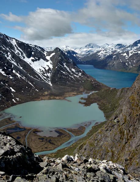
The landscape of Sør-Spitsbergen National Park exemplifies the dramatic contrasts of high Arctic terrain. Massive ice caps dominate the interior, their white and blue surfaces extending across mountain ridges and valleys in vast sheets of frozen water. These glaciers, some of which reach sea level, have carved deep valleys and sculpted the surrounding mountains into sharp-edged peaks and dramatic ridges.

Between the glacial areas, ice-free valleys and coastal plains support tundra vegetation, though the plant cover remains sparse due to the extreme climate. The terrain transitions from the glaciers to coastal zones characterized by rocky shores, beach ridges, and cliff faces that provide nesting habitat for seabirds. The offshore islands of the Isøyane archipelago offer a different character, with their grassy slopes and sheltered ponds providing visual variety from the more austere mainland terrain.

The coastline alternates between steep cliffs where seabirds nest in spectacular colonies and more gently sloping beaches where meltwater streams create freshwater pockets amid the brackish coastal environment. Overall, the landscape conveys a sense of raw, elemental Arctic wilderness where natural processes dominate and human presence remains minimal.

Sør-Spitsbergen National Park ecosystems, habitats, and plant life

The nature of Sør-Spitsbergen reflects the harsh but ecologically productive conditions of the Arctic tundra and coastal marine environment. Despite the extreme latitude and cold climate, the park supports a surprising diversity of habitats that together sustain significant wildlife populations. The tundra vegetation, while not lush, includes mosses, lichens, and low-growing vascular plants that form the base of the terrestrial food web.

The coastal islands and cliff sites represent the most ecologically significant habitats within the park, providing the conditions necessary for large seabird colonies to thrive. The grassy vegetation on islands like those in the Isøyane group supports breeding barnacle geese, while the cliff ledges and rocky surfaces accommodate massive colonies of thick-billed guillemots, black-legged kittiwakes, and common eiders. Freshwater ponds scattered across the tundra and island areas provide additional habitat diversity and feeding grounds for waterfowl.

The marine environment surrounding the coastal areas is integral to the park's ecology, as the seabirds depend on productive waters for their food supply. The intersection of cold Arctic currents creates conditions that support abundant fish populations and invertebrate prey species that sustain the breeding bird populations.

Sør-Spitsbergen National Park wildlife and species highlights

The wildlife of Sør-Spitsbergen National Park is defined by its remarkable seabird colonies, which represent some of the most significant breeding concentrations in the Arctic. Thick-billed guillemots form the most spectacular component, with over 200,000 pairs nesting in dense colonies on cliff faces and coastal rocks. These black and white diving birds nest in such density that the cliff surfaces appear black with their numbers.

Black-legged kittiwakes, named for their distinctive call, breed in substantial numbers with approximately 25,900 pairs recorded within the park. Their graceful flight and white markings make them a visible presence along the coastlines. Common eiders, the large sea ducks that winter in Arctic waters, nest in sheltered locations with about 1,000 pairs using the park's islands and coastlines.

Barnacle geese, which migrate from wintering grounds in western Europe to breed in the high Arctic, find ideal habitat in the grassy island environments of Isøyane, with 850 to 950 pairs breeding annually. Beyond these key species, the park supports additional birdlife including various seabirds, shorebirds, and occasional encounters with Arctic foxes that hunt along the coastline. The surrounding waters host marine mammals including seals and walruses that occasionally appear along the coast.

Sør-Spitsbergen National Park conservation status and protection priorities

Sør-Spitsbergen National Park represents a significant commitment to Arctic ecosystem preservation at a time when climate change and increasing human activity pose growing challenges to northern environments. The park's designation as an Important Bird Area by BirdLife International reflects the global responsibility Norway has accepted in protecting these seabird breeding populations. The Ramsar designation of Isøyane as a wetland of international importance further demonstrates the site's significance within international conservation frameworks.

The protection framework addresses both the terrestrial and marine components of the ecosystem, recognizing that the health of the bird populations depends on both the nesting habitat and the surrounding marine environment where they feed. Management by the Norwegian Directorate for Nature Management ensures that conservation priorities guide any permitted activities within the park boundaries. The extreme remoteness and harsh conditions of the park provide some natural protection, but active conservation measures remain important for maintaining the ecological integrity of this Arctic wilderness area.

Sør-Spitsbergen National Park cultural meaning and human context

The cultural context of Sør-Spitsbergen National Park is limited compared to more southerly protected areas, as the extreme Arctic conditions have never supported permanent human settlement. The Svalbard archipelago has a history of seasonal hunting and fishing activity by Norwegian and other northern European peoples, but the harsh climate and limited resources made sustained habitation difficult.

Today, the park remains essentially wilderness, with no permanent human population and minimal infrastructure. Any historical relationship between human communities and this particular landscape was transient and seasonal rather than establishing deep cultural ties to the land. The modern context is primarily one of scientific research and conservation management, with occasional visitors engaged in guided wilderness exploration of this remote Arctic environment.

Top sights and standout views in Sør-Spitsbergen National Park

The extraordinary density of seabird breeding colonies makes Sør-Spitsbergen one of the most significant bird habitats in the Arctic. Over 200,000 pairs of thick-billed guillemots nest within the park, creating one of the world's largest colonies of this species. The Isøyane archipelago offers a more accessible introduction to the park's wildlife, with its grassy islands and freshwater ponds supporting barnacle geese, common eiders, and black-legged kittiwakes in spectacular settings. The contrast between massive ice caps and ice-free tundra valleys creates visually striking landscapes that convey the essence of Arctic wilderness. The Ramsar-protected wetlands at Isøyane represent international recognition of the park's ecological importance and provide specific focus for conservation attention.

Best time to visit Sør-Spitsbergen National Park

The brief Arctic summer from approximately mid-June to late August offers the most accessible window for visiting Sør-Spitsbergen National Park. During this period, temperatures remain above freezing, though rarely warm by temperate standards, and the midnight sun provides continuous daylight for exploration. Wildlife viewing peaks during this season as seabirds nest and rear their young, with the bird colonies at their most active and visible.

The winter months present dramatically different conditions, with extended polar night, extreme cold, and limited accessibility that make the park essentially a wilderness for specialized expeditions rather than general visitation. Those who experience the Arctic winter find a stark beauty in the ice-covered landscape, but the practical challenges of extreme cold, limited daylight, and the need for specialized equipment make this a destination for experienced Arctic travelers only. The shoulder seasons of spring and autumn offer transitional conditions but with less predictable accessibility and wildlife activity.

Park location guide

Geography guide, regional context, and park location map for Sør-Spitsbergen National Park

Sør-Spitsbergen National Park park geography, regions, and map view in Norway
Understand where Sør-Spitsbergen National Park sits in Norway through a broader geographic reading of the surrounding landscape, nearby location context, and its mapped position within the national park landscape.

How Sør-Spitsbergen National Park fits into Norway

Norway, officially the Kingdom of Norway, is a Nordic country in Northern Europe located on the Scandinavian Peninsula. It encompasses mainland Norway, the Arctic islands of Svalbard and Jan Mayen, and maintains dependencies including Bouvet Island and Antarctic claims. The country has a population of about 5.6 million and is bordered by Sweden, Finland, and Russia. Norway is a unitary parliamentary constitutional monarchy with Oslo as its capital and largest city.

Wider geography shaping Sør-Spitsbergen National Park in Norway

Norway occupies the western and northern portions of the Scandinavian Peninsula in Northern Europe. The country shares a long eastern border with Sweden, and borders Finland and Russia to the northeast. Norway has an extensive coastline facing the Skagerrak, North Sea, Norwegian Sea, and Barents Sea. The terrain is predominantly mountainous with numerous fjords along the coastline.

Map view of Sør-Spitsbergen National Park

Use this park location map to pinpoint Sør-Spitsbergen National Park in Norway, understand its exact geographic position, and read its mapped placement within the surrounding landscape more clearly.

Pigeon | © OpenStreetMap contributors

Location context for Sør-Spitsbergen National Park

SpitsbergenSvalbard

Visualize the Dramatic Glacial Terrain, Tundra Valleys, and Seabird Habitats of this Remote Arctic Protected Area

Sør-Spitsbergen National Park Photos: Explore Arctic Wilderness Landscapes and Iconic Scenery
Browse a curated collection of Sør-Spitsbergen National Park images to understand its striking Arctic landscapes, dominated by vast ice caps, sculpted mountains, and remote tundra valleys. This visual atlas helps users grasp the park's unique protected-area character, including its critical seabird habitats on coastal cliffs and isolated islands.

Panoramic mountain landscape featuring a turquoise lake, snow-covered peaks, rocky slopes, and a river flowing into the lake

Park atlas

Trace the mapped geography of surrounding Arctic protected landscapes for comparative park exploration.

Discover Nearby National Parks and Protected Areas Around Sør-Spitsbergen National Park
After exploring Sør-Spitsbergen National Park, delve into a curated list of other national parks and protected areas across the Norwegian Arctic. Compare their unique ice cap landscapes, tundra ecosystems, and crucial seabird habitats to broaden your understanding of this remote polar environment.
National parkSvalbard

Sassen, Bünsow Land National Park: A Mapped Arctic Glacial Landscape in Svalbard

Explore protected boundaries and polar terrain.

Sassen, Bünsow Land National Park, located in the heart of Spitsbergen, Norway, showcases a quintessential Arctic wilderness defined by its expansive glacial features and deeply incised valleys. This protected area, part of the Svalbard archipelago, offers rich geographic context through its mapped terrain, highlighting glacial processes that have shaped the landscape. Discover the unique polar environment and the significance of this national park within the broader Norwegian Arctic atlas.

Area
1,230 km²
Established
2003
IUCN
II
Relief
Mountain
Watercolor illustration of a fjord with mountains, trees, and water bodies
National parkSpitsbergen

Nordre Isfjorden National Park: Arctic Coastal Protected Landscape

Discover Spitsbergen's mapped fjord geography and wildlife.

Nordre Isfjorden National Park on Spitsbergen offers a compelling view into a pristine Arctic environment. This protected national park encompasses dramatic coastal cliffs, tundra terrain, and the biologically rich waters of Isfjorden. It is renowned for supporting immense seabird colonies that rely on the nutrient-dense fjord, making it a significant site for understanding high Arctic ecosystems and marine protected areas.

Area
2,954 km²
Established
2003
IUCN
II
Relief
Lowland
National parkSvalbard

Forlandet National Park: High Arctic Protected Landscape and Global Wildlife Limits

Explore mapped geography and protected ecosystem boundaries in Svalbard.

Forlandet National Park stands as a crucial element in the Arctic atlas, safeguarding the island of Prins Karls Forland and its surrounding marine territories. As the world's most northerly national park, it showcases a unique High Arctic landscape defined by stark coastal cliffs and vital waters supporting specialized wildlife. This protected area is recognized for harboring the most extreme northern populations of seals and common guillemots, making it a significant site for understanding polar ecosystems and conservation efforts within the Svalbard region.

Area
4,647 km²
Established
1973
IUCN
II
Relief
Lowland
National park

Indre Wijdefjorden National Park: Arctic Steppe and Fjord Protected Landscape Exploration

Mapped protected boundaries and unique terrain in Svalbard.

Discover the unique High Arctic steppe and dramatic fjord landscape of Indre Wijdefjorden National Park, a protected area in Svalbard, Norway. This park safeguards a rare ecosystem with endemic plant species, offering exceptional insights into Arctic geography and protected land conservation. Explore its mapped boundaries and distinct terrain, a key destination for atlas-based landscape discovery.

Area
1,127 km²
Established
2005
IUCN
II
Relief
Mountain
National parkSvalbard

Nordvest-Spitsbergen National Park: Protected Arctic Landscape and Geographic Atlas

Explore unique hot springs, glacial terrain, and polar expedition history.

Nordvest-Spitsbergen National Park, a protected national park in Norway's Svalbard archipelago, showcases dramatic Arctic geography. This page details its mapped landscapes, from volcanic terrains and glacial valleys to its famed northernmost hot springs. Discover the park's protected area status, its role in regional geography, and its historical significance for polar exploration, providing a rich context for atlas-based exploration.

Area
9,914 km²
Established
1973
IUCN
II
Relief
Mixed relief
National parkFinnmark

Seiland National Park: Arctic Island Landscape and Northernmost Scandinavian Glaciers

Mapped boundaries of protected terrain in Finnmark

Seiland National Park offers a distinct glimpse into Arctic island geography, renowned for protecting Scandinavia's northernmost glaciers. This protected area in Finnmark features a dramatic landscape shaped by glaciated mountains, deep coastal fjords, and alpine terrain, making it a key destination for understanding Nordic natural environments. MoriAtlas facilitates exploration of its mapped boundaries and the unique combination of glacial and marine ecosystems present.

Area
316 km²
Established
2006
IUCN
II
Relief
Mountain
National park

Stabbursdalen National Park: Protected Arctic Landscape and Northernmost Pine Forest Atlas

Explore Finnmark's unique geography and protected terrain.

Stabbursdalen National Park preserves a remarkable ecological boundary, featuring the planet's northernmost Scots pine woodland within a dramatic Arctic landscape. This protected area offers a deep dive into rugged mountain terrain, river valley formations, and vital wetland habitats. As a key component of Norway's protected lands, it provides essential context for understanding regional geography and the limits of forest ecosystems on the mapped landscape.

Area
747 km²
Established
1970
IUCN
II
Relief
Mixed relief
National parkFinnmark

Varangerhalvøya National Park: Explore Finnmark's Unique Subarctic Protected Landscape

Mapped tundra, wetlands, and Arctic fox conservation.

Varangerhalvøya National Park offers a compelling atlas exploration of Norway's northeasternmost protected landscapes. This national park in Finnmark is distinguished by its subarctic terrain, featuring expansive tundra, diverse wetlands, and a unique ecological position where multiple biomes converge. It is a critical habitat for the Arctic fox and a vital Important Bird Area, providing deep insights into protected area geography and landscape context for those studying regional conservation and natural formations.

Area
1,804.1 km²
Established
2006
IUCN
II
Relief
Lowland

Common questions about visiting, size, designation, and location context for Sør-Spitsbergen National Park

Sør-Spitsbergen National Park FAQs for park facts, access, geography, and protected area context
Find quick answers about Sør-Spitsbergen National Park, including protected-area facts, park geography, trail and visitor context, and how the park fits into its surrounding country and regional landscape.
MoriAtlas Explorer

Continue Your Protected Areas Search Across the Global Atlas

Deepen your exploration by continuing the structured search for national parks and protected areas worldwide. Utilize the comprehensive filtering capabilities to compare different conservation landscapes and refine your understanding of global park geography. Discover more about the distribution and characteristics of protected natural areas.

Global natural geography