

Mori Atlas logo
National parkNuristan National Park

Discover the mapped geography and natural terrain of this significant protected area.

Nuristan National Park: Afghanistan's Protected National Park Landscape

Nuristan National Park represents a key protected landscape within Afghanistan, offering a distinct geographic identity within the country's predominantly mountainous terrain. This national park serves as a focal point for understanding the distribution and mapped boundaries of conservation areas in Central and South Asia. Explore its natural terrain to grasp its regional context and significance in the atlas of protected lands.

National ParkMountain LandscapeSnow Leopard HabitatWildlife ConservationEastern AfghanistanHindu Kush

Nuristan National Park

National park

Park overview

Structured park overview, official facts, and landscape profile for Nuristan National Park

Nuristan National Park park facts, protected area profile, and essential visitor context
Review the core facts for Nuristan National Park, including designation, size, terrain, visitor scale, habitats, and operating context in one park-focused overview.

About Nuristan National Park

Nuristan National Park represents Afghanistan's commitment to biodiversity conservation in one of the most ecologically significant but under-protected regions of Central Asia. The park encompasses the entirety of Nuristan Province, a mountainous territory that forms part of the Hindu Kush range along Afghanistan's eastern border with Pakistan. This region has long been recognized for its ecological importance, with initial proposals for protected area status dating back to 1981 when the area was still part of Laghman and Kunar Provinces. The establishment of Nuristan as a separate province in July 1988 eventually enabled the creation of this comprehensive protected area covering the entire provincial territory. The park is administered jointly by the Ministry of Agriculture, Livestock and Irrigation and local communities, reflecting the traditional relationship between the local population and the land. A detailed management plan and formal gazetting process are still underway, indicating that the park is in an early stage of institutional development.

Quick facts and research context for Nuristan National Park

Nuristan National Park covers 5,733 square kilometers of mountainous terrain in eastern Afghanistan, making it one of the largest protected areas in the country. The park was officially announced on 5 June 2020 and protects the entire Nuristan Province, which is bordered by Pakistan to the east and south. The region features dramatic alpine landscapes, deep river valleys, and extensive forest coverage in a region historically referred to as the "land of light" due to its snow-capped peaks. The park falls within IUCN Category II (national park) and represents a significant addition to Afghanistan's protected area network, though conservation challenges include historical forest loss and ongoing pressures from illegal logging.

Park context

Deeper park guide and search-rich context for Nuristan National Park

Nuristan National Park history, landscape, wildlife, and travel context
Explore Nuristan National Park through its history, landscape character, ecosystems, wildlife, conservation priorities, cultural context, and seasonal travel timing in a structured park guide built for atlas discovery and search intent.

Why Nuristan National Park stands out

Nuristan National Park is best known for its remarkable biodiversity in the eastern Hindu Kush, particularly its populations of snow leopard and leopard among the large predators. The park protects crucial habitat for the markhor, a wild goat species with impressive spiral horns, as well as the Himalayan black bear. The region also supports significant bird diversity, with the Pech and Waygal valleys designated as an Important Bird Area supporting at least fifty-three breeding species. The park preserves what remains of the historically extensive monsoon-influenced forests of eastern Afghanistan, representing one of the most ecologically significant areas in the country despite significant historical forest loss.

Nuristan National Park history and protected-area timeline

The establishment of Nuristan National Park stems from recognition of the region's ecological significance that began in the early 1980s. An initial proposal was drafted in 1981 calling for the creation of a protected area in what was then Laghman Province and Kunar Province, before Nuristan Province was carved out of these territories in July 1988. The original proposal highlighted the region's largely undisturbed monsoon-influenced forests and the remarkable assemblage of species it supported, including leopard, snow leopard, Himalayan black bear, and markhor, alongside the traditional way of life of local communities. Despite this early recognition, the region has faced significant environmental challenges. A 2003 United Nations Environment Programme report documented the loss of 52 percent of forest cover in Nuristan, Laghman, and Nangarhar Provinces between 1977 and 2002. The National Environmental Protection Agency subsequently warned of continuing illegal logging pressures. Despite these challenges, a 2008 Wildlife Conservation Society report confirmed the continuing presence of key species including Himalayan black bear, leopard cat, grey wolf, golden jackal, yellow-throated marten, and crested porcupine, with additional felid species reported by local interviewees.

Nuristan National Park landscape and geographic character

Nuristan National Park occupies a dramatic mountainous landscape within the Hindu Kush range, characterized by steep alpine terrain, deep river valleys, and extensive forest coverage. The province spans the easternmost mountainous region of Afghanistan, forming a natural corridor along the border with Pakistan. The name Nuristan derives from the Persian word for "light" or "illuminated," referring to the region's prominent snow-capped peaks that reflect sunlight across the landscape. The terrain includes the Pech River and Waygal River valleys, which carve through the mountains creating diverse microhabitats and ecological zones. The landscape transitions from lower-elevation forest zones through subalpine meadows to permanent snow and rock at higher elevations, creating a complex topographical environment that supports diverse ecological communities.

Nuristan National Park ecosystems, habitats, and plant life

The natural environment of Nuristan National Park is defined by its monsoon-influenced forests, which represent some of the most significant remaining forest coverage in eastern Afghanistan. The region supports a complex ecological mosaic ranging from dense forested slopes at lower elevations through subalpine shrubland to alpine meadows and rocky terrain at higher elevations. The Pech and Waygal valleys have been designated as an Important Bird Area, recognizing the area's significance for avifauna with at least fifty-three breeding bird species documented. The region historically contained extensive forest cover, though significant loss occurred between 1977 and 2002 according to UNEP analysis. The park protects what remains of these ecosystems within a formal protected area framework, though the conservation status remains challenging given ongoing pressures.

Nuristan National Park wildlife and species highlights

Nuristan National Park supports a remarkable assemblage of wildlife despite the significant habitat loss the region has experienced. The park provides crucial habitat for snow leopard and leopard among the large predators, representing one of the few areas in Afghanistan where both species are confirmed to persist. The Himalayan black bear inhabits the forest zones, while the markhor, a distinctive wild goat species known for its impressive spiral horns, occupies the rocky mountain slopes. Additional mammalian species confirmed through the 2008 Wildlife Conservation Society survey include leopard cat, grey wolf, golden jackal, yellow-throated marten, and Indian crested porcupine. Local interviews also reported the presence of additional felid species, suggesting the true mammal diversity may exceed documented records. The Important Bird Area designation reflects significant avian diversity with at least fifty-three breeding species, though specific notable species are not detailed in available sources.

Nuristan National Park conservation status and protection priorities

Nuristan National Park represents a significant conservation achievement for Afghanistan, establishing formal protection for one of the country's most ecologically important mountainous regions. The park's designation as IUCN Category II reflects its primary function as a national park protecting natural ecosystems and biodiversity. However, the conservation context is challenging given the documented history of forest loss, with 52 percent of forest cover lost between 1977 and 2002 across the broader region. Ongoing pressures from illegal logging continue to pose threats to the park's forest ecosystems. The joint governance arrangement with local communities reflects recognition that successful conservation in this region requires integration with traditional land use practices and local livelihoods. The absence of a finalized management plan and formal gazettement indicates that the conservation framework remains in development, making the long-term effectiveness of protection uncertain.

Nuristan National Park cultural meaning and human context

The cultural context of Nuristan is deeply intertwined with the region's mountainous landscape and traditional communities. The name Nuristan, meaning "land of light" in Persian, reflects the significance of the snow-capped peaks that dominate the regional landscape. Local communities have maintained traditional relationships with the land over generations, which is reflected in the joint governance arrangement between the Ministry of Agriculture and local communities for the national park. The historical proposal for the protected area specifically noted the importance of the traditional way of life of local communities alongside the ecological significance of the region. The province's relative isolation has helped preserve cultural traditions, though development pressures and environmental changes present challenges to both ecological and cultural heritage.

Top sights and standout views in Nuristan National Park

Nuristan National Park protects the eastern Hindu Kush mountains, one of Afghanistan's most ecologically significant regions with confirmed populations of snow leopard, leopard, Himalayan black bear, and markhor. The park encompasses the entire Nuristan Province, covering over 5,700 square kilometers of mountainous terrain along the Pakistan border. The Pech and Waygal valleys are designated as an Important Bird Area supporting at least fifty-three breeding bird species. As the third national park in Afghanistan, established in 2020, it represents a relatively new addition to the country's protected area network and addresses a significant gap in conservation coverage for eastern Afghanistan's mountain ecosystems.

Best time to visit Nuristan National Park

The optimal time to visit Nuristan National Park would be during the warmer months from late spring through early autumn, when weather conditions in the high-altitude mountain environment are more accessible for exploration. Summer months typically offer the most stable conditions for mountain travel, though the region's position along the monsoon-influenced zone means that summer precipitation can be significant. The dramatic winter landscape shown in available photographs illustrates the extreme seasonal variation in the region, with heavy snow transforming the terrain but also creating significant access challenges. Given the park's recent establishment and ongoing development of management infrastructure, visitors should expect limited visitor facilities and should plan for challenging logistical conditions regardless of season.
Park location guide

Geography guide, regional context, and park location map for Nuristan National Park

Nuristan National Park park geography, regions, and map view in Afghanistan
Understand where Nuristan National Park sits in Afghanistan through a broader geographic reading of the surrounding landscape, nearby location context, and its mapped position within the national park landscape.

How Nuristan National Park fits into Afghanistan

Afghanistan is a landlocked country located at the crossroads of Central and South Asia. It is bordered by six countries and features a predominantly mountainous terrain with plains in the north and southwest. The country has a population estimated between 35 and 50 million people and uses Afghani as its currency.

Wider geography shaping Nuristan National Park in Afghanistan

Afghanistan is located in Central and South Asia, landlocked at the crossroads of these regions. It is bordered by Pakistan to the east and south, Iran to the west, Turkmenistan to the northwest, Uzbekistan to the north, Tajikistan to the northeast, and China to the northeast and east. The terrain is predominantly mountainous, with plains in the north (Afghan Turkestan) and southwest (Sistan Basin), separated by the Hindu Kush mountain range.

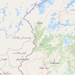
Map view of Nuristan National Park

Use this park location map to pinpoint Nuristan National Park in Afghanistan, understand its exact geographic position, and read its mapped placement within the surrounding landscape more clearly.

Pigeon | © OpenStreetMap contributors

Location context for Nuristan National Park

Nuristan Province
Park atlas

Compare other protected landscapes and national parks across the Hindu Kush mountain system, revealing the wider regional conservation geography.

Explore Other National Parks and Protected Areas Near Nuristan National Park in Eastern Afghanistan
After exploring Nuristan National Park, continue your journey into nearby national parks and other protected areas across the rugged Hindu Kush mountain system. Compare their unique biodiversity, alpine environments, and forest protection efforts to understand the broader conservation landscape of eastern Afghanistan.
National parkAfghanistan

Wakhan National Park: Afghanistan's Protected Landscape for Geographic Atlas Exploration

Mapped boundaries and regional terrain context.

Wakhan National Park is a designated national park in Afghanistan, offering critical insights into the country's rugged, mountainous geography. This page provides an atlas-level view of its protected landscape, detailing its geographic scope and mapped boundaries. Explore Wakhan National Park to understand its role within the broader regional context of Central and South Asia's natural terrain.

Area
10,910.1 km²
Established
2014
IUCN
II
Relief
Mountain
National parkIslamabad Capital Territory

Margalla Hills National Park: Pakistan's Gateway to Himalayan Foothills Geography

Mapped protected landscape with rich Sino-Himalayan biodiversity.

Margalla Hills National Park, situated in the Islamabad Capital Territory, serves as Pakistan's most accessible national park and a vital entry point to the Himalayan foothills. This protected landscape is defined by its rugged mountain terrain, ranging from lower scrublands to higher pine and oak woodlands, with elevations up to 1,604 meters. The park's geological significance, with ancient marine fossil formations, adds a unique dimension to its natural identity. Discover the mapped boundaries and ecological richness that characterize this important protected area, offering insights into regional geography and diverse habitats.

Area
173.86 km²
Established
1980
IUCN
V
Relief
Mountain
National parkKhyber Pakhtunkhwa

Ayubia National Park: Protected Area Identity and Mountainous Terrain

Discover its mapped geography within Khyber Pakhtunkhwa

Ayubia National Park stands as a key protected landscape within the Himalayan foothills of Khyber Pakhtunkhwa, Pakistan. Its designation as a national park signifies its role in conserving unique temperate coniferous and mixed forests across steep mountainous terrain. This page details the park's geographic setting, its mapped boundaries, and the natural features that define its protected status, offering a structured view for atlas-driven exploration of Pakistan's natural heritage.

Area
33.12 km²
Established
1984
IUCN
V
Visitors
250K annual
National parkPunjab

Kheri Murat National Park: Protected Scrub Forest and Wildlife Conservation in Punjab

Explore the mapped terrain and protected landscape context.

Discover Kheri Murat National Park, a recent national park designation located in Punjab, Pakistan, situated on the rolling hills of the Kala Chitta Range. This protected area features a distinct subtropical thorn scrub forest ecosystem, providing essential habitat for wildlife, including the Punjab urial, and serving as a critical site for bird conservation. Its unique landscape offers valuable insights into regional geography and the preservation of natural wilderness within a predominantly agricultural province, making it a noteworthy entity for atlas exploration.

Area
35.37 km²
Established
2020
IUCN
II
Relief
Mountain
National parkAzad Jammu and Kashmir

Machiara National Park: A Protected National Park in Pakistan's Himalayas

Explore mapped terrain and mountain biodiversity.

Machiara National Park, located in Azad Jammu and Kashmir, Pakistan, is a designated national park preserving unique Himalayan ecosystems. This atlas-focused exploration details the park's protected landscape, encompassing steep slopes, forested ridges, and varied terrain. Discover its significance for wildlife conservation and its position within the broader regional geography, offering a clear view of its mapped natural features.

Area
135.33 km²
Established
1996
IUCN
II
Relief
Mountain
National parkPunjab

Chinji National Park: National Park Atlas, Salt Range Geography, and Protected Landscape

Discover the unique eroded terrain and semi-arid ecosystems of Punjab, Pakistan.

Chinji National Park is a protected national park located in the Punjab province of Pakistan, specifically within the historic Salt Range. This park is characterized by its deeply eroded terrain, composed of sandstone and igneous rock formations, shaped by seasonal streams that lead towards the Soan River. As a key example of a semi-arid mountain ecosystem within the Baluchistan xeric woodlands ecoregion, Chinji National Park offers significant insights into the geological heritage and unique biodiversity of central Pakistan.

Area
60.95 km²
Established
1987
IUCN
II
Relief
Upland
National parkKhyber Pakhtunkhwa

Broghil Valley National Park: High-Altitude Protected Landscape and Alpine Wilderness in Pakistan

Explore mapped terrain with glacial lakes and diverse mountain ecosystems.

Broghil Valley National Park, a national park in Pakistan's Khyber Pakhtunkhwa province, is a vast high-altitude wilderness defined by its dramatic glacial topography, numerous freshwater lakes, and vital peatland ecosystems. Situated near the Afghanistan border, this protected area offers an exceptional landscape for exploring remote mountain biodiversity and understanding the geography of Pakistan's northern frontier. Its unique terrain provides critical habitat within the Central Asian mountain range.

Area
1,348 km²
Established
2010
IUCN
II
Relief
Mountain
National parkAzad Kashmir

Panjal Mastan National Park: High-Altitude Plateau Landscape in Azad Kashmir

Discover mapped terrain and protected area geography.

Panjal Mastan National Park represents a significant protected landscape within the Pir Panjal mountain range of Azad Kashmir, Pakistan. This national park is characterized by its expansive high-altitude plateau, sitting at an average elevation of 2,800 meters, offering a unique regional geography. Known for its dramatic mountainous surroundings and seasonal wildflower meadows that bloom in spring, the park provides valuable context for understanding the natural terrain and protected area distribution in this part of the western Himalayas.

Area
300 km²
IUCN
II
Relief
Mountain
Climate
Alpine

Common questions about visiting, size, designation, and location context for Nuristan National Park

Nuristan National Park FAQs for park facts, access, geography, and protected area context
Find quick answers about Nuristan National Park, including protected-area facts, park geography, trail and visitor context, and how the park fits into its surrounding country and regional landscape.
MoriAtlas Explorer

Continue Your Protected Areas Search Across the Global Atlas

Deepen your exploration by continuing the structured search for national parks and protected areas worldwide. Utilize the comprehensive filtering capabilities to compare different conservation landscapes and refine your understanding of global park geography. Discover more about the distribution and characteristics of protected natural areas.

Global natural geography
