Mori Atlas logo
Wildlife reserveOshana-System

Mapping the geographic channel network and expansive wetland corridors of the Cuvelai system

Oshana-System Wildlife Reserve: Exploring the Seasonal Floodplains of North-Central Namibia

The Oshana-System represents a vast, branching network of shallow drainage channels forming a critical seasonal wetland in north-central Namibia. Stretching from the Angolan border down to the Etosha Pan, this protected landscape is defined by the efundja flood cycle which transforms dry grassy pans into productive freshwater habitats. Understanding the geological and hydrological character of this region is essential for appreciating the scale of its temporary aquatic terrain and its role as a foundation for local environmental cycles.

wetlandseasonal floodplainRamsar sitebirdwatchingCuvelai BasinEtosha

Oshana-System

Wildlife reserve

Park overview

Structured park overview, official facts, and landscape profile for Oshana System

Oshana System park facts, protected area profile, and essential visitor context

Review the core facts for Oshana System, including designation, size, terrain, visitor scale, habitats, and operating context in one park-focused overview.

About Oshana System

The Oshana System is one of southern Africa's most distinctive inland wetland complexes, a slow-moving, fan-shaped network of channels, shallow pans, and grassy depressions that defines the geography of north-central Namibia. Rather than a single river, it functions as a distributed drainage network, with shallow watercourses flowing from the higher ground in southern Angola southward into the Etosha Pan. Because the system has very little gradient, water spreads laterally as much as it moves downstream, repeatedly flooding large areas during the wet season.

The Oshana Region and surrounding areas take their name from these channels. In the local Oshivambo language, the individual channels are called iishana, and the singular oshana has become the geographic term applied to the entire system. The broader basin, including the Etosha Pan, is also referred to as the Cuvelai Basin or Cuvelai-Etosha Basin, reflecting the regional name Cuvelai used for the upper catchment areas in Angola. The system today is recognised internationally as a significant wetland under the Ramsar Convention.

In ecological terms, the Oshana System is defined by seasonality. During the dry winter months, the channels appear as broad, flat-bottomed grassy corridors with little surface water and only sparse vegetation along their slightly elevated sandy edges, where mopane trees and makalani palms can establish. When the summer rains begin, runoff from the Angolan highlands arrives over a period of weeks, and water gradually fills the channels and adjacent depressions. In major flood years, the area becomes a continuous sheet of shallow water and emergent marshland, attracting large numbers of waterbirds and supporting temporary fish populations.

The system is not only a hydrological feature but also the cultural and economic heartland of the Ovambo people. Its seasonal pattern of flooding, pasture renewal, fishing, and cultivation has structured rural life in the region for centuries, and even today the rhythmic arrival of the efundja remains a defining event in the rural calendar. This blend of ecological function and cultural identity makes the Oshana System unlike almost any other wetland in southern Africa.

Quick facts and research context for Oshana System

The Oshana System is a Ramsar-listed wetland that covers more than 30,000 square kilometres at peak flood and drains roughly the northern shore of the Etosha Pan. Its channels originate on the Angolan Bié Plateau about 100 kilometres north of the Namibian border and converge into the Ekuma before reaching the pan.

The region's soils are dominated by nutrient-poor sandy Kalahari deposits with low water-retention capacity, making seasonal flooding essential for replenishing groundwater and supporting grass growth. Approximately 45 percent of Namibia's population lives in the broader Oshana and Etosha catchment area, relying on its seasonal water, fish, and grazing resources.

Protection and recognition

Documented terrestrial protection scope and international designation data

Oshana-System Protection Status and Transboundary Conservation Framework

Oshana-System maintains a documented terrestrial protection scope across shared borders as a transboundary conservation area. Structured facts detail the verified management boundaries and available international recognition records.

Protection details

Protection scope
Terrestrial
Transboundary protection
Yes
Park context

Deeper park guide and search-rich context for Oshana System

Oshana System history, landscape, wildlife, and travel context

Explore Oshana System through its history, landscape character, ecosystems, wildlife, conservation priorities, cultural context, and seasonal travel timing in a structured park guide built for atlas discovery and search intent.

Why Oshana System stands out

The Oshana System is best known for the dramatic seasonal flood pulse known as the efundja, when rains in southern Angola transform the channel network into a vast inland wetland. At its peak, more than 260 bird species have been recorded in the area, including about 90 exclusively wetland-dependent species such as flamingos, pelicans, and saddle-billed storks. It is equally renowned as the ecological and cultural foundation of the Ovambo homeland in north-central Namibia. The flood cycle supports freshwater fisheries, replenishes groundwater used by millions, and enables the subsistence agriculture that has shaped life in the region for generations.
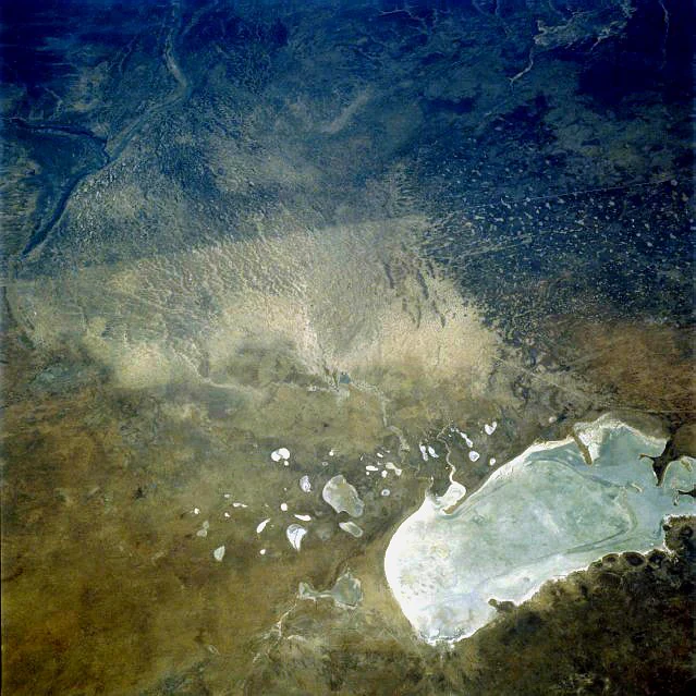
An aerial view showing a vast, bright white salt pan contrasted against dark, arid surrounding terrain with scattered smaller pools and drainage patterns.
Aerial view of the Etosha Pan, a defining feature of the Oshana system in Namibia.

Oshana System history and protected-area timeline

The history of the Oshana System is inseparable from the long-standing relationship between the Ovambo people and the seasonal flood cycle of north-central Namibia. For generations, communities adapted their agriculture, fishing, and livestock practices to the predictable rhythm of the efundja, building livelihoods around the wet-season abundance and the dry-season retreat of floodwaters into the Etosha Pan.

While awareness of the system's significance grew among colonial-era and later hydrological researchers, the twentieth century saw major changes. Twentieth-century reports described extensive dry forests across the region, but rapid population growth and expanded settlement led to widespread clearing for fuelwood, farmland, and grazing. The last major efundja before the late 2000s occurred in the 1950s, and in the decades that followed, settlements and livestock spread into channels and depressions that had previously flooded only occasionally.

A renewed series of major flood events between 2008 and 2011 revived the long-absent efundja cycle, but by then the landscape had been heavily settled, leading to significant losses of homes, livestock, and crops. These events drew renewed scientific and political attention to the system, including groundwater studies by institutions such as the German Federal Institute for Geosciences and Natural Resources, which identified substantial underground freshwater reserves beneath Ohangwena. The Oshana System was subsequently recognised under the Ramsar Convention, formalising its status as a wetland of international importance.

Oshana System landscape and geographic character

The landscape of the Oshana System is shaped by flatness, sand, and shallow channels. The region sits on nutrient-poor sandy Kalahari deposits that absorb water poorly, so instead of forming well-defined river valleys, runoff spreads into broad, shallow drainage corridors that gently slope from the Angolan highlands to the Etosha Pan.

In their dry state, the oshanas appear as wide, grassy troughs flanked by low sandy-clay levees. These slightly elevated margins support the most consistent vegetation in the landscape, primarily mopane woodland interspersed with makalani palms. The interior of the channels remains largely bare of woody vegetation, giving the system its characteristic open, savanna-like appearance during the dry months.

When water arrives, the same channels transform into elongated lakes and marshy flats. Floodwaters can remain for weeks or months, gradually evaporating as the dry season sets in, since impermeable subsoil layers prevent rapid infiltration. The scale of inundation, more than 30,000 square kilometres in major flood years, makes the system one of the most expansive temporary inland wetlands in southern Africa.

Oshana System ecosystems, habitats, and plant life

Ecologically, the Oshana System is defined by the alternation between dry grassy pans and seasonally inundated wetlands. This pulse between arid and aquatic conditions supports a distinctive mosaic of habitats, from mopane-dominated woodland on the channel margins to seasonal marshes, temporary open water, and brackish fringes near the Etosha Pan.

The wet-season phase brings a surge of biological activity. As channels fill, vegetation responds with rapid grass growth, and the flooded areas become nurseries for fish that move downstream from the Angolan catchments. Waterbirds arrive in large numbers to feed and breed in the temporary wetlands, taking advantage of the abundant aquatic productivity. Because of this strong seasonality, many of the system's ecological functions, including floodplain grazing, fish migration, and waterbird reproduction, are tightly linked to the timing and scale of each year's rains.

The dry phase is more austere but no less ecologically important. The bare, cracked clay and sand of the dry channels, the isolated mopane groves, and the scattered palms create a habitat mosaic that supports a range of drought-adapted species, while the persistent groundwater stored beneath the floodplains sustains vegetation, wildlife, and human communities through the long dry season.

Oshana System wildlife and species highlights

The Oshana System's wildlife profile is dominated by its seasonal birdlife. During major flood events, more than 260 bird species have been recorded in the area, of which around 90 are specifically dependent on wetland habitats. Among the most conspicuous are flamingos, which gather in large flocks on the shallower fringes, along with pelicans and the striking saddle-billed stork.

Beyond the waterbirds, the system supports a rich seasonal fishery. As floodwaters arrive, fish spread down the channels from upstream sources, and local people harvest them in large quantities using traditional methods such as hand capture and simple reed fish traps. These fish form an important seasonal food resource and are consumed fresh or dried for later use.

The surrounding mopane woodland and dry channels also host typical north-central Namibian fauna. The combination of woodland, grassland, and seasonal water creates edge habitats that support a range of mammals, reptiles, and invertebrates, while pulses of insect life, including mosquitoes, are characteristic of the wet season, making malaria a long-standing public-health concern across the region.

Oshana System conservation status and protection priorities

The Oshana System has formal international recognition as a Ramsar-listed wetland, a designation reflecting both its ecological significance and its importance as a seasonal refuge for waterbirds. The recognition underscores the value of the system not only for wildlife but also for the millions of people who depend on its seasonal hydrological cycle.

Conservation challenges are significant. The population living in the Oshana and Etosha catchment is large, around 45 percent of Namibia's total, and pressure on land and water is intense. Deforestation for fuelwood has largely eliminated the dry forests noted in older reports, and the expansion of settlements into channels that flood only intermittently has increased vulnerability to flood damage. Groundwater reserves, though substantial, are being drawn down faster than they recharge during dry periods.

At the same time, the system holds major untapped hydrological value. Investigations by the German Federal Institute for Geosciences and Natural Resources and Namibian partners have identified a deep aquifer in the Ohangwena area estimated to hold around 20 billion cubic metres of water, potentially capable of supplying the region for centuries if managed sustainably. Balancing conservation, rural livelihoods, and groundwater extraction remains a central challenge for the system's future.

Oshana System cultural meaning and human context

The Oshana System is the cultural heartland of the Ovambo people, the largest population group in Namibia. The name of the system, the channels themselves, the seasonal fish harvest, and the subsistence maize, millet, pumpkin, and bean fields all reflect a centuries-old adaptation to the rhythm of flooding and drying.

Traditional Ovambo fishing during the efundja, including hand capture and the use of reed fish traps, remains a defining cultural practice. The seasonal arrival of floodwater is more than a hydrological event; it shapes diet, agricultural calendars, livestock movements, and community life across the region. At the same time, the proximity of floodwaters and associated mosquito populations has historically shaped public health in the area, with malaria long endemic in the wetlands.

The combination of dense rural settlement, subsistence agriculture, livestock keeping, and seasonal fishing gives the Oshana System a strongly human character. Unlike many protected wetlands, it is a working landscape, where ecological processes and cultural practices are tightly interwoven.

Top sights and standout views in Oshana System

The Oshana System stands out for several defining qualities: it is one of the largest temporary inland wetland complexes in southern Africa, covering more than 30,000 square kilometres at peak flood, and it functions as a network rather than a single river, with shallow channels fanning out across a vast sandy plain.

Its seasonal flood pulse, the efundja, transforms dry grassy pans into a hub of birdlife, fish, and grass growth on which nearly half of Namibia's population indirectly depends. The system is internationally recognised under the Ramsar Convention, hosts a deep aquifer of strategic importance, and remains the cultural and ecological foundation of Ovambo society.

Best time to visit Oshana System

The character of the Oshana System is defined by the seasons. During the dry winter months, the channels appear as broad, flat-bottomed grassy corridors with little surface water, while mopane and makalani palms line their slightly elevated margins. This is the most accessible period for broader landscape viewing and for observing rural life in the Ovambo region.

The wet summer season, roughly from December into March, is when the system comes alive. Following heavy rains in Angola and northern Namibia, the efundja can transform the region into an extensive temporary wetland, attracting large numbers of waterbirds and renewing fisheries and pasture. Major floods, however, are unpredictable and have become a recurring challenge for local communities, having reappeared after a long absence between 2008 and 2011.

Monthly climate preview

Long-term representative measurements of monthly temperature and precipitation cycles

Oshana-System Climate Normals, Annual Temperature and Precipitation Rhythm

Representative coordinate records outline the annual temperature and precipitation rhythm across Oshana-System from long-term climatology data. Examining the complete monthly profile provides deeper baseline comparison values for regional temperature and rainfall patterns.
Annual mean24 °C
17 °C28 °C
Jan27°
Feb26°
Mar26°
Apr24°
May21°
Jun18°
Jul17°
Aug21°
Sep25°
Oct28°
Nov28°
Dec28°
Warmest month
November

28.2 °C

Coolest month
July

17.5 °C

Wettest month
February

3.5 mm/day

Driest month
June

0 mm/day

Park location guide

Geography guide, regional context, and park location map for Oshana System

Oshana System park geography, regions, and map view in Namibia

Understand where Oshana System sits in Namibia through a broader geographic reading of the surrounding landscape, nearby location context, and its mapped position within the national park landscape.

How Oshana System fits into Namibia

Namibia is a sovereign country in Southern Africa that gained independence from South Africa in 1990. It is the driest country in sub-Saharan Africa, characterized by the Namib Desert along its coast. The population is approximately 3 million, with Windhoek as the capital and largest city. Namibia operates as a unitary semi-presidential republic with a multi-party system.

Wider geography shaping Oshana System in Namibia

Namibia occupies 825,615 km2 in Southern Africa, making it the 34th largest country in the world. It is bordered by the Atlantic Ocean to the west, Angola and Zambia to the north, Botswana to the east, and South Africa to the south. The country features the Namib Desert along its coastal region, with varied terrain including savannas, mountains, and plateaus inland. A notable geographic feature is that Zimbabwe lies less than 200 metres away along the Zambezi river near Kazungula in the northeast.

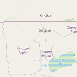
Map view of Oshana System

Use this park location map to pinpoint Oshana System in Namibia, understand its exact geographic position, and read its mapped placement within the surrounding landscape more clearly.

Pigeon | © OpenStreetMap contributors

Location context for Oshana System

Oshana Region

Visual exploration of seasonal floodplains, shallow drainage channels, and protected wetland habitats

Oshana-System Landscape and Scenery Photography

Photographic collections reveal the distinctive terrain and seasonal flood cycles that define the protected landscape of Oshana-System. Visual records capture the transformation of dry grassland pans into expansive inland wetlands, illustrating vital habitats across the region.

An aerial view showing a vast, bright white salt pan contrasted against dark, arid surrounding terrain with scattered smaller pools and drainage patterns.

A wide shot of a seasonal wetland landscape in Namibia, with shallow floodwaters covering the ground around scattered trees and patches of green marsh grass under a clear blue sky.

Park atlas

Compare adjacent wetland habitats, seasonal floodplains, and regional conservation zones.

Explore Protected Areas Near Oshana-System and Surrounding Regional Landscapes

Browse other national parks and protected areas near Oshana-System to evaluate regional ecological patterns and connected wetland geography. Comparing adjacent conservation landscapes provides deeper context on seasonal flood pulses and arid basin ecosystems across northern Namibia.
National parkKunene Region
About 55 km away#1 closest

South

Etosha National Park National Park: Mapped Protected Landscape and Regional Geography

Discover its protected boundaries and geographic context.

Gain a structured understanding of Etosha National Park, a prominent national park within Namibia's Kunene Region. This entry focuses on the park's protected landscape identity, detailing its mapped boundaries and geographic significance. Explore Etosha National Park through the lens of atlas-driven discovery, appreciating its role as a key protected area and its contribution to the regional geography of the surrounding landscape.

Area
22,270 km²
Established
1907
IUCN
II
Visitors
200K annual
National parkCunene Province
About 232 km away#2 closest

North

Mupa National Park National Park: Exploring Protected Landscapes and Geographic Context

Discover the mapped terrain and boundaries in Cunene Province.

Mupa National Park is a vital protected area within Cunene Province, Angola, serving as a key component of the region's conservation atlas. This national park represents a distinct geographic entity, offering detailed insights into its mapped landscape and protected boundaries. Users can explore Mupa National Park to understand its specific contribution to the protected lands of southern Angola and to appreciate its unique position within the broader regional geography and natural terrain.

Area
6,600 km²
Established
1964
Access
Access unknown
Scope
Terrestrial
National parkNamibe Province
About 284 km away#3 closest

West

Iona National Park: Mapped Protected Landscape in Namibe Province, Angola

Explore the geographic extent and regional context of this national park.

Iona National Park stands as a protected natural area within the administrative region of Namibe Province, Angola. This atlas-focused entry provides detailed insights into the park's mapped boundaries, its regional geographic positioning, and its role as a conservation landscape. Users can engage with specific data to understand the terrain and protected land distribution within this significant Angolan national park.

Area
15,200 km²
Established
1964
IUCN
II
Relief
Mixed relief
National parkNamibia
About 302 km away#4 closest

Southeast

Waterberg Plateau Park: A Detailed Atlas of a Protected Table Mountain in Namibia

Geographic overview of the Kalahari plateau ecosystem and protected wilderness

Waterberg Plateau Park offers a deep look into one of Namibia's most recognizable natural landmarks, featuring a classic table mountain formation that rises dramatically from the savannah. This protected area provides a rich study of geological heritage, including ancient strata and isolated plateau ecosystems that support a wide range of bird species and rare fauna. The park serves as a foundational site for conservation, marking a contrast between the elevated plateau and the expansive plains below.

Area
405 km²
Established
1972
IUCN
II
Relief
Highland
Watercolor illustration of a landscape with soft green and pink hues showing rolling hills and a pale sky
National parkNamibia
About 308 km away#5 closest

Southeast

Waterberg Plateau Park: Mapped Geography and Protected Landscape Identity in Namibia

Central Namibia's ancient plateau and savanna terrain.

Waterberg Plateau Park stands as a defining geological feature of the Namibian landscape. This national park is centered on a dramatic table mountain that creates a distinct ecological island above the surrounding Kalahari basin. Renowned for its ancient rock formations and successful conservation efforts, the area provides a vital protected boundary for endangered species and a significant focus for regional geographic exploration.

Area
405 km²
Established
1972
IUCN
II
Relief
Mixed relief
National parkNamibia
About 316 km away#6 closest

Southwest

Skeleton Coast National Park: Namibia's Remote Desert-Coast National Park Exploration

Mapped landscape, shipwrecks, and profound geographic isolation.

Delve into the Skeleton Coast National Park, a monumental protected area in Namibia defined by its stark desert and ocean interface. This page provides detailed geographic context for the park's vast expanse, highlighting its characteristic shipwrecks and the dramatic landscape where towering sand dunes confront the cold Atlantic. Understand the unique protected-area identity of this legendary coastal wilderness through its mapped features and remote setting.

Area
16,845 km²
Established
1971
IUCN
II
Relief
Lowland
National parkAngola
About 317 km away#7 closest

North

Bicuar National Park National Park: Explore Protected Landscape and Regional Geography in Angola

Mapped boundaries and geographic context for Bicuar National Park.

Bicuar National Park represents a distinct protected area within Angola, offering valuable insights into the nation's natural geography. As a designated national park, its mapped boundaries are crucial for understanding its spatial extent and ecological significance. This resource supports detailed atlas exploration, allowing for a deeper appreciation of the park's landscape and its role within the regional context of Southern Africa.

National parkAfrica
About 317 km away#8 closest

North

Bicuari National Park: An African National Park with Distinct Protected Landscape Identity

Explore its mapped geographic boundaries and regional terrain.

Bicuari National Park represents a vital component of Africa's protected lands network. This national park offers a specific focus on its unique geographic setting and the mapped extent of its protected boundaries. As an atlas entry, it provides critical context for understanding the park's landscape within the broader regional geography of the African continent, ideal for detailed geographic exploration.

Common questions about visiting, size, designation, and location context for Oshana System

Oshana System FAQs for park facts, access, geography, and protected area context

Find quick answers about Oshana System, including protected-area facts, park geography, trail and visitor context, and how the park fits into its surrounding country and regional landscape.
MoriAtlas Explorer

Continue Your Protected Areas Search Across the Global Atlas

Deepen your exploration by continuing the structured search for national parks and protected areas worldwide. Utilize the comprehensive filtering capabilities to compare different conservation landscapes and refine your understanding of global park geography. Discover more about the distribution and characteristics of protected natural areas.

Global natural geography