Mori Atlas logo
Marine protected areaPayar Island Marine Park

Tracing the island archipelago and submerged reef mosaic within the northern Strait of Malacca.

Payar Island Marine Park: Examining the Protected Marine Geography and Reef Landscapes of Kedah

Payar Island Marine Park represents a critical marine protected area located off the coast of Kedah in Peninsular Malaysia. The park encompasses the main island of Payar alongside smaller surrounding islands like Kaca, Lembu, and Segantang, all set within a complex mosaic of shallow reefs. This geographic database entry outlines the park boundaries and environmental context of these sheltered waters, which serve as a primary refuge for coral communities and endangered fish populations in the northern Strait of Malacca.

marine parkcoral reefssnorkelingscuba divingislandprotected area

Payar Island Marine Park

Marine protected area

Park overview

Structured park overview, official facts, and landscape profile for Payar Island Marine Park

Payar Island Marine Park park facts, protected area profile, and essential visitor context

Review the core facts for Payar Island Marine Park, including designation, size, terrain, visitor scale, habitats, and operating context in one park-focused overview.

About Payar Island Marine Park

Payar Island Marine Park is a gazetted marine protected area in the northern part of the Strait of Malacca, administered from the Malaysian state of Kedah. Its waters envelop a small archipelago centred on Payar Island, the largest landmass in the group, along with the neighbouring islands of Kaca and Lembu to the east and Segantang some distance to the west. Together, these islands and the reef environments that surround them form the core of the park.

The establishment of the marine park reflects Malaysia's effort to formally protect reef ecosystems and the marine biodiversity associated with them along its western coast. Gazetted in 1994 under the country's fisheries legislation, the park was set aside specifically because the waters around these islands support dense coral communities, a wide range of reef fish, and several species considered endangered. Payar Island itself is roughly two kilometres long and only about a quarter of a kilometre wide, with dense vegetation covering the interior and elevations reaching between 80 and 90 metres above sea level. The island's shorelines combine limited sandy beach areas on the east with steeper, rock-strewn and cliff-like terrain along other sides.

Payar has become one of the more recognised snorkelling and diving destinations in Peninsular Malaysia, partly because its sheltered waters create favourable conditions for soft coral growth and for reef-associated fauna. The marine park sits within reach of several ferry departure points. It can be reached in roughly half an hour from Kuala Kedah, in about an hour from Langkawi, and in around two hours from Penang, which makes it accessible to visitors arriving from multiple parts of the northwestern coast.

The park is also notable for the conservation attention it has drawn. Episodes of widespread coral bleaching linked to elevated sea temperatures and visitor pressure have led to management interventions, including area closures, tighter visitor caps, seasonal shutdowns, and restrictions that limit which tour operators may bring guests into the reserve. These measures have made Payar Island Marine Park not only a place of natural beauty but also a working example of how Malaysia is attempting to balance marine tourism with reef preservation in a region where coral ecosystems are increasingly vulnerable.

Quick facts and research context for Payar Island Marine Park

Payar Island Marine Park lies in the northern Strait of Malacca, roughly 35 kilometres south of Langkawi, and falls within the state of Kedah. The protected waters surround four islands: Payar, Kaca, Lembu, and Segantang, with Payar itself being the largest at about 31 hectares and the principal landing point for visitors.

The marine park was gazetted in 1994 under the Fisheries Act 1985 (Amended 1993), making it one of Malaysia's designated marine protected areas. Its reefs and surrounding waters support endangered fish species, dense soft coral communities, and a wide range of reef-associated marine life, which is the primary reason for its protected status.

Protection and recognition

Documented conservation scope, designation year, and international recognition details

Payar Island Marine Park Protection Status and Designated History

Payar Island Marine Park carries a mixed protection scope established through its designated year in 1994. Structured facts outline the operational history and administrative framework governing this protected marine area.

Protection details

Protection scope
Mixed
Designated year
1994
Transboundary protection
No
Park context

Deeper park guide and search-rich context for Payar Island Marine Park

Payar Island Marine Park history, landscape, wildlife, and travel context

Explore Payar Island Marine Park through its history, landscape character, ecosystems, wildlife, conservation priorities, cultural context, and seasonal travel timing in a structured park guide built for atlas discovery and search intent.

Why Payar Island Marine Park stands out

Payar Island Marine Park is best known for the soft coral formations around its principal island, particularly the area known as the Coral Garden, which has become a signature snorkelling and diving site in the northern Strait of Malacca. The sheltered reef environment here has historically supported dense and brightly coloured coral communities and a diverse population of reef fish. Equally important to its identity is its role as a marine refuge. The park protects endangered fish species and reef ecosystems that are otherwise under pressure elsewhere in the region, and it has become a touchpoint in Malaysia's broader discussion about the impact of coral bleaching and reef recovery in tropical waters.
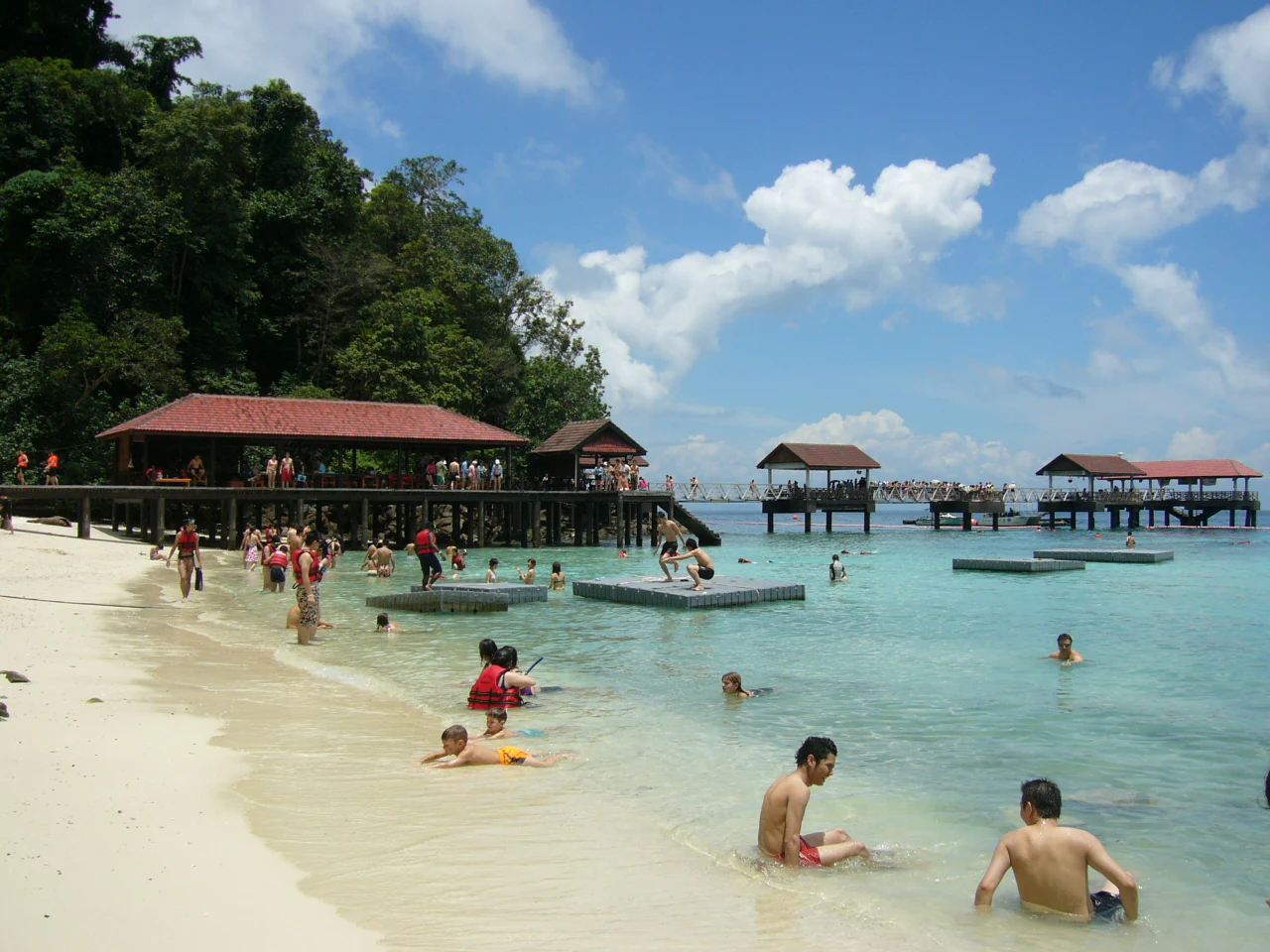
A group of people swimming and relaxing on a white sandy beach with wooden jetties and huts extending over the turquoise water.
Visitors enjoying the beach and clear waters at Payar Island Marine Park.

Payar Island Marine Park history and protected-area timeline

The marine park was officially gazetted in 1994 under the Fisheries Act 1985 (Amended 1993), establishing legal protection for the waters and islands around Payar. The decision to gazette the area reflected recognition of the reefs surrounding the islands as an ecologically valuable marine environment in the northern Strait of Malacca, and a place where endangered fish species and reef-building corals needed formal safeguarding.

For years after gazettement, the park functioned as both a conservation zone and a recreational destination, drawing increasing numbers of snorkellers and divers to its sheltered waters and signature sites such as the Coral Garden. The combination of accessibility from Langkawi, Kuala Kedah, and Penang made it one of the more heavily visited marine areas on the western coast of Peninsular Malaysia.

By the second half of 2010, the park experienced widespread coral bleaching linked to extreme sea water temperatures and pressure from visitor numbers exceeding what the reefs could comfortably sustain. Bleaching intensified again by 2016, exacerbated by an extended El Niño event that affected more than half of the reefs across Thai and Peninsular Malaysian waters. These events spurred management response: the Kedah Fisheries Department introduced stricter operational guidelines, registered only approved tour operators for access, and imposed limits on visitor numbers. Restrictions introduced around this period included weekly closures, reduced weekly visitor caps, and an annual closure window to allow the reefs to recover.

Payar Island Marine Park landscape and geographic character

Although Payar Island Marine Park is primarily a marine park, its landscape is defined by the relationship between small tropical islands and the reef systems that surround them. Payar Island, the largest landmass in the group, is a narrow island approximately 1.75 kilometres long and about 500 metres wide, with elevations reaching 80 to 90 metres above sea level. The interior is heavily vegetated, and the shoreline is a mix of limited sandy coast on the eastern side and steeper, wave-cut rocky terrain and cliffs elsewhere.

The real defining physical feature of the park, however, lies beneath and around the islands. The waters enclose shallow reef habitats with bright soft coral formations, including the well-known Coral Garden site, as well as submerged rocky structures and channels shaped by wave action. The group setting, with Payar as the main island and Kaca, Lembu, and Segantang as smaller companions, creates a varied reef mosaic that contributes to the park's ecological character and its appeal for marine exploration.

Payar Island Marine Park ecosystems, habitats, and plant life

The ecological identity of Payar Island Marine Park is rooted in its coral reef habitats and the marine communities they support. The reefs around the islands are populated by dense stands of soft corals and associated reef organisms, creating a habitat structure that supports a wide variety of fish and other marine life.

Beyond the reefs, the islands themselves contribute to the park's broader natural character. Payar Island is covered in dense tropical vegetation from shore to interior, and its cliffs and rocky shorelines provide perches and habitats for bird species and reptiles. The combination of vegetated island interiors, varied coastline morphology, and adjoining reef systems gives the park a layered ecological profile that extends from terrestrial cover down into the marine environment below.

Payar Island Marine Park wildlife and species highlights

Marine life is the most prominent component of the park's wildlife profile. The reefs around Payar support a diversity of fish species, including several classified as endangered, alongside the soft corals and other reef organisms that form the structural backbone of the habitat. The Coral Garden area in particular has been noted for the abundance and visual richness of its soft coral communities and the fish populations they attract.

The islands also host terrestrial wildlife that complements the marine character of the reserve. Endemic fruit bats, monitor lizards, and shore pit vipers have been recorded on Payar, and the island supports birdlife including the white-bellied sea eagle, the crested serpent eagle, and imperial pigeons, with around 21 wild bird species documented in the area. Together, the marine and terrestrial wildlife give the park a distinctive blend of reef and island biodiversity.

Payar Island Marine Park conservation status and protection priorities

Payar Island Marine Park exists primarily as a conservation instrument, gazetted in 1994 under Malaysian fisheries legislation to protect coral reef ecosystems, endangered fish species, and the broader marine biodiversity of the northern Strait of Malacca. Its designation reflects the recognition that the reef habitats around these islands are ecologically valuable and vulnerable, particularly in the context of warming seas and increasing human use.

The park's conservation significance became more visible after episodes of severe coral bleaching in 2010 and again during the prolonged El Niño event from 2015 onward, which affected more than half of the reefs in Thai and Peninsular Malaysian waters. In response, Malaysian authorities introduced visitor caps, weekly closures, an annual closure window, and stricter regulation of tour operators, alongside targeted area closures in heavily impacted zones. These measures have made Payar Island Marine Park an example of active reef management in a region where coral ecosystems are increasingly under threat from climate-related stress and tourism pressure.

Payar Island Marine Park cultural meaning and human context

There is no distinct cultural identity tied to Payar Island itself. The island is uninhabited in any sustained sense, with no permanent freshwater sources and only limited flat land, and its role is overwhelmingly defined by ecology, conservation, and marine recreation rather than by traditional human settlement or cultural heritage. The park's identity is instead tied to its setting in Kedah and its connectivity to nearby coastal communities that serve as departure points, including Kuala Kedah, Langkawi, and Penang, which form the broader regional context for visitors arriving at the reserve.

Top sights and standout views in Payar Island Marine Park

Payar Island Marine Park stands out for the combination of accessible reef environments, formal marine protection, and meaningful conservation management. Its signature Coral Garden site highlights the soft coral diversity that drew attention to the area in the first place, while its protected status and subsequent visitor management policies reflect how seriously the reefs are now being treated.

Equally notable is the park's role as a regional refuge for endangered fish species and as a case study in reef recovery, particularly after the bleaching events of 2010 and 2016. Together, these elements give the park a profile that is more than recreational: it is a working example of how a small island group in the Strait of Malacca can anchor both tourism and long-term marine biodiversity protection.

Best time to visit Payar Island Marine Park

The clearest seasonal dimension of visiting Payar Island Marine Park relates to the park's own conservation management rather than to weather alone. The park has at various points been closed to tourists between March and May each year, a window tied to reef recovery and reduced stress on bleaching-affected corals, which means that visiting outside that period aligns with the park's own preservation efforts.

More broadly, the marine character of the park means that calmer sea conditions and clearer water generally favour snorkelling and diving visibility, and these conditions are typically associated with the drier monsoon period along the northwestern coast of Peninsular Malaysia. Outside of the annual closure window, visitors can expect a tropical marine environment shaped by warm waters, reef biodiversity, and active management to balance recreational use with ecological protection.

Monthly climate preview

Track monthly precipitation shifts and average temperature ranges across the coordinate

Payar Island Marine Park Climate Normals and Long-Term Temperature Patterns

Historical data records long-term monthly temperature averages and precipitation levels across a representative coordinate in Payar Island Marine Park. Detailed monthly breakdowns provide expanded climatological context for studying annual environmental rhythms.
Annual mean28 °C
27 °C29 °C
Jan28°
Feb28°
Mar29°
Apr29°
May29°
Jun29°
Jul29°
Aug28°
Sep28°
Oct28°
Nov28°
Dec27°
Warmest month
April

29 °C

Coolest month
December

27.5 °C

Wettest month
October

9.3 mm/day

Driest month
February

1.9 mm/day

Park location guide

Geography guide, regional context, and park location map for Payar Island Marine Park

Payar Island Marine Park park geography, regions, and map view in Malaysia

Understand where Payar Island Marine Park sits in Malaysia through a broader geographic reading of the surrounding landscape, nearby location context, and its mapped position within the national park landscape.

How Payar Island Marine Park fits into Malaysia

Malaysia is a federal constitutional monarchy located in Southeast Asia. The country consists of 13 states and three federal territories, divided by the South China Sea into Peninsular Malaysia on the Indochinese Peninsula and East Malaysia on the island of Borneo. With a population of over 34 million, it achieved independence from Britain in 1957 and became a modern federation in 1963. The country is recognized for its multicultural population, tropical climate, and significant economic role in the region.

Wider geography shaping Payar Island Marine Park in Malaysia

Malaysia occupies a strategic position in Southeast Asia, split by the South China Sea into two distinct regions. Peninsular Malaysia lies on the Indochinese Peninsula, sharing a land border with Thailand to the north and maritime borders with Singapore, Vietnam, and Indonesia. East Malaysia occupies the northern portion of Borneo, sharing land borders with Brunei and Indonesia, and maritime borders with the Philippines and Vietnam. The country's terrain includes coastal plains, mountain ranges such as the Titiwangsa in the peninsula, and extensive tropical rainforests.

Map view of Payar Island Marine Park

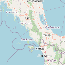
Use this park location map to pinpoint Payar Island Marine Park in Malaysia, understand its exact geographic position, and read its mapped placement within the surrounding landscape more clearly.

Pigeon | © OpenStreetMap contributors

Location context for Payar Island Marine Park

Kedah

Visual reference for island terrain, shallow reef habitats, and coral gardens

Payar Island Marine Park Photos and Protected Landscape Scenery

Visual records capture the tropical island terrain and protected marine habitats surrounding Payar Island Marine Park. Photographic documentation reveals soft coral formations and coastal topography across the Strait of Malacca.

A group of people swimming and relaxing on a white sandy beach with wooden jetties and huts extending over the turquoise water.

Park atlas

Compare surrounding marine reserves, island habitats, and regional coastal geographies.

Explore Protected Areas and Parks Near Payar Island Marine Park

Browse other protected areas and marine reserves located near Payar Island Marine Park in the northern Strait of Malacca. Comparing these adjacent coastal environments reveals broader patterns in regional reef conservation and tropical island ecosystems.
Stylized illustration of a forested area featuring a waterfall, large leaves, and a winding path
National parkSatun Province
About 47 km away#1 closest

North

Thale Ban National Park: Mapped Protected Landscape and Unique Wetland Ecosystem in Satun Province

Explore karst and granite mountains, natural lake geography, and diverse biodiversity.

Thale Ban National Park offers a fascinating study in protected landscape geography, centered around a rare natural lake formed by geological damming. This national park in Satun Province, Thailand, showcases a striking contrast between ancient limestone karst formations and younger granite mountains, contributing to its unique biodiversity and ecosystems. Its position near the Malaysian border highlights its role in regional conservation, making it a key site for understanding mapped terrain and protected natural areas.

Area
196 km²
Established
1980
IUCN
II
Visitors
12K annual
State or regional parkPerlis
About 59 km away#2 closest

North

Perlis State Park: Protected Limestone Hills and Forest Reserves in Northern Malaysia

Explore the karst geography of the Nakawan Range.

Perlis State Park protects approximately 5,000 hectares of hilly forest and rugged limestone karst terrain. This critical landscape provides important bird habitats and features a network of underground cave systems integrated into the Tenasserim Hills, offering a distinct geological profile within the state of Perlis.

Area
50 km²
Relief
Upland
Climate
Tropical
Scope
Terrestrial
National parkMalaysia
About 70 km away#3 closest

South

Penang National Park: Exploring Malaysia's National Park Atlas and Protected Landscapes

Understand the mapped geography and protected terrain of Penang National Park.

Penang National Park represents a crucial element within Malaysia's network of protected areas. This page offers detailed information for atlas-driven exploration, focusing on the park's specific geography, its mapped boundaries, and its contribution to the regional landscape. Gain a structured understanding of Penang National Park's identity as a protected national park, providing essential context for geographic discovery.

Area
12.13 km²
Established
2003
IUCN
II
Relief
Mixed relief
National parkSatun Province
About 73 km away#4 closest

Northwest

Tarutao National Park: National Park Exploration and Geographic Context in Satun Province

Mapped boundaries and regional landscape details await discovery.

Tarutao National Park stands as a protected national park entity, offering a specific focal point for exploring Thailand's natural landscapes within Satun Province. This page provides access to its protected-area identity and geographic mapping, essential for understanding its placement within the broader regional atlas. Investigate the park's distinct landscape features and its contribution to the protected areas of the Andaman Sea coast.

Area
1,490 km²
Established
1974
IUCN
II
Visitors
238.4K annual
National parkSongkhla Province
About 82 km away#5 closest

Northeast

Khao Nam Khang National Park: National Park, Mapped Boundaries, and Regional Geography

Explore protected landscape identity and atlas context.

Gain detailed insights into Khao Nam Khang National Park, a key protected area situated within Songkhla Province. This national park serves as a critical reference point for understanding regional geography, its specific mapped boundaries, and its role as a conservation landscape. Discover its unique geographic context, vital for comprehensive atlas exploration of Thailand's natural heritage.

Area
212 km²
Established
1990
IUCN
II
Visitors
1.8K annual
National parkThailand
About 104 km away#6 closest

Northwest

Mu Ko Phetra National Park: Thailand National Park Mapped Geography and Protected Landscape

Explore its mapped boundaries and regional atlas context.

Mu Ko Phetra National Park stands as a distinct protected area within Thailand, offering insights into its unique geographic setting. This detailed entry focuses on the park's mapped boundaries, its protected landscape characteristics, and its regional geography. Users can explore its placement within Thailand for a comprehensive understanding of its atlas significance and natural context.

Area
494 km²
Established
1984
IUCN
II
Visitors
129.9K annual
A watercolor painting showing a quiet lakeside scene with dense green forests in the background and soft, purplish mountains rising behind them.
State or regional parkPerak
About 156 km away#7 closest

East

Belum-Temengor: Ancient Rainforest Complex and Protected Landscape Geography in Perak

Mapping the forest ridges and lake archipelago of the northern Malay Peninsula

Spanning over 130 million years of ecological history, Belum-Temengor represents a massive, continuous block of tropical rainforest. The terrain transitions from high-altitude hill forests in the north to the flooded valleys and forested islands of Tasik Temengor. This complex serves as a vital water catchment and a sanctuary for diverse flora and fauna within the broader mountainous geography of the Perak region.

Area
1,175 km²
Established
2007
Relief
Mountain
Climate
Tropical
National parkThailand
About 163 km away#8 closest

Northwest

Mu Ko Lanta National Park: Protected National Park and Mapped Landscape in Thailand

Explore its boundaries within Thailand's regional geography.

Mu Ko Lanta National Park is a significant protected area within Thailand, defined by its national park status and distinct geographic features. This page facilitates structured discovery of its mapped landscape and the regional context it occupies. Users can explore its protected-area identity and understand how it fits into the broader atlas of natural landscapes in Southeast Asia, emphasizing geographic specificity and atlas-driven insights.

Area
134 km²
Established
1990
IUCN
II
Visitors
217.4K annual

Common questions about visiting, size, designation, and location context for Payar Island Marine Park

Payar Island Marine Park FAQs for park facts, access, geography, and protected area context

Find quick answers about Payar Island Marine Park, including protected-area facts, park geography, trail and visitor context, and how the park fits into its surrounding country and regional landscape.
MoriAtlas Explorer

Continue Your Protected Areas Search Across the Global Atlas

Deepen your exploration by continuing the structured search for national parks and protected areas worldwide. Utilize the comprehensive filtering capabilities to compare different conservation landscapes and refine your understanding of global park geography. Discover more about the distribution and characteristics of protected natural areas.

Global natural geography