Why Khao Nam Khang National Park stands out
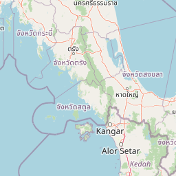
Khao Nam Khang National Park is distinctive for combining protected tropical rainforest ecosystems along the Thailand-Malaysia border with an unusual Cold War historical narrative. The park preserves the underground tunnel complex that served as the largest operational base for Malay Chinese communist insurgents during the 1960s through 1980s, now maintained as the Khao Nam Khang Historical Tunnel museum. The mountain's name reflecting persistent dew, the presence of the Malayan tapir as the park logo, and the network of forest waterfalls including Phru Ching, Ton Tat Fah, and Ton Lat further distinguish this park from other Thai protected areas.
Khao Nam Khang National Park history and protected-area timeline
The history of Khao Nam Khang National Park extends beyond its 1990 establishment to encompass the area's role as a communist insurgent base during the Cold War era. The mountainous border region between Thailand and Malaysia provided a remote and strategically advantageous location for Malay Chinese communist forces operating in the region from approximately the 1960s through the early 1980s. The complex tunnel system was constructed over approximately two years using manual labour, eventually becoming the largest such underground facility in Thailand with three passages extending to a depth of three levels, sixteen entrance and exit points, and approximately one kilometre of winding passages internally. The tunnels housed various functional spaces including meeting rooms, a radio room, a kitchen, a medical station, and a shooting range. Following the Thai government's "Operation Under the Cool Sky" policy combining military and political approaches, the insurgent base was successfully overrun on July 25, 1982, leading to the eventual dissolution of the communist movement in Thailand. The insurgents officially ceased hostilities and joined national development efforts in 1987. The tunnel complex has since been preserved and converted into a historical museum open to visitors, providing a tangible connection to this turbulent period while demonstrating the park's transition from conflict zone to protected natural area.
Khao Nam Khang National Park landscape and geographic character
The landscape of Khao Nam Khang National Park is defined by a complex mountain range forming part of the border highlands between Thailand and Malaysia. The terrain consists of interlocking mountain ridges and valleys creating a rugged topography with the park's highest point at Khao Nam Khang peak reaching 648 metres above mean sea level. Two additional significant peaks, Khao Saya and Khao Hai Mai, contribute to the mountainous character of the area. The underlying geology comprises predominantly limestone and granite formations, while soils generally consist of loam, clay, or sandy clay compositions. Multiple streams originate from the high ground, including Khlong Na Thawi, Khlong Thap Chang, and Khlong Sai Khao, which flow outwards from the park to serve the surrounding lowland areas. The landscape supports continuous tracts of tropical rainforest that connect with larger forest complexes in the region.
Khao Nam Khang National Park ecosystems, habitats, and plant life
The nature of Khao Nam Khang National Park centres on tropical rainforest ecosystems characteristic of the Sunda region in southern Thailand. The forest cover is dense and ecologically productive, supporting a diverse array of plant species including economically valuable trees such as Hopea odorata, various dipterocarp species, and members of the rose family. The understory contains numerous palm species, rattan, orchids, ferns, and mosses that thrive in the humid conditions. The park's climate is influenced by both the northeast and southwest monsoons, resulting in consistently high humidity and rainfall distributed throughout most of the year, with a rainy season extending from May through January and a shorter dry season from February to April. This climatic regime supports the evergreen nature of the forest and maintains the moisture conditions that give the mountain its characteristic dew.
Khao Nam Khang National Park wildlife and species highlights
The wildlife population in Khao Nam Khang National Park reflects the tropical forest environment and the park's position within the Indo-Malayan biodiversity region. Mammal species present include wild boar, sun bear, mainland serow, southern pig-tailed macaque, barking deer, gibbon, Malayan tapir, black leopard, mouse-deer, and palm civet. The Malayan tapir holds particular significance as the featured species in the park's official logo. The bird population includes several notable species such as hornbill, great argus, pheasant, green peacock, and green-legged partridge. These species occupy various ecological niches within the forest environment, from ground-dwelling mammals to canopy-dwelling birds, contributing to the overall biodiversity value of the protected area.
Khao Nam Khang National Park conservation status and protection priorities
Khao Nam Khang National Park contributes to Thailand's protected area network as an IUCN Category II designation representing national park status. The park protects continuous tracts of tropical rainforest in a region where such habitat has faced pressure from agricultural expansion and development. By preserving the watersheds originating from Khao Nam Khang peak, the park provides ecosystem services supporting downstream agricultural communities in Songkhla province. The conversion of the former insurgent base into a managed tourism site demonstrates how historical conflict areas can be redirect towards conservation and education purposes, allowing visitors to reflect on both the natural and historical dimensions of the landscape.
Khao Nam Khang National Park cultural meaning and human context
The cultural context of Khao Nam Khang National Park is uniquely shaped by its Cold War history as a communist insurgent stronghold. The area functioned for approximately four decades as an administrative and operational centre for Malay Chinese communist forces, who established an extensive underground tunnel network serving as their largest base in the region. Following the resolution of the insurgency and the integration of former combatants into Thai society in 1987, the site was preserved rather than demolished, transforming into a historical museum that provides educational context about this period of regional conflict. The tunnels represent a physical testament to this historical chapter, while the surrounding natural landscape has recovered to support the park's contemporary conservation mission.
Top sights and standout views in Khao Nam Khang National Park
The highlights of Khao Nam Khang National Park span natural and historical dimensions that together create a distinctive visitor experience. The Khao Nam Khang Historical Tunnel stands as the park's primary attraction, offering visitors the opportunity to explore a vast underground complex of tunnels, chambers, and passages that once served as a self-contained insurgent community including meeting rooms, a radio station, medical facilities, and storage areas. The waterfall network, particularly Phru Ching Waterfall as the tallest in the park, provides natural scenic value within the tropical forest setting. The recovering forest environment supports wildlife viewing opportunities, while the mountain trails offer access to the summit where the park's namesake dew phenomenon can be observed. The juxtaposition of pristine nature against the backdrop of recent human history creates a park experience unlike typical Thai protected areas.
Best time to visit Khao Nam Khang National Park
The best time to visit Khao Nam Khang National Park considers both weather conditions and the nature of available activities. The park experiences a rainy season from May through January when rainfall is frequent and sometimes heavy, while the dry season from February to April offers more consistent sunny weather for outdoor exploration. The monsoon-influenced climate means the forest remains lush throughout the year, though the period from February to April generally provides more comfortable conditions for hiking and waterfall visits. Visitors interested in exploring the historical tunnel should note that the site can be visited throughout the year, though avoiding the peak of the rainy season may allow for more comfortable movement around the park's outdoor attractions.