

Mori Atlas logo
State or regional parkPerlis State Park

A critical protected area encompassing the rugged limestone ridges of the Nakawan Range.

Perlis State Park: Mapping the Karst Landscapes and Protected Hill Ranges of Northern Malaysia

Perlis State Park preserves the dramatic karst landscape of the Nakawan Range along the international border between Malaysia and Thailand. Spanning the Mata Ayer and Wang Mu Forest Reserves, this protected area features limestone hills, complex cave systems, and diverse forest terrain. It serves as a vital sanctuary for birdlife and an integral component of the regional geography within the northernmost reaches of Peninsular Malaysia.

karst landscapelimestone hillscave systemstropical forestimportant bird areabirdwatching

Perlis State Park

State or regional park

Park overview

Structured park overview, official facts, and landscape profile for Perlis State Park

Perlis State Park park facts, protected area profile, and essential visitor context

Review the core facts for Perlis State Park, including designation, size, terrain, visitor scale, habitats, and operating context in one park-focused overview.

About Perlis State Park

Perlis State Park is a forested protected area in the far north of Peninsular Malaysia, centered on the Nakawan Range where Perlis meets Thailand. The park safeguards a representative portion of the Tenasserim Hills, a long northeasterly chain of low mountains and ridges that extends from Myanmar through Thailand and into northern Malaysia. Within this broader system, the Nakawan Range stands out for its karstic character, formed from ancient limestone of the Setul Group that has weathered into a broken landscape of hills, cliffs, sinkholes, and caves.

The park was gazetted around two forest reserves, Mata Ayer Forest Reserve and Wang Mu Forest Reserve, which together account for its core area. Their combined extent covers roughly 5,000 hectares, although the wider Nakawan Range extends along about 36 kilometers of the international boundary, with much of the ridgeline and additional forest continuing across into Satun province in Thailand. This cross-border continuity is one of the park's defining features, allowing wildlife and ecological processes to function across a larger landscape than the formal Malaysian protected area alone.

The park's identity is strongly tied to its landscape. Steep limestone ridges, dense tropical forest cover, and a network of caves define both the scenery and the visitor experience. The karst geology has produced notable cave systems, including Gua Kelam, a historically significant cave that has long drawn visitors to the area. Birdwatchers, in particular, regard the surrounding forests as one of Perlis's richest natural attractions, while runners and adventure seekers use the terrain for trail races and caving expeditions.

Quick facts and research context for Perlis State Park

Perlis State Park lies in northern Malaysia, occupying the Nakawan Range along the Perlis-Satun border. It encompasses around 5,000 hectares across two forest reserves: Mata Ayer and Wang Mu. The underlying geology belongs to the Setul Group, producing classic karst topography with limestone hills, caves, and forested slopes. The area was designated an Important Bird Area of Malaysia in 2007 and continues to attract birdwatchers and nature explorers.

Protection and recognition

Documented terrestrial protection scope and international recognition records

Perlis State Park Protection Status and Conservation Recognition

Perlis State Park maintains a documented terrestrial protection scope that anchors its formal conservation status within the regional protected area network. Comprehensive administrative records outline the governance framework, designated boundaries, and recognized international conservation listings.

Protection details

Protection scope
Terrestrial
Transboundary protection
No
Park context

Deeper park guide and search-rich context for Perlis State Park

Perlis State Park history, landscape, wildlife, and travel context

Explore Perlis State Park through its history, landscape character, ecosystems, wildlife, conservation priorities, cultural context, and seasonal travel timing in a structured park guide built for atlas discovery and search intent.

Why Perlis State Park stands out

Perlis State Park is best known for protecting the karst landscape of the Nakawan Range and for its exceptional birdlife. The contiguous forests on both the Malaysian and Thai sides of the border have been documented as an Important Bird Area, hosting more than 130 bird species in the surveyed area. The park is also recognized as a destination for caving, given the extensive limestone cave systems running through the range, and it hosts the Nakawan Ultra marathon, which uses the rugged terrain as a sporting challenge.

Perlis State Park history and protected-area timeline

Perlis State Park was established to protect the forested interior of the Nakawan Range, bringing together Mata Ayer Forest Reserve and Wang Mu Forest Reserve under a single park designation covering roughly 5,000 hectares. The underlying forest reserves themselves have a longer history of protection as state forest, but the park formalizes their role as a connected conservation landscape.

In 2007, the broader area was officially recognized for its ornithological importance when it was designated an Important Bird Area of Malaysia, reflecting years of bird surveys that documented a substantial list of bird species in the contiguous forest. Caving and adventure activities along the range have a parallel history, with the karst systems, including Gua Kelam, drawing visitors long before the park's formal consolidation. Today the park maintains its dual role as a biodiversity refuge and an outdoor recreation landscape for northern Perlis.

Perlis State Park landscape and geographic character

The Nakawan Range runs northeast to southwest along the Malaysia-Thailand border for roughly 36 kilometers, forming a long, broken spine of hills that defines northern Perlis. The terrain is classic karst: rugged limestone ridges, sharp breaks in slope, exposed rock faces, and a network of caves and underground drainage features shaped by the dissolution of Setul Group limestone over geological time.

Forested valleys and lower slopes blend into the karst uplands, producing a visually varied scene of dense green canopy punctuated by pale limestone outcrops. From vantage points such as Wang Kelian and the Timah Tasoh area, the range presents a dramatic backdrop to the surrounding countryside of Perlis. The cross-border nature of the range means that the same landscape continues into Thailand's Satun province, strengthening the park's sense of being part of a regional mountain system rather than an isolated preserve.

Perlis State Park ecosystems, habitats, and plant life

The park protects upland and hill forests growing on karstic limestone, an unusual substrate that shapes both vegetation patterns and soil development across the Nakawan Range. The combination of broken topography, varied slope exposure, and differing altitudes creates a mosaic of microhabitats within a relatively compact area. Continuous forest cover, much of it on terrain too steep or rocky for agriculture, supports a healthy structure of native trees and understory plants.

Ecologically, the park is significant because it forms part of the Tenasserim Hills, allowing forest-dependent species to move and persist across an extensive regional landscape. The karst environment, with its caves and rocky outcrops, adds habitat diversity beyond the forest itself, supporting specialized fauna that depend on cliffs, rock shelters, and underground spaces. The contiguous forest between Perlis State Park and the Thai side of the border enhances the area's role as a refuge for sensitive species.

Perlis State Park wildlife and species highlights

Wildlife is one of the park's strongest draws, particularly its birdlife. Birdwatchers have documented more than 130 unique bird species in the contiguous Important Bird Area spanning both sides of the Nakawan Range, a richness that reflects the unbroken forest cover, the altitudinal variation, and the park's position at the boundary between Malay and Indochinese biogeographic influences. This diversity led to the area's designation as an Important Bird Area of Malaysia in 2007.

Alongside birds, the karst and forest habitats support a broader community of forest wildlife typical of northern Peninsular Malaysia, including mammals, reptiles, and invertebrates associated with limestone and hill forest environments. The caves and rock systems offer shelter and roosting sites for bats and other cave-adapted species, while the forested ridges provide refuge for larger forest fauna moving through the Tenasserim system. Taken together, the wildlife profile reinforces Perlis State Park's standing as one of the state's most ecologically valuable protected landscapes.

Perlis State Park conservation status and protection priorities

Perlis State Park plays a key conservation role by protecting a representative block of the Nakawan Range, one of the few extensive karst forest systems remaining in northern Peninsular Malaysia. By bringing together Mata Ayer Forest Reserve and Wang Mu Forest Reserve, the park consolidates protection across roughly 5,000 hectares of forested terrain, much of it on rugged ground that would otherwise be vulnerable to encroachment.

The park's recognition as an Important Bird Area of Malaysia emphasizes its importance for avian conservation and reflects the regional value of the contiguous cross-border forests of the Tenasserim Hills. Maintaining forest continuity between Perlis and Satun is critical for long-term biodiversity, particularly for species sensitive to habitat fragmentation. The park's karst geology also adds a conservation dimension beyond forests alone, since the cave systems and limestone outcrops represent a non-renewable geological resource with their own ecological significance.

Perlis State Park cultural meaning and human context

The Nakawan Range has long shaped local life in northern Perlis, both as a natural landmark and as a source of livelihoods, traditional forest use, and cross-border interaction with communities in Thailand's Satun province. The karst systems, including Gua Kelam, hold cultural as well as natural value and have been part of local identity for generations. The park today represents an effort to balance the conservation of these landscapes with their continued role in regional life, including outdoor recreation and ecotourism.

Top sights and standout views in Perlis State Park

Perlis State Park's highlights center on its karst landscape, its rich birdlife, and its opportunities for adventure. The park's limestone ridges and caves, including Gua Kelam, define a distinctive terrain unusual within Peninsular Malaysia.

Above all, the park stands out as a sanctuary for birdwatching, with over 130 species recorded across the contiguous Important Bird Area and official recognition as a key bird habitat since 2007. Together, these qualities make the park a compact but unusually varied destination within Perlis, blending geology, ecology, and outdoor recreation in a single protected landscape.

Best time to visit Perlis State Park

Perlis State Park is influenced by Peninsular Malaysia's monsoon pattern, with drier months generally offering more comfortable conditions for hiking, caving, and birdwatching. The forested slopes and karst ridges are most accessible when weather is more stable, while wetter periods can make trails slippery and limit cave exploration. Birdwatchers often plan visits around the activity of resident and migrant species, taking advantage of the park's year-round bird diversity while enjoying cooler mornings in the early part of the year.

Monthly climate preview

Long-term monthly temperature averages and precipitation totals for Perlis State Park

Perlis State Park Climate Normals, Annual Temperature and Precipitation Rhythm

Perlis State Park exhibits a measured annual rhythm defined by long-term average temperatures spanning from 26.36 degrees Celsius to 28.59 degrees Celsius alongside variable monthly precipitation. Examining the complete twelve-month meteorological profile reveals detailed baseline patterns recorded across representative coordinates.
Annual mean27 °C
26 °C29 °C
Jan27°
Feb27°
Mar28°
Apr29°
May28°
Jun28°
Jul28°
Aug28°
Sep27°
Oct27°
Nov27°
Dec26°
Warmest month
April

28.6 °C

Coolest month
December

26.4 °C

Wettest month
October

9.6 mm/day

Driest month
February

1.5 mm/day

Park location guide

Geography guide, regional context, and park location map for Perlis State Park

Perlis State Park park geography, regions, and map view in Malaysia

Understand where Perlis State Park sits in Malaysia through a broader geographic reading of the surrounding landscape, nearby location context, and its mapped position within the national park landscape.

How Perlis State Park fits into Malaysia

Malaysia is a federal constitutional monarchy located in Southeast Asia. The country consists of 13 states and three federal territories, divided by the South China Sea into Peninsular Malaysia on the Indochinese Peninsula and East Malaysia on the island of Borneo. With a population of over 34 million, it achieved independence from Britain in 1957 and became a modern federation in 1963. The country is recognized for its multicultural population, tropical climate, and significant economic role in the region.

Wider geography shaping Perlis State Park in Malaysia

Malaysia occupies a strategic position in Southeast Asia, split by the South China Sea into two distinct regions. Peninsular Malaysia lies on the Indochinese Peninsula, sharing a land border with Thailand to the north and maritime borders with Singapore, Vietnam, and Indonesia. East Malaysia occupies the northern portion of Borneo, sharing land borders with Brunei and Indonesia, and maritime borders with the Philippines and Vietnam. The country's terrain includes coastal plains, mountain ranges such as the Titiwangsa in the peninsula, and extensive tropical rainforests.

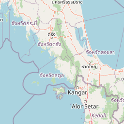
Map view of Perlis State Park

Use this park location map to pinpoint Perlis State Park in Malaysia, understand its exact geographic position, and read its mapped placement within the surrounding landscape more clearly.

Pigeon | © OpenStreetMap contributors

Location context for Perlis State Park

Perlis
Park atlas

Compare adjacent forest reserves and cross border mountain terrain

Parks Near Perlis State Park and Surrounding Protected Landscapes

Visitors exploring Perlis State Park can continue browsing nearby national parks and protected areas across the surrounding regional terrain. Extending the geographic review reveals connected limestone hills, contiguous forest reserves, and wider conservation landscapes.
Stylized illustration of a forested area featuring a waterfall, large leaves, and a winding path
National parkSatun Province
About 12 km away#1 closest

South

Thale Ban National Park: Mapped Protected Landscape and Unique Wetland Ecosystem in Satun Province

Explore karst and granite mountains, natural lake geography, and diverse biodiversity.

Thale Ban National Park offers a fascinating study in protected landscape geography, centered around a rare natural lake formed by geological damming. This national park in Satun Province, Thailand, showcases a striking contrast between ancient limestone karst formations and younger granite mountains, contributing to its unique biodiversity and ecosystems. Its position near the Malaysian border highlights its role in regional conservation, making it a key site for understanding mapped terrain and protected natural areas.

Area
196 km²
Established
1980
IUCN
II
Visitors
12K annual
National parkSongkhla Province
About 47 km away#2 closest

East

Khao Nam Khang National Park: National Park, Mapped Boundaries, and Regional Geography

Explore protected landscape identity and atlas context.

Gain detailed insights into Khao Nam Khang National Park, a key protected area situated within Songkhla Province. This national park serves as a critical reference point for understanding regional geography, its specific mapped boundaries, and its role as a conservation landscape. Discover its unique geographic context, vital for comprehensive atlas exploration of Thailand's natural heritage.

Area
212 km²
Established
1990
IUCN
II
Visitors
1.8K annual
Marine protected areaKedah
About 59 km away#3 closest

South

Payar Island Marine Park: A Comprehensive Geographic Atlas of Marine Protected Areas

Mapping reef systems and island geography in the northern Strait of Malacca.

Payar Island Marine Park serves as a significant marine protected area centered on the islands of Payar, Kaca, Lembu, and Segantang. This profile details the park's coastal geography, its signature soft coral habitats like the Coral Garden, and its role as a regional sanctuary for marine biodiversity within the Kedah territorial waters.

Area
0.29 km²
Established
1994
Relief
Upland
Climate
Tropical
National parkSatun Province
About 59 km away#4 closest

West

Tarutao National Park: National Park Exploration and Geographic Context in Satun Province

Mapped boundaries and regional landscape details await discovery.

Tarutao National Park stands as a protected national park entity, offering a specific focal point for exploring Thailand's natural landscapes within Satun Province. This page provides access to its protected-area identity and geographic mapping, essential for understanding its placement within the broader regional atlas. Investigate the park's distinct landscape features and its contribution to the protected areas of the Andaman Sea coast.

Area
1,490 km²
Established
1974
IUCN
II
Visitors
238.4K annual
National parkThailand
About 77 km away#5 closest

Northwest

Mu Ko Phetra National Park: Thailand National Park Mapped Geography and Protected Landscape

Explore its mapped boundaries and regional atlas context.

Mu Ko Phetra National Park stands as a distinct protected area within Thailand, offering insights into its unique geographic setting. This detailed entry focuses on the park's mapped boundaries, its protected landscape characteristics, and its regional geography. Users can explore its placement within Thailand for a comprehensive understanding of its atlas significance and natural context.

Area
494 km²
Established
1984
IUCN
II
Visitors
129.9K annual
National parkMalaysia
About 125 km away#6 closest

South

Penang National Park: Exploring Malaysia's National Park Atlas and Protected Landscapes

Understand the mapped geography and protected terrain of Penang National Park.

Penang National Park represents a crucial element within Malaysia's network of protected areas. This page offers detailed information for atlas-driven exploration, focusing on the park's specific geography, its mapped boundaries, and its contribution to the regional landscape. Gain a structured understanding of Penang National Park's identity as a protected national park, providing essential context for geographic discovery.

Area
12.13 km²
Established
2003
IUCN
II
Relief
Mixed relief
National parkTrang Province
About 130 km away#7 closest

Northwest

Hat Chao Mai National Park: National Park Protected Landscape and Geographic Context

Explore Trang Province's mapped protected areas and natural terrain.

Hat Chao Mai National Park serves as a focal point for understanding protected lands in Trang Province, Thailand. This entry offers insights into the park's specific geographic attributes and its designation as a national park. Users can explore the mapped boundaries and the surrounding regional geography, gaining a clear picture of this protected landscape within the MoriAtlas geographic framework. Understanding Hat Chao Mai National Park provides essential context for regional park exploration and mapped conservation areas.

Area
231 km²
Established
1981
IUCN
II
Visitors
83K annual
National parkThailand
About 138 km away#8 closest

Northwest

Mu Ko Lanta National Park: Protected National Park and Mapped Landscape in Thailand

Explore its boundaries within Thailand's regional geography.

Mu Ko Lanta National Park is a significant protected area within Thailand, defined by its national park status and distinct geographic features. This page facilitates structured discovery of its mapped landscape and the regional context it occupies. Users can explore its protected-area identity and understand how it fits into the broader atlas of natural landscapes in Southeast Asia, emphasizing geographic specificity and atlas-driven insights.

Area
134 km²
Established
1990
IUCN
II
Visitors
217.4K annual

Common questions about visiting, size, designation, and location context for Perlis State Park

Perlis State Park FAQs for park facts, access, geography, and protected area context

Find quick answers about Perlis State Park, including protected-area facts, park geography, trail and visitor context, and how the park fits into its surrounding country and regional landscape.
MoriAtlas Explorer

Continue Your Protected Areas Search Across the Global Atlas

Deepen your exploration by continuing the structured search for national parks and protected areas worldwide. Utilize the comprehensive filtering capabilities to compare different conservation landscapes and refine your understanding of global park geography. Discover more about the distribution and characteristics of protected natural areas.

Global natural geography
