Mori Atlas logo
Nature reserveRas Al Khor

Discover the mapped boundaries and natural context of Ras Al Khor within the Dubai region.

Ras Al Khor Nature Reserve: Dubai's Protected Landscape and Geographic Atlas Entry

(Ras Al Khor Wildlife Sanctuary)

Ras Al Khor represents a significant protected natural area situated within the vibrant geographic expanse of Dubai. As a designated nature reserve, it holds importance for understanding the regional landscape and conservation efforts. This entry provides a focused geographic lens, detailing the park's mapped boundaries and its context within the broader atlas of protected lands, enabling a precise exploration of its unique natural identity.

Wetland ReserveUrban Protected AreaBird SanctuaryRamsar SiteMangrove EcosystemMigratory Birds

Ras Al Khor

Nature reserve

Park overview

Structured park overview, official facts, and landscape profile for Ras Al Khor

Ras Al Khor park facts, protected area profile, and essential visitor context
Review the core facts for Ras Al Khor, including designation, size, terrain, visitor scale, habitats, and operating context in one park-focused overview.

About Ras Al Khor

Ras Al Khor Wildlife Sanctuary represents an extraordinary example of how modern cities can preserve and protect natural ecosystems within their boundaries. Situated along the historic Dubai Creek, this wetland reserve provides a living laboratory for urban biodiversity and serves as a sanctuary for both migratory and resident wildlife in the heart of one of the world's most dynamic metropolitan areas. The sanctuary's coastal mudflats, mangrove forests, and tidal channels create a complex habitat matrix that supports a remarkable diversity of species despite the surrounding urban development. Dubai Municipality has invested significantly in protecting this delicate ecosystem, establishing fenced boundaries, constructing birding hides, and implementing management practices that balance wildlife conservation with public access. The sanctuary has welcomed over 90,000 visitors from more than 100 countries, demonstrating the strong public interest in experiencing natural environments within the urban landscape. The location at what was historically the end of Dubai Creek gives the area deep historical roots in the region's development, while its transformation into a protected area reflects evolving priorities around environmental stewardship in the Emirate.

Quick facts and research context for Ras Al Khor

Ras Al Khor spans roughly 1,300 hectares along Dubai Creek in the heart of Dubai. It became a protected area in 1998 and was designated as a Ramsar Wetland in 2007. The sanctuary is characterized by coastal mudflats, mangrove stands, and shallow lagoons that support remarkable biodiversity. It is home to approximately 470 species of fauna and 47 types of flora. The sanctuary features three public birding hides offering free access to visitors, operating from early morning through late afternoon with seasonal schedule variations.

Park context

Deeper park guide and search-rich context for Ras Al Khor

Ras Al Khor history, landscape, wildlife, and travel context
Explore Ras Al Khor through its history, landscape character, ecosystems, wildlife, conservation priorities, cultural context, and seasonal travel timing in a structured park guide built for atlas discovery and search intent.

Why Ras Al Khor stands out

Ras Al Khor is best known for its spectacular concentrations of greater flamingos, which gather in large flocks along the shallow lagoon waters, creating one of the most photographed wildlife spectacles in the Arabian Peninsula. The sanctuary serves as a critical staging ground for migratory birds traveling between Europe, Africa, and Asia along the Central Asian flyway. Its unique position as an urban protected area, where visitors can observe wildlife against the backdrop of Dubai's skyscrapers, makes it a distinctive conservation success story in the Middle East.

Ras Al Khor history and protected-area timeline

Ras Al Khor emerged as a wildlife sanctuary through a combination of geographic importance and growing environmental awareness in Dubai. The area's historical significance as the terminus of Dubai Creek made it a natural focal point for the region's trade and settlement patterns. Following Dubai's rapid urban expansion in the late 20th century, the creek's eastern extension was modified with the construction of the Dubai Canal, fundamentally changing the water flow dynamics of the area. Recognizing the ecological value of the remaining wetland habitat, Dubai Municipality declared the area a Protected Area on March 1, 1998, establishing the legal framework for conservation. The partnership between Dubai Municipality's Environment Department and the WWF UAE Project Office, with sponsorship from the National Bank of Dubai, enabled the development of visitor infrastructure including the three birding hides that now serve the public. The designation as a Ramsar Wetland on August 29, 2007, cemented the sanctuary's international conservation status and placed it within the global network of important wetland ecosystems.

Ras Al Khor landscape and geographic character

The landscape of Ras Al Khor is defined by its coastal wetland character, featuring extensive mudflats, tidal channels, and scattered mangrove stands that create a distinctive ecological mosaic. The sanctuary occupies a low-lying coastal position where fresh and salt water intermix, producing brackish conditions that support specialized plant and animal communities. The terrain is predominantly flat, with subtle elevation changes that influence water drainage and create varying wetness zones across the reserve. Mangrove vegetation, primarily consisting of gray mangroves, provides structural complexity and serves as a critical habitat for numerous species. The shallow lagoon areas, particularly around the birding hides, offer ideal conditions for waterfowl congregation, with the open water providing unobstructed views for bird observation. The surrounding landscape presents a stark contrast between the natural wetland and the urban infrastructure of Dubai, with high-rise buildings visible from within the sanctuary, underscoring its unique position as an urban protected area.

Ras Al Khor ecosystems, habitats, and plant life

The ecological character of Ras Al Khor is shaped by its position as a coastal wetland where tidal influences create dynamic habitat conditions. The mangrove ecosystem represents one of the most productive marine habitats in the region, providing nursery grounds for fish and crustaceans while offering shelter and feeding areas for birds. The mudflats support rich invertebrate communities that form the base of the food web for many wading bird species. The mix of marine, brackish, and terrestrial habitats within a relatively compact area contributes to the sanctuary's high biodiversity despite its urban setting. Tidal cycles drive much of the sanctuary's ecological function, with water levels fluctuating to expose feeding areas for shorebirds at low tide and provide resting habitat for waterfowl at high tide. The protection from human disturbance through fencing and the provision of designated viewing areas has allowed wildlife to maintain natural behaviors within the sanctuary boundaries.

Ras Al Khor wildlife and species highlights

Ras Al Khor supports an impressive array of wildlife, with approximately 470 species of fauna documented within the sanctuary boundaries. Greater flamingos represent the most iconic residents, forming large flocks that feed in the shallow waters and create a defining visual element of the sanctuary. The wetland serves as a critical stopover for migratory birds traveling along the Central Asian flyway, with species including bar-headed geese, various shorebirds, and numerous waterfowl using the area for rest and refueling during their seasonal movements. Resident bird species such as grey herons, great egrets, and cormorants are commonly observed year-round. The aquatic environment supports populations of crustaceans, fish, and small mammals that form the base of the food web supporting the bird communities. The list of regular avian visitors includes over 40 species ranging from small passerines like wagtails and bulbuls to larger raptors including osprey and spotted eagle, creating exceptional birdwatching opportunities throughout the year.

Ras Al Khor conservation status and protection priorities

The designation of Ras Al Khor as a Ramsar Wetland places it within the international framework for wetland conservation, acknowledging its importance to the global network of significant wetlands. The sanctuary's conservation value is amplified by its urban location, demonstrating that rapid urban development and biodiversity protection can coexist when appropriate management measures are implemented. Dubai Municipality's efforts to protect the wetland have included physical barriers to limit human disturbance, creation of designated viewing areas that allow public access while protecting sensitive habitats, and ongoing monitoring of wildlife populations and habitat conditions. The partnership with international conservation organizations has brought technical expertise and resources to support the sanctuary's management. The Ramsar designation in 2007 reflected growing recognition of the wetland's role in supporting migratory bird populations that depend on a network of wetlands across multiple continents. The sanctuary serves as a model for urban protected areas in the Middle East, showing how cities can preserve natural heritage within their boundaries.

Ras Al Khor cultural meaning and human context

Ras Al Khor holds historical significance rooted in Dubai's development as a trading port along the Persian Gulf. The area marked the traditional end of Dubai Creek, where dhows and traditional vessels loaded and unloaded goods before the creek's extension through the Dubai Canal project. The name Ras Al Khor, meaning 'Head of the Creek,' preserves this historical connection to Dubai's maritime heritage. The sanctuary's location within the urban fabric of modern Dubai creates a distinctive cultural dimension, where visitors can experience natural ecosystems in sharp contrast to the surrounding commercial and residential development. The sanctuary provides an educational resource for Dubai's residents and visitors, offering opportunities to learn about the region's natural history and the importance of wetland conservation. The free access policy and central location make the sanctuary accessible to a broad audience, supporting environmental awareness and appreciation of the emirate's natural heritage.

Top sights and standout views in Ras Al Khor

The three birding hides at Ras Al Khor offer visitors exceptional opportunities to observe wildlife, with the flamingo hide providing close views of the large flamingo flocks that congregate in the main lagoon. The contrast between the natural wetland environment and the backdrop of Dubai's skyline creates a uniquely photogenic setting that distinguishes this sanctuary from other urban parks worldwide. The diversity of bird species present throughout the year, from seasonal migratory visitors to resident breeding populations, ensures rewarding birdwatching opportunities in every season. The free admission and convenient location within Dubai make the sanctuary accessible to all visitors, providing a rare opportunity to experience natural ecosystems without leaving the city.

Best time to visit Ras Al Khor

The cooler winter months from October through March generally offer the most comfortable conditions for visiting Ras Al Khor, with temperatures suitable for extended time outdoors and the peak period for migratory bird arrivals. During winter, the sanctuary operates from 7:30am to 5:30pm, and large numbers of flamingos and other waterfowl are typically present. Summer months bring higher temperatures, with the sanctuary extending hours to 6:00am to 6:00pm to accommodate early morning visits when conditions are cooler. The wetter months from December to March often see increased water levels that create ideal habitat conditions for waterfowl. Early morning visits generally offer the best bird observation opportunities, as birds are most active during the cooler hours and the light conditions are favorable for photography. Regardless of season, the sanctuary provides meaningful wildlife viewing opportunities year-round.
Park location guide

Geography guide, regional context, and park location map for Ras Al Khor

Ras Al Khor park geography, regions, and map view in United Arab Emirates
Understand where Ras Al Khor sits in United Arab Emirates through a broader geographic reading of the surrounding landscape, nearby location context, and its mapped position within the national park landscape.

How Ras Al Khor fits into United Arab Emirates

The UAE is a federation of seven emirates established as an independent nation in December 1971, formerly part of the British Trucial States. It has transformed from a desert region reliant on pearling and trade into a modern, affluent country with a diversified economy based on oil, trade, and services. The country borders Oman and Saudi Arabia and has maritime borders with Qatar, Iran, and Oman.

Wider geography shaping Ras Al Khor in United Arab Emirates

The UAE is situated on the eastern Arabian Peninsula, bordering Oman to the east and northeast, and Saudi Arabia to the southwest. The country has coastlines along the Persian Gulf to the north and west and the Gulf of Oman to the east. The terrain is predominantly desert with scattered oases, and there are mountainous areas in the eastern emirates near the Oman border.

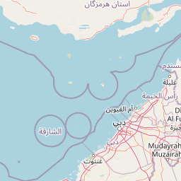
Map view of Ras Al Khor

Use this park location map to pinpoint Ras Al Khor in United Arab Emirates, understand its exact geographic position, and read its mapped placement within the surrounding landscape more clearly.

Pigeon | © OpenStreetMap contributors

Location context for Ras Al Khor

Dubai
Park atlas

Trace Dubai's diverse protected landscapes, comparing coastal wetlands and conservation efforts beyond Ras Al Khor.

Explore Other Protected Areas Near Ras Al Khor, Comparing Wetland Sanctuaries and Urban Nature in Dubai
After exploring Ras Al Khor Wildlife Sanctuary, browse other protected areas within Dubai and the surrounding region to compare unique wetland ecosystems and critical conservation sites. This atlas view offers comprehensive geographic context, allowing users to trace the spread of protected landscapes and understand regional biodiversity patterns.
Nature reserveEmirate of Dubai

Al Wohoosh Desert Conservation Reserve Nature Reserve: Mapped Protected Landscape

Desert terrain and geographic context in the Emirate of Dubai.

Delve into the Al Wohoosh Desert Conservation Reserve, a key protected natural area situated in the Emirate of Dubai. This entry focuses on its mapped geography, showcasing the desert landscape and its protected boundaries. Gain structured insights into its role as a nature reserve and its contribution to understanding regional conservation landscapes and mapped terrain.

Area
15.06 km²
Established
2014
Relief
Lowland
Climate
Arid
Nature reserveDubai

Al Marmoom Desert Conservation Reserve: Nature Reserve and Desert Landscape in Dubai

Mapped Geography and Protected Area Context

Explore the Al Marmoom Desert Conservation Reserve, a designated nature reserve located near Dubai. This protected area is crucial for understanding the region's desert geography and landscape. MoriAtlas provides detailed mapping and geographic context, allowing for in-depth study of its protected boundaries and its significance within the UAE's conservation landscape.

Area
0.4 km²
Established
2018
Relief
Lowland
Climate
Arid
Nature reserveDubai

Dubai Desert Conservation Reserve: Nature Reserve, Mapped Geography, and Protected Landscape Context

Explore the natural terrain and conservation atlas of this UAE protected area.

This page details the Dubai Desert Conservation Reserve, a designated nature reserve situated within the geographic scope of Dubai, United Arab Emirates. Dive into its mapped boundaries, understand its role as a protected landscape, and gain insight into its unique natural terrain. MoriAtlas provides structured data to explore the park's place within regional geography and the broader atlas of protected areas.

Area
225 km²
Established
2003
Relief
Lowland
Climate
Arid
Wildlife reserve

Al Saleel National Park: A Protected Acacia Forest Wildlife Reserve in Oman

Explore its unique landscape and protected area geography.

Al Saleel National Park in Oman is distinguished by its exceptional acacia forest ecosystem, a scarce habitat type across the Arabian Peninsula. Covering 220 square kilometers, this wildlife reserve serves as a crucial sanctuary for at-risk species like the Arabian gazelle and the endemic Omani wild cat. Its landscape offers a compelling study of arid zone forest ecology and protected area management, providing valuable context for understanding Oman's commitment to natural heritage and conservation within its regional geography.

Area
220 km²
Climate
Arid
Scope
Terrestrial
Water
No major water
National parkBalochistan

Hingol National Park: Pakistan's Unique Protected Landscape and Geological Atlas

Discover dramatic rock formations and coastal geography.

Hingol National Park stands as a monumental protected landscape within Balochistan, Pakistan, offering an unparalleled atlas view of geological diversity. Renowned for its hoodoos like the Princess of Hope and the Balochistan Sphinx, the park also features active mud volcanoes and striking coastal semi-desert terrain. The confluence of the Hingol River with the Arabian Sea creates important wetland habitats. This national park provides a rich context for exploring unique natural formations and regional geography, making it a significant point of discovery within Pakistan's protected areas.

Area
6,100 km²
Established
1988
IUCN
II
Relief
Mixed relief
National parkIran

Kavir National Park: A Major Protected Desert Landscape in Iran

Explore its arid terrain, conservation significance, and mapped boundaries.

Kavir National Park stands as a significant protected area within Iran, encompassing a vast 4,000 square kilometer expanse of desert and steppe landscapes on the western flank of the Kavir Desert. Designated as a national park, it plays a crucial role in preserving one of the Middle East's most extensive arid ecosystems and serves as a critical sanctuary for endangered species, including the Asiatic cheetah and Persian leopard. Its stark, open terrain offers a profound example of Iran's natural heritage and provides essential data for understanding regional geography and protected land distribution.

Area
4,000 km²
Established
1982
IUCN
II
Relief
Lowland
Protected areaSaudi Arabia

'Uruq Bani Ma'arid Protected Area: Saudi Arabian Landscape and Geographic Context

Mapped protected area boundaries and regional geography.

Delve into the specific protected area identity of 'Uruq Bani Ma'arid. This entry provides essential geographic context, detailing its mapped boundaries and its role within the diverse landscape of Saudi Arabia. Understand how this protected land fits into the broader atlas of the Arabian Peninsula, focusing on its unique regional geography and mapped terrain.

Area
12,765 km²
Relief
Mixed relief
Climate
Arid
Access
Highly restricted
National parkTehran Province

Sorkheh Hesar National Park: Protected Mountain Forest Landscape Near Tehran

Explore its mapped terrain and regional protected area context.

Sorkheh Hesar National Park stands as a significant protected forest area within Tehran Province, Iran. Spanning 9,380 hectares, this mountainous national park is characterized by its unique semi-arid climate and crucial role in conserving threatened species, including the Persian fallow deer and Persian leopard. The Jajrood River flows through its landscape, enhancing biodiversity and supporting a rich forest ecosystem. Its proximity to Tehran makes it a notable example of urban-adjacent conservation, offering valuable insights into protected land management and regional geography.

Area
93.8 km²
Established
1980
IUCN
II
Climate
Arid

Common questions about visiting, size, designation, and location context for Ras Al Khor

Ras Al Khor FAQs for park facts, access, geography, and protected area context
Find quick answers about Ras Al Khor, including protected-area facts, park geography, trail and visitor context, and how the park fits into its surrounding country and regional landscape.
MoriAtlas Explorer

Continue Your Protected Areas Search Across the Global Atlas

Deepen your exploration by continuing the structured search for national parks and protected areas worldwide. Utilize the comprehensive filtering capabilities to compare different conservation landscapes and refine your understanding of global park geography. Discover more about the distribution and characteristics of protected natural areas.

Global natural geography