

Mori Atlas logo
National parkSabangau National Park

Explore the mapped boundaries and regional geography of this Indonesian protected area.

Sabangau National Park: A Protected National Park Landscape in Central Kalimantan

Sabangau National Park represents a key protected landscape within the vast geography of Indonesia's Central Kalimantan province. As a designated national park, its boundaries define a significant area for ecological and geographic study. This page offers a focused entry into understanding Sabangau National Park's specific location, its role as a mapped protected territory, and its contribution to the broader natural landscape context of Borneo.

Peat swamp forestOrangutan habitatBorneo wildlifeNational parkTropical forestConservation area

Sabangau National Park

National park

Park overview

Structured park overview, official facts, and landscape profile for Sabangau National Park

Sabangau National Park park facts, protected area profile, and essential visitor context
Review the core facts for Sabangau National Park, including designation, size, terrain, visitor scale, habitats, and operating context in one park-focused overview.

About Sabangau National Park

Sabangau National Park represents one of the most ecologically significant protected areas in Indonesian Borneo, established in 2004 to protect the remarkable Sabangau peat swamp forest ecosystem. The park is centered on the Sabangau River, a blackwater river that flows through an extensive peat swamp complex situated between the Katingan and Kahayan rivers in Central Kalimantan province. This region contains one of the largest remaining tracts of peat swamp forest on the island of Borneo, spanning approximately 5,300 square kilometers within the broader forest complex. The ecosystem's defining characteristic is its dual nature, where diverse tropical tree species flourish atop a thick layer of partially decayed, waterlogged plant material that can reach depths of 10 to 12 meters, which in turn covers relatively infertile soils. The park's location near the regional capital of Palangka Raya places it within a region of significant human development pressure, though the western portions of the forest have been designated for protection as either national park or national laboratory research area. Despite extensive historical degradation, the area retains substantial ecological value and serves as a critical refuge for Borneo biodiversity.

Quick facts and research context for Sabangau National Park

Sabangau National Park occupies a vast peat swamp landscape in Central Kalimantan, Indonesian Borneo. The park was established in 2004 and covers an area of 5,687 square kilometers, making it one of the larger protected areas in the region. The ecosystem is characterized by its blackwater river system and the distinctive peat substrate that can reach depths of 10 to 12 meters. Located near the regional capital of Palangka Raya, the park sits within the broader Sabangau peat swamp forest complex spanning approximately 5,300 square kilometers. The protected area falls under IUCN Category II classification and is managed by the Indonesian Ministry of Forestry.

Park context

Deeper park guide and search-rich context for Sabangau National Park

Sabangau National Park history, landscape, wildlife, and travel context
Explore Sabangau National Park through its history, landscape character, ecosystems, wildlife, conservation priorities, cultural context, and seasonal travel timing in a structured park guide built for atlas discovery and search intent.

Why Sabangau National Park stands out

Sabangau National Park is best known for harboring the world's largest remaining orangutan population, estimated at nearly 7,000 individuals. The park's extensive peat swamp forest ecosystem represents a critical habitat for these great apes and numerous other species. The Sabangau catchment also supports substantial populations of agile gibbons, though these are declining rapidly. The area has been recognized by BirdLife International as an Important Bird Area, protecting vulnerable species including the large green pigeon and potentially Storm's stork and lesser adjutant. The park's ecological significance is heightened by its proximity to one of Borneo's rapidly developing regional centers.

Sabangau National Park history and protected-area timeline

Sabangau National Park's recent history is marked by significant human pressure and environmental transformation. Between 1980 and 1995, the area that now comprises the park was designated as a massive logging concessions area, during which time large-scale commercial timber extraction occurred across the region. Following the expiration of these formal logging concessions in 1995, the area became subject to widespread illegal logging activities that continued for many years. This combination of legal and illegal forestry operations resulted in the destruction of up to 85 percent of what is now the park's total area. The eastern portion of the forest, situated between the Sabangau and Kahayan rivers, became so severely degraded that it was officially designated for agricultural conversion. However, the ambitious Mega Rice Project, which attempted to drain large areas of peat forest to create rice paddies, ultimately failed, and no further significant efforts to convert this land for agriculture have been undertaken. By 2012, less than 1 percent of the park's total area had been reforested, and at current restoration rates, returning the forest to its pre-logged condition would require several centuries. The park was formally established as a national park in 2004 under the management of the Indonesian Ministry of Forestry.

Sabangau National Park landscape and geographic character

The physical landscape of Sabangau National Park is defined by its distinctive peat swamp environment. The terrain is dominated by vast, flat peatlands interspersed with the slow-moving channels of the Sabangau River and its tributaries. The blackwater river derives its color from the tannins leached from the surrounding vegetation and peat, creating a characteristic dark water appearance. The peat layer itself represents accumulated organic material that has partially decomposed in the waterlogged conditions, building up over thousands of years to form a substrate that can reach depths of 10 to 12 meters beneath the forest floor. The terrain is remarkably flat, typical of lowland tropical peat swamps, with minimal topographic relief across the extensive landscape. Satellite imagery reveals a grid-like pattern of logging roads that penetrate much of the forest area, a legacy of the extensive logging activities that have shaped the region. The western portions of the park retain more intact forest cover, while the eastern areas show the scars of extensive human modification.

Sabangau National Park ecosystems, habitats, and plant life

The nature of Sabangau National Park centers on its unique peat swamp forest ecosystem, one of the most distinctive habitat types in tropical Southeast Asia. This ecosystem supports a complex community of tropical tree species adapted to the waterlogged, acidic conditions of the peat substrate. The forest floor remains saturated for much of the year, creating conditions that slow decomposition and allow organic material to accumulate over long periods. The dual nature of the ecosystem, with living trees standing atop thick peat deposits that in turn cover mineral soils, creates a layered environment supporting diverse ecological interactions. Studies have demonstrated that despite the extensive degradation, the hydrological integrity of the forest has been largely maintained, meaning the ecosystem retains considerable ecological resilience. The park forms part of a broader network of peat swamp forests in Central Kalimantan that serve as critical carbon stores and biodiversity refuges. The area's proximity to Palangka Raya places significant development pressure on the ecosystem, though the western sections have received formal protection status.

Sabangau National Park wildlife and species highlights

Sabangau National Park supports exceptional wildlife diversity, most notably hosting the world's largest orangutan population. Surveys conducted in 2003 estimated approximately 6,910 individuals within the Sabangau catchment, representing a globally significant concentration of this critically endangered great ape species. The orangutans rely on the forest for their survival, using the canopy for feeding, resting, and social activities, though the fragmentation of forest cover has impaired their ability to move freely across the landscape. The park also supports substantial populations of agile gibbons, with estimated numbers in the tens of thousands across the Sabangau catchment, though these populations are declining rapidly due to habitat loss and fragmentation. The bird fauna includes several species of conservation concern, particularly the large green pigeon, which is classified as vulnerable. Storm's stork and lesser adjutant may also be present, though their status in the park remains less certain. The Important Bird Area designation by BirdLife International encompasses some 150,000 hectares of swamp forest within the broader complex, recognizing the site's significance for vulnerable bird species and broader biodiversity conservation.

Sabangau National Park conservation status and protection priorities

Sabangau National Park holds major conservation significance as a refuge for Borneo orangutans and other threatened species in an increasingly fragmented landscape. The park protects what remains of a once extensive peat swamp forest ecosystem that has been heavily impacted by logging activities, both legal and illegal. The establishment of the protected area in 2004 represented a formal commitment to preserving this critical habitat, though the challenges facing the ecosystem are substantial. With up to 85 percent of the original forest having been destroyed and less than 1 percent reforested by 2012, the trajectory of ecosystem degradation remains a serious concern. The conservation value of the western portions of the park has been enhanced by their designation as either National Park or National Laboratory Research Area, providing additional institutional protection. Ongoing efforts to establish long-term ecological monitoring within the forest represent an important step toward understanding and addressing the pressures facing this ecosystem. The park's status as an Important Bird Area further underscores its international conservation recognition.

Sabangau National Park cultural meaning and human context

The cultural context of Sabangau National Park is intertwined with the broader human geography of Central Kalimantan, a region with deep connections to river-based communities and traditional land use patterns. The park lies in an area that has experienced significant development pressure from the expansion of Palangka Raya, the regional capital that has grown substantially in recent decades. The historical allocation of large areas to logging concessions between 1980 and 1995 reflects the economic priorities that have shaped land use in the province. The failed Mega Rice Project represents a major chapter in the region's development history, an ambitious scheme that attempted to convert extensive peat forest to agricultural production but ultimately proved ecologically and practically unworkable. The local communities in the surrounding areas maintain connections to the rivers and forests, though the extensive environmental changes of recent decades have altered traditional livelihoods. The park's proximity to a major urban center creates both challenges and opportunities for conservation, as development pressures compete with the need to protect critical habitat.

Top sights and standout views in Sabangau National Park

Sabangau National Park stands out as a critical conservation landscape in Borneo, protecting the world's largest orangutan population within a vast peat swamp forest ecosystem. The park's 5,687 square kilometers encompass one of the largest remaining tracts of peat swamp forest in the region, a distinctive habitat characterized by its blackwater rivers, thick peat layers, and unique ecological communities. The combination of exceptional biodiversity value, including orangutans, gibbons, and vulnerable bird species, with significant conservation challenges makes this park both globally significant and urgently in need of effective protection. The landscape represents a complex interplay between ecological resilience and human pressure, with the western portions retaining better forest cover while the eastern areas show extensive degradation. The ongoing restoration challenges, with current rates suggesting centuries would be needed to fully recover the ecosystem, underscore the long-term commitment required to preserve this remarkable area.

Best time to visit Sabangau National Park

The optimal time to visit Sabangau National Park would align with the drier conditions typically experienced in Indonesian Borneo from March through October, when rainfall is reduced and river access is more reliable for wildlife observation. The wet season from November through February brings increased precipitation that can affect travel within the park's extensive peat swamp terrain. The dry season offers better opportunities for exploring the forest and observing wildlife, though the characteristic humidity of the tropical environment remains significant year-round. Visitors should be aware that the park's accessibility is influenced by the wet/dry seasonal patterns and that conditions can vary significantly from year to year based on broader climatic patterns. The proximity to Palangka Raya provides a practical base for park access, though visits require careful planning given the extensive areas involved and the need to work with local conservation authorities.

Park location guide

Geography guide, regional context, and park location map for Sabangau National Park

Sabangau National Park park geography, regions, and map view in Indonesia
Understand where Sabangau National Park sits in Indonesia through a broader geographic reading of the surrounding landscape, nearby location context, and its mapped position within the national park landscape.

How Sabangau National Park fits into Indonesia

Indonesia is a vast archipelagic nation in Southeast Asia and Oceania, spanning over 17,000 islands between the Indian and Pacific Oceans. As the world's fourth-most populous country with 288 million people, it features extraordinary cultural and biological diversity, withJavanese and Sundanese being the largest ethnic groups. The country gained independence from the Netherlands in 1945 and operates as a unitary presidential republic.

Wider geography shaping Sabangau National Park in Indonesia

Indonesia is situated in Southeast Asia and Oceania, spanning the equatorial region between the Indian Ocean to the west and the Pacific Ocean to the east. The archipelago includes major islands such as Sumatra, Java, Sulawesi, and parts of Borneo and New Guinea. It borders Papua New Guinea, Timor-Leste, and Malaysia by land, with extensive maritime boundaries throughout the region.

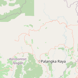
Map view of Sabangau National Park

Use this park location map to pinpoint Sabangau National Park in Indonesia, understand its exact geographic position, and read its mapped placement within the surrounding landscape more clearly.

Pigeon | © OpenStreetMap contributors

Location context for Sabangau National Park

Central Kalimantan
Park atlas

Trace the regional spread of protected peat swamp forests and other conservation landscapes surrounding Sabangau National Park's unique ecosystem.

Browse Related National Parks and Protected Areas Near Sabangau National Park
After exploring Sabangau National Park, continue your discovery of Indonesia's rich protected areas, focusing on those within Borneo's distinct peat swamp forest ecosystems and surrounding regions. Compare varied national parks, map their geographic spread, and understand the broader conservation efforts across Central Kalimantan and adjacent landscapes, extending your atlas-based exploration.
National parkCentral Kalimantan

Bukit Baka Bukit Raya National Park: Central Kalimantan's Protected Montane Rainforest Landscape

Explore the geographic core of Borneo's Schwaner mountain range.

Bukit Baka Bukit Raya National Park is a critical national park situated in Central Kalimantan, Indonesia, recognized for its extensive montane tropical rainforests and rugged topography. The park's landscape is dominated by the Schwaner mountain range, featuring prominent peaks like Bukit Raya, and functions as a vital watershed and biodiversity corridor. This protected area offers a rich subject for understanding regional geography, mapped landscapes, and the significance of Borneo's natural heritage within an atlas context.

Area
1,810 km²
Established
1992
IUCN
II
Relief
Mountain
National parkWest Kalimantan

Betung Kerihun National Park: West Kalimantan's National Park Geography and Mapped Boundaries

Explore protected area landscape context in Indonesia.

Betung Kerihun National Park is a significant protected area within West Kalimantan, Indonesia, identified as a national park. This entry provides detailed atlas-style exploration of its mapped geographic boundaries and landscape context. Understand its place within the regional geography and the broader network of protected lands, offering a foundation for appreciating its natural setting.

Area
8,000 km²
Established
1995
IUCN
II
Relief
Mountain
National parkSri Aman Division

Batang Ai National Park: National Park Landscape and Geographic Discovery

Explore the protected terrain and mapped boundaries of Sri Aman Division.

Batang Ai National Park serves as a distinct national park entity, vital for understanding the protected landscape and regional geography of Malaysia's Sri Aman Division. This resource offers detailed insights into the park's geographic scope, its mapped boundaries, and the natural terrain it encompasses, enabling structured exploration for atlas enthusiasts and geography researchers.

Area
24 km²
Established
1991
IUCN
II
Relief
Lowland
National parkEast Kalimantan

Kutai National Park: Protected Area Details and East Kalimantan Geography

Explore the mapped boundaries and regional landscape context.

Kutai National Park, a designated national park in Indonesia's East Kalimantan region, offers rich opportunities for geographic discovery. This resource focuses on the park's protected area status, its distinct landscape characteristics, and its mapped distribution within the broader regional geography. Gain a structured understanding of Kutai National Park's environmental significance and its contribution to conservation landscapes through detailed map context and geographic analysis.

Area
1,986 km²
Established
1982
IUCN
II
Relief
Lowland
National parkMalaysia

Maludam National Park: Southeast Asian Protected Landscape and National Park Geography

Mapped boundaries and natural terrain in Malaysia.

Maludam National Park offers a focused exploration of protected landscape identity and geographic context within Malaysia. As a designated national park, it serves as a vital component for understanding the distribution of protected areas and their mapped terrain. This detailed entry allows for an appreciation of the park's specific environmental character and its contribution to the broader atlas of natural landscapes in Southeast Asia, facilitating structured discovery for researchers and explorers.

Area
432 km²
Established
2000
IUCN
II
Relief
Lowland
National parkSarawak

Rajang Mangroves National Park: Borneo's Premier Mangrove Protected Landscape

Explore the mapped geography and wetland conservation of this Sarawak national park.

Rajang Mangroves National Park is a significant protected area dedicated to preserving the intricate mangrove swamp ecosystems of Sarawak's Rajang River delta. Encompassing a vast expanse of tidal channels and riverine forests, this national park serves as a critical habitat for unique wildlife and plays a vital role in coastal ecological health. Its landscape is defined by the dynamic interface between riverine and marine environments, offering a prime example of wetland conservation within Borneo's broader natural geography and atlas context.

Area
107 km²
Established
2000
IUCN
II
Relief
Lowland
Watercolor illustration of a coastal landscape with a distinctive rock formation, green vegetation, and calm water under a soft sky with distant mountains
National parkKuching Division

Bako National Park: Sarawak's Oldest National Park and Coastal Protected Landscape

Explore diverse ecosystems and dramatic mapped geology near Kuching Division.

Bako National Park, the oldest national park in Sarawak, Malaysia, offers a profound study in ecological concentration and geological drama. Covering a mere 27 square kilometers on the Muara Tebas peninsula, it encapsulates seven distinct ecosystem types, from coastal heath forest to mangrove areas, supporting significant biodiversity. The park's protected landscape is defined by its stunning sandstone coastline, carved by the sea into cliffs, arches, and seastacks, providing a unique geographic context. This makes Bako an essential destination for understanding Borneo's environmental diversity and the mapped boundaries of its conservation areas.

Area
27.27 km²
Established
1957
IUCN
II
Relief
Mixed relief
National parkSarawak

Kubah National Park: National Park Status and Mapped Landscape in Sarawak

Explore its protected boundaries and geographic context within Borneo.

Kubah National Park is a protected national park located in Sarawak, Malaysia, representing a crucial element of the region's conservation landscape. This detailed entry focuses on its identity as a national park, its specific geographic placement within Sarawak, and its significance for map-based exploration. Users can investigate the mapped boundaries and understand how Kubah National Park fits into the larger atlas of protected areas in East Malaysia, providing a factual foundation for geographic discovery without travel advice.

Area
22.3 km²
Established
1989
IUCN
II
Visitors
45K annual

Common questions about visiting, size, designation, and location context for Sabangau National Park

Sabangau National Park FAQs for park facts, access, geography, and protected area context
Find quick answers about Sabangau National Park, including protected-area facts, park geography, trail and visitor context, and how the park fits into its surrounding country and regional landscape.
MoriAtlas Explorer

Continue Your Protected Areas Search Across the Global Atlas

Deepen your exploration by continuing the structured search for national parks and protected areas worldwide. Utilize the comprehensive filtering capabilities to compare different conservation landscapes and refine your understanding of global park geography. Discover more about the distribution and characteristics of protected natural areas.

Global natural geography