
Streams
Park geography
A comprehensive geographic analysis of administrative placement and physical terrain structures
Saguaro National Park Geography: Detailed Mapped Boundaries and Natural Terrain Profiles
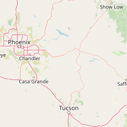
Examine the formal geographic boundaries of Saguaro National Park located in Pima County, Arizona. This profile covers the total land area of 371.16 square kilometers, identifying significant elevation gradients from 664 to 2641 meters and documented mountain peaks within the protected landscape.
Related tags
Sonoran DesertArizona National ParksDesert LandscapeSky IslandsCactus Ecosystems
Arizona's iconic desert preserve protecting the giant saguaro cactus and Sonoran Desert biodiversity
Saguaro National Park
Saguaro National Park is a national park in southeastern Arizona that preserves one of the most distinctive desert landscapes in North America. The park consists of two separate districts flanking Tucson: the Tucson Mountain District to the west and the Rincon Mountain District to the east, each located approximately 10 miles from the city center. Together these areas protect nearly 92,000 acres of Sonoran Desert terrain, centered around the giant saguaro cactus (Carnegiea gigantea) that gives the park its name and defines the visual identity of the American Southwest. The park is named for this iconic cactus species, which is native to the Sonoran Desert and does not grow naturally anywhere else in the world. Saguaros can live up to 200 years and reach heights of 60 feet, with the first arms typically appearing when the plant is between 50 and 100 years old. The park's elevation range spans from roughly 2,180 feet in the lower Tucson Mountain District to 8,666 feet at Mica Mountain in the Rincon Mountains, creating diverse habitats that support remarkable biodiversity.
- Location
- United States of America
- Park type
- National park
- Established
- 1994
- Area
- 371.2 km²
- Highest point
- 2,641 m
Location overview
National and Regional Protected Landscape Location Profile
Geographic Setting of Saguaro National Park in the United States
Saguaro National Park is situated within Pima County, Arizona, inside the United States of America. Global mapping databases establish its inland status alongside regional and national administrative placement.
- Countries
- United States of America
- Regions
- Arizona, Pima County
- Primary location
- Pima County
- Geographic setting
- Inland
Boundary and coordinates
Interactive perimeter mapping and computed area metrics
Saguaro National Park Boundary Map and Spatial Dimensions
Mapped park geometry establishes clear spatial context for the protected landscape boundaries. Derived measurements outline total land area, coordinate limits, and geographic span without implying legal survey precision.
- Boundary area
- 370.3 km²
- Boundary perimeter
- 163.5 km
- Northernmost point
- 32.3521° N
- Southernmost point
- 32.104° N
- Easternmost point
- 110.4985° W
- Westernmost point
- 111.2438° W
- Geographic centre
- 32.2089° N, 110.7554° W
- North–south span
- 27.5 km
- East–west span
- 70.3 km
Elevation and terrain
Mountain relief span with recorded natural features
Saguaro National Park Terrain and Elevation Range
Recorded elevation spans from 664 meters up to a high point of 2641 meters across the mountain terrain. Linked feature cards supply names, types, and spatial relationships for interior streams, springs, peaks, and waterfalls.
- Minimum elevation
- 664 m
- Maximum elevation
- 2,641 m
- Highest point
- 2,641 m
Selected named natural features
Streams
Javelina Wash
Waterfalls
Ernie's Falls
Streams
Yuma Mine Wash
Natural springs
Arts Spring
Peaks
Rincon Peak
2,585 m
Environmental setting
Arid climate zones, mountain relief, and regional habitat types
Saguaro National Park Environmental Classifications and Physical Settings
Recorded landscape features, habitat types, and climate categories provide complementary ways to read the physical setting of Saguaro National Park. Structured classifications connect specific environmental metrics to related atlas destinations across the protected terrain.
- Relief
- Mountain
- Climate
- Arid
- Water
- Minor water
- Forest cover
- Partial forest
- Seasonality
- Strongly seasonal
Landscape features
Desert · Hills · Mountains · Valleys · Forest · Woodland · Grassland · Rivers · Wetland · Volcano
Habitat types
Desert habitat · Shrubland · Grassland · Montane forest · Temperate coniferous forest · Riverine habitat · Steppe
Park atlas
Explore additional protected landscapes and desert ecosystems within Arizona's Sonoran region.
Discover Other National Parks and Protected Areas Near Saguaro National Park
Continue your protected area discovery beyond Saguaro National Park by exploring nearby national parks and related conservation landscapes in the Sonoran Desert. This regional park-list view allows for direct geographic comparison, highlighting shared desert features and diverse mountain terrain across Arizona.
Protected landscapeUnited States of America
Mapped location lies within the park boundary#1 closest
East

Rincon Mountain Wilderness: Geographic Atlas and Protected Landscape Overview
Sky island ecosystems and mountainous desert terrain in Arizona
This protected landscape encompasses the core of the Rincon Mountains, defining a classic triangular range oriented southwest to northeast. The wilderness serves as a vital ecological bridge, rising from arid Sonoran lowlands to cool, high-elevation montane forests. Its boundaries protect an intricate system of ridges and canyons that support isolated relict plant communities, offering a distinct study in regional desert mountain geography.
- Relief
- Mountain
- Access
- Moderate access
- Scope
- Terrestrial
- Water
- Minor water
Wildlife reserveUnited States of America
About 17 km away#2 closest
North
Pusch Ridge Wilderness: Wildlife Reserve and Sky Island Geography in Arizona
Protecting diverse habitats from Sonoran desert lowlands to high mountain forests.
Located in the Santa Catalina Mountains, Pusch Ridge Wilderness preserves a significant vertical gradient of ecosystems. This wildlife reserve features steep canyons and granite uplifts, providing an essential habitat for Desert Bighorn Sheep while illustrating the distinct Sky Island geography found across the southern Arizona region.
- Area
- 228.36 km²
- Established
- 1978
- Relief
- Mountain
- Climate
- Arid
Wildlife reserveArizona
29 km away#3 closest
Northeast
Galiuro Wilderness: A Protected Mountain Landscape in Southeastern Arizona
Mapped geography and terrain of the Galiuro range
Trace the uplifted slabs and eroded canyons that define Galiuro Wilderness. This protected area rises from the Arizona plains to reveal a complex geography of brushy slopes, spring-fed riparian zones, and sky-high summit vistas.
- Area
- 309 km²
- Established
- 1932
- IUCN
- Ib
- Relief
- Mountain

Protected landscapeArizona
92 km away#4 closest
North
Tonto National Forest: Understanding the Geography of an Expansive Protected Landscape
Exploring the vertical ecosystem gradients in Central Arizona
Spanning from arid Sonoran basins to the towering Mogollon Rim, Tonto National Forest offers a unique study in vertical geography and protected land management. This expansive territory provides a vital map of Southwest life zones, encompassing reservoir systems, rugged river canyons, and critical wilderness habitat that define the environmental identity of the region.
- Area
- 11,627 km²
- Established
- 1905
- Visitors
- 5.9M annual
- Relief
- Mountain
Wildlife reserveArizona
About 101 km away#5 closest
North
Needle's Eye Wilderness: Protected Desert Geography and Mescal Mountain Topography
Gila River canyons and limestone desert landscapes in Arizona
Needle's Eye Wilderness encompasses a rugged segment of the Mescal Mountains where the Gila River has incised deep limestone gorges. This protected area features a striking shift between harsh arid uplands and a dense riparian corridor, offering a study in concentrated desert canyon topography and dramatic geological formations within southern Arizona.
- Area
- 35.5 km²
- Established
- 1990
- IUCN
- Ib
- Relief
- Mountain
Wildlife reserveArizona
About 119 km away#6 closest
Northeast
Fishhooks Wilderness: An Arizona Desert Wildlife Reserve and Protected Landscape Atlas
Mapped terrain and arid geography in Graham County
Fishhooks Wilderness represents an intact, undeveloped stretch of southeastern Arizona desert managed by the Bureau of Land Management. The area provides a critical example of basin-and-range topography, where volcanic ridges and desert flats border the San Carlos Apache Indian Reservation. This record offers a clear perspective on the wilderness boundaries, ecological transition zones, and remote backcountry character of this distinctive regional landscape.
- Area
- 42 km²
- IUCN
- Ib
- Relief
- Upland
- Climate
- Arid

Protected landscapeNew Mexico
158 km away#7 closest
Northeast
Gila National Forest: A Geographic Overview of New Mexico's Protected Wilderness Core
Mapped terrain, forest boundaries, and regional wilderness character
Gila National Forest stands as a critical protected landscape in New Mexico, encompassing immense mountain ranges, narrow river gorges, and extensive backcountry basins. This atlas entry details the forest's topographic transition from high-altitude ponderosa stands to desert lowlands, highlighting its status as the foundational site for the global wilderness movement and a stronghold for regional ecological diversity.
- Area
- 10,969.7 km²
- Established
- 1905
- Relief
- Mountain
- Climate
- Temperate
Wildlife reserveArizona
174 km away#8 closest
North
Mazatzal Wilderness: Geographic Overview of Arizona's Expansive Protected Mountain Terrain
Mapping the ecological transition from desert canyon to forest ridge
Mazatzal Wilderness stands as an essential protected area in central Arizona, covering vast tracts of the Tonto and Coconino National Forests. The landscape is defined by the stark vertical contrast between the low-lying Verde River corridor and the high-elevation forests of the Mazatzal Mountains. This expansive wilderness remains a key study in regional topography and ecological zonation for those exploring the rugged backcountry of the southwestern United States.
- Area
- 1,021.4 km²
- Established
- 1964
- IUCN
- Ib
- Relief
- Mountain
MoriAtlas Explorer
Continue Exploring Saguaro National Park's Geography and Protected Landscape Identity
Understand the specific geographic context and protected landscape characteristics of Saguaro National Park. By delving deeper, you can gain valuable insights into its natural terrain and mapped boundaries, enriching your atlas exploration of protected areas and regional geography. Continue your discovery journey to grasp the full geographic significance of this national park.
Browse next
Global natural geography
Explore related park routes
Explore MoriAtlas Global ParksBrowse All MoriAtlas ParksGlobal Park Map DiscoveryMoriAtlas: Browse All CountriesBrowse All MoriAtlas ContinentsNational Park Environment AtlasGrand Canyon National Park AtlasYellowstone National Park AtlasYosemite National Park Atlas and GeographySerengeti National Park AtlasGalápagos National Park Protected LandscapeBanff National Park Geography and AtlasKruger National Park Atlas EntryUluṟu-Kata Tjuṯa National Park AtlasExplore Uluru-Kata Tjuta National Park GeographyPlitvice Lakes National Park AtlasFiordland National Park Protected LandscapeGreat Smoky Mountains National Park AtlasAfghanistan National Parks and Protected AreasAlbania National Parks and Protected AreasAlgeria National Parks and Protected AreasAmerican Samoa National Parks and Protected AreasAndorra National Parks and Protected AreasAngola National Parks and Protected AreasAntarctica National Parks and Protected AreasAntigua and Barbuda Park List