

Mori Atlas logo
Protected areaSambhar Salt Lake

Tracing the ephemeral boundaries and saline terrain of a desert basin framed by the Aravali Hills

Sambhar Salt Lake: A Comprehensive Geographic and Landscape Profile of an Indian Protected Wetland

Sambhar Salt Lake stands as a vast, elliptical saline playa located within the arid landscape of Rajasthan, India. This protected area covers a massive, shifting basin fed by ephemeral streams, providing a critical ecological role as a wintering site for migratory waterfowl and flamingos. Our data illustrates the division between the natural hypersaline western zone and the historic eastern salt pans, offering a detailed perspective on this unique geologic and industrial landscape.

salt lakeplayaRamsar wetlandmigratory birdsflamingosThar Desert

Sambhar Salt Lake

Protected area

Park overview

Structured park overview, official facts, and landscape profile for Sambhar Salt Lake

Sambhar Salt Lake park facts, protected area profile, and essential visitor context

Review the core facts for Sambhar Salt Lake, including designation, size, terrain, visitor scale, habitats, and operating context in one park-focused overview.

About Sambhar Salt Lake

Sambhar Salt Lake is a large seasonal saline wetland in central Rajasthan, lying at roughly 360 meters above sea level and ringed by the low ridges of the Aravali Range. Sometimes described as a playa rather than a permanent lake, its character changes profoundly through the year: dry-season salt-crusted flats alternate with broad expanses of shallow brine during and after the southwest monsoon. The lake is fed by ephemeral rivers such as Rupangarh, Mendha, Kharian, and Khandel, and after heavy rains by additional flows from the Ruprali, Bandi, and Turatmati streams.

A long sandstone dam running across the basin separates the natural salt lake to the west from a centuries-old landscape of artificial salt evaporation pans and reservoirs to the east. This eastern zone, with its network of canals and pans separated by narrow earthen ridges, has produced salt continuously for over a millennium and remains the foundation of a major regional industry now run by the government-owned Sambhar Salts Ltd. along with numerous private operators.

The lake's significance extends well beyond salt. Its high salinity, often three to four times that of seawater, supports a specialized community of algae and bacteria that in turn feeds enormous seasonal gatherings of migratory flamingos and other waterfowl. Designation as a Ramsar Site in 1990 formally recognized Sambhar's international ecological value, and the surrounding villages, settlements such as Sambhar, Gudha, Nawa, and Kanseda, and the historic Sambhar Lake Town have long been tied to the rhythms of the lake.

Today the lake is also a place under pressure. Illegal borewells, unauthorized salt pans, and large-scale salt mining have lowered groundwater substantially and reduced the wetland's extent, while severe avian botulism outbreaks in 2019 and 2024 underscored how fragile the ecosystem has become. Despite these challenges, Sambhar remains one of India's most distinctive saline landscapes, where geology, climate, industry, and wildlife intersect.

Quick facts and research context for Sambhar Salt Lake

Sambhar Salt Lake is located in Rajasthan, northwestern India, spanning parts of Jaipur, Nagaur, and Ajmer districts. It is the largest inland salt lake in India and the largest playa, or seasonal dry lake, within the Thar Desert.

The lake was designated a Ramsar wetland of international importance on 23 March 1990. Its catchment basin covers roughly 5,700 square kilometers, while the lake's own surface area fluctuates dramatically with the seasons, from as little as 190 square kilometers in dry months to over 2,000 square kilometers after the rains. The lake is elliptical in shape, fringed by the Aravali hills, and has been the source of most of Rajasthan's commercial salt production for centuries.

Park context

Deeper park guide and search-rich context for Sambhar Salt Lake

Sambhar Salt Lake history, landscape, wildlife, and travel context

Explore Sambhar Salt Lake through its history, landscape character, ecosystems, wildlife, conservation priorities, cultural context, and seasonal travel timing in a structured park guide built for atlas discovery and search intent.

Why Sambhar Salt Lake stands out

Sambhar Salt Lake is best known as India's largest inland salt lake and one of the country's most important wintering grounds for flamingos, with tens of thousands of Greater and Lesser Flamingos arriving when water levels and algae availability are right. Beyond its wildlife spectacle, the lake is recognized for its striking salt-pan landscapes, where evaporation ponds have been worked for a thousand years or more. The shimmering white salt flats, the pink curtains of feeding flamingos, and the arid Aravali framing the basin give Sambhar a strongly defined visual identity that sets it apart from other Indian wetlands.
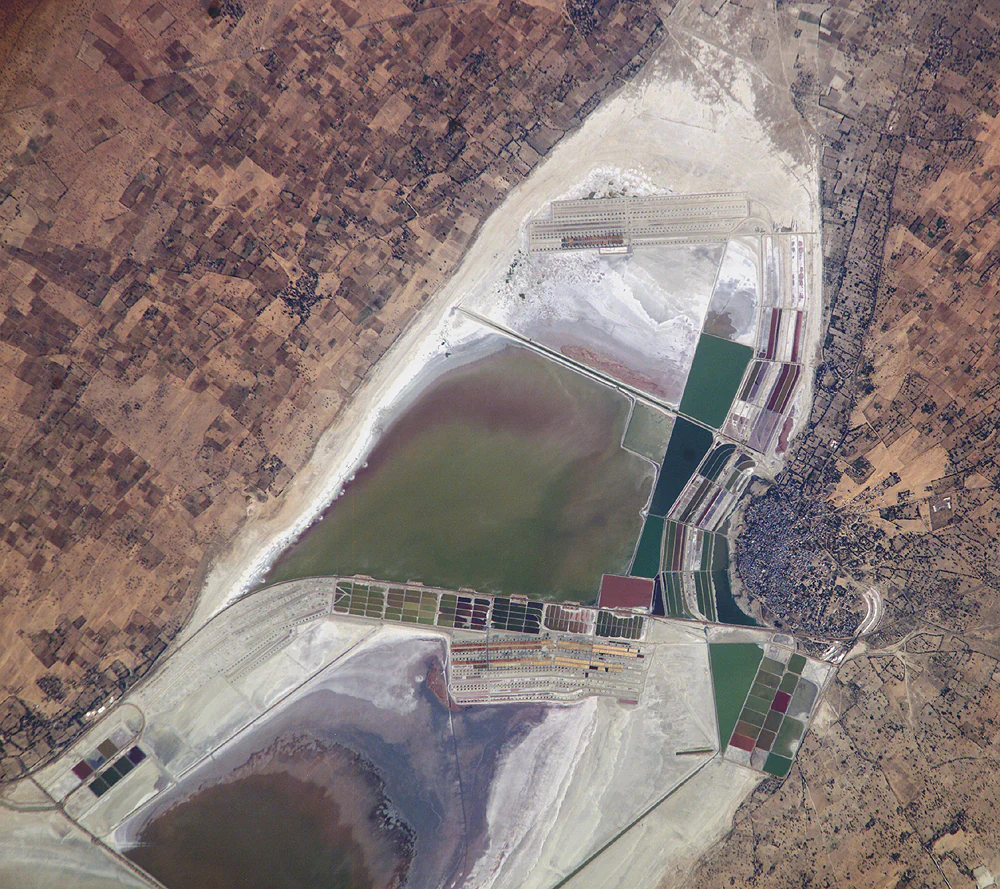
An overhead satellite image of Sambhar Salt Lake in India, displaying intricate geometric salt production ponds in shades of green, brown, and red against the surrounding arid landscape.
Satellite view of the eastern saltworks at Sambhar Salt Lake, showing the industrial infrastructure used for salt extraction.

Sambhar Salt Lake history and protected-area timeline

Human interest in the Sambhar basin stretches back many centuries. Archaeological excavations beginning in 1884 uncovered terracotta figurines, coins, seals, a clay stupa, and other small finds that suggest Buddhist cultural influence in the area, with further systematic work around 1934 producing a much larger collection of decorated discs and stoneware; many of these pieces are now held at Jaipur's Albert Hall Museum.

The lake's salt resources entered documented history under the Mughal dynasty, which administered salt production here before the lake's ownership shifted and was eventually shared between the princely states of Jaipur and Jodhpur. The British later built a railway from Sambhar Lake City to the salt works, a piece of infrastructure that still frames the eastern salt-pan landscape.

In the modern era, the lake was formally recognized as a wetland of international importance in 1990 when it became a Ramsar Site. Government salt operations have continued through Sambhar Salts Ltd., a joint venture between Hindustan Salts Limited and the state of Rajasthan, while large-scale planning proposals, including a proposed 4,000 MW ultra-mega solar project, were later withdrawn on environmental grounds. Since 2019, the state government has also pursued an asset-liability assessment aimed at restructuring the loss-making salt company.

Sambhar Salt Lake landscape and geographic character

Sambhar's physical setting is defined by a single dominant feature: a vast, shallow elliptical basin framed on all sides by the Aravali hills. The lake itself runs more than 35 kilometers along its main axis, while its narrowest stretches are only a few kilometers wide, giving it a strong linear character when viewed from above. The surrounding hills, ancient and eroded, channel incoming streams and visually enclose the basin.

The lake bed is a classic playa surface, flat and salt-encrusted across much of the dry season. During the monsoon and the weeks that follow, the basin fills into a shimmering sheet of brine whose color shifts with salinity and microbial activity from pink to deep red. A roughly 5.1 kilometer sandstone dam crosses the lake, creating a sharp boundary between the natural saline water body to the west and the engineered salt-pan landscape to the east, with its geometric reservoirs, canals, and raised ridges.

Climate adds another strong visual dimension. Summer temperatures near 45°C bake the exposed flats and drive rapid evaporation, while winter mornings near 5°C often fog the basin. Both extremes shape the lake's textures and color, from the glossy white crust of dried salt to the broad pastel washes of water and the dramatic skies typical of the Thar Desert.

Sambhar Salt Lake ecosystems, habitats, and plant life

Ecologically, Sambhar is defined by its extremes. Its salinity, often several times that of the ocean, excludes most freshwater species and leaves a narrow but specialized community of salt-tolerant algae, bacteria, and brine-dependent organisms. These microorganisms paint the water in seasonal shades of pink and red and form the base of a food web that supports enormous numbers of waterfowl.

The lake is best understood as a dynamic system rather than a stable habitat. During the dry months, much of the basin is a near-sterile salt flat; with the monsoon, brief dilution allows life to bloom, fueling invertebrates and small organisms on which flamingos and other migratory birds feed. As evaporation concentrates salts again through winter and spring, the lake slowly resets into its hypersaline state.

This pulsing pattern makes Sambhar a particularly important seasonal wetland. It functions as a staging and wintering site for tens of thousands of migratory birds whose presence tracks water depth, salinity, and the productivity of the lake's microbial communities. The surrounding dryland vegetation, including thorny scrub forest on the lower slopes of the Aravalis, supports a different but complementary set of species that move between the hills and the lake margin.

Sambhar Salt Lake wildlife and species highlights

The most iconic wildlife at Sambhar is unquestionably the flamingo. Two species visit the lake: the Greater Flamingo, the larger and paler of the pair, and the Lesser Flamingo, which arrives in significant numbers when conditions favor the algae on which it feeds. Their seasonal gatherings can run into the tens of thousands, painting the shallow margins pink and turning the lake into one of India's most recognizable bird scenes.

Beyond flamingos, the lake attracts a wide array of migratory waterfowl that use Sambhar as a winter feeding and resting ground. The diversity and abundance of these visitors depends heavily on water levels and salinity, with good monsoon rains often translating into the most vibrant bird seasons. The surrounding scrub forest and arable land support more typical dryland species, including nilgai, several kinds of deer, and foxes, which range through the Aravali foothills close to the basin.

Sambhar's wildlife value has been recognized internationally through its Ramsar designation, but it also illustrates how vulnerable such systems can be. The lake experienced catastrophic bird mortality events linked to avian botulism in 2019, when more than 18,000 birds died, and again in 2024. Studies suggest declining flamingo nesting and reductions in recorded migratory species over recent decades, linked to habitat stress and hydrological disruption.

Sambhar Salt Lake conservation status and protection priorities

Sambhar Salt Lake's principal conservation credential is its designation as a Ramsar wetland in 1990, recognizing it as a wetland of international importance under the Ramsar Convention. The recognition reflected the lake's specific hydrology, its specialized microbial and algal communities, and its exceptional importance for migratory waterfowl, particularly Greater and Lesser Flamingos.

In recent years, however, conservation attention has shifted heavily toward the lake's vulnerabilities rather than its strengths. Illegal extraction has been a central concern: thousands of unauthorized borewells around the basin have lowered groundwater by tens of meters, while illegal salt pans and encroachments have shrunk the functional wetland. Independent reporting and satellite-based studies point to a steady loss of wetland area, with documented declines in migratory bird species richness, falling flamingo arrival numbers, and shrinking nesting.

Regulatory responses have intensified but have so far struggled to keep pace with the pressures. The National Green Tribunal has ordered the cancellation of illegal salt pans and pushed for stronger environmental oversight; public-interest litigation has sought to address borewell-driven groundwater depletion; and salt supply from the lake was temporarily suspended after major die-offs. Sustained multi-agency action, combining habitat monitoring, stricter extraction controls, removal of bird carcasses during outbreaks, and broader wetland restoration, has been increasingly framed as essential to the lake's survival.

Sambhar Salt Lake cultural meaning and human context

Sambhar's cultural importance is unusually rich for a saline lake. The Indian epic Mahabharata and later Puranic literature refer to the area around Sambhar as the capital of the demon king Vrishparva, and to its priest Shukracharya, whose daughter Devayani is said to have married the emperor Yayati. A temple near the lake remains dedicated to Devayani, tying these epic associations to the present landscape.

The lake also carries strong associations with the goddess Shakambhari, a form of Durga and tutelary deity of the Chauhan Rajputs, including Prithviraj Chauhan. One tradition credits her with transforming a forest into a plain of silver; another describes her turning precious jewels into salt to prevent conflict among the townspeople. From this the lake's name, a variant of Shakambhari, took root in legend around the sixth century.

Local industry and identity have long revolved around salt. Mughal-era administration of the salt works, later princely-state oversight, and the modern Sambhar Salts Ltd. operation all reflect the way Sambhar Salt Lake has shaped livelihoods, trade, and the cultural identity of the surrounding villages. The town of Sambhar itself, encircled by the lake, expresses this long entanglement between people and the salt flats.

Top sights and standout views in Sambhar Salt Lake

Sambhar Salt Lake's standout qualities revolve around scale, salinity, and seasonal spectacle. It is India's largest inland salt lake and the biggest playa in the Thar Desert, an ephemeral basin whose size and color shift dramatically with the monsoon.

Equally distinctive is the lake's industrial heritage: eastward of the central sandstone dam lies a 80 square kilometer mosaic of historic evaporation ponds, canals, and pans where salt has been harvested for at least a thousand years. To the west sits the natural hypersaline water body, three to four times saltier than sea water and host to seasonal blooms of pink algae.

The lake's most memorable highlight, however, is ecological. Tens of thousands of Greater and Lesser Flamingos, alongside other migratory waterfowl, transform the margins of the lake into one of India's most vivid bird gatherings each winter, even as ongoing conservation challenges make each season a reminder of how fragile this setting has become.

Best time to visit Sambhar Salt Lake

The character of a visit to Sambhar Salt Lake shifts profoundly with the monsoon cycle. The rainy season, broadly from July into early autumn, dilutes the lake's salinity and fuels algal and microbial blooms, which in turn draw large numbers of migratory waterfowl. By late autumn and winter, flamingo numbers typically peak, water levels remain favorable, and cooler temperatures around the basin make birding and sightseeing comfortable.

Late winter and early spring still offer rich birdlife and dramatic salt-pan scenery, though as evaporation intensifies, much of the lake may revert to a bright white salt crust and access to certain areas can become more limited. Avoid planning around the peak of summer, when temperatures near 45°C make the open flats harsh and wildlife viewing is poor. Dry-season visits are best treated as scenic visits to the salt-pan landscape rather than wildlife-focused trips.
Monthly climate preview

Long-term representative monthly temperature and precipitation data patterns

Sambhar Salt Lake Climate Normals and Annual Temperature Rhythm

Sambhar Salt Lake experiences significant annual temperature shifts alongside distinct precipitation variations across recorded coordinates. Examining the complete twelve-month climate profile provides detailed historical metrics for structured meteorological analysis.
Annual mean26 °C
15 °C35 °C
Jan15°
Feb18°
Mar24°
Apr30°
May34°
Jun35°
Jul31°
Aug29°
Sep28°
Oct26°
Nov21°
Dec16°
Warmest month
June

34.6 °C

Coolest month
January

14.5 °C

Wettest month
July

4.9 mm/day

Driest month
December

0.1 mm/day

Park location guide

Geography guide, regional context, and park location map for Sambhar Salt Lake

Sambhar Salt Lake park geography, regions, and map view in India

Understand where Sambhar Salt Lake sits in India through a broader geographic reading of the surrounding landscape, nearby location context, and its mapped position within the national park landscape.

How Sambhar Salt Lake fits into India

India is a South Asian country bordered by the Indian Ocean, Arabian Sea, and Bay of Bengal. It shares land borders with Pakistan, China, Nepal, Bhutan, Bangladesh, and Myanmar. The country has a population of over 1.4 billion people and operates as a federal parliamentary republic with its capital in New Delhi.

Wider geography shaping Sambhar Salt Lake in India

India occupies the Indian subcontinent in South Asia, bordered by the Arabian Sea to the southwest, the Bay of Bengal to the southeast, and the Indian Ocean to the south. It shares land borders with Pakistan to the west, China, Nepal, and Bhutan to the north, and Bangladesh and Myanmar to the east. The territory also includes the Andaman and Nicobar Islands in the Indian Ocean.

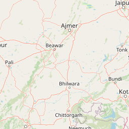
Map view of Sambhar Salt Lake

Use this park location map to pinpoint Sambhar Salt Lake in India, understand its exact geographic position, and read its mapped placement within the surrounding landscape more clearly.

Pigeon | © OpenStreetMap contributors

Visual exploration of saline flats, seasonal water bodies, and wetland habitats.

Sambhar Salt Lake Photos and Landscape Scenery

Visual records document the expansive salt pans, ephemeral brine basins, and desert fringe environments defining Sambhar Salt Lake. Photographic documentation reveals the shifting colors of the playa floor, seasonal flamingo gatherings, and arid mountain backdrops.

An overhead satellite image of Sambhar Salt Lake in India, displaying intricate geometric salt production ponds in shades of green, brown, and red against the surrounding arid landscape.

An aerial satellite view of Sambhar Salt Lake showing white salt flats and deep red evaporation ponds surrounded by arid brown land.

Park atlas

Compare adjacent wetland habitats and regional protected areas across the arid basin

Exploring Parks Near Sambhar Salt Lake and Surrounding Protected Landscapes

Continue geographic comparison by discovering other national parks and protected areas located near Sambhar Salt Lake. Evaluating adjacent regional ecosystems helps map the wider ecological context of the surrounding terrain.
National parkRajasthan
About 165 km away#1 closest

Southeast

Ranthambore National Park: Protected Area Atlas and Dry Deciduous Landscape Exploration

Discover its unique terrain and mapped boundaries.

Dive into the protected landscape of Ranthambore National Park, a nationally significant protected area in Rajasthan, India. This page offers detailed insights into its dry deciduous forest ecosystem, characterized by rocky hills, open grasslands, and vital lakes. Explore the park's mapped boundaries and understand its position within the regional geography, providing an atlas-centric view of its terrain and conservation importance.

Area
1,334 km²
Established
1980
IUCN
II
Relief
Mixed relief
Wildlife reserveHaryana
About 228 km away#2 closest

Northeast

Bhindawas Wildlife Sanctuary: Protected Wetland Mapping and Regional Landscape Context

A key Ramsar site within the Sahibi River ecological corridor of Haryana

Examine the geographic footprint of Bhindawas Wildlife Sanctuary, a significant 412-hectare wetland in Haryana. This protected area supports dense migratory waterbird populations by maintaining a stable aquatic environment through an engineered network of canals and natural rainfall. The sanctuary stands as an essential component of the regional forest and wetland chain linking the Aravalli hills to the Yamuna floodplain.

Area
4.12 km²
Established
1986
IUCN
IV
Relief
Lowland
Watercolor illustration of a wetland landscape with grasses, trees, and a sunset
National parkIndia
About 241 km away#3 closest

East

Keoladeo National Park: India's Renowned Wetland Bird Sanctuary and Protected Landscape

Explore its mapped terrain and critical avian habitat near Bharatpur.

Keoladeo National Park, a designated national park in India, represents a critical hub for wetland conservation and avian biodiversity. The park's meticulously managed wetland system, a mosaic of shallow waters and grasslands, provides essential habitat for thousands of resident and migratory birds from across Eurasia. Situated near Bharatpur, this protected landscape offers a unique opportunity to study the intersection of arid and fertile plains geography and serves as a vital stopover point on major bird flyways, underscoring its importance in regional conservation efforts.

Area
28.7 km²
Established
1982
IUCN
II
Visitors
147K annual
National parkRajasthan
About 243 km away#4 closest

South

Mukundara Hills National Park: Rajasthan's Protected Landscape for Tigers and Diverse Habitats

Explore its dry deciduous forests, rocky hills, and riverine ecosystems.

Mukundara Hills National Park is a significant national park and tiger conservation landscape situated in eastern Rajasthan, India. This protected area features a varied terrain encompassing rocky hills, dry deciduous forests, and crucial grassland patches, all intersected by major rivers like the Chambal. Its ecological importance lies in providing vital habitat for Bengal tigers and a mosaic of landscapes that support a wide array of wildlife. Understanding its mapped boundaries and geographic context reveals its critical role in regional conservation efforts and provides a rich atlas-level view of protected lands in western India.

Area
759.99 km²
Established
2004
IUCN
II
Relief
Mountain
National parkHaryana
About 245 km away#5 closest

Northeast

Sultanpur National Park: Haryana's Designated Protected Landscape and Atlas Context

Mapped boundaries and regional geographic significance.

Delve into Sultanpur National Park, an important protected area within Haryana, India, viewed through an atlas and map-driven lens. This entry details the park's designation as a national park, offering insights into its specific geographic footprint and its relation to the surrounding regional terrain. Understand how Sultanpur National Park contributes to the protected landscape mosaic of North India, providing critical data for those exploring India's geography and conservation areas.

Area
1.43 km²
Established
1991
IUCN
II
Relief
Lowland
National parkMadhya Pradesh
About 252 km away#6 closest

Southeast

Kuno National Park: Madhya Pradesh National Park Atlas and Protected Landscape

Explore its diverse dry deciduous forests and savannah terrain.

Kuno National Park is a protected area in Madhya Pradesh, India, renowned for its dry deciduous forest and savannah grassland ecosystems. This national park, bisected by the Kuno River, offers a significant landscape for understanding regional geography and conservation efforts within India. Its varied terrain provides essential habitat and contributes to the broader atlas of protected lands, making it a key destination for geographic discovery.

Area
748.76 km²
Established
2018
IUCN
II
Relief
Lowland
Wildlife reserveUttar Pradesh
About 275 km away#7 closest

East

Sur Sarovar Wildlife Reserve: A Protected Wetland Sanctuary in Uttar Pradesh

Mapped freshwater landscapes and migratory bird habitats.

Sur Sarovar serves as a significant wildlife reserve in Uttar Pradesh, characterized by the distinct geometric shape of Keetham Lake. This protected wetland provides essential breeding habitat for diverse waterbird species across its shallow margins and islands. The area also hosts a vital sloth bear rescue center, anchoring its status as a key site for wildlife rehabilitation and conservation efforts within the broader Gangetic plains region.

Area
7.13 km²
Established
1991
Water
Water-dominated
National parkMadhya Pradesh
About 317 km away#8 closest

Southeast

Madhav National Park: National Park Atlas and Protected Landscape Identity

Mapping the geography and protected boundaries of Madhav National Park.

Delve into the detailed geographic profile of Madhav National Park, a vital national park situated in Madhya Pradesh, India. This section offers an atlas-centric perspective, highlighting the park's protected landscape characteristics and its precise location within the regional geography. Uncover its mapped boundaries and understand its role as a key protected area for comprehensive geographic exploration.

Area
354 km²
Established
1956
IUCN
II
Visitors
500 annual

Common questions about visiting, size, designation, and location context for Sambhar Salt Lake

Sambhar Salt Lake FAQs for park facts, access, geography, and protected area context

Find quick answers about Sambhar Salt Lake, including protected-area facts, park geography, trail and visitor context, and how the park fits into its surrounding country and regional landscape.
MoriAtlas Explorer

Continue Your Protected Areas Search Across the Global Atlas

Deepen your exploration by continuing the structured search for national parks and protected areas worldwide. Utilize the comprehensive filtering capabilities to compare different conservation landscapes and refine your understanding of global park geography. Discover more about the distribution and characteristics of protected natural areas.

Global natural geography