
Lakes
Park geography
A comprehensive analysis of mountain landscape characteristics, elevation zones and regional extent.
Sierra Nevada National Park: Detailed Geographic Profile, Terrain and Mapped Boundaries
Examine the technical geographic footprint of Sierra Nevada National Park, located across Andalusia and Almería in Spain. This structured profile details the 858.83 square kilometer area, the 3479 meter maximum elevation, and the diverse network of mountain streams, alpine meadows, and Mediterranean ecosystems that define the protected landscape.
Spain's highest mountain range protecting Europe's southernmost alpine ecosystems
Sierra Nevada National Park
Sierra Nevada National Park protects the highest mountain range in mainland Spain, spanning the provinces of Granada and Almería in the autonomous community of Andalusia. Declared a national park in January 1999, it encompasses over 85,000 hectares of dramatic alpine landscapes featuring more than twenty peaks exceeding 3,000 meters, including Mulhacén, the highest point on the Iberian Peninsula at 3,479 meters. The park sits at the southernmost edge of continental Europe, creating a unique ecological island where species survived the Ice Age by migrating south and then persisting in these high-altitude refugia. This geographic isolation has produced an extraordinary concentration of endemic species, with over sixty plants found nowhere else on Earth. The landscape displays classic glacial features including U-shaped valleys, moraines, and nearly fifty high-mountain lakes, while the range serves as a critical watershed feeding both the Atlantic-bound Guadalquivir basin and rivers flowing to the Mediterranean.
- Location
- Spain
- Park type
- National park
- Established
- 1999
- Area
- 858.8 km²
- Highest point
- 3,479 m
Location overview
Regional distribution within Andalusia and Almeria, Spain
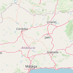
Geographic Position of Sierra Nevada National Park in Spain
Sierra Nevada National Park is situated within the regions of Andalusia and Almeria in southern Spain. As a single-country, mainland protected area, it is not categorized as a transboundary, coastal, marine, or island park.
- Countries
- Spain
- Regions
- Almería, Andalusia
- Primary location
- Andalusia
- Geographic setting
- Inland
Boundary and coordinates
Interactive boundary geometry and calculated spatial measurements
Sierra Nevada National Park Boundary Map and Geographic Extent
Mapped park outlines provide clear spatial context for analyzing protected territorial limits. Accompanying facts detail total recorded area measurements, coordinate spans, and geographic center points.
- Boundary area
- 858.9 km²
- Boundary perimeter
- 433.9 km
- Northernmost point
- 37.2112° N
- Southernmost point
- 36.9407° N
- Easternmost point
- 2.6638° W
- Westernmost point
- 3.5475° W
- Geographic centre
- 37.0724° N, 3.2067° W
- North–south span
- 30 km
- East–west span
- 78.6 km
Elevation and terrain
Mountain relief peaks up to 3479 meters across protected terrain
Sierra Nevada National Park Elevation and Terrain Summary
Recorded park elevation details outline the maximum height reaching 3479 meters across mountain terrain. Associated natural feature cards display names, types, and spatial relationships found within boundaries.
- Maximum elevation
- 3,479 m
- Highest point
- 3,479 m
Selected named natural features
Peaks
Tajo de los Machos Norte
3,071 m
Streams
Río del Pueblo
Peaks
Peñón de la Loma
1,884 m
Natural springs
Borreguil de la Umbría
Peaks
Cerro de los Frailecillos
1,898 m
Environmental setting
Interpreting Mediterranean climate zones, mountain relief, and habitat types across stored records
Sierra Nevada National Park Environmental Setting and Physical Geography Classifications
Recorded landscape features, montane forests, and water presence combine to form complementary interpretations of the park physical setting. Connected categories link directly to relevant atlas destinations for structured geographic navigation.
- Relief
- Mountain
- Climate
- Mediterranean
- Water
- Major water bodies
- Forest cover
- Partial forest
- Seasonality
- Seasonal
Landscape features
Mountains · Valleys · Lakes · Rivers · Glacier
Habitat types
Montane forest · Alpine meadow · Grassland · Wetland
Park atlas
Explore connected landscapes and compare protected areas across the dramatic high-mountain geography of Southern Spain.
Discover More Parks and Protected Areas Near Sierra Nevada National Park, Spain's Alpine Heart
Broaden your geographic exploration from Sierra Nevada National Park by discovering other high-altitude protected areas and unique Mediterranean-Alpine landscapes across Spain's southern region. Compare distinct glacial features, trace how surrounding conservation landscapes connect, and deepen your understanding of regional park geography through an atlas-style view.
Nature reserveAndalusia
35 km away#1 closest
Southwest

Acantilados de Maro-Cerro Gordo: Protected Coastal Cliffs and Marine Geography Atlas
Mapping the rugged Mediterranean boundary in Andalusia, Spain
Discover the complex geography of Acantilados de Maro-Cerro Gordo, a protected nature reserve defined by vertical cliffs exceeding 200 meters and isolated coastal coves. This atlas entry details the transition between Betic mountain terrain and marine ecosystems, documenting prominent headlands like Cerro Gordo and the biological richness of its protected reefs and seagrass meadows.
- Area
- 19.129 km²
- Established
- 1989
- Relief
- Upland
- Climate
- Mediterranean
National parkSpain
126 km away#2 closest
West
Sierra de las Nieves National Park: Ancient Fir Forests and Karst Geography in Andalusia
Mapped protected landscape and unique geologic features
Sierra de las Nieves National Park stands as a remarkable protected area in Andalusia, Spain, celebrated for its world-leading Spanish fir forests and intricate karst topography. This national park showcases significant geological diversity, from towering limestone formations and deep caves to the striking red peridotite mountains of Sierra Bermeja. Its elevation, reaching Pico Torrecilla at 1,919 meters, offers a unique alpine landscape context within southern Europe, mapped for detailed geographic discovery and protected area exploration.
- Area
- 939.3 km²
- Established
- 1989
- IUCN
- II
- Visitors
- 100K annual
National parkMorocco
About 204 km away#3 closest
South

Al Hoceima National Park: Morocco's Coastal and Marine Protected Wilderness
Explore dramatic cliffs, kelp forests, and marine biodiversity.
Al Hoceima National Park represents a significant protected coastal and marine area in northern Morocco, distinguished by its rugged 50-kilometer Mediterranean coastline featuring spectacular limestone cliffs. This national park offers an atlas-style view of a landscape transitioning from the Ibaqouyen Rif mountains to the sea, harboring rich marine biodiversity including significant osprey colonies and dolphin habitats. Discover the mapped extent of this wild protected territory and its unique ecological features.
- Area
- 480 km²
- Established
- 2004
- IUCN
- II
- Relief
- Mountain
National parkSpain
215 km away#4 closest
North
Tablas de Daimiel National Park: Spain's Inland Wetland National Park and Protected Area
Explore mapped boundaries and regional geographic context.
Tablas de Daimiel National Park represents one of the last remaining examples of floodplain wetland systems in Spain's interior. Located in Castilla-La Mancha, this protected area showcases a unique confluence of fresh and brackish waters, supporting a rich mosaic of emergent vegetation and serving as a critical habitat for migratory birds. Use MoriAtlas to explore its precise geographic setting, mapped terrain, and its role as a vital conservation landscape within the Iberian Peninsula.
- Area
- 30.3 km²
- Established
- 1973
- IUCN
- II
- Relief
- Lowland
National parkHuelva
241 km away#5 closest
West
Doñana National Park National Park: Mapped Geography and Protected Landscape Context
Explore Huelva's key protected area and its regional geographic setting.
Delve into the structured geographic data and mapped boundaries of Doñana National Park. This entry highlights its identity as a national park within the Huelva region, providing essential context for understanding its protected landscape. MoriAtlas offers this detail to facilitate a clear, atlas-driven exploration of its natural terrain and its place in the broader geographic framework of Spain.
- Area
- 543 km²
- Established
- 1969
- IUCN
- II
- Visitors
- 376.3K annual
National parkMorocco
About 249 km away#6 closest
Southwest
Talassemtane National Park: Morocco's Premier Protected Landscape and Geographic Atlas Entry
Explore its mapped boundaries and natural terrain.
Talassemtane National Park is a vital protected area contributing to the geographic diversity of Morocco. This entry focuses on its identity as a national park, detailing its mapped boundaries and providing context within the broader atlas of protected lands. Discover the specific geographic and landscape characteristics that define this Moroccan national park, offering a unique lens for regional exploration.
- Area
- 589.5 km²
- Established
- 2004
- IUCN
- II
- Relief
- Mountain
National parkToledo Province
249 km away#7 closest
Northwest
Cabañeros National Park: Spain's Premier Iberian Oak Woodland Protected Landscape
Mapped Geography of Montes de Toledo Protected Area
Cabañeros National Park is celebrated as the most extensive and well-conserved example of Iberian Mediterranean forest in Spain. Situated within the Montes de Toledo, the park features a remarkable dichotomy between its unique raña flatlands and mountainous sierras, harboring ancient oak woodlands and significant biodiversity. This national park serves as a crucial component of the region's geographic context and a prime destination for atlas-based discovery of protected landscapes.
- Area
- 409 km²
- Established
- 1995
- IUCN
- II
- Visitors
- 104.6K annual
Biosphere reserveExtremadura
About 267 km away#8 closest
Northwest
La Siberia Biosphere Reserve: Mapped Geography and Protected Lands of Extremadura
A study of reservoir coastlines and Mediterranean serranías
La Siberia Biosphere Reserve offers a deep look into the rural landscape of Extremadura, Spain. Characterized by five major reservoirs and vast Mediterranean oak dehesas, the area provides essential habitat for raptors and preserves significant prehistoric rock art within its complex serranía topography. Explore the geographic boundaries and water-dominated landscape of this distinct inland region.
- Area
- 2,836.7 km²
- Established
- 2019
- Relief
- Mountain
- Climate
- Mediterranean
MoriAtlas Explorer
Continue Your Atlas Exploration of Sierra Nevada National Park's Unique Alpine Geography
Delve deeper into the mapped terrain and protected landscape of Sierra Nevada National Park. Understanding its position within Andalusia and its role as a high-altitude refuge for endemic species provides crucial geographic context. Use MoriAtlas to navigate the park's mapped boundaries and appreciate its significant contribution to continental Europe's high mountain ecosystems.
Browse next
Global natural geography
Explore related park routes
Explore MoriAtlas Global ParksBrowse All MoriAtlas ParksGlobal Park Map DiscoveryMoriAtlas: Browse All CountriesBrowse All MoriAtlas ContinentsNational Park Environment AtlasGrand Canyon National Park AtlasYellowstone National Park AtlasYosemite National Park Atlas and GeographySerengeti National Park AtlasGalápagos National Park Protected LandscapeBanff National Park Geography and AtlasKruger National Park Atlas EntryUluṟu-Kata Tjuṯa National Park AtlasExplore Uluru-Kata Tjuta National Park GeographyPlitvice Lakes National Park AtlasFiordland National Park Protected LandscapeGreat Smoky Mountains National Park AtlasAfghanistan National Parks and Protected AreasAlbania National Parks and Protected AreasAlgeria National Parks and Protected AreasAmerican Samoa National Parks and Protected AreasAndorra National Parks and Protected AreasAngola National Parks and Protected AreasAntarctica National Parks and Protected AreasAntigua and Barbuda Park List