


Mori Atlas logo
Marine protected areaSipadan Island Park

Geographic analysis of underwater terrain, reef boundaries, and the isolated volcanic landscape of this Celebes Sea sanctuary.

Sipadan Island Park Marine Protected Area: Mapping the Volcanic Seamounts and Coral Reefs of Sabah

Sipadan Island Park represents a significant marine protected area in the Celebes Sea, defined by its unique status as a limestone-topped volcanic seamount rising 600 metres from the seafloor. This canonical map-based record examines the diverse underwater topography, including near-vertical coral walls, extensive reef flats, and the intricate limestone cave systems that define the park's structural character. Visitors and researchers can trace the extent of the protected waters off the coast of Sabah, analyzing the intersection of isolated oceanic geography and the dense marine ecosystems thriving within the Indo-Pacific basin.

marine parkoceanic islandscuba divingcoral reefcelebes seasabah
A flat vector illustration showing a small tropical island surrounded by water, with a tall wooden lookout tower standing among trees and palm trees, set against a background of soft hills.

Sipadan Island Park

Marine protected area

Park overview

Structured park overview, official facts, and landscape profile for Sipadan Island Park

Sipadan Island Park park facts, protected area profile, and essential visitor context

Review the core facts for Sipadan Island Park, including designation, size, terrain, visitor scale, habitats, and operating context in one park-focused overview.

About Sipadan Island Park

Sipadan Island Park is a marine protected area that extends well beyond the small island of Sipadan itself, covering a broad sweep of reef, slope, and open ocean in the Celebes Sea off the Semporna coast of Sabah, in Malaysian Borneo. At the centre of the park is Sipadan, a small but ecologically outsized island that has become one of the most celebrated dive destinations on the planet. The park is administered by Sabah Parks, the agency responsible for several of Sabah's major terrestrial and marine protected areas, and operates under increasingly strict access and conservation rules designed to limit the cumulative impact of diving tourism.

The island's geology is fundamental to what the park protects. Sipadan sits atop an extinct volcanic cone buried deep beneath the Celebes Sea, and thousands of years of coral growth have built the present reef structure on this submerged foundation. Because the cone rises almost vertically from the deep seafloor, the surrounding reef environment includes sheer drop-offs, plunging walls, and a mosaic of reef flats, gutters, caves, and pelagic zones within a relatively compact area. This dramatic underwater topography, combined with the park's position at the heart of the Indo-Pacific basin, creates habitats that concentrate both resident reef life and visiting pelagic species.

Today, Sipadan Island Park is recognised globally as a benchmark for marine-protected-area management in a heavily used dive setting. Visitors must hold a Sabah Parks permit to enter the waters around the island, daily permit numbers are tightly controlled, and dive marshals monitor underwater activity. All resort facilities that previously operated on Sipadan itself were closed in 2004 to remove localised pressure on the reef, shifting accommodation and surface activity to nearby Mabul Island. The park continues to serve as both a working example of managed marine tourism and a refuge for some of the richest reef biodiversity in the Coral Triangle.

Quick facts and research context for Sipadan Island Park

Sipadan Island Park is a marine park in the Celebes Sea, administered by Sabah Parks and covering 16,860 hectares around Sipadan Island. Sipadan itself is Malaysia's only oceanic island, formed from living corals growing on an extinct volcanic cone that rises around 600 metres from the seabed. The island lies within the Indo-Pacific basin, a region widely regarded as the heart of global marine biodiversity. The park has its roots in a 1933 bird sanctuary declaration by the colonial government of North Borneo, was re-gazetted after Malaysia's formation, and received formal marine park status in 2004.

Protection and recognition

Documented marine protection scope, designation year, and recognition sources

Sipadan Island Park Protection Status and Designation History

Sipadan Island Park holds a documented marine protection scope established in the year 2004. Structured records outline the formal designation history and management framework associated with the protected area.

Protection details

Protection scope
Marine
Designated year
2004
Transboundary protection
No
Park context

Deeper park guide and search-rich context for Sipadan Island Park

Sipadan Island Park history, landscape, wildlife, and travel context

Explore Sipadan Island Park through its history, landscape character, ecosystems, wildlife, conservation priorities, cultural context, and seasonal travel timing in a structured park guide built for atlas discovery and search intent.

Why Sipadan Island Park stands out

Sipadan is best known worldwide for its extraordinary coral walls, dramatic drop-offs, and dense concentrations of marine life, particularly its large schools of barracuda forming tornado-like shapes, gatherings of big-eye trevally and bumphead parrotfish, and regular encounters with green and hawksbill sea turtles that come ashore to nest. The island is also recognised for encounters with pelagic visitors such as manta rays, eagle rays, scalloped hammerhead sharks, and occasional whale sharks and even killer whales. The underwater limestone cave system known as the Turtle Tomb, with its labyrinth of tunnels containing the skeletal remains of lost turtles, is one of the most iconic features in the park.
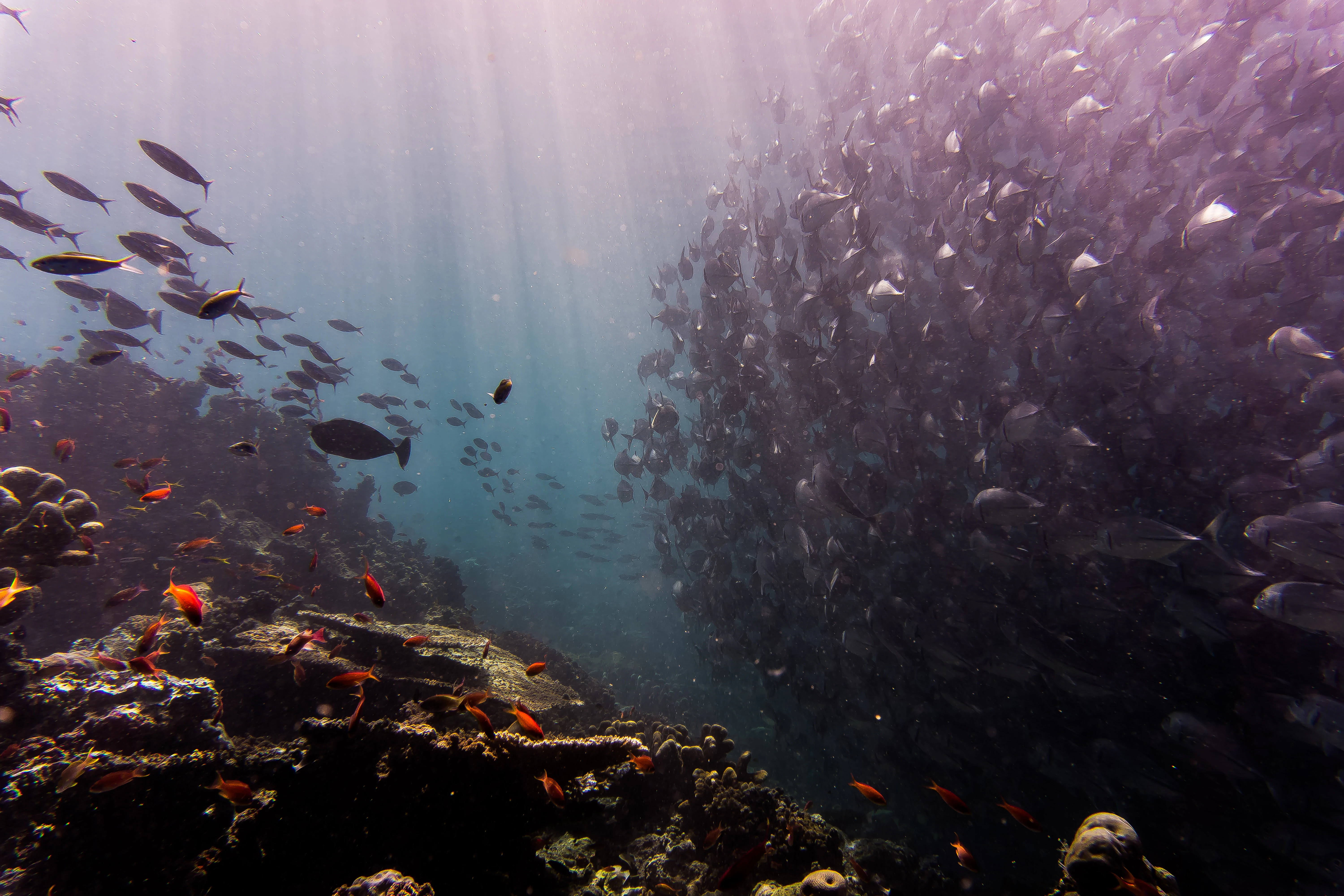
An underwater view showing a massive school of fish on the right and a coral reef on the left, with shafts of light filtering down through the water.
A large school of fish swimming through the coral reef ecosystems of Sipadan Island.

Sipadan Island Park history and protected-area timeline

Sipadan was first given formal environmental protection in 1933, when the colonial government of North Borneo declared the island a bird sanctuary. After the formation of Malaysia, the sanctuary was re-gazetted in 1963, establishing a continuous protective status for the island through the transition from colonial to independent administration.

In the latter half of the twentieth century, Sipadan gained an entirely new profile through recreational diving. During the 1980s, the coral reefs of Sipadan and nearby Mabul Island began to attract international attention as dive destinations, and the first resort on Sipadan opened in 1984. The island's global reputation was further cemented when Jacques Cousteau featured it in the 1989 film 'Borneo: The Ghost of the Sea Turtle', describing it as a place reminiscent of reefs he had seen decades earlier but which had since degraded elsewhere.

The contemporary history of the park is shaped by two intersecting stories: a territorial dispute and a conservation transformation. Sipadan was at the centre of a long-running sovereignty disagreement between Malaysia and Indonesia; in 2002, the International Court of Justice awarded the island, together with Ligitan, to Malaysia, based on the effective occupation shown by the United Kingdom as the former colonial power. Separately, in 2004 Sabah Parks declared the surrounding waters a marine park under its management, and authorities closed the six resort facilities then operating on Sipadan itself, ending on-island accommodation and reframing the site primarily as a regulated dive destination.

In 2000, Sipadan was the site of a high-profile kidnapping by the Abu Sayyaf group, in which twenty-one people, tourists and resort workers, were taken from the island to Jolo. In the aftermath, management of the island and Ligitan was placed under Malaysia's National Security Council. Subsequent expansion of the protected area in 2015 enlarged the marine park substantially, and in 2019 the Malaysian prime minister agreed in principle to return administration of both islands to the Sabah state government under Sabah Tourism, Culture and Environment. Conservation actions continue to evolve, including a one-month closure of the island in November 2023 intended to support ecosystem recovery.

Sipadan Island Park landscape and geographic character

Sipadan Island Park is defined by a dramatic underwater landscape rather than a terrestrial one. Sipadan is a small tropical island covered largely by coastal forest, but the defining topography lies beneath the sea. The island sits atop an extinct volcanic cone that rises some 600 metres from the Celebes Sea floor, and the reefs that surround it climb the sides of this cone in the form of near-vertical walls, terraces, and drop-offs. The result is an underwater terrain of unusual relief, where deep blue water often lies only a short swim from shallow reef flats fringed by white sand.

Above water, Sipadan presents the classic profile of a small oceanic island: a compact landmass ringed by beaches, with interior vegetation dominated by coastal trees and a gently uneven terrain that reflects the island's coral limestone origins. There are no roads, large settlements, or significant development on Sipadan itself, although nearby Mabul Island, situated just off the park, hosts the dive resorts and surface infrastructure now associated with visits to the area.

The broader park territory extends well beyond the island's shoreline, covering reefs, slopes, and pelagic waters across 16,860 hectares of the Celebes Sea. Numerous named dive sites within this area, including Barracuda Point, South Point, North Point, West Ridge, and the Hanging Gardens, correspond to distinctive features of this submerged landscape: coral gardens on shallow plateaus, plunging walls, and prominent ridges that interrupt the descent into deep water. The combination of an isolated oceanic setting, clear water, and varied underwater topography is what gives Sipadan Island Park its distinctive scenic character.
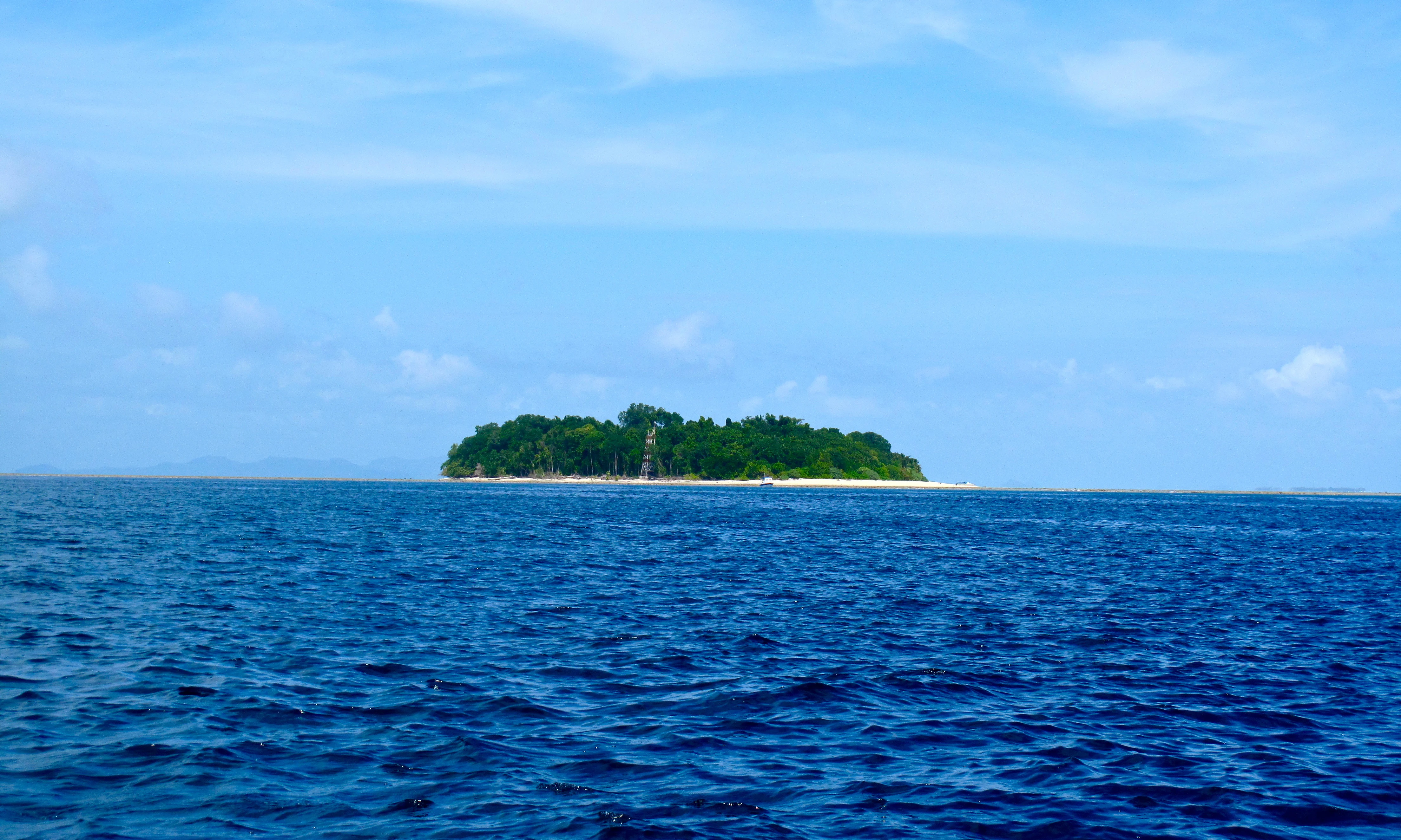
A small, tree-covered tropical island sits in the middle of a calm, deep blue sea under a light blue sky with faint clouds.
A distant view of the forested island of Sipadan, surrounded by deep blue ocean.

Sipadan Island Park ecosystems, habitats, and plant life

The natural environment of Sipadan Island Park is overwhelmingly marine, built around the coral reef ecosystems that grow on the flanks of the submerged volcanic cone beneath Sipadan and across the surrounding Celebes Sea. Hundreds of species of coral have been documented in this ecosystem, forming a complex mosaic of reef habitats that range from gently sloping garden zones near the surface to steep walls and overhangs where hard and soft corals thrive in dimmer conditions. The structural diversity of the reef: caverns, swim-throughs, ledges, and caves, is what underpins the park's exceptional biological richness.

Because Sipadan sits squarely within the Indo-Pacific basin, often described as the global centre of marine biodiversity, its reefs include many of the region's signature coral genera and contribute to the wider Coral Triangle's reputation as a priority area for reef conservation. Above the reef itself, pelagic waters around the island support a different dimension of marine life, with open-ocean species regularly moving through the channels and drop-offs where deep water approaches the reef edge. This vertical layering, from coral gardens to pelagic zone, gives the park an unusually broad ecological profile for a single-site marine protected area.

While the park is best known for its marine ecosystems, the island itself also carries a small terrestrial component, with coastal forest and a history as a bird sanctuary dating to 1933. Seabirds and shorebirds continue to use the island, and the combination of forest cover, beaches, and surrounding reef means that the park supports ecological processes both on land and at sea, though its identity as a protected natural area is dominated by its underwater habitats.
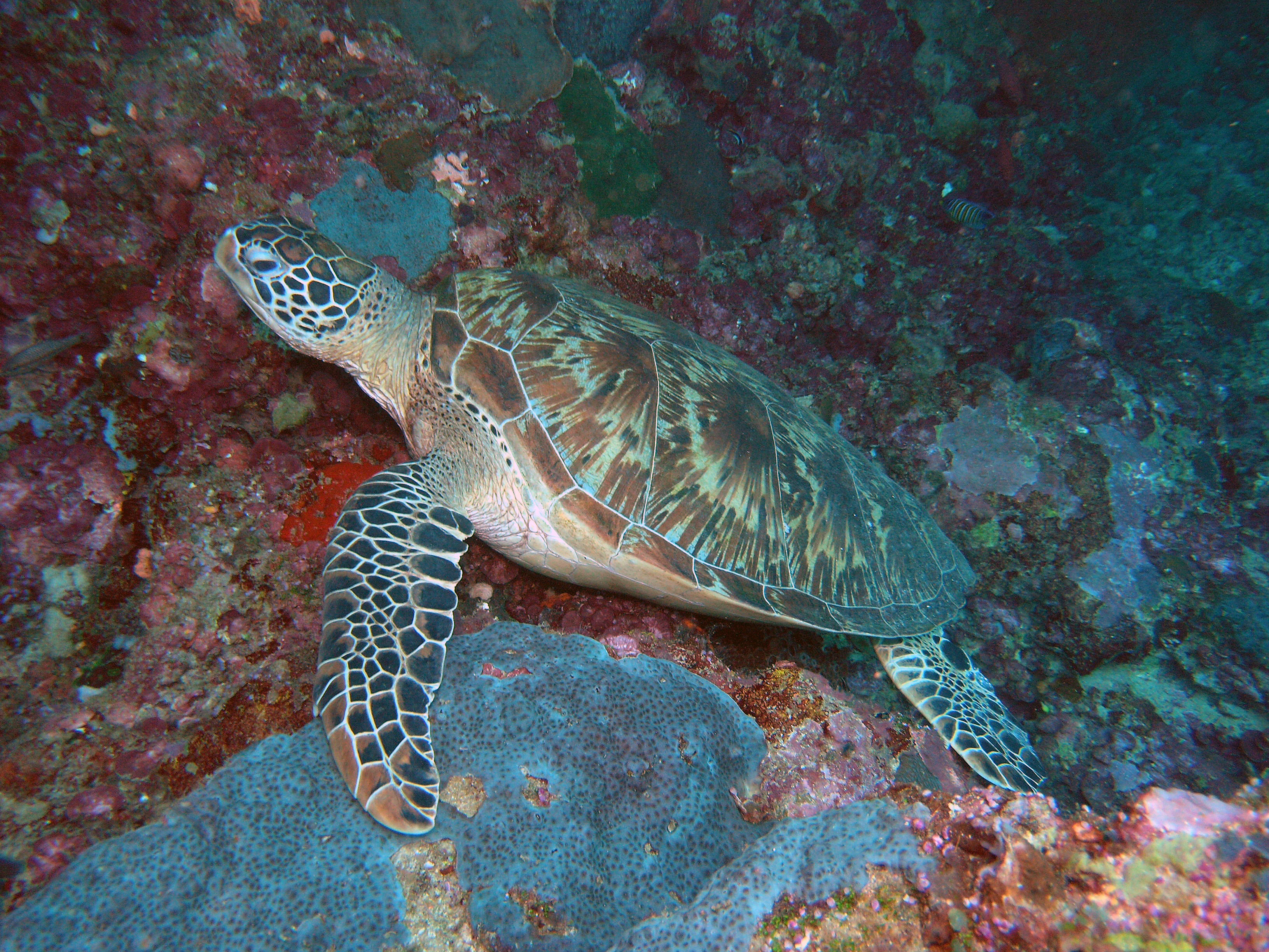
A sea turtle with a patterned shell resting on a textured, colorful underwater coral reef.
A sea turtle resting on a coral reef in the waters of Sipadan Island Park.

Sipadan Island Park wildlife and species highlights

Sipadan Island Park is internationally known for the density and diversity of its marine wildlife, and encounters with charismatic species are central to its reputation. The waters around the island are home to large numbers of sea turtles, particularly green sea turtles and hawksbill turtles, which use the area for mating and nesting and are frequently encountered on the reefs and beaches. Encounters with schools of barracuda arranged in tornado-like formations, dense aggregations of big-eye trevally, and groups of bumphead parrotfish grazing on the reef are among the park's signature wildlife experiences.

Pelagic visitors add another layer of life to the park. Manta rays, eagle rays, scalloped hammerhead sharks, and whale sharks have all been recorded around Sipadan, reflecting the park's position along routes and habitats frequented by wide-ranging open-ocean species. Sightings of killer whales have also been reported in the area, underscoring the connection between the reefs of Sipadan and the broader pelagic ecosystem of the Celebes Sea.

One of the most striking wildlife-related features in the park is the Turtle Tomb, an underwater limestone cave system beneath the island. The cave contains a labyrinth of tunnels and chambers where the skeletal remains of sea turtles have accumulated over time, the result of turtles entering the system, becoming disoriented beneath the limestone column, and drowning before finding their way back to the open water. It is a haunting natural feature and one of the park's most widely discussed underwater sites, adding a distinctive dimension to Sipadan's wildlife profile.
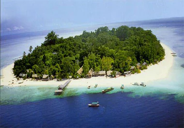
Aerial view of a small, lush green tropical island surrounded by a white sand beach and turquoise and deep blue ocean waters with several boats docked at a pier.
An aerial view of Sipadan Island, showing its dense tropical vegetation and white sand beaches surrounded by coral reefs.

Sipadan Island Park conservation status and protection priorities

Sipadan Island Park's conservation significance lies in the combination of its biodiversity, its geological setting, and its position within the Indo-Pacific basin. The reef ecosystems of Sipadan and the surrounding waters sit at the heart of one of the most marine-biodiverse regions in the world, and the park therefore plays a meaningful role in protecting reef habitats and the species assemblages they support. The island's protected status has a long lineage, beginning with its 1933 designation as a bird sanctuary under the colonial government of North Borneo and continuing through re-gazetting in 1963 and the formal declaration of the marine park in 2004.

Modern management of the park reflects lessons learned from the pressures of rapid tourism growth. The closure of all six resort and hotel facilities on Sipadan in 2004 removed a significant source of localised pressure on the reef, including wastewater, anchorage damage, and direct shoreline disturbance, and concentrated the park's visitor footprint on regulated diving activities. Daily permit limits were introduced to control visitor numbers, dive marshals were appointed in 2016 to monitor underwater activity, and the park's total area was expanded in 2015 to extend protection to additional reef and ocean habitat. Periodic closures, including a one-month closure in November 2023, have been used as short-term recovery measures to allow the ecosystem to recover from accumulated human disturbance.

Beyond its local management regime, Sipadan Island Park is recognised internationally as a model for marine-protected-area management in a working dive setting. Its combination of strict access controls, on-island development removal, and active underwater monitoring has made it a frequently cited example in discussions of how to balance high-value tourism with long-term reef protection in the Coral Triangle.

Sipadan Island Park cultural meaning and human context

Sipadan's cultural and political context is shaped primarily by its location at the intersection of Malaysian, Indonesian, and broader Southeast Asian maritime geography, rather than by a deep on-island human heritage. The island lies near Semporna, a coastal town on the east coast of Sabah that serves as the main gateway for visitors and is also associated with the Bajau Laut, a maritime community traditionally linked to the waters around the islands of the Celebes Sea.

The most significant cultural-historical dimension of Sipadan in recent decades is its territorial history. The island was claimed by both Malaysia and Indonesia, and the dispute was eventually settled by the International Court of Justice in 2002 in favour of Malaysia, a decision that continues to shape how the island is discussed regionally. The 2000 Abu Sayyaf kidnapping at Sipadan also became a notable episode in the broader security history of the Semporna and Semporna-Sulu Sea region, with lasting effects on how the island is managed and protected.

Top sights and standout views in Sipadan Island Park

Sipadan Island Park's standout features include its sheer coral walls and drop-offs along the flanks of the volcanic seamount, and the dense marine life that those structures concentrate. The park's schools of barracuda in tornado-like formations and its reliable encounters with green and hawksbill sea turtles are among the defining experiences of the area. The Turtle Tomb cave system, with its labyrinth of tunnels and accumulated turtle remains, gives the park a uniquely distinctive underwater feature. Its combination of strict permit-based access, absence of on-island resorts, and position at the heart of the Indo-Pacific basin gives Sipadan Island Park a particularly strong profile as both a conservation site and a dive destination.

Best time to visit Sipadan Island Park

Sipadan Island Park can be visited year-round as a dive destination, but conditions vary with the regional monsoon patterns of the Celebes Sea off Sabah. The dry season, generally running from roughly March to September, tends to bring calmer seas, better visibility, and more predictable surface conditions, which is favourable for diving and for accessing the park's outer dive sites. The wetter months can bring heavier rain, larger swells, and reduced visibility at times, although diving remains possible and the reefs can appear especially vibrant during transitional periods. Because the park's underwater environment is the main attraction, the most meaningful seasonal guidance relates more to diving conditions and sea state than to terrestrial weather; visitors generally plan trips around periods of stable weather and clear water if they wish to experience Sipadan's pelagic encounters at their best.

Monthly climate preview

Long-term temperature and precipitation averages recorded at representative coordinates

Sipadan Island Park Climate Normals and Monthly Weather Patterns

Sipadan Island Park maintains consistent monthly temperature averages alongside measured precipitation rhythms tracked from 1991 through 2020. Reviewing the comprehensive twelve-month climatology data provides deeper insight into annual environmental conditions across the protected terrain.
Annual mean28 °C
27 °C28 °C
Jan27°
Feb27°
Mar28°
Apr28°
May28°
Jun28°
Jul28°
Aug28°
Sep28°
Oct28°
Nov28°
Dec28°
Warmest month
May

28.3 °C

Coolest month
January

27.2 °C

Wettest month
December

7.4 mm/day

Driest month
September

4.8 mm/day

Park location guide

Geography guide, regional context, and park location map for Sipadan Island Park

Sipadan Island Park park geography, regions, and map view in Malaysia

Understand where Sipadan Island Park sits in Malaysia through a broader geographic reading of the surrounding landscape, nearby location context, and its mapped position within the national park landscape.

How Sipadan Island Park fits into Malaysia

Malaysia is a federal constitutional monarchy located in Southeast Asia. The country consists of 13 states and three federal territories, divided by the South China Sea into Peninsular Malaysia on the Indochinese Peninsula and East Malaysia on the island of Borneo. With a population of over 34 million, it achieved independence from Britain in 1957 and became a modern federation in 1963. The country is recognized for its multicultural population, tropical climate, and significant economic role in the region.

Wider geography shaping Sipadan Island Park in Malaysia

Malaysia occupies a strategic position in Southeast Asia, split by the South China Sea into two distinct regions. Peninsular Malaysia lies on the Indochinese Peninsula, sharing a land border with Thailand to the north and maritime borders with Singapore, Vietnam, and Indonesia. East Malaysia occupies the northern portion of Borneo, sharing land borders with Brunei and Indonesia, and maritime borders with the Philippines and Vietnam. The country's terrain includes coastal plains, mountain ranges such as the Titiwangsa in the peninsula, and extensive tropical rainforests.

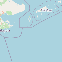
Map view of Sipadan Island Park

Use this park location map to pinpoint Sipadan Island Park in Malaysia, understand its exact geographic position, and read its mapped placement within the surrounding landscape more clearly.

Pigeon | © OpenStreetMap contributors

Location context for Sipadan Island Park

Sabah

Visual reference guide to volcanic seamounts, coral walls, and marine habitats.

Sipadan Island Park Photos and Scenery: Exploring Marine Landscapes

Visual records capture the dramatic underwater terrain and steep coral walls that define the protected marine environment of Sipadan Island Park. Examining field photography reveals the unique geological relief of the submerged volcanic seamount and its surrounding reef habitats.

An underwater view showing a massive school of fish on the right and a coral reef on the left, with shafts of light filtering down through the water.

A sea turtle resting on a textured, multicolored coral reef underwater.

A small, tree-covered tropical island sits in the middle of a calm, deep blue sea under a light blue sky with faint clouds.

A sea turtle with a patterned shell resting on a textured, colorful underwater coral reef.

Aerial view of a small, lush green tropical island surrounded by a white sand beach and turquoise and deep blue ocean waters with several boats docked at a pier.

Park atlas

Compare adjacent marine protected areas and regional conservation landscapes

Explore Other Parks Near Sipadan Island Park and Surrounding Marine Reserves

Browse nearby national parks and protected marine zones to examine regional biodiversity patterns across the Celebes Sea. Expanding the search helps connect isolated oceanic reef systems with broader coastal and island habitats in the Indo-Pacific basin.
National parkSabah
About 54 km away#1 closest

North

Tun Sakaran Marine Park National Park: Sabah Marine Archipelago Atlas

Explore the islands, sand cays, and coral reef geography.

Tun Sakaran Marine Park is a protected national park in Sabah, Malaysia, known for its stunning marine biodiversity and archipelago landscape. This atlas entry details the park's distinct islands, dynamic sand cays, and extensive coral reef systems within the Celebes Sea, offering insights into its unique geographic setting and ecological significance.

Area
101 km²
Established
2004
IUCN
II
Relief
Lowland
National parkSabah
About 87 km away#2 closest

West

Tawau Hills National Park: Mapped Boundaries and Protected Landscape Identity in Sabah

Explore the geographic scope and regional context of Tawau Hills National Park.

Gain a structured understanding of Tawau Hills National Park as a protected area within the geography of Sabah, Malaysia. This resource details its significance as a national park, highlighting its mapped landscape and its contribution to the regional geographic context. Ideal for users interested in atlas exploration and comprehending the distribution of protected lands.

Area
280 km²
Established
1979
IUCN
II
Relief
Mountain
Wildlife reserveSabah
About 127 km away#3 closest

North

Tabin Wildlife Reserve: Exploring Protected Landscapes and Terrain in Eastern Sabah

An essential conservation stronghold featuring unique mud volcano terrain and dipterocarp forest.

Tabin Wildlife Reserve encompasses a sprawling expanse of lowland jungle in the heart of the Dent Peninsula. This protected area plays a vital role in safeguarding Borneo's largest mammal populations and maintaining the ecological connectivity of riverine habitats and mineral-rich forest floors within the Sabah region.

Area
1,225 km²
Established
1984
IUCN
IV
Relief
Lowland
A soft watercolor painting of a winding river flowing through a lush, misty green forest under pale hills.
Wildlife reserveSabah
About 139 km away#4 closest

Northwest

Danum Valley Conservation Area: Protected Lowland Rainforest Geography in Sabah

Examining the boundaries and terrain of this Bornean wildlife reserve

Danum Valley Conservation Area serves as a primary site for understanding undisturbed lowland dipterocarp forest in Borneo. This wildlife reserve features a complex bowl shaped basin of rivers, ridges, and dense tropical canopy. Access geographic maps and site data to understand the structural integrity of this protected region located within the state of Sabah.

Area
438 km²
Established
1980
IUCN
Ia
Relief
Highland
Nature reserveSabah
About 208 km away#5 closest

West

Maliau Basin Nature Reserve: Geographic Overview and Protected Landscape Mapping

Sandstone escarpments and river drainage in Sabah, Malaysia

Explore the structural geography of Maliau Basin, a prominent nature reserve in Sabah. This protected area is defined by its massive sandstone depression, multi-tiered waterfalls, and expansive primary forest coverage. Examine the watershed dynamics of the Maliau River and the mountainous terrain that isolates this significant wilderness from surrounding lowland regions.

Area
588 km²
Established
1981
IUCN
Ia
Water
Major water bodies
Wildlife reserveTawi-Tawi
About 221 km away#6 closest

North

Turtle Islands Wildlife Sanctuary: Mapping the Protected Archipelago of Tawi-Tawi

Coastal landscapes, marine habitats, and island terrain

Spanning six islands at the maritime boundary of the Philippines and Malaysia, Turtle Islands Wildlife Sanctuary is defined by its extensive nesting beaches and remnant forest. This protected area integrates marine and coastal habitats, ranging from the volcanic activity on Lihiman to the forested shores of Baguan, offering a unique look at the maritime geography of the Tawi-Tawi region.

Area
2,429.67 km²
Established
1999
National parkMalaysia
About 234 km away#7 closest

North

Turtle Islands National Park: Marine Protected Area and Island Geography in Malaysia

Coastal landscapes and coral reef protected zones

Explore the geographic footprint of Turtle Islands National Park, a marine-focused sanctuary in Malaysia. This protected area encompasses three islands and surrounding Sulu Sea reef ecosystems, providing critical nesting habitat for marine turtles. Learn about the island-based terrain and the marine boundaries that define this protected landscape.

Area
17.4 km²
Established
1977
Relief
Lowland
Climate
Tropical
National parkSabah
About 234 km away#8 closest

North

Turtle Islands National Park: Marine Geography and Protected Island Landscapes in Sabah

A Sulu Sea sanctuary for coral reefs and sea turtle nesting grounds.

Located north of Sandakan, Turtle Islands National Park is a key marine protected area defined by its island geography and extensive coral reef habitat. The park protects critical nesting beaches for green and hawksbill sea turtles, offering a focused look at how marine conservation intersects with tropical island terrain in the Sulu Sea. This geographic profile details the park's offshore environment and its connection to broader maritime conservation efforts in the region.

Area
17.4 km²
Established
1977
IUCN
II
Relief
Lowland

Common questions about visiting, size, designation, and location context for Sipadan Island Park

Sipadan Island Park FAQs for park facts, access, geography, and protected area context

Find quick answers about Sipadan Island Park, including protected-area facts, park geography, trail and visitor context, and how the park fits into its surrounding country and regional landscape.
MoriAtlas Explorer

Continue Your Protected Areas Search Across the Global Atlas

Deepen your exploration by continuing the structured search for national parks and protected areas worldwide. Utilize the comprehensive filtering capabilities to compare different conservation landscapes and refine your understanding of global park geography. Discover more about the distribution and characteristics of protected natural areas.

Global natural geography
