
Wetlands
Park geography
Detailed analysis of park boundaries, elevation spans, and mapped natural landscapes
Structured Geographic Profile of Skuleskogen National Park in Västernorrland County, Sweden
Examine the technical geography of Skuleskogen National Park, covering its 30.62 square kilometer span across coastal and mountainous terrain. This profile details the park elevations ranging up to 280 meters, alongside categorized forest habitats, valleys, peaks, and coastal features within the Västernorrland regional landscape.
Coastal taiga forest with dramatic crevasses on the rebounding High Coast
Skuleskogen National Park
Skuleskogen National Park is a Swedish protected area in Västernorrland County along the Baltic Sea coast, forming the eastern portion of the Forest of Skule. Established in 1984 and expanded in 2009, the park covers 30.62 square kilometers of rugged terrain characterized by rocky peaks, deep crevasses, and dense coniferous forest. The park sits within the High Coast region, a UNESCO World Heritage Site renowned for the phenomenon of post-glacial rebound—the land here rises approximately 8 millimeters per year as it recovers from the weight of glacial ice that melted less than 10,000 years ago. The landscape features dramatic fracture valleys, steep cliffs, and coastal archipelago views, with the highest peak Slåttdalsberget rising 280 meters directly from the sea. The park supports diverse ecosystems including boreal taiga forest, rocky heathland, wetlands, and small lakes, home to notable species including Eurasian lynx and brown bear.
- Location
- Sweden
- Park type
- National park
- Established
- 1984
- Area
- 30.6 km²
- Highest point
- 280 m
Location overview
Regional placement in Västernorrland County plus marine and coastal status
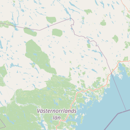
Geographic Location of Skuleskogen National Park in Sweden
Skuleskogen National Park is situated within Västernorrland County in Sweden. The protected landscape features verified coastal and marine territories managed under a single national jurisdiction.
- Countries
- Sweden
- Regions
- Västernorrland County
- Primary location
- Sweden
- Geographic setting
- Coastal · Marine
Boundary and coordinates
Skuleskogen’s outline pairs 27.8 km² land and 2.82 km² marine area
Skuleskogen National Park mapped boundary and area breakdown
Skuleskogen National Park has stored geometry defining its mapped protected boundary. Its 30.62 km² overall area divides exactly into 27.8 km² of land and 2.82 km² of marine coverage, with no perimeter recorded.
- Boundary area
- 30.6 km²
- Boundary perimeter
- 25.4 km
- Northernmost point
- 63.1396° N
- Southernmost point
- 63.0825° N
- Easternmost point
- 18.5537° E
- Westernmost point
- 18.4067° E
- Geographic centre
- 63.111° N, 18.4841° E
- North–south span
- 6.4 km
- East–west span
- 7.4 km
Elevation and terrain
Mountain relief metrics and recorded interior natural features
Skuleskogen National Park Terrain and Elevation Range Geography
Elevation summary metrics track vertical terrain bounds spanning from zero up to two hundred eighty meters. Linked feature cards document official names, types, and spatial relationships for interior wetlands, lakes, peaks, and streams.
- Minimum elevation
- 0 m
- Maximum elevation
- 280 m
- Highest point
- 280 m
Selected named natural features
Lakes
Ytterbölestjärnen
Lakes
Långtjärnen
217 m
Peaks
Lillruten
Wetlands
Rödmossamyran
Lakes
Tärnättvattnen
Environmental setting
Analysis of subpolar relief, boreal forest cover, and coastal water features
Skuleskogen National Park Environmental Classifications and Physical Setting
Recorded classifications frame the physical setting through complementary habitat zones, relief types, and landscape features. Stored categories connect directly to relevant atlas destinations for broader regional context.
- Relief
- Mountain
- Climate
- Subpolar
- Water
- Major water bodies
- Forest cover
- Mostly forested
- Seasonality
- Year-round
Landscape features
Mountains · Valleys · Cliffs · Canyon · Forest · Woodland · Rivers · Wetland · Coast · Beach · Cave
Habitat types
Boreal forest · Temperate coniferous forest · Wetland · Riverine habitat · Lacustrine habitat · Coastal habitat
Park atlas
Trace the regional spread of protected areas, comparing landscapes and conservation efforts near Skuleskogen National Park.
Explore Other National Parks and Protected Landscapes Near Skuleskogen National Park
After exploring Skuleskogen National Park, continue your discovery by browsing other national parks and protected areas in the High Coast region and surrounding Swedish geography. Comparing these diverse conservation landscapes provides valuable insights into the distinct post-glacial rebound geology and boreal ecosystems of northern Europe.
National parkVästerbotten County
92 km away#1 closest
North

Björnlandet National Park: Ancient Pine Forest & Dramatic Protected Landscape in Västerbotten County
Explore mapped boreal terrain and protected area boundaries.
Björnlandet National Park preserves an exceptional example of Sweden's ancient boreal forest, with pines exceeding 450 years in age. The protected landscape is dramatically shaped by steep ravines, cliff faces, and extensive boulder fields, showcasing the raw power of natural processes and fire history. This national park offers a unique opportunity for atlas-style exploration of its mapped terrain and geographic context within Västerbotten County.
- Area
- 11 km²
- Established
- 1991
- IUCN
- II
- Relief
- Mixed relief
National parkFinland
208 km away#2 closest
Southeast

Lauhanvuori National Park: Finland's Protected Landscape and Geographic Identity
Mapped protected area within Finland's regional geography.
Delve into the protected landscape of Lauhanvuori National Park, a key national park in Finland. This atlas-focused entry details its geographic setting and mapped boundaries, offering structured insight into its protected area status and natural terrain. Understand how Lauhanvuori National Park contributes to Finland's broader conservation geography and landscape context.
- Area
- 53 km²
- Established
- 1982
- IUCN
- II
- Visitors
- 21.7K annual
National parkFinland
214 km away#3 closest
Southeast
Kauhaneva-Pohjankangas National Park: Protected Landscape and Geographic Context in Finland
Mapped boundaries and regional terrain of a Finnish national park.
Discover Kauhaneva-Pohjankangas National Park, a key protected area in Finland, through a structured atlas lens. This detail page provides essential information on its geographic setting, mapped natural landscapes, and protected area status, offering a deep dive into the park's physical identity. Understand its unique terrain and its significance within the Nordic region's geography for focused exploration.
- IUCN
- II
National parkGävleborg County
236 km away#4 closest
Southwest
Hamra National Park: Ancient Forests, Mires, and Protected Landscape in Gävleborg County
Discover pristine Swedish nature and mapped park boundaries.
Hamra National Park in Gävleborg County, Sweden, protects an extraordinary natural landscape. At its heart lies a distinct moraine hill adorned with some of central Sweden's oldest coniferous trees, some reaching 400 years. Surrounding this ancient forest is a vast, unbroken expanse of mire and wetland, a landscape preserved from drainage and modification. This park offers a profound insight into pristine ecosystems and geographic context, making it a key destination for atlas exploration of protected natural areas.
- Area
- 13.83 km²
- Established
- 1909
- IUCN
- II
- Relief
- Lowland
National parkTrøndelag
242 km away#5 closest
Northwest

Lierne National Park: A Protected Mountain and Wetland Wilderness in Trøndelag
Explore mapped boundaries, alpine terrain, and Scandinavian wilderness.
Lierne National Park is a prime example of Norway's protected mountain and wetland landscapes, situated in the Trøndelag region. This national park offers a detailed study of terrain shaped by glacial activity, featuring high peaks and expansive peat bogs. Its role in preserving habitats for large carnivores and the Arctic fox adds ecological depth to its geographic profile, providing valuable context for atlas-based discovery of protected areas.
- Area
- 333 km²
- Established
- 2004
- IUCN
- II
- Relief
- Mountain
National parkSweden
258 km away#6 closest
West
Sonfjället National Park: Mapped Alpine Terrain and Protected Landscape in Sweden
Explore the glacial geography and subalpine transition zones.
Sonfjället National Park is a key protected area in central Sweden, offering a unique glimpse into an alpine environment shaped by glacial forces. The park's landscape is characterized by the prominent Sånfjället mountain, steep glacial valleys, mires, and small lakes, showcasing raw, natural terrain. As a southern outpost for subalpine ecosystems, it presents a distinct ecological transition zone valuable for geographic discovery and understanding protected nature.
- IUCN
- II
National parkSouthwest Finland
About 269 km away#7 closest
Southeast
Bothnian Sea National Park: Southwest Finland's Coastal Protected Landscape
Mapped geography and regional protected area context.
Bothnian Sea National Park stands as a significant protected landscape situated within the extensive island formations of Southwest Finland's Archipelago Sea. This page provides an atlas-focused view of the national park, detailing its geographic spread, mapped boundaries, and its place within the regional context of Varsinais-Suomi. Understand the protected area's unique coastal identity and its contribution to the mapped natural terrain of southern Finland, facilitating structured discovery and geographic exploration.
- Area
- 917 km²
- Established
- 2011
- IUCN
- II
- Visitors
- 79.4K annual
National parkFinland
278 km away#8 closest
Southeast
Seitseminen National Park: Ancient Boreal Forests and Vast Mire Systems in Finland
Explore mapped terrain and protected wilderness landscapes.
Seitseminen National Park represents a significant protected area in western Finland, characterized by classic boreal forest ecosystems interspersed with extensive mire and bog landscapes. The park's geography includes the notable Seitsemisharju esker, contributing to its diverse terrain. As a sanctuary for ancient forests, including the historic Multiharju primeval forest, Seitseminen offers a unique focus for understanding Finnish protected wilderness and its mapped geographic features within the Nordic context.
- Area
- 45.5 km²
- Established
- 1982
- IUCN
- II
- Visitors
- 42.3K annual
MoriAtlas Explorer
Continue Exploring Skuleskogen National Park's Geographic Atlas
Deepen your understanding of Skuleskogen National Park by exploring its specific geographic context within the High Coast region. Examine the mapped boundaries of this protected landscape, learn about its unique post-glacial rebound phenomena, and appreciate its rugged terrain through structured atlas data. MoriAtlas provides the geographic details to contextualize this significant Swedish national park and its place in the natural world.
Browse next
Global natural geography
Explore related park routes
Explore MoriAtlas Global ParksBrowse All MoriAtlas ParksGlobal Park Map DiscoveryMoriAtlas: Browse All CountriesBrowse All MoriAtlas ContinentsNational Park Environment AtlasGrand Canyon National Park AtlasYellowstone National Park AtlasYosemite National Park Atlas and GeographySerengeti National Park AtlasGalápagos National Park Protected LandscapeBanff National Park Geography and AtlasKruger National Park Atlas EntryUluṟu-Kata Tjuṯa National Park AtlasExplore Uluru-Kata Tjuta National Park GeographyPlitvice Lakes National Park AtlasFiordland National Park Protected LandscapeGreat Smoky Mountains National Park AtlasAfghanistan National Parks and Protected AreasAlbania National Parks and Protected AreasAlgeria National Parks and Protected AreasAmerican Samoa National Parks and Protected AreasAndorra National Parks and Protected AreasAngola National Parks and Protected AreasAntarctica National Parks and Protected AreasAntigua and Barbuda Park List