
Mori Atlas logo
National parkSłowiński Park Narodowy

A study of dynamic coastal terrain, lake basins, and protected mire landscapes in the Pomorskie Voivodeship

Słowiński Park Narodowy: Analyzing the Baltic Coast Moving Sand Dunes and Coastal Wetlands

Słowiński Park Narodowy represents a unique coastal geography where the Baltic Sea interacts with a barrier spit of shifting sand dunes, peat bogs, and interconnected lake systems. This protected area showcases ongoing geological processes, including the inland migration of dune fields and the evolution of coastal lowlands. Through map-based analysis, observe the structural interplay between the Łebska Spit, Lake Łebsko, and the surrounding pine-forested wetlands.

national parkcoastal landscapemoving dunesBaltic Seacoastal lakespeat bogs
A graphic illustration showing a stylized mountain landscape with a cascading waterfall flowing into a river through a green valley surrounded by evergreen trees.

Słowiński Park Narodowy

National park

Park overview

Structured park overview, official facts, and landscape profile for Słowiński National Park

Słowiński National Park park facts, protected area profile, and essential visitor context

Review the core facts for Słowiński National Park, including designation, size, terrain, visitor scale, habitats, and operating context in one park-focused overview.

About Słowiński National Park

Słowiński National Park sits on the central Polish coast, between the Baltic Sea and a chain of large coastal lakes. It spans the Łebska Spit, a long sandy barrier, the Gardno-Łeba lowlands behind it, and parts of the terminal moraine left by the last glaciation, whose highest point, Rowokół at around 115 meters, is one of the most prominent features of the interior.

The landscape is unusually active for a protected area. The park includes one of Europe's most prominent belts of moving sand dunes, which still shift inland through wind action. Coastal lakes, raised bogs, wet meadows, and pine-dominated coastal forests create a layered mosaic of habitats that change both spatially, as dunes advance and bury forest, and ecologically, as new successional communities take hold on freshly exposed sand.

Słowiński is a protected area of national and international standing. It was established on 1 January 1967 and has been a UNESCO biosphere reserve since 1977 and a Ramsar Convention wetland site since 1995. The park's identity is not centered on charismatic megafauna but on dynamic geological processes, coastal hydrology, and a rich plant and bird community that adapts to an environment in constant change. Its dunes, lake shores, peat bogs, and forests offer a compact but complete portrait of the southern Baltic coastal landscape.

Quick facts and research context for Słowiński National Park

Słowiński National Park lies on the middle Polish coast in the Pomeranian Voivodeship; its headquarters are in the village of Smołdzino. The protected landscape includes the Łebska Spit, the Gardno-Łeba Lowland, fragments of the last glaciation's frontal moraine, and several coastal lakes led by Lake Łebsko and Lake Gardno.

Its central highlight is a chain of moving sand dunes running along the Łebska Spit, alongside peat bogs, lake shores, wet meadows, and pine-dominated coastal forests. The park has been a UNESCO biosphere reserve since 1977 and a Ramsar wetland site since 1995, underscoring both its landscape and ecological value at international level.

Protection and recognition

Documented conservation scope, established protection history, and international recognition details

Słowiński Park Narodowy Protection Status and Designation History

Established in 1967, Słowiński Park Narodowy maintains a mixed protection scope governed by documented national designation records. Review the official establishment history and baseline administrative frameworks associated with this protected natural area.

Protection details

Protection scope
Mixed
Designated year
1967
Transboundary protection
No
Core area
53.92 km²
Buffer area
302.2 km²
Park context

Deeper park guide and search-rich context for Słowiński National Park

Słowiński National Park history, landscape, wildlife, and travel context

Explore Słowiński National Park through its history, landscape character, ecosystems, wildlife, conservation priorities, cultural context, and seasonal travel timing in a structured park guide built for atlas discovery and search intent.

Why Słowiński National Park stands out

Słowiński National Park is best known for its moving sand dunes, one of the most remarkable dune systems along the Baltic coast. The dunes, most famously Łączka and the Czołpińska Dune, advance inland through a process still active today, occasionally uncovering the remains of forests buried thousands of years ago. The park is equally noted for the interplay between these dunes and a chain of large coastal lakes and raised bogs. Lake Łebsko, Lake Gardno, and the surrounding mires and meadows form a coherent coastal wetland mosaic that supports large numbers of breeding, wintering, and migratory birds. Together, the dunes and the lake system define Słowiński as a park where physical landscape dynamics, not biodiversity statistics, are the main story.
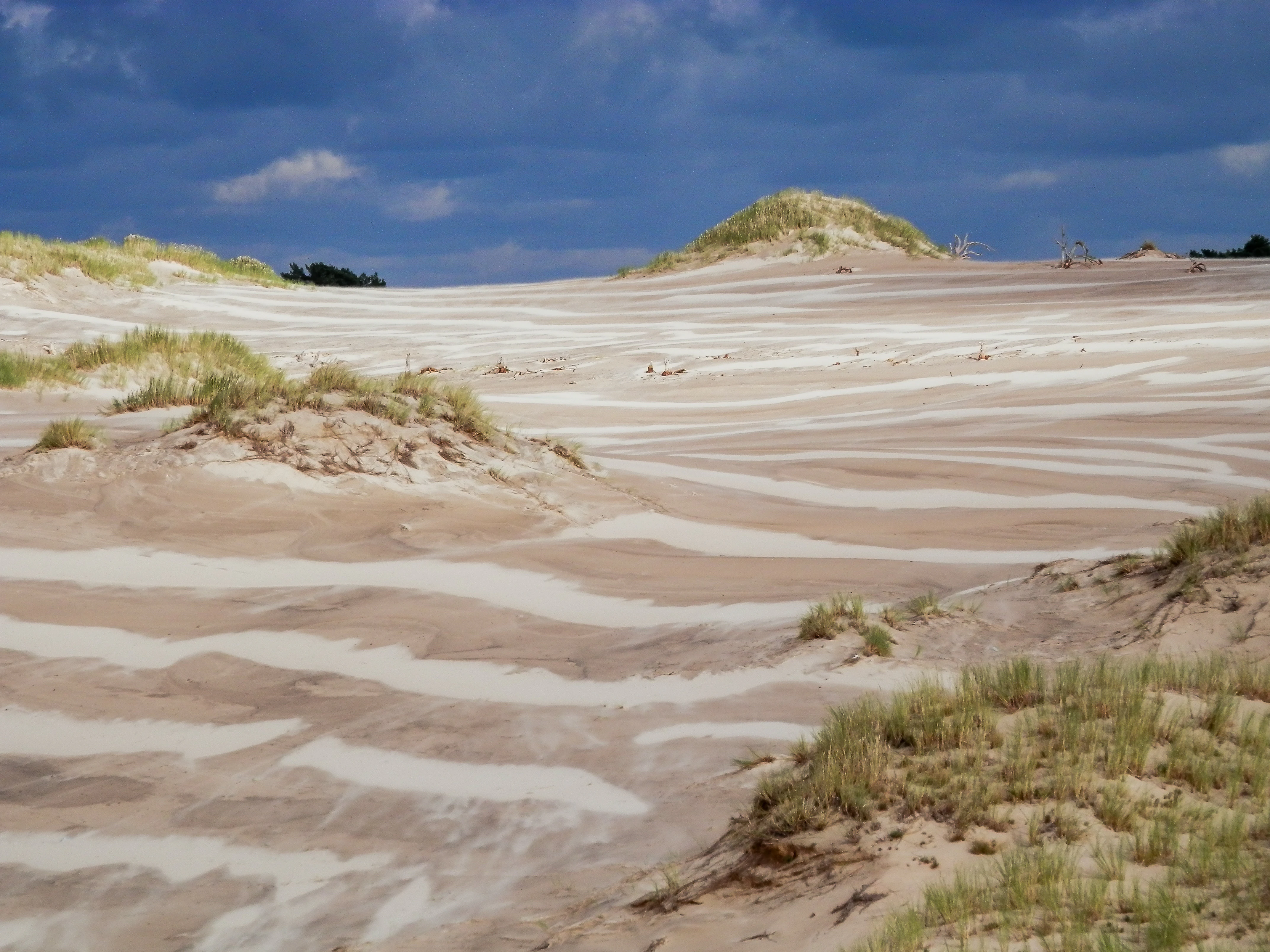
Extensive, rolling sand dunes with patches of dune grass under a dramatic, dark cloudy sky.
The iconic shifting sand dunes of Słowiński National Park, Poland.

Słowiński National Park history and protected-area timeline

Słowiński National Park was officially created on 1 January 1967, with an initial area of around 18,069 hectares focused on the dune belt and the associated lake district. The park's establishment reflected increasing recognition of the Łebska Spit and the adjacent wetlands as a landscape of national significance, where active dune processes, coastal lakes, and bogs coexisted within a relatively compact territory.

In 1977, the park was added to UNESCO's Man and the Biosphere programme as a biosphere reserve, placing it within an international network that highlights the interaction between human activity and natural ecosystems. By 1995, Słowiński had also been listed as a Ramsar wetland site, formally recognizing the international ecological importance of its coastal lakes, peatlands, and bird habitat.

A significant expansion came in 2004, when the park grew by around 14,675 hectares, including roughly 11,000 hectares of Baltic Sea waters. Total area now stands near 32,744 hectares. Over time, the park's role shifted from a chiefly national conservation site to a recognized international benchmark for coastal dune, lake, and wetland management.

Słowiński National Park landscape and geographic character

The landscape of Słowiński National Park is defined by the contrast between the open Baltic shoreline and the calmer, wetland-rich land behind it. The Łebska Spit forms a long, narrow barrier of sand running roughly parallel to the coast, with the dynamic dune belt as its spine and a series of large coastal lakes sitting just inland on the Gardno-Łeba lowland.
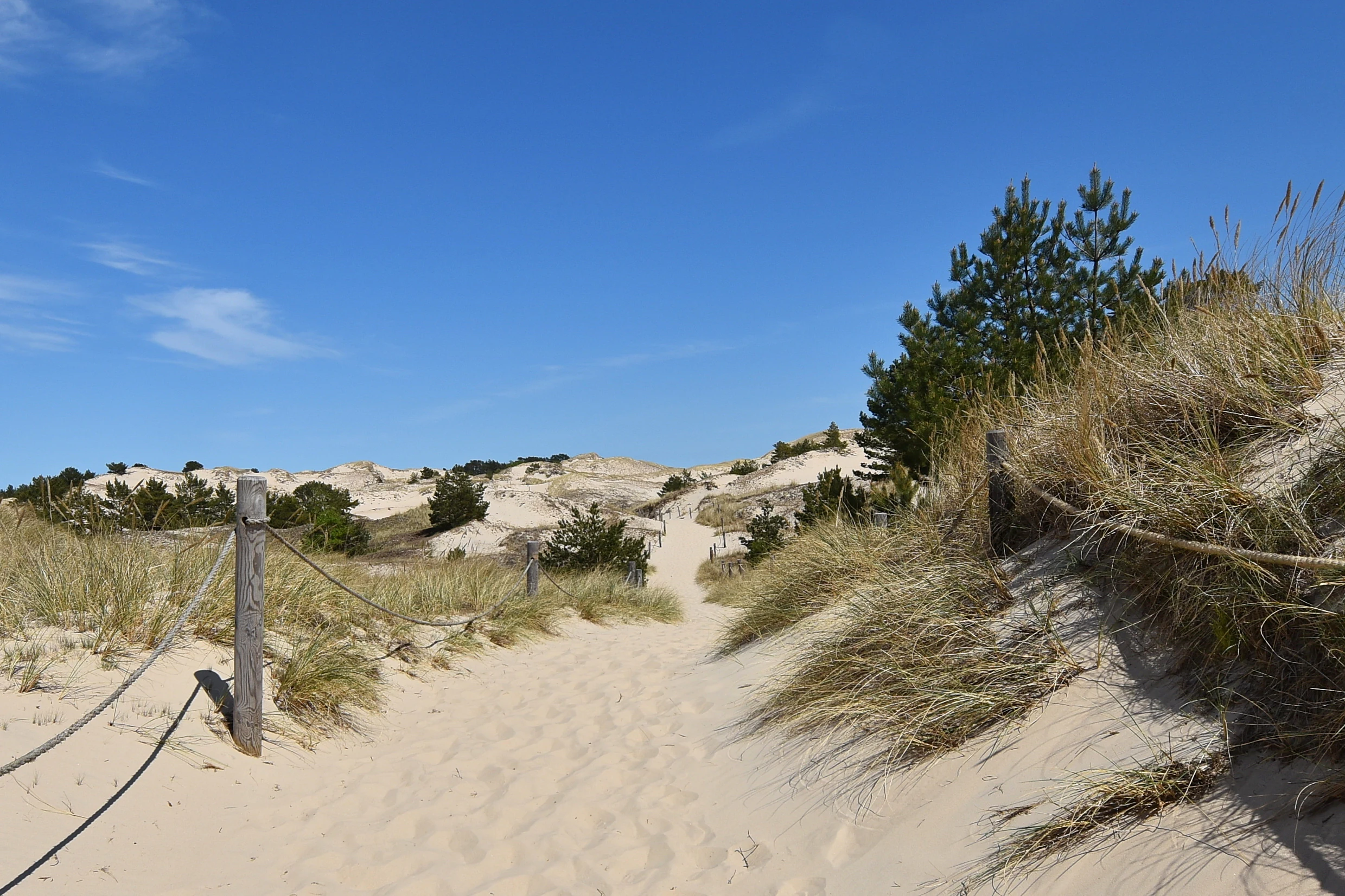
A sandy path marked by wooden posts and rope winds through rolling sand dunes topped with dry dune grasses and scattered pine trees under a clear blue sky.
A sandy trail leads through the shifting dunes at Czołpino in Słowiński National Park.

Słowiński National Park ecosystems, habitats, and plant life

Słowiński protects a layered mosaic of natural value. The shifting dunes are not bare waste; they host pioneer communities of grasses and herbs that stabilize the sand in stages, including marram grass and other classic beach-to-dune colonizers. Behind the dunes, more stable areas support cranberry-pine communities and, eventually, dense coniferous coastal forests.
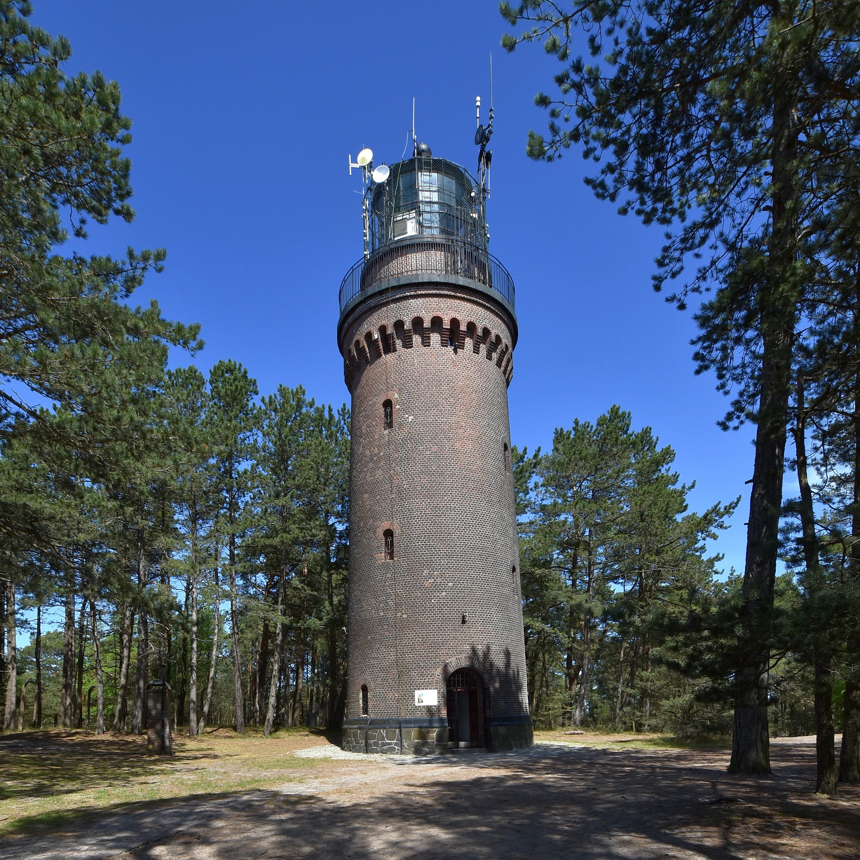
A tall, red-brick lighthouse with a black lantern room at the top, surrounded by pine trees under a clear blue sky.
The historic Czołpino lighthouse stands amidst a pine forest in Słowiński National Park.

Słowiński National Park wildlife and species highlights

Birds are the most conspicuous and ecologically important wildlife group in the park, with around 274 species recorded. About 160 of these breed locally, while others use the area as a stopover or wintering ground. Spring and autumn migrations bring significant movements of waterfowl, waders, and shorebirds through the lakes and coastal meadows.
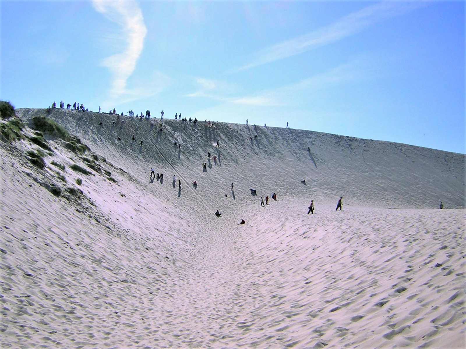
A wide, sunny view of a large, steep sand dune with many small figures of people walking up the slope against a clear blue sky.
Visitors ascending the shifting sand dunes at Łącka Góra in Słowiński National Park.

Słowiński National Park conservation status and protection priorities

Słowiński National Park's conservation importance is unusually broad. It is one of the few protected areas in Europe where active dune migration, large coastal lakes, and internationally important wetland habitat coexist within a single management framework. Its landscape processes are themselves a conservation subject: the protection regime aims to allow dunes to continue shifting rather than freeze them in place, while managing vegetation succession and visitor pressure on the most sensitive zones.

Słowiński National Park cultural meaning and human context

The park takes its name from the Slovincians, or Słowińcy, a small Kashubian-related West Slavic group historically settled around the Łebsko and Gardno lake basins. By the late 19th and early 20th centuries this community had largely been assimilated into the broader Kashubian population, but the cultural legacy remains visible through the Museum of the Slovincian Village in Kluki and other regional heritage institutions that interpret the traditional fishing and agricultural life of the coastal lakes.

Top sights and standout views in Słowiński National Park

The park's main highlight is the belt of moving sand dunes along the Łebska Spit, particularly the Łączka and Czołpińska dunes, which rank among the most active dune formations on the Baltic coast. Behind them lies a tranquil chain of large coastal lakes, notably Lake Łebsko and Lake Gardno, ringed by peat bogs and wet meadows.

Best time to visit Słowiński National Park

Late spring and early summer bring mild conditions, lush vegetation around the lakes and bogs, and active bird breeding, which can make the meadows and dune edges particularly lively. Late summer and early autumn usually offer the most stable weather, with warm sand, clear views from the dune crests, and migratory bird movement in the wetlands.
Monthly climate preview

Long-term representative monthly temperature and precipitation data patterns

Słowiński Park Narodowy Climate Normals and Annual Temperature Rhythm

Measured coordinates for Słowiński Park Narodowy record mean temperatures ranging from sub-zero winter lows to warm summer maximums alongside steady daily precipitation averages. Reviewing the complete twelve-month climate profile reveals the full scope of long-term meteorological shifts across the protected representative point.
Annual mean8 °C
-2 °C18 °C
Jan-2°
Feb-1°
Mar
Apr
May12°
Jun16°
Jul18°
Aug18°
Sep14°
Oct
Nov
Dec
Warmest month
July

18.3 °C

Coolest month
January

-1.8 °C

Wettest month
July

2.8 mm/day

Driest month
April

1.3 mm/day

Park location guide

Geography guide, regional context, and park location map for Słowiński National Park

Słowiński National Park park geography, regions, and map view in Poland

Understand where Słowiński National Park sits in Poland through a broader geographic reading of the surrounding landscape, nearby location context, and its mapped position within the national park landscape.

How Słowiński National Park fits into Poland

Poland, officially the Republic of Poland, is a Central European country spanning from the Baltic Sea in the north to the Carpathian Mountains in the south. It borders Germany, Czech Republic, Slovakia, Ukraine, Belarus, Lithuania, and Kaliningrad Oblast. The country has a temperate climate, diverse landscapes, and is known for its rich history, cultural heritage, and strong economic position within the EU.

Wider geography shaping Słowiński National Park in Poland

Poland occupies 312,696 km2 in Central Europe, extending from the Baltic Sea coast in the north to the Sudetes and Carpathian Mountains in the south. It borders Germany to the west, Czech Republic and Slovakia to the south, Ukraine and Belarus to the east, and Lithuania and Kaliningrad Oblast to the northeast. The landscape includes lowland plains, uplands, and mountain ranges.

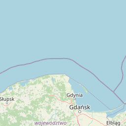
Map view of Słowiński National Park

Use this park location map to pinpoint Słowiński National Park in Poland, understand its exact geographic position, and read its mapped placement within the surrounding landscape more clearly.

Pigeon | © OpenStreetMap contributors

Location context for Słowiński National Park

Pomorskie Voivodeship
Natural feature types

Explore the Geographic Landmarks and Natural Features of Słowiński Park Narodowy

Deepen your understanding of Słowiński Park Narodowy by browsing its significant natural features. MoriAtlas provides a structured overview of the dunes, lake systems, and wetlands that define the geography of this Baltic protected area. Begin tracing these landforms to better visualize the coastal landscape.

Visualizing the moving dunes, coastal lakes, and protected wetland habitats

Słowiński Park Narodowy Photos and Landscape Scenery

Visual records capture the shifting sand dunes, coastal lakes, and pine forests defining Słowiński Park Narodowy. Field photography reveals the scale of active geological processes and wetland habitats across the Baltic shoreline.

Extensive, rolling sand dunes with patches of dune grass under a dramatic, dark cloudy sky.

A wide view of a vast, white sand dune under a clear blue sky, with a wooden fence and rope barrier following a trail path along the side of the slope.

A sandy path marked by wooden posts and rope winds through rolling sand dunes topped with dry dune grasses and scattered pine trees under a clear blue sky.

A tall, red-brick lighthouse with a black lantern room at the top, surrounded by pine trees under a clear blue sky.

A wide, sunny view of a large, steep sand dune with many small figures of people walking up the slope against a clear blue sky.

Park atlas

Compare adjacent coastal terrain, regional wetlands, and connected natural habitats

Explore Parks Near Słowiński Park Narodowy and Surrounding Protected Landscapes

Continue geographic discovery by comparing Słowiński Park Narodowy with other protected areas across the surrounding region. Examining adjacent national parks reveals broader patterns in coastal dune systems, wetland basins, and northern European terrain.
Watercolor illustration of sand dunes, tall grasses, pine trees, and distant mountains under a soft sky
National parkPomeranian Voivodeship
Park boundaries overlap#1 closest

Southeast

Slovincian National Park: Moving Dunes and Baltic Coast Protected Landscape Exploration

Discover its unique geography and mapped terrain.

Slovincian National Park is a protected area in Pomeranian Voivodeship, Poland, celebrated for its impressive moving sand dunes and coastal wetland ecosystems. These dynamic dunes, some reaching 30 meters high, migrate inland, creating an ever-changing landscape. The park also features large shallow lakes like Łebsko and Gardno, vital for migratory birds. Explore the mapped boundaries and geographic context of this significant protected area, a Ramsar site and UNESCO biosphere reserve.

Area
186.18 km²
Established
1967
IUCN
II
Visitors
319K annual
Nature reservePomeranian Voivodeship
About 8.4 km away#2 closest

East

Mierzeja Sarbska Nature Reserve: Protected Coastal Dunes and Barrier Landscape Mapping

Coastal geography within the Pomeranian Voivodeship

Mierzeja Sarbska Nature Reserve preserves a significant sandy barrier along the Baltic coast of northern Poland. The site features active parabolic dunes, interdunal deflation hollows, and unique relict wetland plant communities that provide critical insight into the regional landscape evolution of the Pomeranian Voivodeship.

Area
5.47 km²
Established
1976
Relief
Lowland
Water
Major water bodies
Nature reservePomeranian Voivodeship
About 20 km away#3 closest

Southwest

Rezerwat przyrody Jezioro Modła: Wetland Geography and Protected Coastal Habitat

Nature reserve mapping in Pomeranian Voivodeship, Poland

Focusing on a shallow coastal lake and its surrounding marshland ecosystem, Rezerwat przyrody Jezioro Modła provides vital breeding habitats for waterbirds. The reserve represents a core component of the Pomeranian shoreline, where shifting lake boundaries and dense vegetation define the terrain, highlighting the ecological significance of this protected region.

Area
1.948 km²
Established
1982
Relief
Lowland
Climate
Temperate
Nature reservePomeranian Voivodeship
About 26 km away#4 closest

East

Rezerwat przyrody Długosz Królewski w Łęczynie: Botanical Protected Area in Pomerania

Floristic nature reserve focused on royal fern conservation

Located in the heart of the Puszcza Wierzchucińska, this nature reserve is a critical site for the study and conservation of Osmunda regalis. The surrounding terrain of damp, peat-influenced woodland defines the unique character of this small, specialized protected area in northern Poland.

Area
0.02 km²
Established
1977
Scope
Terrestrial
Water
Minor water
Nature reservePomeranian Voivodeship
About 32 km away#5 closest

East

Długosz Królewski w Wierzchucinie: Mapping a Protected Floristic Peatland Reserve in Pomerania

Floristic nature reserve and bog ecosystem in northern Poland

This protected area in Gmina Krokowa preserves critical peatland habitats, including rare stands of royal fern and interrupted clubmoss. Its geography captures the history of the Wierzchucińska Forest, showcasing a complex environment of moist woodlands and bog mosaics characteristic of the Baltic coastal landscape in Poland.

Area
1.482 km²
Established
2003
Relief
Lowland
Climate
Temperate
Nature reservePomeranian Voivodeship
About 43 km away#6 closest

Southeast

Rezerwat przyrody Jezioro Turzycowe: Wetland Protected Area in Pomeranian Voivodeship

Kashubian Lake District bog forest and dystrophic lake atlas

Rezerwat przyrody Jezioro Turzycowe protects a concentrated mosaic of post-glacial wetland environments, including a dystrophic lake and raised bog habitats. This nature reserve offers deep insight into the specific hydrological and botanical conditions defining northern Polish wilderness corridors.

Area
0.114 km²
Established
1959
Relief
Upland
Climate
Temperate
Nature reservePomeranian Voivodeship
About 54 km away#7 closest

Southeast

Rezerwat przyrody Mechowiska Sulęczyńskie: Geography and Protected Area Landscape Analysis

Alkaline fen and peatland habitat in Pomeranian Voivodeship

Study the geographic distribution and protected status of Rezerwat przyrody Mechowiska Sulęczyńskie, an essential alkaline fen ecosystem in northern Poland. This reserve highlights the role of groundwater-fed landscapes in maintaining orchid populations and bryophyte-rich mires within a post-glacial region. The site serves as a reference point for peatland conservation and structural landscape integrity.

Area
0.252 km²
Established
2014
Relief
Lowland
Climate
Temperate
A soft watercolor painting of gentle, rolling hills and scattered trees under a light sky.
Protected areaPomeranian Voivodeship
55 km away#8 closest

South

Ostoja Masłowiczki: Protected Landscape and Post-Glacial Terrain in Pomeranian Voivodeship

Exploring the glacial basins, bogs, and forests of northern Poland.

Ostoja Masłowiczki is a protected area in the Bytów Lake District defined by its glacial heritage. The site provides a unique look at how moraine landscapes support a varied mosaic of habitats, ranging from acidic dystrophic lakes and active raised bogs to lush oak-hornbeam and beech forests within the Pomeranian region.

Area
16.8 km²
Established
2011
Relief
Lowland
Climate
Temperate

Common questions about visiting, size, designation, and location context for Słowiński National Park

Słowiński National Park FAQs for park facts, access, geography, and protected area context

Find quick answers about Słowiński National Park, including protected-area facts, park geography, trail and visitor context, and how the park fits into its surrounding country and regional landscape.
MoriAtlas Explorer

Continue Your Protected Areas Search Across the Global Atlas

Deepen your exploration by continuing the structured search for national parks and protected areas worldwide. Utilize the comprehensive filtering capabilities to compare different conservation landscapes and refine your understanding of global park geography. Discover more about the distribution and characteristics of protected natural areas.

Global natural geography