Viewpoints
Czołpino Lighthouse
25.2 m high

Analyzing regional terrain, elevation markers, and coastal wetland environments.
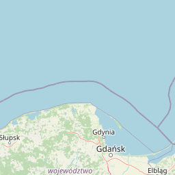
The geographic footprint of Słowiński Park Narodowy spans 327.44 square kilometers within the Pomorskie Voivodeship, defining a complex lowland ecosystem. This profile details the park boundary, mapping internal natural features including shifting dunes, extensive lake systems, and coastal wetlands. Elevation data indicates a temperate terrain reaching a peak of 115 meters, characterizing this protected area's distinct regional geography.
A Baltic coastal park defined by its moving sand dunes, lakes, and shifting landscapes.
Słowiński National Park is a protected area on the central stretch of the Polish Baltic coast, in the Pomeranian Voivodeship. It is one of the country's twenty-three national parks and one of the few in Europe that combines coastal lake systems, large peatlands, and a dynamic belt of moving sand dunes along a narrow spit of land. The park's identity is shaped as much by physical landscape processes as by its ecosystems. Shifting dunes, post-glacial moraine fragments, coastal lakes, raised bogs, wet meadows, and pine-dominated coastal forests create a mosaic of habitats that change visibly over years and decades, not just over centuries. Its importance is recognized well beyond Poland. Słowiński has been part of UNESCO's Man and the Biosphere network since 1977 and is listed under the Ramsar Convention as a wetland of international significance, reflecting the value placed on its dune systems, lake basins, peatlands, and birdlife.
Pomorskie Voivodeship location memberships and coastal attributes
Słowiński Park Narodowy’s mapped boundary covers 327.44 km²
Lowland relief spans and recorded natural features
Viewpoints
25.2 m high
Lakes
Lakes
Lakes
Dunes
Forests
Temperate lowland terrain featuring dominant water, forest cover, and diverse coastal habitats
Forest · Wetland · Lakes · Coast · Beach · Dunes
Temperate coniferous forest · Wetland · Peatland · Coastal habitat · Marine habitat
Compare adjacent coastal terrain, regional wetlands, and connected natural habitats
Southeast

Discover its unique geography and mapped terrain.
Slovincian National Park is a protected area in Pomeranian Voivodeship, Poland, celebrated for its impressive moving sand dunes and coastal wetland ecosystems. These dynamic dunes, some reaching 30 meters high, migrate inland, creating an ever-changing landscape. The park also features large shallow lakes like Łebsko and Gardno, vital for migratory birds. Explore the mapped boundaries and geographic context of this significant protected area, a Ramsar site and UNESCO biosphere reserve.
East
Coastal geography within the Pomeranian Voivodeship
Mierzeja Sarbska Nature Reserve preserves a significant sandy barrier along the Baltic coast of northern Poland. The site features active parabolic dunes, interdunal deflation hollows, and unique relict wetland plant communities that provide critical insight into the regional landscape evolution of the Pomeranian Voivodeship.
Southwest
Nature reserve mapping in Pomeranian Voivodeship, Poland
Focusing on a shallow coastal lake and its surrounding marshland ecosystem, Rezerwat przyrody Jezioro Modła provides vital breeding habitats for waterbirds. The reserve represents a core component of the Pomeranian shoreline, where shifting lake boundaries and dense vegetation define the terrain, highlighting the ecological significance of this protected region.
East
Floristic nature reserve focused on royal fern conservation
Located in the heart of the Puszcza Wierzchucińska, this nature reserve is a critical site for the study and conservation of Osmunda regalis. The surrounding terrain of damp, peat-influenced woodland defines the unique character of this small, specialized protected area in northern Poland.
East
Floristic nature reserve and bog ecosystem in northern Poland
This protected area in Gmina Krokowa preserves critical peatland habitats, including rare stands of royal fern and interrupted clubmoss. Its geography captures the history of the Wierzchucińska Forest, showcasing a complex environment of moist woodlands and bog mosaics characteristic of the Baltic coastal landscape in Poland.
Southeast
Kashubian Lake District bog forest and dystrophic lake atlas
Rezerwat przyrody Jezioro Turzycowe protects a concentrated mosaic of post-glacial wetland environments, including a dystrophic lake and raised bog habitats. This nature reserve offers deep insight into the specific hydrological and botanical conditions defining northern Polish wilderness corridors.
Southeast
Alkaline fen and peatland habitat in Pomeranian Voivodeship
Study the geographic distribution and protected status of Rezerwat przyrody Mechowiska Sulęczyńskie, an essential alkaline fen ecosystem in northern Poland. This reserve highlights the role of groundwater-fed landscapes in maintaining orchid populations and bryophyte-rich mires within a post-glacial region. The site serves as a reference point for peatland conservation and structural landscape integrity.
South
Exploring the glacial basins, bogs, and forests of northern Poland.
Ostoja Masłowiczki is a protected area in the Bytów Lake District defined by its glacial heritage. The site provides a unique look at how moraine landscapes support a varied mosaic of habitats, ranging from acidic dystrophic lakes and active raised bogs to lush oak-hornbeam and beech forests within the Pomeranian region.
Continue analyzing the complex terrain and coastal features of Słowiński Park Narodowy through detailed map-based discovery. Use MoriAtlas to trace the extent of the moving dunes, coastal wetlands, and lake basins that define this important protected area on the Baltic coast.