Mori Atlas logo
Marine protected areaTauterryggen

A pioneer in Norwegian marine conservation, mapping the intersection of glacial geology and deep-water ecosystems.

Tauterryggen Marine Protected Area: Exploring the Glacial Ridge and Cold-Water Coral Geography of the Trondheimsfjord

(Tauterryggen Marine Protected Area)

Tauterryggen is a distinctive underwater geological ridge crossing the Trondheimsfjord in central Norway, formed as an end moraine by retreating glaciers. As one of the earliest marine protected areas established in the country, the site preserves a rare and scientifically significant cold-water coral habitat. The ridge features several shallow banks that host unique biological communities, providing a vital reference point for researchers studying the confluence of marine geology and Arctic-influenced fjord environments.

marine protected areacold-water coral reeffjordTrondheimsfjordglacial geologyend moraine

Tauterryggen

Marine protected area

Park overview

Structured park overview, official facts, and landscape profile for Tauterryggen

Tauterryggen park facts, protected area profile, and essential visitor context

Review the core facts for Tauterryggen, including designation, size, terrain, visitor scale, habitats, and operating context in one park-focused overview.

About Tauterryggen

Tauterryggen is a striking natural feature of the Trondheimsfjord, one of Norway's longest and most ecologically important fjords. The ridge is an end moraine, a depositional landform created at the furthest extent of a glacier's advance during the last ice age. As the ice retreated, it left behind a continuous ridge of sediment that today stretches across the fjord between the communities of Leksvik and Frosta. The same moraine can be traced on the southern shore of the fjord as the Midtsandneset promontory near Midtsandan in Malvik municipality, demonstrating the geological continuity between the ridge and surrounding landscape.

What makes Tauterryggen especially remarkable is not only its origin but also its present ecological role. Several shallow banks along the ridge, including Storgrunnen, Rørvikgrunnen, and Selligrunnen, host thriving communities of Lophelia pertusa, a reef-building cold-water stony coral. Normally this species is found between 200 and 1000 meters depth in waters around 6 to 8 degrees Celsius, but at Tauterryggen the coral survives at depths as shallow as 39 meters, making the ridge the shallowest known cold-water coral reef in the world until an even shallower occurrence was documented in Skarnsundet further inside the fjord in 2014.

Beyond its scientific importance, Tauterryggen represents an early milestone in Norwegian marine conservation. In June 2013, the site was officially protected as a marine protected area alongside Framvaren and Saltstraumen, becoming part of the country's first group of designated marine reserves. Within this protection, activities such as trawling and oil drilling are forbidden, preserving the seabed and its biological communities in an undisturbed state. The combination of glacial geology, unusual coral ecology, and pioneering conservation status makes Tauterryggen a particularly distinctive site within Norway's coastal and marine heritage.

Quick facts and research context for Tauterryggen

Tauterryggen is an end moraine crossing the Trondheimsfjord in central Norway, between Leksvik and Frosta. It is part of Norway's first group of marine protected areas, established in 2013. The ridge hosts the shallowest documented cold-water coral reef in the world, with the reef-forming coral Lophelia pertusa living at depths as shallow as 39 meters. Trawling and oil drilling are prohibited within the protected area.

Protection and recognition

Documented marine protection scope, 2013 designation timeline, and official conservation records

Tauterryggen Protection Status, Marine Designation History, and Formal Recognition Records

Tauterryggen maintains a documented marine protection scope established through official designation history from 2013. Structured conservation records compile baseline management parameters and formal recognition data for this protected area.

Protection details

Protection scope
Marine
Designated year
2013
Transboundary protection
No
Park context

Deeper park guide and search-rich context for Tauterryggen

Tauterryggen history, landscape, wildlife, and travel context

Explore Tauterryggen through its history, landscape character, ecosystems, wildlife, conservation priorities, cultural context, and seasonal travel timing in a structured park guide built for atlas discovery and search intent.

Why Tauterryggen stands out

Tauterryggen is best known for hosting the shallowest known cold-water coral reef in the world, where the reef-forming stony coral Lophelia pertusa survives at just 39 meters depth, far above the 200 to 1000 meter range typically associated with the species. This unusual biological setting, combined with the site's status as one of Norway's pioneering marine protected areas, gives Tauterryggen a globally distinctive identity within fjord ecology and marine conservation. The ridge is also valued as a pristine example of how Norwegian fjords can preserve glacial geological structures along with intact marine ecosystems, providing researchers with a rare reference site where both geological history and deep-water biology can be observed together.

Tauterryggen history and protected-area timeline

Tauterryggen's geological history extends back to the end of the last ice age, when retreating glaciers deposited a continuous end moraine across what is now the Trondheimsfjord. This glacial origin continues to define the ridge's shape, depth profile, and ecological character in the present day.

The site's modern significance began to attract scientific attention through deep-water surveys that revealed an unusually shallow population of cold-water corals. Until 2014, Tauterryggen held the record as the shallowest known location for cold-water coral reefs globally, a distinction that underscored both its ecological uniqueness and its value for marine research.

In June 2013, Tauterryggen, together with Framvaren and Saltstraumen, was formally designated as a marine protected area under Norwegian law. This made the site part of a pioneering group of marine reserves in Norway, the first such designations of their kind in the country. The official spelling Tauterryggen, rather than the older variant Tautraryggen, was confirmed by the Norwegian Mapping Authority (Statens kartverk) on 3 May 2013, coinciding with the formalization of the protected-area status.

Tauterryggen landscape and geographic character

Tauterryggen is a submerged geological ridge that crosses the Trondheimsfjord near its midpoint, with its highest points reaching shallow depths close to the fjord's surface. Although the ridge lies underwater, it is clearly part of the broader glacial landscape of central Norway, having been shaped by the same ice sheets that carved and filled the fjord system.

The end morene extends across the fjord between Leksvik and Frosta, and its continuation can be observed on the southern shore as the Midtsandneset headland near Midtsandan in Malvik. This dual presence, on both sides of the fjord, makes the moraine a continuous topographic feature that links underwater and emerged terrain.

The ridge is broken into several shallow banks, each with its own local name, including Storgrunnen, Rørvikgrunnen, and Selligrunnen. These shallow parts of the ridge create a varied underwater topography that interacts with local currents, sedimentation, and light penetration, all of which influence the marine life that can colonize the seabed.

Tauterryggen ecosystems, habitats, and plant life

The natural environment of Tauterryggen is shaped by the unusual combination of glacial geology and cold-water marine biology. The end-morene ridge provides hard substrate in an otherwise soft-sediment fjord environment, offering a foothold for reef-building organisms that would not normally thrive in such a setting.

The reef-forming stony coral Lophelia pertusa dominates Tauterryggen's biological character, forming structures that support a wider community of associated marine life. Despite the species' typical preference for cold, deep water, the Tauterryggen population survives at extraordinarily shallow depths, demonstrating the fjord's capacity to create microhabitats where temperature, salinity, and current conditions remain favorable for deep-water species much closer to the surface than usual.

The shallow banks along the ridge create local variations in water movement, light exposure, and food supply, which in turn shape the distribution and density of coral colonies across the protected area. This ecological complexity, together with the site's undisturbed seabed, makes Tauterryggen a valuable natural reference point for understanding how glacial history can govern present-day marine biodiversity in Norwegian fjords.

Tauterryggen wildlife and species highlights

The wildlife of Tauterryggen centers almost entirely on its marine fauna, and most notably on the cold-water corals that structure its seabed communities. The dominant species is the stony coral Lophelia pertusa, which forms the reef framework across the ridge. As a reef-building species, Lophelia pertusa provides habitat for a wider community of associated invertebrates and fish that depend on the structural complexity of the coral formations.

The presence of these coral reefs at unusually shallow depth gives Tauterryggen a particular scientific and ecological interest. Researchers have studied the site as an exceptional example of how cold-water coral ecosystems can establish far above their usual depth range when local fjord conditions allow.

Because trawling and other bottom-disturbing activities are prohibited within the protected area, the wildlife communities of Tauterryggen remain largely undisturbed, allowing the natural ecological relationships between corals, associated fauna, and the surrounding fjord environment to be preserved as a baseline for marine research.

Tauterryggen conservation status and protection priorities

Conservation is at the core of Tauterryggen's modern identity. The site was designated as one of Norway's first marine protected areas in June 2013, alongside Framvaren and Saltstraumen. Together, these three sites established a new category of marine reserve under Norwegian environmental law, marking an important step in the country's approach to ocean protection.

Within this protected-area framework, bottom-disturbing activities such as trawling are prohibited, as is oil drilling. This protection regime preserves the integrity of the seabed, the coral reefs, and the broader ecological communities associated with the ridge. As a result, Tauterryggen serves as a reference site for understanding the natural state of cold-water coral ecosystems in Norwegian fjords without the confounding effects of direct human disturbance.

The site's conservation significance also extends internationally. Until 2014, Tauterryggen held the record as the shallowest known cold-water coral reef globally, and the protection of such an ecologically and scientifically distinctive site has contributed to broader discussions about the management and preservation of cold-water coral habitats worldwide.

Tauterryggen cultural meaning and human context

Tauterryggen's cultural context lies primarily in the local maritime and geographical knowledge of the Trondheimsfjord region. The individual shallow banks along the ridge, such as Storgrunnen, Rørvikgrunnen, and Selligrunnen, each carry local names that reflect generations of familiarity with the underwater topography among fishing communities and coastal residents.

The site's official naming history also reflects a moment of cultural and institutional consolidation: in May 2013, shortly before the marine protected area was established, the Norwegian Mapping Authority resolved the spelling of the site's name, fixing the form Tauterryggen as the official version rather than the older variant Tautraryggen. This minor but significant decision illustrates how the site moved from informal regional usage to formal recognition as part of Norway's environmental and cartographic heritage.

Top sights and standout views in Tauterryggen

Tauterryggen stands out as one of Norway's most distinctive marine protected areas, combining glacial geological history with an internationally significant cold-water coral ecosystem. Until 2014, it was the confirmed location of the shallowest known cold-water coral reef in the world, with Lophelia pertusa colonies growing at depths as low as 39 meters.

The site was also part of Norway's very first group of marine protected areas, designated in 2013 alongside Framvaren and Saltstraumen. Within its boundaries, trawling and oil drilling are forbidden, preserving both the ridge's geological structure and the biological communities that depend on its shallow banks and reef formations.

Best time to visit Tauterryggen

As an underwater marine protected area, Tauterryggen is primarily experienced through diving excursions, research activities, or sightseeing cruises along the Trondheimsfjord rather than through conventional seasonal tourism. Because the protected area is defined by its underwater ridges and coral formations rather than surface landscapes, weather and sea conditions matter more than the calendar season for any potential visit.

Late spring through early autumn generally offers calmer sea conditions and better visibility for underwater observation in the Trondheimsfjord region. However, anyone interested in learning about or experiencing Tauterryggen should rely on local maritime conditions, diving operators, and conservation guidance rather than fixed peak-season assumptions, since access depends on weather, regulated access rules, and the natural state of the protected environment.

Monthly climate preview

Long term representative coordinate measurements for Tauterryggen in Norway

Tauterryggen Climate Normals, Annual Temperature and Precipitation Rhythm

Long term averages record measured temperature and precipitation rhythms across the representative coordinate for Tauterryggen. Detailed monthly profiles provide complete data breakdowns for deeper climate analysis.
Annual mean4 °C
-4 °C14 °C
Jan-3°
Feb-4°
Mar-2°
Apr
May
Jun11°
Jul14°
Aug13°
Sep
Oct
Nov-1°
Dec-3°
Warmest month
July

13.7 °C

Coolest month
February

-3.6 °C

Wettest month
June

4.6 mm/day

Driest month
May

3 mm/day

Park location guide

Geography guide, regional context, and park location map for Tauterryggen

Tauterryggen park geography, regions, and map view in Norway

Understand where Tauterryggen sits in Norway through a broader geographic reading of the surrounding landscape, nearby location context, and its mapped position within the national park landscape.

How Tauterryggen fits into Norway

Norway, officially the Kingdom of Norway, is a Nordic country in Northern Europe located on the Scandinavian Peninsula. It encompasses mainland Norway, the Arctic islands of Svalbard and Jan Mayen, and maintains dependencies including Bouvet Island and Antarctic claims. The country has a population of about 5.6 million and is bordered by Sweden, Finland, and Russia. Norway is a unitary parliamentary constitutional monarchy with Oslo as its capital and largest city.

Wider geography shaping Tauterryggen in Norway

Norway occupies the western and northern portions of the Scandinavian Peninsula in Northern Europe. The country shares a long eastern border with Sweden, and borders Finland and Russia to the northeast. Norway has an extensive coastline facing the Skagerrak, North Sea, Norwegian Sea, and Barents Sea. The terrain is predominantly mountainous with numerous fjords along the coastline.

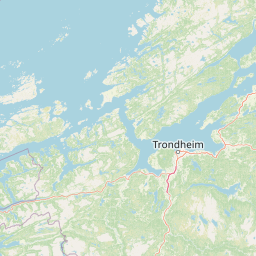
Map view of Tauterryggen

Use this park location map to pinpoint Tauterryggen in Norway, understand its exact geographic position, and read its mapped placement within the surrounding landscape more clearly.

Pigeon | © OpenStreetMap contributors
Park atlas

Compare regional marine reserves, coastal habitats, and glacial landscapes across the surrounding fjord

Explore Protected Areas and Parks Near Tauterryggen in Central Norway

Browsing other protected areas near Tauterryggen reveals diverse marine ecosystems and glacial formations across central Norway. Comparing these coastal reserves provides broader context for understanding Nordic fjord geography and underwater conservation networks.
Watercolor illustration of mountains and valleys with green and purple terrain and pink-hued peaks
National parkTrøndelag
About 59 km away#1 closest

Southeast

Skarvan and Roltdalen National Park: Protected Wilderness and Trøndelag Landscape Atlas

Explore extensive peatlands, alpine terrain, and regional geography.

The Skarvan and Roltdalen National Park detail page offers an atlas-driven exploration of this protected landscape in Norway's Trøndelag region. Discover its vast peatland systems, the intact Roltdalen valley, and its alpine environments. This page provides detailed geographic context and mapped features, highlighting the park's significance within the regional natural heritage.

Area
441.5 km²
Established
2004
IUCN
II
Relief
Mountain
National parkNorway
About 76 km away#2 closest

South

Forollhogna National Park: Norway's Gently Rolling Alpine Protected Landscape Atlas

Explore unique terrain and vital wild reindeer habitat in Central Norway.

MoriAtlas provides structured geographic context for Forollhogna National Park, Norway's nineteenth national park. This area is best known for its distinctively gentle, rolling alpine terrain, a contrast to other Norwegian mountain ranges, and as a critical habitat for wild reindeer. Discover the park's unique landscape character, its role as a protected area, and the ongoing cultural traditions tied to its mountain pastures, all visualized within a comprehensive atlas framework.

Area
1,062 km²
Established
2001
IUCN
II
Relief
Mountain
Watercolor painting showing a mountainous landscape with a waterfall, grassy fields, and wildflowers
National parkInnlandet
About 123 km away#3 closest

Southwest

Dovrefjell, Sunndalsfjella National Park: Mapping Norway's Largest Alpine Protected Landscape

Explore its protected boundaries, mountain terrain, and unique ecological significance.

Dovrefjell, Sunndalsfjella National Park is a cornerstone of Norwegian protected areas, offering an expansive alpine wilderness with dramatic mountain scenery. This page details the park's geographic context, mapped landscape features, and its importance as a refuge for unique wildlife like wild reindeer and muskox. Users can investigate the park's protected boundaries and understand its role within the regional geography of Innlandet, contributing to a structured atlas of Scandinavia's natural heritage.

Area
1,693 km²
Established
2002
IUCN
II
Relief
Mountain
National parkTrøndelag
About 147 km away#4 closest

Northeast

Blåfjella, Skjækerfjella National Park: Norway's Extensive Protected Wilderness Landscape Atlas

Mapped natural terrain and protected area boundaries in Trøndelag.

Blåfjella, Skjækerfjella National Park stands as a paramount example of Norway's commitment to preserving vast, untouched natural areas. This protected landscape in Trøndelag features expansive mountain plains, glacial valleys, and important wetland habitats, making it a significant area for understanding regional geography and biodiversity. As one of the country's largest national parks, it offers unique insights into the ecological history of spruce migration and serves as a vital sanctuary for large predators. MoriAtlas provides structured map data and geographic context to explore the protected boundaries and diverse terrain of this remarkable wilderness.

Area
1,924 km²
Established
2004
IUCN
II
Relief
Mixed relief
Watercolor painting of mountain peaks with green valleys and grassy foreground
National parkInnlandet
About 171 km away#5 closest

South

Rondane National Park: Norway's Premier Alpine Protected Landscape and Historic National Park

Mapped glacial terrain, iconic peaks, and wild reindeer sanctuary.

As Norway's first national park, Rondane offers a profound exploration of a protected alpine environment. Situated in Innlandet county, its 963 square kilometers showcase a landscape sculpted by glaciers, featuring a striking array of ten peaks exceeding 2,000 meters. This page details Rondane National Park's distinct mapped boundaries, dramatic mountain geography, and its ecological significance as a refuge for wild reindeer, making it a cornerstone of Scandinavian natural heritage.

Area
963 km²
Established
1962
IUCN
II
Relief
Mountain
National parkInnlandet
About 172 km away#6 closest

Southeast

Femundsmarka National Park: Exploring Norway's Distinctive Wetland and Boreal Protected Landscape

Mapped boundaries and regional geography in Innlandet.

Femundsmarka National Park in Innlandet, Norway, offers a profound look into a preserved wetland wilderness characterized by vast marshlands, numerous lakes, and scattered boreal forests. As a designated national park, its ecological significance is tied to the surrounding water systems and the unique landscape stretching towards the Swedish border. This entry provides detailed geographic context, mapping information, and an understanding of its protected area status, inviting exploration of its remote boreal terrain and notable wildlife habitats.

Area
573 km²
Established
1971
IUCN
II
Relief
Mixed relief
National parkInnlandet
About 174 km away#7 closest

South

Dovre National Park: Mapped Alpine Terrain & Protected Reindeer Habitat in Innlandet

Norway's protected mountain plateau landscape and wildlife corridor.

Dovre National Park is a significant protected area in Innlandet, Norway, characterized by its expansive alpine plateau terrain and role as a vital ecological corridor for wild reindeer. This national park offers users an atlas-level view of its mapped natural boundaries, focusing on the unique subarctic mountain landscape and its conservation importance. Understand Dovre National Park's geographic identity and its contribution to a contiguous network of protected lands.

Area
289 km²
Established
2003
IUCN
II
Relief
Mountain
A soft watercolor painting depicting a wide, open mountain landscape with rolling green hills, muted yellow foreground vegetation, and pale purple mountain ridges in the distance.
Protected landscapeInnlandet
About 175 km away#8 closest

South

Fokstugu landskapsvernområde: Alpine Protected Landscape and Regional Ecological Corridor

A vital bridge for mountain migration in Innlandet, Norway.

Fokstugu landskapsvernområde protects a unique mix of alpine terrain, geological formations, and cultural mountain heritage across the Dovrefjell plateau. Serving as a connective corridor between major national parks, this protected area maintains essential migratory paths for wild reindeer and preserves traditional Norwegian upland farming features.

Area
72.3 km²
Established
2002
Relief
Mountain
Climate
Alpine

Common questions about visiting, size, designation, and location context for Tauterryggen

Tauterryggen FAQs for park facts, access, geography, and protected area context

Find quick answers about Tauterryggen, including protected-area facts, park geography, trail and visitor context, and how the park fits into its surrounding country and regional landscape.
MoriAtlas Explorer

Continue Your Protected Areas Search Across the Global Atlas

Deepen your exploration by continuing the structured search for national parks and protected areas worldwide. Utilize the comprehensive filtering capabilities to compare different conservation landscapes and refine your understanding of global park geography. Discover more about the distribution and characteristics of protected natural areas.

Global natural geography