Mori Atlas logo
National parkRondane National Park

Discover the mapped terrain, dramatic peaks, and wild reindeer sanctuary of this historic Norwegian protected area.

Rondane National Park: Norway's First National Park and Iconic Alpine Protected Landscape

(Rondane nasjonalpark)

Rondane National Park, established in 1962, stands as Norway's oldest national park and a critical conservation area within Innlandet county. This protected landscape spans 963 square kilometers of dramatic alpine plateaus, featuring ten peaks over 2,000 meters, including the prominent Rondeslottet. MoriAtlas provides detailed map context and geographic insights into this unique Scandinavian wilderness, highlighting its glacial formations, iconic mountain terrain, and its role as a sanctuary for wild reindeer.

National ParkNorwayAlpine MountainsWildlife ConservationWild ReindeerHigh Mountains
Illustration of mountainous terrain with a waterfall, lake, evergreen and birch trees, and snow-capped peaks under a partly cloudy sky

Rondane National Park

National park

Park overview

Structured park overview, official facts, and landscape profile for Rondane National Park

Rondane National Park park facts, protected area profile, and essential visitor context
Review the core facts for Rondane National Park, including designation, size, terrain, visitor scale, habitats, and operating context in one park-focused overview.

About Rondane National Park

Rondane National Park occupies a distinctive position in Norway's protected area network as the nation's first national park, established in 1962 after nearly a decade of planning and advocacy. The park's creation marked a pivotal moment in Norwegian conservation history, setting a precedent for the protection of mountain ecosystems and cultural landscapes. The park's territory spans seven municipalities in Innlandet county: Dovre, Folldal, Sel, Nord-Fron, Sør-Fron, Stor-Elvdal, and Ringebu, creating a collaborative governance framework that reflects the mountain region's traditional connection to surrounding communities.

The park's central massif rises dramatically from the Gudbrandsdalen valley, presenting a landscape of stark alpine beauty where bare rock and permanent snow fields dominate the higher elevations. Below approximately 1,500 meters, the mountains transition to heath-covered plateaus and eventually to birch forest at the tree line. The combination of aridity, harsh winters, and nutrient-poor soils has created an ecosystem of remarkable resilience and specialization, where only the hardiest species can survive.

The 2003 expansion of the park nearly doubled its original area, adding critical habitat for the wild reindeer population that represents one of the last remaining herds of truly wild reindeer in Europe. This expansion also connected the park more effectively to the broader network of protected mountain areas, including the nearby Dovre National Park to the north, creating a contiguous conservation landscape that supports long-term ecological viability.

Quick facts and research context for Rondane National Park

Rondane is situated in Innlandet county, Norway, just east of the Gudbrandsdalen valley. The park contains Norway's highest concentration of peaks above 2,000 meters within a single protected area, with Rondeslottet as the tallest at 2,178 meters. The tree line sits at approximately 1,000 to 1,100 meters above sea level. The park was originally established in 1962 covering 580 km² and was significantly expanded in 2003 to nearly double its size, primarily to strengthen protections for the wild reindeer population estimated at 2,000 to 4,000 individuals. The park is motor traffic-free and managed by the Norwegian Directorate for Nature Management.

Park context

Deeper park guide and search-rich context for Rondane National Park

Rondane National Park history, landscape, wildlife, and travel context
Explore Rondane National Park through its history, landscape character, ecosystems, wildlife, conservation priorities, cultural context, and seasonal travel timing in a structured park guide built for atlas discovery and search intent.

Why Rondane National Park stands out

Rondane is best known as Norway's first national park and as a critical sanctuary for Europe's last wild reindeer herds. The park's dramatic alpine scenery, with its sharp peaks rising abruptly from glacial valleys, represents one of Scandinavia's most iconic mountain landscapes. The massif features a distinctive cluster of ten summits exceeding 2,000 meters, including the photogenic Rondeslottet and Storronden, which can all be reached from the central lake Rondvatnet within a single day's hike. The cultural legacy of the park is equally significant, having inspired Henrik Ibsen's Peer Gynt and serving as a symbol of Norwegian wilderness in literature and folklore.

A landscape view of snow-capped mountains with a clear blue sky, forested foothills, and wildflowers in the foreground
Snow-capped mountains in Rondane National Park, Norway

Rondane National Park history and protected-area timeline

The history of human activity in Rondane extends back thousands of years, with archaeological evidence revealing a long tradition of reindeer hunting in the high mountains. Stone traps and drive lanes used to capture reindeer have been found at sites including Gravhø and Bløyvangen, some dating back approximately 3,500 years. These sophisticated hunting installations, combined with smaller stone structures believed to be archers' blinds, demonstrate that prehistoric hunters systematically exploited the seasonal movements of reindeer herds through the mountain valleys.

The majority of archaeological discoveries in the park, including residential ruins, date from the period between 500 and 700 AD, indicating sustained human presence during the Viking Age. The large stone traps remained in use from the 6th century until the Black Death devastated Scandinavian populations in the 14th century, after which the high mountain areas were largely abandoned.

The modern protection of Rondane began with Norway's nature protection law of 1954, which established the legal framework for creating protected areas. Community meetings in municipalities surrounding Rondane followed in 1955, leading to the formation of a commission that would champion the park's establishment. Norman Heitkøtter chaired this commission, which successfully secured Royal resolution establishing Rondane as Norway's first national park on 21 December 1962. The original park covered 580 km², though this was nearly doubled in 2003 as part of expanded protections for wild reindeer.

Rondane National Park landscape and geographic character

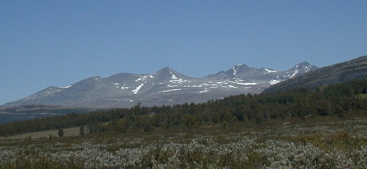
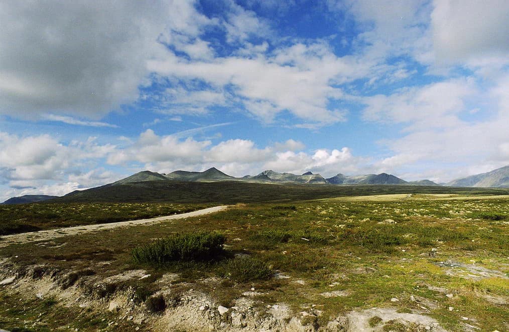
Rondane presents a quintessential high-mountain landscape characterized by extensive plateaus, steep-walled valleys, and dramatic peaks that rise abruptly from the surrounding terrain. The park contains ten summits exceeding 2,000 meters, with the highest point being Rondeslottet at 2,178 meters, followed by Storronden at 2,138 meters and Høgronden at 2,114 meters. The name Rondane derives from the word "rond," referring to the narrow lake Rondvatnet that occupies a dramatic position between the central peaks.

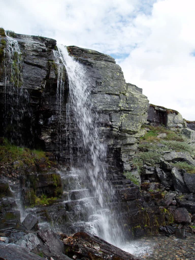
The terrain is marked by deep valleys carved by glacial activity during the last ice age, which ended approximately 9,000 to 10,000 years ago. Among the most prominent geological features is Jutulhogget, a dramatic canyon formed by the rapid melting of glacial ice. The landscape also displays numerous kettle holes, which are depressions left by melting ice blocks, and distinctive eskers, which are ridges of glacial moraine deposited by streams flowing beneath ancient glaciers.

The central lake Rondvatnet sits in a steep valley between the Storronden-Rondeslottet massif and Smiubelgen, creating a natural amphitheater surrounded by the park's highest peaks. Below the peaks, "botns" are flat, stone-filled valleys that lie beneath the steep mountain walls. The absence of significant glaciers is notable; while the climate does not support permanent ice, glacier-like snow fields persist in some of the sheltered back valleys.

Panoramic view of Rondane National Park featuring mountain peaks, a lake, and forested terrain under a cloudy sky.
Panorama of Rondane National Park's central massif showing peaks including Storronden, Rondslottet, and Digerronden.

Rondane National Park ecosystems, habitats, and plant life

The ecological character of Rondane is defined by harsh alpine conditions that have produced a landscape of remarkable ecological specialization. The climate is relatively arid for a mountainous area in Norway, and the thin, nutrient-poor soils support only the most resilient vegetation. Below the tree line at approximately 1,000 to 1,100 meters, white birch forest represents the dominant woodland, while the higher elevations are covered primarily by heather and lichen communities.

The alpine zone above 1,500 meters is almost entirely devoid of vascular plants, with only the hardiest lichens surviving on the bare rock surfaces. This harsh environment, while appearing barren to casual observation, actually supports a specialized food web centered on the reindeer that graze the lichen and heather communities. The lichen not only provide direct nutrition for the reindeer but also contribute to soil formation, enabling other plants to establish in what would otherwise be sterile substrate.

The park's position as an important watershed is reflected in its network of streams and the central Rondvatnet, which drains into the larger Gudbrandsdalen river system. The combination of geological age, limited glaciation, and long-term protection has allowed the ecosystem to develop characteristics found nowhere else in Norway.

Panoramic view of a lake bordered by dense forests with autumn foliage, snow-capped mountains in the background under a clear blue sky
Lake Atnsjøen surrounded by snow-capped mountains and autumn-colored forests in Rondane National Park

Rondane National Park wildlife and species highlights

Rondane is home to one of the last truly wild reindeer populations in Europe, representing a conservation priority of international significance. The park supports an estimated 2,000 to 4,000 wild reindeer, which the Norwegian Directorate for Nature Management considers "especially important as a life supporting area for the native reindeer." These reindeer are the wild ancestors of domestic reindeer, not simply feral descendants, making them genetically and ecologically distinct.

The reindeer rely primarily on lichen and reindeer moss that grow amid heather and hardy grasses on the arid plateaus. This food source is critical not only for the reindeer but also for the small mammals that inhabit the ecosystem, including mice and lemmings, which in turn support predator populations. The park also supports populations of larger mammals including roe deer and elk, which are commonly found along the forest edges bordering the park. Occasionally, musk ox from the neighboring Dovre area venture into Rondane, representing one of the few places where this ancient Arctic species can be observed in Norway.

The predator community includes wolverines, lynxes, and a small population of brown bears, while wolves are rarely observed. The Glacier Crowfoot flower represents one of the few plant species that thrives at higher elevations, found up to 1,700 meters.

Wide view of open tundra landscape with distant mountain peaks under partly cloudy sky
Wide view of open terrain and distant mountain peaks in Rondane National Park

Rondane National Park conservation status and protection priorities

Rondane National Park holds exceptional conservation significance as one of the last strongholds of wild reindeer in Europe. The 2003 expansion of the park was specifically designed to provide enhanced protection for this endangered population, nearly doubling the protected area to create more extensive habitat connectivity. The protection of core reindeer areas has been so prioritized that hiking trails have been rerouted to minimize disturbance during critical seasons.

The park's conservation value extends beyond the reindeer to encompass the entire alpine ecosystem, including the unique lichen-heath communities that characterize the high plateaus. The absence of significant industrial development, the prohibition of motor vehicles, and the relatively light visitor impact have all contributed to maintaining the ecological integrity of the landscape. The designation of adjacent Dovre National Park and the broader network of protected mountain areas in the Dovrefjell-Sunndalsfjella region creates a conservation landscape of international importance.

As Norway's first national park, Rondane also carries significant institutional and historical conservation value, representing the nation's commitment to preserving its natural heritage for future generations.

Rondane National Park cultural meaning and human context

Rondane has held a significant place in Norwegian cultural consciousness for centuries, appearing in folklore, literature, and as a symbol of Norwegian wilderness. The mountains feature prominently in Henrik Ibsen's play Peer Gynt (1867), where Act II is set "among the Ronde mountains" during sunset, with the protagonist encountering "glittering gate" and drifting towers. This literary association has made Rondane one of the most recognizable mountain landscapes in Norwegian culture.

The folklorist Peter Christen Asbjørnsen collected numerous stories connected with the Rondane region during the mid-19th century, including the tales that would inspire Ibsen's Peer Gynt. The poet Aasmund Olavsson Vinje also drew inspiration from the mountains, composing verses such as "Ved Rundane" that celebrated the dramatic landscape.

Archaeological evidence reveals that the mountains supported human communities for thousands of years, with prehistoric reindeer hunters establishing sophisticated drive systems to harvest migrating herds. The continuity of human connection to this landscape, from Stone Age hunters through Viking Age settlements to modern conservation, adds depth to the park's cultural significance.

Brown cattle walking through a shallow stream in a grassy valley with mountain peaks in the background
Grimsdalen valley in Rondane National Park with cattle crossing a stream

Top sights and standout views in Rondane National Park

Rondane offers visitors access to some of Norway's most dramatic alpine scenery, with the iconic peaks of Rondeslottet and Storronden rising above the central lake Rondvatnet. The park's network of DNT mountain cabins, including staffed Rondvassbu, Dørålseter, and Bjørnhollia, provides base camps for exploration, while red T-marked trails ensure safe navigation. The opportunity to observe wild reindeer in their natural habitat represents one of the most significant wildlife experiences available in European protected areas. The literary heritage connecting the park to Ibsen's Peer Gynt adds a cultural dimension that distinguishes Rondane from other Scandinavian mountain parks. The absence of motor traffic creates a peaceful wilderness atmosphere, while the proximity to the Gudbrandsdalen valley provides convenient access for visitors exploring central Norway.

Waterfall flowing down rocky cliffs with moss-covered rocks and scattered boulders under a partly cloudy sky
Waterfall cascading down rocky cliffs in Rondane National Park

Best time to visit Rondane National Park

The optimal time to visit Rondane depends on the type of experience sought. The summer months of June through September offer the most accessible conditions for hiking, with snow-free trails and relatively mild temperatures in the valleys. July and August typically provide the warmest conditions and longest days, though the high mountains can still experience cold conditions and snow. The shoulder seasons of June and September offer fewer visitors and the possibility of more solitude, though weather conditions become less predictable.

Winter access is possible but requires appropriate alpine experience and equipment, as the park transforms into a challenging ski touring destination. The staffed cabins remain open during winter and offer cross-country skiing opportunities on marked trails. The stark beauty of the snow-covered peaks and the possibility of observing wildlife tracks in fresh snow appeals to experienced winter visitors. The aurora borealis season from late autumn through early spring provides another dimension to winter visits for those willing to brave the cold.

Park location guide

Geography guide, regional context, and park location map for Rondane National Park

Rondane National Park park geography, regions, and map view in Norway
Understand where Rondane National Park sits in Norway through a broader geographic reading of the surrounding landscape, nearby location context, and its mapped position within the national park landscape.

How Rondane National Park fits into Norway

Norway, officially the Kingdom of Norway, is a Nordic country in Northern Europe located on the Scandinavian Peninsula. It encompasses mainland Norway, the Arctic islands of Svalbard and Jan Mayen, and maintains dependencies including Bouvet Island and Antarctic claims. The country has a population of about 5.6 million and is bordered by Sweden, Finland, and Russia. Norway is a unitary parliamentary constitutional monarchy with Oslo as its capital and largest city.

Wider geography shaping Rondane National Park in Norway

Norway occupies the western and northern portions of the Scandinavian Peninsula in Northern Europe. The country shares a long eastern border with Sweden, and borders Finland and Russia to the northeast. Norway has an extensive coastline facing the Skagerrak, North Sea, Norwegian Sea, and Barents Sea. The terrain is predominantly mountainous with numerous fjords along the coastline.

Map view of Rondane National Park

Use this park location map to pinpoint Rondane National Park in Norway, understand its exact geographic position, and read its mapped placement within the surrounding landscape more clearly.

Pigeon | © OpenStreetMap contributors

Location context for Rondane National Park

Innlandet

Explore the visual character of Scandinavia's pristine high-mountain wilderness, tracing its glacial terrain, unique ecosystems, and iconic peaks.

Rondane National Park: Iconic High-Mountain Landscapes, Glacial Terrain, and Wild Reindeer Habitats in Visual Detail
Explore photography of Rondane National Park, revealing its dramatic alpine plateaus, high mountain peaks, and deep glacial valleys that characterize Norway's oldest protected area. These images offer crucial visual context, enhancing understanding of the park's distinctive terrain, vital wild reindeer habitats, and unique conservation landscape.

A landscape view of snow-capped mountains with a clear blue sky, forested foothills, and wildflowers in the foreground

Snow-capped mountains reflecting in a calm lake with patches of snow on the shore and a clear blue sky

Panoramic view of Rondane National Park featuring mountain peaks, a lake, and forested terrain under a cloudy sky.

Panoramic view of a lake bordered by dense forests with autumn foliage, snow-capped mountains in the background under a clear blue sky

Wide view of open tundra landscape with distant mountain peaks under partly cloudy sky

A dirt path through a grassy field with rolling hills and mountains under a partly cloudy sky.

Brown cattle walking through a shallow stream in a grassy valley with mountain peaks in the background

Waterfall flowing down rocky cliffs with moss-covered rocks and scattered boulders under a partly cloudy sky

Park atlas

Trace the mapped geography and compare other protected areas within Norway's high-mountain regions.

Discover Adjacent National Parks and Protected Areas Near Rondane National Park
Browse other national parks and protected areas in Norway, focusing on nearby destinations and similar high-mountain landscapes surrounding Rondane National Park. Compare distinct park characteristics, trace regional conservation efforts, and understand the broader geographic context of Scandinavia's protected wild reindeer habitats.
National parkInnlandet

Dovre National Park: Mapped Alpine Terrain & Protected Reindeer Habitat in Innlandet

Norway's protected mountain plateau landscape and wildlife corridor.

Dovre National Park is a significant protected area in Innlandet, Norway, characterized by its expansive alpine plateau terrain and role as a vital ecological corridor for wild reindeer. This national park offers users an atlas-level view of its mapped natural boundaries, focusing on the unique subarctic mountain landscape and its conservation importance. Understand Dovre National Park's geographic identity and its contribution to a contiguous network of protected lands.

Area
289 km²
Established
2003
IUCN
II
Relief
Mountain
Watercolor painting showing a mountainous landscape with a waterfall, grassy fields, and wildflowers
National parkInnlandet

Dovrefjell, Sunndalsfjella National Park: Mapping Norway's Largest Alpine Protected Landscape

Explore its protected boundaries, mountain terrain, and unique ecological significance.

Dovrefjell, Sunndalsfjella National Park is a cornerstone of Norwegian protected areas, offering an expansive alpine wilderness with dramatic mountain scenery. This page details the park's geographic context, mapped landscape features, and its importance as a refuge for unique wildlife like wild reindeer and muskox. Users can investigate the park's protected boundaries and understand its role within the regional geography of Innlandet, contributing to a structured atlas of Scandinavia's natural heritage.

Area
1,693 km²
Established
2002
IUCN
II
Relief
Mountain
Watercolor illustration of a mountain range with green hills and a lake in the foreground
National park

Jotunheimen National Park: Norway's Iconic Alpine Protected Landscape and Geographic Core

Explore mapped glacial terrain and alpine geography.

Jotunheimen National Park stands as a monument to Norway's alpine grandeur, protecting over 1,151 square kilometers of spectacular mountainous terrain. This protected area is defined by its dramatic glacial features, including sharp peaks exceeding 1,900 meters, U-shaped valleys, and pristine alpine lakes, making it a significant focus for geographic exploration and mapped landscape study. Delve into the core of Norway's mountain heartland, understanding the mapped boundaries and regional geological context that shape this iconic protected landscape.

Area
1,151 km²
Established
1980
IUCN
II
Relief
Mountain
National parkInnlandet

Langsua National Park: Protected Mountain Forests and Inland Wilderness in Innlandet, Norway

Discover mapped boundaries and regional geographic context.

Langsua National Park, a designation expanded in 2011, is a prominent protected area in Norway's Innlandet county. This national park encompasses 537.1 square kilometers of diverse mountainous terrain, characterized by extensive mountain forests and inland wilderness habitats. Its creation consolidates fragmented nature reserves into a significant contiguous protected landscape, offering valuable insight into Norway's conservation strategies and the geographic context of its eastern mountain regions.

Area
537.1 km²
Established
2011
IUCN
II
Relief
Mixed relief
National parkInnlandet

Reinheimen National Park: Norway's Vast Protected Wilderness Landscape and Alpine Geography

Map of protected boundaries and diverse mountain terrain.

Reinheimen National Park is a cornerstone of Norway's protected areas, encompassing a substantial portion of Western Norway's alpine wilderness. This national park protects a dynamic landscape characterized by dramatic western peaks and gentler eastern plateaus, providing critical habitat for wild reindeer and other wildlife. Its extensive mapped boundaries and varied natural terrain offer a rich subject for geographic discovery and atlas exploration, highlighting the ecological significance of well-preserved mountain ecosystems within Innlandet.

Area
1,969 km²
Established
2006
IUCN
II
Relief
Mountain
National park

Forollhogna National Park: Norway's Gently Rolling Alpine Protected Landscape Atlas

Explore unique terrain and vital wild reindeer habitat in Central Norway.

MoriAtlas provides structured geographic context for Forollhogna National Park, Norway's nineteenth national park. This area is best known for its distinctively gentle, rolling alpine terrain, a contrast to other Norwegian mountain ranges, and as a critical habitat for wild reindeer. Discover the park's unique landscape character, its role as a protected area, and the ongoing cultural traditions tied to its mountain pastures, all visualized within a comprehensive atlas framework.

Area
1,062 km²
Established
2001
IUCN
II
National parkInnlandet

Breheimen National Park: Protected Glacial Landscapes and Mountain Terrain in Innlandet

Norway's prominent national park featuring active glaciers and alpine geography.

Breheimen National Park represents a significant protected landscape within Norway's Innlandet region, dedicated to conserving its unique glacial formations and dramatic alpine terrain. The park's vast area encompasses active glaciers, soaring peaks, and a notable diversity of natural environments, from lush valleys to barren plateaus. MoriAtlas facilitates a detailed exploration of Breheimen National Park, highlighting its mapped protected boundaries and its integral role in the regional geography and protected areas atlas.

Area
1,671 km²
Established
2009
IUCN
II
Relief
Mountain
National parkVestland

Jostedalsbreen National Park: Europe's Premier Glacial Protected Landscape

Mapped terrain and protected area discovery in Vestland, Norway.

Jostedalsbreen National Park represents a unique geographic entity, safeguarding the largest glacier on the European mainland. This national park, situated in Norway's Vestland region, offers profound insights into glacial landscapes and mountain geography. Users can explore the vast ice mass that dominates the terrain, observe the U-shaped valleys carved by its movement, and understand the geological processes shaping this dynamic environment. The park's protected status highlights its importance for understanding glacial science and preserving a critical component of Norway's natural heritage.

Area
1,310 km²
Established
1991
IUCN
II
Relief
Mountain

Common questions about visiting, size, designation, and location context for Rondane National Park

Rondane National Park FAQs for park facts, access, geography, and protected area context
Find quick answers about Rondane National Park, including protected-area facts, park geography, trail and visitor context, and how the park fits into its surrounding country and regional landscape.
MoriAtlas Explorer

Continue Your Protected Areas Search Across the Global Atlas

Deepen your exploration by continuing the structured search for national parks and protected areas worldwide. Utilize the comprehensive filtering capabilities to compare different conservation landscapes and refine your understanding of global park geography. Discover more about the distribution and characteristics of protected natural areas.

Global natural geography