Mori Atlas logo
National parkLangsua National Park

Discover the mapped boundaries and geographic context of this protected area in Eastern Norway.

Langsua National Park: Norway's Expansive Mountain Forest Protected Landscape in Innlandet

Langsua National Park, established in 2011, represents a key protected landscape in Norway's Innlandet county. Covering 537.1 square kilometers of mountainous terrain, it preserves extensive mountain forest ecosystems and inland wilderness. This national park integrates multiple nature reserves into a cohesive conservation area, offering a unique opportunity to explore Norway's contiguous protected lands and their regional geographic significance through an atlas lens.

national parksNorwayInnlandetmountain forestsprotected areasEastern Norway

Langsua National Park

National park

Park overview

Structured park overview, official facts, and landscape profile for Langsua National Park

Langsua National Park park facts, protected area profile, and essential visitor context
Review the core facts for Langsua National Park, including designation, size, terrain, visitor scale, habitats, and operating context in one park-focused overview.

About Langsua National Park

Langsua National Park was established in 2011 as a major addition to Norway's network of protected areas, representing an expansion of the original Ormtjernkampen National Park from 1968. The park covers a substantial area of 537.1 square kilometres in the mountainous interior of eastern Norway, making it one of the more significant recent additions to Norway's national park estate. The protected area encompasses parts of six municipalities across Innlandet county, reflecting a collaborative approach to landscape conservation that recognizes the ecological continuity of mountain forest ecosystems that span administrative boundaries. The park sits within a broader complex of protected areas, with adjacent nature reserves and landscape protection areas extending the conservation network across a total area exceeding 1,000 square kilometres. This connected approach to protection helps preserve ecological corridors and maintains landscape integrity across a region characterized by forests, wetlands, and mountainous terrain.

Quick facts and research context for Langsua National Park

Langsua National Park is located in Innlandet county in eastern Norway, with the nearest major settlement being Lillehammer. The park covers 537.1 km² and was established on 11 March 2011 as an expansion of the 1968 Ormtjernkampen National Park. It spans six municipalities across Norway's mountainous interior. The park forms part of a larger protected-area complex that includes several nature reserves and landscape protection areas, creating a contiguous conservation landscape of over 1,000 km². The area is classified under IUCN category II as a national park.

Park context

Deeper park guide and search-rich context for Langsua National Park

Langsua National Park history, landscape, wildlife, and travel context
Explore Langsua National Park through its history, landscape character, ecosystems, wildlife, conservation priorities, cultural context, and seasonal travel timing in a structured park guide built for atlas discovery and search intent.

Why Langsua National Park stands out

Langsua National Park is known for its extensive mountain forest ecosystems and its role in protecting Norway's inland wilderness areas. The park represents one of the larger contiguous protected landscapes in eastern Norway, connecting multiple nature reserves and landscape protection areas into a unified conservation network. It preserves the ecological character of the mountain regions in what was historically a significant expansion of Norway's national park system, extending protection to forest and mountain habitats that had previously received only fragmented conservation status.

Mountain landscape with turquoise lakes, snow-covered peaks, rocky slopes, and a river flowing through a valley under a partly cloudy sky
Panoramic view from Knutshøi towards Jotunheimen, showcasing turquoise lakes, snow-capped peaks, and rocky mountain slopes under a partly cloudy sky

Langsua National Park history and protected-area timeline

Langsua National Park was formally established on 11 March 2011, representing the culmination of efforts to expand conservation protection in Norway's mountain regions. The park was created as a significant extension of the existing Ormtjernkampen National Park, which was established in 1968. This expansion reflected a growing recognition of the ecological importance of mountain forest ecosystems in eastern Norway and the need for more comprehensive protection of these landscapes. The establishment of Langsua as a national park also incorporated surrounding nature reserves and landscape protection areas into a more unified conservation framework, creating a coherent protected landscape spanning multiple municipalities.

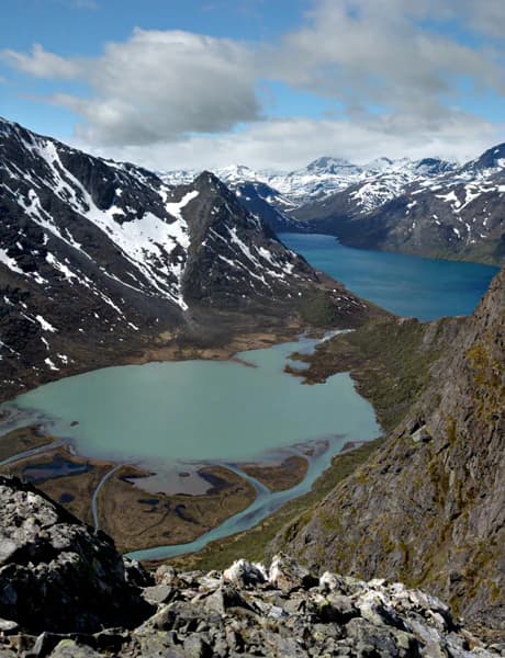
Top sights and standout views in Langsua National Park

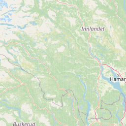
Langsua National Park represents a significant expansion of Norwegian protected-area networks in the mountain forest regions of eastern Norway. The park's creation in 2011 as an extension of the older Ormtjernkampen National Park demonstrates Norway's approach to consolidating fragmented protection into coherent national park designations. The park's location in Innlandet county places it within one of Norway's most extensive contiguous wilderness areas, where forest and mountain ecosystems remain relatively intact. The protection of this landscape supports biodiversity conservation in a region where sustainable management of mountain forests has been an ongoing priority.

Park location guide

Geography guide, regional context, and park location map for Langsua National Park

Langsua National Park park geography, regions, and map view in Norway
Understand where Langsua National Park sits in Norway through a broader geographic reading of the surrounding landscape, nearby location context, and its mapped position within the national park landscape.

How Langsua National Park fits into Norway

Norway, officially the Kingdom of Norway, is a Nordic country in Northern Europe located on the Scandinavian Peninsula. It encompasses mainland Norway, the Arctic islands of Svalbard and Jan Mayen, and maintains dependencies including Bouvet Island and Antarctic claims. The country has a population of about 5.6 million and is bordered by Sweden, Finland, and Russia. Norway is a unitary parliamentary constitutional monarchy with Oslo as its capital and largest city.

Wider geography shaping Langsua National Park in Norway

Norway occupies the western and northern portions of the Scandinavian Peninsula in Northern Europe. The country shares a long eastern border with Sweden, and borders Finland and Russia to the northeast. Norway has an extensive coastline facing the Skagerrak, North Sea, Norwegian Sea, and Barents Sea. The terrain is predominantly mountainous with numerous fjords along the coastline.

Map view of Langsua National Park

Use this park location map to pinpoint Langsua National Park in Norway, understand its exact geographic position, and read its mapped placement within the surrounding landscape more clearly.

Pigeon | © OpenStreetMap contributors

Location context for Langsua National Park

Innlandet

Browse imagery revealing the diverse terrain, unique habitats, and preserved wilderness character within this expansive Norwegian protected area.

Explore Langsua National Park Photos: Visualizing Mountain Forest Landscapes and Protected Scenery
Visually explore the rugged mountain forests, expansive wetlands, and serene valleys that define Langsua National Park's distinctive natural environment and protected landscapes. Understanding the park's visual identity through these images provides crucial insight into its ecological character, geographical spread, and conservation significance in eastern Norway.

Mountain landscape with turquoise lakes, snow-covered peaks, rocky slopes, and a river flowing through a valley under a partly cloudy sky

Wooden shelter with snow-covered roof surrounded by snow in a mountainous landscape

Park atlas

Trace the protected landscapes of Eastern Norway and explore regional park geography beyond Langsua National Park.

Discover Other National Parks and Protected Areas Near Langsua National Park
After exploring Langsua National Park, browse other national parks and protected areas in Eastern Norway, mapping their locations within the extensive mountain forest ecosystems of Innlandet county. Compare the varied conservation landscapes, trace connected protected land networks, and discover additional protected areas that contribute to Norway's significant inland wilderness.
Watercolor illustration of a mountain range with green hills and a lake in the foreground
National park

Jotunheimen National Park: Norway's Iconic Alpine Protected Landscape and Geographic Core

Explore mapped glacial terrain and alpine geography.

Jotunheimen National Park stands as a monument to Norway's alpine grandeur, protecting over 1,151 square kilometers of spectacular mountainous terrain. This protected area is defined by its dramatic glacial features, including sharp peaks exceeding 1,900 meters, U-shaped valleys, and pristine alpine lakes, making it a significant focus for geographic exploration and mapped landscape study. Delve into the core of Norway's mountain heartland, understanding the mapped boundaries and regional geological context that shape this iconic protected landscape.

Area
1,151 km²
Established
1980
IUCN
II
Relief
Mountain
Watercolor painting of mountain peaks with green valleys and grassy foreground
National parkInnlandet

Rondane National Park: Norway's Premier Alpine Protected Landscape and Historic National Park

Mapped glacial terrain, iconic peaks, and wild reindeer sanctuary.

As Norway's first national park, Rondane offers a profound exploration of a protected alpine environment. Situated in Innlandet county, its 963 square kilometers showcase a landscape sculpted by glaciers, featuring a striking array of ten peaks exceeding 2,000 meters. This page details Rondane National Park's distinct mapped boundaries, dramatic mountain geography, and its ecological significance as a refuge for wild reindeer, making it a cornerstone of Scandinavian natural heritage.

Area
963 km²
Established
1962
IUCN
II
Relief
Mountain
National parkInnlandet

Dovre National Park: Mapped Alpine Terrain & Protected Reindeer Habitat in Innlandet

Norway's protected mountain plateau landscape and wildlife corridor.

Dovre National Park is a significant protected area in Innlandet, Norway, characterized by its expansive alpine plateau terrain and role as a vital ecological corridor for wild reindeer. This national park offers users an atlas-level view of its mapped natural boundaries, focusing on the unique subarctic mountain landscape and its conservation importance. Understand Dovre National Park's geographic identity and its contribution to a contiguous network of protected lands.

Area
289 km²
Established
2003
IUCN
II
Relief
Mountain
Abstract watercolor landscape with soft pastel hues of green, pink, yellow, and purple
National park

Hallingskarvet National Park: Norway's High Mountain Plateau and Protected Wilderness

Mapping glacial terrain, alpine environments, and wild reindeer habitat.

Hallingskarvet National Park offers a unique window into Norway's geological history and alpine ecology. This protected landscape encompasses the striking Hallingskarvet plateau and the Vargebreen glacier, along with deep valleys carved by ancient ice. Users can explore the park's mapped boundaries, understand its regional geographic setting in Scandinavia, and appreciate its conservation value as a habitat for wild reindeer. The park's terrain provides a concrete example of glacial shaping and high-altitude ecosystems within the Nordic context.

Area
450 km²
Established
2006
IUCN
II
Relief
Mountain
National parkInnlandet

Reinheimen National Park: Norway's Vast Protected Wilderness Landscape and Alpine Geography

Map of protected boundaries and diverse mountain terrain.

Reinheimen National Park is a cornerstone of Norway's protected areas, encompassing a substantial portion of Western Norway's alpine wilderness. This national park protects a dynamic landscape characterized by dramatic western peaks and gentler eastern plateaus, providing critical habitat for wild reindeer and other wildlife. Its extensive mapped boundaries and varied natural terrain offer a rich subject for geographic discovery and atlas exploration, highlighting the ecological significance of well-preserved mountain ecosystems within Innlandet.

Area
1,969 km²
Established
2006
IUCN
II
Relief
Mountain
Watercolor painting showing a mountainous landscape with a waterfall, grassy fields, and wildflowers
National parkInnlandet

Dovrefjell, Sunndalsfjella National Park: Mapping Norway's Largest Alpine Protected Landscape

Explore its protected boundaries, mountain terrain, and unique ecological significance.

Dovrefjell, Sunndalsfjella National Park is a cornerstone of Norwegian protected areas, offering an expansive alpine wilderness with dramatic mountain scenery. This page details the park's geographic context, mapped landscape features, and its importance as a refuge for unique wildlife like wild reindeer and muskox. Users can investigate the park's protected boundaries and understand its role within the regional geography of Innlandet, contributing to a structured atlas of Scandinavia's natural heritage.

Area
1,693 km²
Established
2002
IUCN
II
Relief
Mountain
National parkInnlandet

Breheimen National Park: Protected Glacial Landscapes and Mountain Terrain in Innlandet

Norway's prominent national park featuring active glaciers and alpine geography.

Breheimen National Park represents a significant protected landscape within Norway's Innlandet region, dedicated to conserving its unique glacial formations and dramatic alpine terrain. The park's vast area encompasses active glaciers, soaring peaks, and a notable diversity of natural environments, from lush valleys to barren plateaus. MoriAtlas facilitates a detailed exploration of Breheimen National Park, highlighting its mapped protected boundaries and its integral role in the regional geography and protected areas atlas.

Area
1,671 km²
Established
2009
IUCN
II
Relief
Mountain
National parkVestland

Jostedalsbreen National Park: Europe's Premier Glacial Protected Landscape

Mapped terrain and protected area discovery in Vestland, Norway.

Jostedalsbreen National Park represents a unique geographic entity, safeguarding the largest glacier on the European mainland. This national park, situated in Norway's Vestland region, offers profound insights into glacial landscapes and mountain geography. Users can explore the vast ice mass that dominates the terrain, observe the U-shaped valleys carved by its movement, and understand the geological processes shaping this dynamic environment. The park's protected status highlights its importance for understanding glacial science and preserving a critical component of Norway's natural heritage.

Area
1,310 km²
Established
1991
IUCN
II
Relief
Mountain

Common questions about visiting, size, designation, and location context for Langsua National Park

Langsua National Park FAQs for park facts, access, geography, and protected area context
Find quick answers about Langsua National Park, including protected-area facts, park geography, trail and visitor context, and how the park fits into its surrounding country and regional landscape.
MoriAtlas Explorer

Continue Your Protected Areas Search Across the Global Atlas

Deepen your exploration by continuing the structured search for national parks and protected areas worldwide. Utilize the comprehensive filtering capabilities to compare different conservation landscapes and refine your understanding of global park geography. Discover more about the distribution and characteristics of protected natural areas.

Global natural geography