Mori Atlas logo
National parkTel Be'er Sheva National Park

Discover the mapped boundaries and natural terrain of this national park in the heart of Israel.

Tel Be'er Sheva National Park: Protected Landscape and Geographic Context in Israel

Tel Be'er Sheva National Park stands as a distinct protected landscape within the geography of Israel. This page offers an atlas-driven exploration of its mapped boundaries and natural terrain, providing essential context for understanding its place within the country's protected areas. Delve into the specific geographic features and landscape character that define this significant national park for a clearer picture of its regional significance.

archaeological sitedesert landscapebiblical historyancient ruinsnational parkNegev Desert

Tel Be'er Sheva National Park

National park

Park overview

Structured park overview, official facts, and landscape profile for Tel Be'er Sheva National Park

Tel Be'er Sheva National Park park facts, protected area profile, and essential visitor context

Review the core facts for Tel Be'er Sheva National Park, including designation, size, terrain, visitor scale, habitats, and operating context in one park-focused overview.

About Tel Be'er Sheva National Park

Tel Be'er Sheva National Park encompasses an archaeological tel located in the arid Negev region of southern Israel. The site has been identified with the biblical city of Be'er Sheva and contains layers of occupation spanning different historical periods. Archaeological excavations have revealed remains including residential structures, public buildings, and water collection systems that demonstrate the sophisticated engineering and settlement patterns of ancient inhabitants. The park provides a window into the history of this desert frontier region and its importance as a settlement and trade corridor in antiquity. Visitors can observe the archaeological remains while learning about the site's historical significance through interpretive displays and guided areas.

Quick facts and research context for Tel Be'er Sheva National Park

Tel Be'er Sheva is an archaeological site located in the Negev Desert in southern Israel, approximately 4 kilometers east of modern Be'er Sheva. The site features ancient ruins including structures from the Israelite period, well-preserved water cisterns, and remains of settlements that date back centuries. The national park provides controlled access to the archaeological remains, preserving this historical and cultural heritage site within the desert landscape.

Protection and recognition

Exploring official conservation boundaries and registered designation history for the protected area

Documented Protection Status and Designations of Tel Be'er Sheva National Park

Verified conservation datasets outline the officially documented protection status and management scope established for Tel Be'er Sheva National Park. Aggregated designation details and international conservation frameworks provide clear geographic context for researchers tracking global protected landscapes.

Protection details

Transboundary protection
No
Park context

Deeper park guide and search-rich context for Tel Be'er Sheva National Park

Tel Be'er Sheva National Park history, landscape, wildlife, and travel context

Explore Tel Be'er Sheva National Park through its history, landscape character, ecosystems, wildlife, conservation priorities, cultural context, and seasonal travel timing in a structured park guide built for atlas discovery and search intent.

Why Tel Be'er Sheva National Park stands out

Tel Be'er Sheva is best known for its well-preserved archaeological ruins from ancient settlement periods, particularly the Israelite era. The site features ruins of ancient buildings, water infrastructure, and defensive structures that provide insight into daily life in this desert region during antiquity. The combination of archaeological significance and its setting at the edge of the Negev Desert makes it a notable destination for those interested in ancient history and biblical archaeology.

Tel Be'er Sheva National Park history and protected-area timeline

The history of Tel Be'er Sheva stretches back to antiquity, with the site serving as an important settlement in the Negev region. The location is mentioned in biblical texts, connecting it to the history of ancient Israel. Over the centuries, various peoples occupied the site, each leaving layers of construction and modification. The archaeological record at Tel Be'er Sheva provides evidence of continuous or recurring habitation despite the challenging desert environment, largely due to the availability of water sources in the area. The establishment of the site as a national park reflects Israel's commitment to preserving its archaeological heritage and making historical sites accessible for education and appreciation.

Tel Be'er Sheva National Park landscape and geographic character

The landscape of Tel Be'er Sheva is characteristic of the northern Negev Desert, featuring arid terrain with sparse vegetation and geological formations typical of this semi-arid region. The tel itself rises slightly above the surrounding plain, created by centuries of accumulated sediment and construction materials. The area experiences a desert climate with limited rainfall, making water conservation historically crucial for settlement. The surrounding landscape includes the broad Be'er Sheva valley, which provides context for why this location was chosen for settlement despite the challenging environmental conditions.

Tel Be'er Sheva National Park ecosystems, habitats, and plant life

The natural environment of Tel Be'er Sheva reflects the desert and semi-desert ecosystems of the Negev region. Wildlife in the area includes desert-adapted species capable of surviving in the arid conditions, with various reptiles, insects, and small mammals present. The vegetation around the site is sparse, composed of drought-resistant plants and desert shrubs. While the site itself is primarily archaeological, the surrounding natural landscape demonstrates the adaptation of life to desert conditions and the resilience of ecosystems in this challenging environment.

Tel Be'er Sheva National Park wildlife and species highlights

The wildlife in the area around Tel Be'er Sheva consists of species adapted to desert and semi-desert habitats. Common wildlife includes various lizard species, small rodents, and desert arthropods. Bird species that can be found in the region include desert-adapted birds and migratory species that pass through the area. The biodiversity, while not extensive, reflects the ecological characteristics of the Negev Desert region and demonstrates how wildlife has adapted to the harsh, arid conditions of this part of Israel.

Tel Be'er Sheva National Park conservation status and protection priorities

Tel Be'er Sheva National Park represents conservation of archaeological and cultural heritage within a desert environment. The park protects the physical remains of ancient structures and settlement layers while providing controlled public access. Conservation efforts focus on maintaining the stability of archaeological remains and preventing damage from natural elements or human activity. The designation as a national park ensures that this historical site receives institutional protection and resources for ongoing preservation.

Tel Be'er Sheva National Park cultural meaning and human context

Tel Be'er Sheva holds cultural and religious significance connected to biblical history and the narrative of ancient Israel. The site is mentioned in the Hebrew Bible, associating it with the ancestral history of the Israelite people. This cultural dimension adds to the site's importance beyond its archaeological value, making it meaningful for religious and historical education. The location also reflects the broader history of human settlement in the Negev region and the development of desert societies that managed to thrive through water management and strategic settlement choices.

Top sights and standout views in Tel Be'er Sheva National Park

The highlights of Tel Be'er Sheva National Park include its ancient archaeological ruins spanning multiple historical periods, well-preserved structures from the Israelite period, and the opportunity to explore an important biblical site in its desert setting. Visitors can see remains of ancient buildings, water infrastructure, and settlement layouts that illustrate how ancient populations organized their communities in this challenging environment. The park offers a rare opportunity to walk through ruins that tell the story of desert settlement and human adaptation over centuries.

Best time to visit Tel Be'er Sheva National Park

The best time to visit Tel Be'er Sheva National Park is during the cooler months, typically from late autumn through early spring, when temperatures are more comfortable for exploring the outdoor site. Summer months in the Negev can bring extreme heat, making extended outdoor activity uncomfortable. The winter season offers milder temperatures and often pleasant conditions for walking through the archaeological areas, though rain is possible. Early morning visits are advisable during any season to avoid the strongest sun exposure.
Monthly climate preview

Long-term representative temperature ranges and monthly precipitation data

Tel Be'er Sheva National Park Climate Normals and Annual Weather Patterns

Tel Be'er Sheva National Park exhibits a measured annual temperature rhythm alongside consistent long-term monthly precipitation variations. Examining the complete twelve-month statistical profile clarifies the full range of representative climatological conditions recorded at the coordinate point.
Annual mean20 °C
11 °C28 °C
Jan11°
Feb12°
Mar15°
Apr19°
May23°
Jun26°
Jul28°
Aug28°
Sep26°
Oct23°
Nov18°
Dec13°
Warmest month
August

28.1 °C

Coolest month
January

10.8 °C

Wettest month
January

1.3 mm/day

Driest month
June

0 mm/day

Park location guide

Geography guide, regional context, and park location map for Tel Be'er Sheva National Park

Tel Be'er Sheva National Park park geography, regions, and map view in Israel

Understand where Tel Be'er Sheva National Park sits in Israel through a broader geographic reading of the surrounding landscape, nearby location context, and its mapped position within the national park landscape.

How Tel Be'er Sheva National Park fits into Israel

Israel is a parliamentary republic in the Southern Levant, established in 1948 as a Jewish homeland. It borders Lebanon, Syria, Jordan, and Egypt, with Mediterranean coastline and access to the Red Sea. Jerusalem is the capital, though its status is contested, while Tel Aviv is the largest urban area. The country has a high-income economy with strong technology and innovation sectors.

Wider geography shaping Tel Be'er Sheva National Park in Israel

Israel occupies the Southern Levant region of West Asia. It is bordered by Lebanon to the north, Syria to the northeast, Jordan to the east, and Egypt to the southwest. The western coast lies on the Mediterranean Sea, while the southern tip reaches the Red Sea. The eastern border includes the Dead Sea, Earth's lowest point. The country occupies the West Bank, Gaza Strip, and Golan Heights.

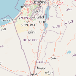
Map view of Tel Be'er Sheva National Park

Use this park location map to pinpoint Tel Be'er Sheva National Park in Israel, understand its exact geographic position, and read its mapped placement within the surrounding landscape more clearly.

Pigeon | © OpenStreetMap contributors
Park atlas

Compare the regional spread of protected landscapes, archaeological sites, and desert terrain in Israel's Negev.

Discover National Parks and Protected Areas Surrounding Tel Be'er Sheva

Explore additional national parks and protected areas near Tel Be'er Sheva National Park to trace the geographic context of Israel's Negev Desert. Compare diverse protected landscapes, ranging from historical archaeological sites to distinct desert environments, to gain broader insights into regional conservation and terrain.
National parkIsrael
About 27 km away#1 closest

East

Tel Arad National Park: Discover Israel's Protected Landscape and Mapped Geography

Explore protected area boundaries and regional terrain context.

Delve into Tel Arad National Park, a key protected area in Israel offering insights into its unique landscape and geographic setting. This park provides a focal point for understanding protected land distribution, mapped terrain features, and the regional natural context within the Levant. Utilize this atlas entry to explore the park's specific geographic identity and conservation significance.

Watercolor illustration of rolling green hills, a body of water, and grassy vegetation under a light sky.
National parkIsrael
About 32 km away#2 closest

Southeast

Mamshit National Park: Ancient Nabataean City, Byzantine Ruins, and Negev Desert Landscape

Explore exceptionally preserved Nabataean urban architecture and regional geography.

Mamshit National Park offers a rare window into ancient desert urbanism, preserving an exceptionally intact Nabataean caravan city and Byzantine settlement in Israel's Negev Desert. The site showcases unique residential compounds and religious structures, demonstrating sophisticated architectural traditions and water management systems against a backdrop of striking natural terrain. As a vital component of the Incense Road heritage, Mamshit provides rich context for understanding ancient trade, regional geography, and the enduring human adaptation to arid landscapes.

IUCN
V
Relief
Lowland
Climate
Arid
Scope
Terrestrial
Watercolor illustration showing a winding river through green hills with distant trees under a light sky
National parkIsrael
About 34 km away#3 closest

West

Eshkol National Park: Desert Wetland Oasis with Archaeological Significance in Southern Israel

Mapped protected area featuring Ein HaBesor spring and Besor valley landscapes.

Eshkol National Park showcases a rare desert wetland environment sustained by the significant Ein HaBesor spring in Israel's Northern Negev. This protected natural area offers a distinctive landscape where water nourishes lush vegetation against the backdrop of arid terrain. Beyond its ecological value, the park encompasses archaeological remnants, including the mound of Khirbet Shalala, providing a rich geographical and historical discovery context within the Besor Stream basin.

Area
3.54 km²
Relief
Lowland
Climate
Arid
Access
Easy access
National parkIsrael
About 39 km away#4 closest

North

Beit Guvrin-Maresha National Park: A Mapped Exploration of Israel's Ancient Subterranean Heritage

Discover unique bell caves and archaeological landscape in the Judean lowlands.

Beit Guvrin-Maresha National Park in Israel presents a unique atlas-style discovery of a landscape defined by ancient human excavation. Explore the vast networks of bell caves, Phoenician necropolises, and Byzantine underground churches carved into the soft limestone hillsides. This protected area offers a compelling journey through millennia of history, revealing the geography and terrain shaped by continuous habitation and burial practices, making it a vital site for understanding regional archaeology and ancient cave systems.

IUCN
V
Water
No major water
National parkIsrael
About 44 km away#5 closest

South

Ben-Gurion Tomb National Park: Protected Desert Landscape and Geographic Context

Explore the Negev Desert's unique memorial terrain.

Ben-Gurion Tomb National Park offers a distinct protected landscape experience in the heart of Israel's Negev Desert. This national park is primarily known as the burial site of David and Paula Ben-Gurion, intentionally situated in the desert overlooking the dramatic Nahal Tzin canyon. The park's approximately 90 dunams feature a carefully designed memorial garden that contrasts with the arid terrain, providing a unique focus for geographic exploration and understanding the site's regional landscape.

Area
0.09 km²
Relief
Lowland
Climate
Arid
Access
Easy access
National parkIsrael
About 45 km away#6 closest

Southwest

Shivta National Park National Park: An Atlas View of Israel's Protected Landscapes

Mapped terrain and regional geographic context for Shivta National Park.

Shivta National Park represents a key protected area, offering a focused entry into Israel's broader geographic and landscape atlas. This page provides specific details about the park's identity as a national park, its mapped terrain, and its placement within the regional context of the country. Users can explore the structured information that defines Shivta National Park's role as a protected landscape, contributing to a deeper understanding of its geographic significance and mapped features.

Climate
Arid
Access
Easy access
Scope
Terrestrial
Water
No major water
Watercolor illustration of a canyon with winding river, mountains, and rolling hills
National parkIsrael
About 47 km away#7 closest

South

Ein Avdat National Park: A Spectular Desert Oasis and Protected Landscape in Israel

Explore its unique springs, waterfalls, and ancient Nabatean and Byzantine history.

Ein Avdat National Park showcases a rare desert oasis environment, a starkly beautiful protected landscape where natural springs emerge from the Negev's arid terrain. This park is celebrated for its dramatic waterfalls, deep pools, and the preserved remnants of ancient human habitation, including a remarkable Byzantine cave monastery carved directly into the canyon walls. Its geography, shaped by the Nahal Zin wadi, provides a vivid study in desert ecosystems and their capacity for supporting life and history over millennia, making it a key site for understanding landscape context in Israel.

Area
4.8 km²
IUCN
V
Relief
Mixed relief
Climate
Arid
National parkIsrael
About 49 km away#8 closest

East

Masada National Park: Explore Israel's Iconic Protected Desert Fortress and Landscape

Discover mapped boundaries and archaeological significance in the Judean Desert.

Masada National Park preserves a remarkable historical fortress and palace complex set within the dramatic desert terrain of Israel's Judean Desert. This protected area is renowned for its archaeological importance, showcasing sophisticated ancient engineering and its role as the final stronghold of the Jewish revolt. The stark, beautiful landscape surrounding the plateau offers significant geographic context, allowing for an atlas-style exploration of its terrain, mapped boundaries, and the wider Dead Sea region.

IUCN
V
Scope
Terrestrial
Water
Minor water
Season
Year-round

Common questions about visiting, size, designation, and location context for Tel Be'er Sheva National Park

Tel Be'er Sheva National Park FAQs for park facts, access, geography, and protected area context

Find quick answers about Tel Be'er Sheva National Park, including protected-area facts, park geography, trail and visitor context, and how the park fits into its surrounding country and regional landscape.
MoriAtlas Explorer

Continue Your Protected Areas Search Across the Global Atlas

Deepen your exploration by continuing the structured search for national parks and protected areas worldwide. Utilize the comprehensive filtering capabilities to compare different conservation landscapes and refine your understanding of global park geography. Discover more about the distribution and characteristics of protected natural areas.

Global natural geography