Why Turtle Islands National Park stands out
Turtle Islands National Park is best known for its role as a sea turtle nesting sanctuary and one of the most visited turtle-watching destinations in Southeast Asia. Green turtles arrive at its beaches almost every night of the year, while hawksbill turtles also nest on the islands, and during the October peak season large numbers of females come ashore together. Equally distinctive is the way the park blends active turtle conservation, marine protection, and visitor experience on remote tropical islands, anchored by Selingaan's hatchery program, which has produced some of the longest-running sea turtle monitoring data in the world. The park's coral reef habitat also adds an important marine dimension to its identity beyond the turtles themselves.
Turtle Islands National Park history and protected-area timeline
The history of Turtle Islands National Park is tied closely to the early emergence of systematic sea turtle conservation in Malaysia. On 1 August 1966, the first turtle hatchery in Malaysia was established on Selingaan Island, funded entirely by the Sabah state government. This hatchery laid the foundation for a long-running conservation program and made Selingaan one of the earliest sites of managed turtle nesting protection in the country.
Hatcheries were subsequently set up on the other two main islands, Bakkungan Kechil (Little Bakkungan) and Gulisan (Gulisaan). The institutional role of these islands in protecting turtles was formally recognized in 1972, when Selingan, Bakkungan Kechil, and Gulisan were designated as a Game and Bird Sanctuary. Five years later, in 1977, the area's status was elevated to that of a Marine Park, creating the protected landscape that exists today as Turtle Islands National Park.
Since 1977, permanent park staff have monitored nesting turtles, protected hatchery operations, and tagged turtles as part of ongoing research. The resulting dataset makes Sabah's turtle conservation program one of the oldest in the world, and its records have helped influence broader regional understanding of sea turtle lifecycle dynamics. Administration of the park has been carried out by Sabah Parks, which continues to manage the area as an IUCN Category II protected area.
Turtle Islands National Park landscape and geographic character
The landscape of Turtle Islands National Park is defined by its island geography in the tropical Sulu Sea. The three core islands, Selingaan, Little Bakkungan, and Gulisaan, are small land masses fringed by sandy beaches, with coastal vegetation characteristic of remote tropical islands in the region. Their beaches are the most visually striking landscape feature, serving both as nesting habitat for sea turtles and as the focal point of the park's conservation work.
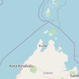
Libaran Island lies within the broader park boundaries and adds additional coastline to the protected area, although it is not a major turtle nesting site. The islands sit only a short distance north of Sandakan on mainland Sabah, but their offshore position gives them a distinctly marine character, with sea views and open-water surroundings dominating the scenery rather than inland terrain.
Surrounding the islands is an underwater landscape of coral reefs and reef-associated habitats, which form a substantial part of the park's total area. The Malay-language description of the park at 1,740 hectares and the presence of five reef monitoring stations emphasize the scale of this submerged environment. Above water, the islands combine low coastal vegetation, sandy shores, and the built infrastructure of the hatcheries and visitor facilities, producing a marine island landscape shaped as much by reef ecosystems and sea turtle activity as by terrestrial features.
Turtle Islands National Park ecosystems, habitats, and plant life
The natural character of Turtle Islands National Park is shaped by the meeting of tropical island habitat with coral reef and open ocean. The islands themselves support coastal vegetation typical of small tropical landmasses, while their most important ecological function lies in providing sandy nesting beaches for sea turtles. Because turtles come ashore at night across most of the year, the beaches function as a continuously active breeding habitat rather than a seasonally used one.
The marine environment surrounding the islands is a defining ecological element of the park. Coral reefs ring the islands and extend into the protected waters, creating habitat for reef-associated marine life. According to the park's marine management framework, the reef area is monitored through five dedicated reef monitoring stations, which track the condition of reef habitat alongside the park's broader conservation mandate. This combination of nesting beaches and reef ecosystems gives the park a dual ecological identity centered on both sea turtles and coral reef systems.
The wider ecological value of the park is amplified by its position within the larger ten-island Turtle Islands chain. The reefs, beaches, and marine waters together sustain a food base for green and hawksbill turtles and for the broader community of reef organisms, making the park a key node in a transnational marine ecosystem between Sabah and Tawi-Tawi.
Turtle Islands National Park wildlife and species highlights
Wildlife at Turtle Islands National Park is dominated by marine turtles, particularly the green turtle, which is the most prominent nesting species, and the hawksbill turtle, which also nests on the islands. Green turtles visit the beaches almost every night, and during peak season up to around fifty turtles may come ashore in a single night, producing concentrated nesting events in October.
The islands also support a community of animals naturally linked to sea turtle reproduction. Monitor lizards roam the beaches, a specialized crab preys upon turtle hatchlings, and eagles and other birds use the islands as foraging habitat, while sharks and other marine life are part of the surrounding sea. Park management deliberately leaves some nests undisturbed so that these natural predator and scavenger relationships continue to function, avoiding the unintended ecological collapse that could occur if turtle eggs were removed in their entirety.
On the water, the reef ecosystems around the islands host reef-associated marine fauna, monitored in part through the park's reef monitoring stations. Together, the terrestrial island wildlife and the marine life around the reefs give the park a layered wildlife profile in which sea turtles remain the most recognizable and ecologically central species.
Turtle Islands National Park conservation status and protection priorities
Turtle Islands National Park is one of Malaysia's most established marine turtle conservation sites and a cornerstone of sea turtle protection in Sabah. The park's conservation efforts trace back to 1966, when Sabah opened the country's first turtle hatchery on Selingaan, giving the park an unusually long record of continuous protection work. This early start has produced one of the world's oldest datasets on sea turtle nesting and population dynamics.
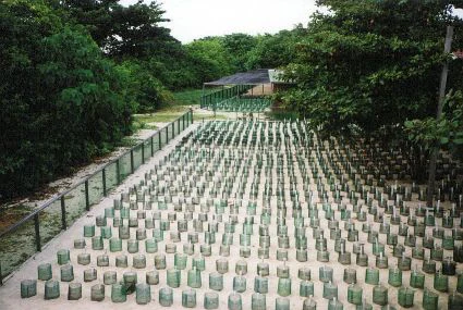
The core conservation work centers on protecting nesting beaches, operating hatcheries, and tagging turtles for ongoing research. Eggs are relocated into protected incubation chambers where predator access is controlled, while temperature management using shaded and sun-exposed sections of the hatchery plays a role in influencing hatchling sex ratios, since sea turtle sex is determined by incubation temperature. Some nests are intentionally left in place to preserve the natural predator-prey relationships on the islands, balancing intensive hatchery protection with ecosystem integrity.
The park's marine conservation role extends beyond turtles to coral reef monitoring. With five reef monitoring stations distributed across its waters, the park tracks reef health as part of a broader reef management program, reinforcing the link between turtle conservation and the maintenance of the reef habitats on which sea turtles ultimately depend. Managed since 1977 as a Marine Park and administered by Sabah Parks, the area is internationally significant as part of a shared turtle protection landscape extending into the Philippine Turtle Islands Wildlife Sanctuary across the Sulu Sea.
Top sights and standout views in Turtle Islands National Park
Turtle Islands National Park stands out for combining almost year-round green and hawksbill turtle nesting, coral reef habitat, and a long-running hatchery program into a single compact marine park. Its transboundary setting, with seven sister islands in the Philippine Turtle Islands Wildlife Sanctuary, gives it regional conservation significance beyond its small size.
The park is also distinguished by its structured visitor experience. Overnight stays on Selingaan are tied directly to the conservation workflow, from observing a nesting female to releasing hatchlings into the sea at night. Combined with monitor lizards, eagles, sharks, and reef life around the islands, the park offers a uniquely focused encounter with sea turtle conservation set within a tropical island and reef landscape.