Why Wallis Island Nature Reserve stands out
Wallis Island Nature Reserve is best known for protecting a sizeable tract of estuarine island habitat within the Wallis Lake system, including wet heathlands, shrublands, swamps, and a permanent lagoon that can be crossed on a graveled walking trail. It is also notable as a protected landscape layered over a long Indigenous and European cultural history, with the Worimi people as the traditional custodians of the surrounding region. The reserve is the flagship of a broader group of eight nature reserves encircling Wallis Lake, and it represents one of the more substantial coastal heath and lagoon systems preserved along the New South Wales mid-north coast.
Wallis Island Nature Reserve history and protected-area timeline
The lands and waters around Wallis Lake have a deep Indigenous history. The Worimi people are the traditional custodians of this stretch of the New South Wales coast, and Wallis Island preserves physical evidence of their long occupation in the form of shell middens and tool sites.
European contact began turbulently in 1790, when five convicts escaping from the Second Fleet reached the broader region before being recaptured. Sustained contact soon followed and had a heavy impact on the Worimi. In 1818, explorer John Oxley visited the area and named the lake after Captain Samuel Wallis, the commander of that mission. In 1825 the Australian Agricultural Company received a grant of around a million acres for farming but later returned the land because the soil proved unsuitable, after which the region turned to timber harvesting by lumberjacks. By the 1850s, Chinese workers who had been brought in as shepherds by the company had begun settling locally and engaging in fishing, and by the late 1800s several English settlers had also established themselves in the area.
The University of New South Wales ran a research station on or near the island until the 1980s, and during this period growing recognition of the island's natural values led to its formal protection. Wallis Island Nature Reserve was established in January 1983. An initial area of 133 hectares was later expanded by 340 hectares in December 1997 and by another 111 hectares in December 2005, bringing the reserve to its current substantial footprint within the Wallis Lake system.
Wallis Island Nature Reserve landscape and geographic character
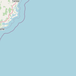
Wallis Island sits within Wallis Lake, a broad, relatively shallow estuarine water body of around 99 square kilometers that connects to the Tasman Sea near Forster and Tuncurry. The reserve occupies most of the island, with the lake surrounding its edges and the Coolongolook River flowing into the same estuarine system just to the north.
The island's terrain is low-lying and defined by wetland and heath vegetation rather than dramatic relief. A permanent lagoon is a defining landscape feature on the island itself, and it is crossed by the Wallis Island Main Trail, an elevated gravelled road that ties together the reserve's interior. Wet heathlands, shrublands, and swamps dominate the natural ground cover, producing an open, scrubby coastal landscape quite distinct from dense forest.
Wallis Island Nature Reserve ecosystems, habitats, and plant life
The reserve's ecological character is shaped by the meeting of estuarine, wetland, and coastal heath environments. Wallis Lake provides brackish, sheltered water conditions, while the island's interior carries freshwater-influenced habitats in the form of the permanent lagoon and surrounding swamps.
The vegetation pattern is dominated by wet heathlands and shrublands, with swamps filling the wetter low-lying areas. This combination gives the reserve an open, mosaic-like habitat structure typical of low-elevation coastal environments on the New South Wales mid-north coast, and supports the ecological transition between true marine influence and inland terrestrial systems.
Wallis Island Nature Reserve wildlife and species highlights
The source material does not provide detailed species-level information about Wallis Island Nature Reserve's fauna. The reserve's mix of wet heathland, shrubland, swamp, and estuarine lagoon suggests conditions typical of New South Wales coastal lagoon environments, but specific wildlife identities, bird lists, or mammal records are not documented in the available content.
Wallis Island Nature Reserve conservation status and protection priorities
Wallis Island Nature Reserve is significant as the largest protected area within a cluster of eight nature reserves encircling Wallis Lake, securing a substantial portion of an estuarine island under formal protection on the New South Wales mid-north coast.
Its establishment in 1983 and subsequent expansions in 1997 and 2005 reflect ongoing recognition of the island's natural values, including its heath, swamp, and lagoon habitats, as well as the cultural landscape associated with long Indigenous use of the broader lake region. The reserve represents a meaningful commitment to protecting coastal wetland and heath ecosystems in a region otherwise shaped by tourism, settlement, and recreational fishing.
Wallis Island Nature Reserve cultural meaning and human context
Wallis Island carries a layered cultural history. The Worimi people are the traditional custodians of the Wallis Lake region, and the island preserves middens and tool sites that record their long occupation of these waters and shores.
European arrival began with the 1790 Second Fleet convicts and was followed by John Oxley's 1818 exploration that gave the lake its current name. Nineteenth-century land use brought Australian Agricultural Company farming experiments, timber harvesting by lumberjacks, Chinese settlement tied originally to shepherding work, and English farming families. A University of New South Wales research station operated locally until the 1980s, and more recent decades have seen private estate development on parts of the island, including the well-known Chateau Le Marais retreat and a private airfield.
Top sights and standout views in Wallis Island Nature Reserve
Wallis Island Nature Reserve's strongest distinguishing features are its size within the Wallis Lake reserve network, its combination of wet heathland, shrubland, swamp, and a permanent lagoon, and its layered cultural heritage from Worimi occupation through 19th-century settlement to modern protection. The elevated gravelled Wallis Island Main Trail, which crosses the island's lagoon, is a defining access feature, and the reserve's location within a 99-square-kilometer estuarine lake system gives it a distinctive coastal-lagoon character that sets it apart from open-ocean national parks along the New South Wales coast.
Best time to visit Wallis Island Nature Reserve
The available source material does not provide reliable enough seasonality detail to support substantive visit-timing guidance for Wallis Island Nature Reserve. A general understanding of the New South Wales mid-north coast climate would suggest milder and drier conditions outside the warmest and wettest months, but this level of operational advice is not anchored in the provided content.