
Streams
Park geography
Examining the boundaries, terrain features, and regional landscape context
Whanganui National Park Detailed Geographic Profile and Mapped Land Area Analysis
Analyze the structured geographic data for Whanganui National Park, covering its 742 square kilometer extent and expansive 587 kilometer perimeter. This profile examines the temperate lowland terrain, including notable peaks like Te Mata and Ratanui, alongside waterfall locations and broad temperate broadleaf forest habitats situated across the region.
Related tags
National ParkNew ZealandNorth IslandForest ConservationRiver Valley
Ancient river valley wilderness with deep Māori heritage on New Zealand's North Island
Whanganui National Park
Whanganui National Park is a protected wilderness area located on New Zealand's North Island, established in 1986 and encompassing approximately 742 square kilometres of terrain bordering the Whanganui River. The park represents one of New Zealand's most culturally significant natural areas, with a landscape shaped by millennia of Māori occupation and European settlement history. The region features extensive lowland podocarp-hardwood forests, deep river valleys, and rugged hill country that collectively create a distinctive wilderness character. What sets Whanganui apart from other New Zealand national parks is its profound connection to human settlement; the Department of Conservation specifically identifies it as the national park most closely tied to Māori and European historical use. The Whanganui River itself, though not forming part of the protected area, remains the park's central feature and serves as the pathway for the renowned Whanganui Journey, one of New Zealand's Great Walks.
- Location
- New Zealand
- Park type
- National park
- Established
- 1986
- Area
- 742 km²
Location overview
National park positioning and administrative location in New Zealand
Geographic Location and Regional Setting of Whanganui National Park
Whanganui National Park is located entirely within the national borders of New Zealand. Protected status applies inland without coastal or transboundary crossings, establishing a distinct regional conservation footprint.
- Countries
- New Zealand
- Primary location
- New Zealand
- Geographic setting
- Inland
Boundary and coordinates
Interactive spatial outline, coordinate limits, and area metrics
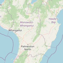
Whanganui National Park Boundary Map and Geographic Extent
Mapped boundary geometry delivers complete spatial context for the protected territory. Accompanying dimensional metrics outline total area coverage, geographic span, and coordinate limits.
- Boundary area
- 759.6 km²
- Boundary perimeter
- 587.8 km
- Northernmost point
- 38.926° S
- Southernmost point
- 39.7348° S
- Easternmost point
- 175.2448° E
- Westernmost point
- 174.7621° E
- Geographic centre
- 39.3142° S, 174.9682° E
- North–south span
- 89.8 km
- East–west span
- 41.6 km
Terrain and natural features
Explore recorded streams, peaks, and river basins within the protected area.
Whanganui National Park Terrain and Named Natural Features
Stored lowland terrain classifications define the broad landscape context across the protected area. Linked feature cards supply recorded names, types, and spatial relationships for inner natural features.
Selected named natural features
Peaks
Parikoritaua
553 m
Rivers
Ahuahu Stream
Peaks
Mangatawai
509 m
Peaks
Te Anaohiti
397 m
Rivers
Whangamōmona River
Environmental setting
Temperate broadleaf forest cover, lowland relief, and river landscapes
Whanganui National Park Environmental Classification and Physical Setting
Stored classifications combine to outline the temperate forest cover, lowland relief, and river features across the terrain. Recorded categories connect directly to corresponding atlas destinations for wider geographic context.
- Relief
- Lowland
- Climate
- Temperate
- Water
- Minor water
- Forest cover
- Mostly forested
- Seasonality
- Year-round
Landscape features
Forest · Rivers
Habitat types
Temperate broadleaf forest
Park atlas
Compare Whanganui's River Valley Wilderness with Surrounding North Island Protected Landscapes
Explore Nearby National Parks and Protected Areas Beyond Whanganui National Park
Continue your exploration from Whanganui National Park to browse other national parks and protected areas across New Zealand's North Island, tracing diverse conservation landscapes. Compare various park types, river valleys, and forest reserves to understand the regional spread of New Zealand's unique protected wilderness.
National parkNew Zealand
22 km away#1 closest
Northeast

Tongariro National Park: New Zealand's Premier Volcanic National Park Atlas
Explore mapped terrain, active volcanoes, and unique dual World Heritage values.
Tongariro National Park, situated in New Zealand's North Island, is a globally significant protected area celebrated for its dramatic volcanic landscapes and profound cultural heritage. As the nation's oldest national park, it features three active volcanoes: Mount Ruapehu, Mount Ngauruhoe, and Mount Tongariro, set within a diverse terrain that includes forests, alpine zones, and the Rangipo Desert. Its dual World Heritage status underscores its importance for both natural attributes and its sacred cultural landscape, offering rich opportunities for geographic and atlas exploration.
- Area
- 795.96 km²
- Established
- 1887
- IUCN
- II
- Relief
- Mountain
Protected landscapeWaikato
25 km away#2 closest
North
Pureora Forest Park: Ancient Rainforests and Protected Mountain Landscapes in Waikato
Regional geography and mapped native forest boundaries
Pureora Forest Park represents a significant protected area in the central North Island of New Zealand, defined by its towering podocarp giants and complex volcanic terrain. The park serves as a prime example of an intact rainforest ecosystem, featuring dense broadleaf canopies, deep river valleys, and significant remnants of ancient forest history. Its geography, shaped by both geological upheaval and centuries of growth, provides an essential record of the natural heritage preserved across the Waikato and Manawatu-Whanganui regions.
- Area
- 759.57 km²
- Established
- 1978
- Relief
- Mountain
- Water
- Major water bodies
Marine protected areaNew Plymouth District
39 km away#3 closest
Northwest
Parininihi Marine Reserve: A Detailed Atlas of New Zealand's Coastal Marine Protected Area
Mapping the ecological sanctuary and reef geography in the New Plymouth District.
Gain insights into the geography of Parininihi Marine Reserve, a protected marine environment north-east of New Plymouth. This record outlines the reserve's structural features, from the iconic White Cliffs coastline to the complex underwater canyons and pinnacles of the Pariokariwa Reef. Learn about the seafloor terrain and the ecological distribution of invertebrate colonies and fish populations that define this crucial New Zealand marine reserve.
- Area
- 18 km²
- Established
- 2006
- Relief
- Lowland
- Climate
- Temperate
National parkNew Zealand
49 km away#4 closest
West
Egmont National Park: New Zealand's Distinctive Volcanic National Park
Explore the mapped volcanic terrain and protected landscape of Mount Taranaki.
Egmont National Park represents a significant protected area within New Zealand's North Island, dominated by the iconic stratovolcano, Mount Taranaki. This national park is celebrated for its distinct circular protected boundary, a unique feature against the surrounding pastoral farmlands, and its dramatic volcanic landscape. Visitors can explore a range of natural habitats from dense temperate rainforests to alpine environments, all mapped within this significant conservation landmark.
- Area
- 341.7 km²
- Established
- 1900
- IUCN
- II
- Visitors
- 400K annual
Protected areaManawatu-Whanganui Region
53 km away#5 closest
Northeast
Kaimanawa Forest Park: A Deep Dive into Protected Forest Terrain and Regional Mountain Geography
Remote backcountry wilderness within the Manawatu-Whanganui Region
Spanning the high country of the Rangitikei District, Kaimanawa Forest Park offers a vast, forested wilderness experience distinct from the surrounding volcanic cones. This atlas entry details the park's structural role as a protected conservation area, tracing its boundaries across rugged mountain ridges and deep valleys that define the heart of New Zealand's central North Island landscape.
- Area
- 759.57 km²
- Established
- 1969
- Relief
- Mountain
- Climate
- Temperate
Protected landscapeHawke's Bay
83 km away#6 closest
East
Kaweka Forest Park: Protected Landscape and Mountain Geography in Hawke's Bay
High-altitude alpine terrain and forest reserve mapping
Kaweka Forest Park represents a massive block of protected country in the central North Island, defined by the Kaweka Range and its prominent 1,724-metre summit. The landscape shifts from managed pine plantations to rugged, dissected mountain ridges, offering a unique study in New Zealand's interior geography, native ecological restoration, and geothermal features like the Mangatutu Hot Springs.
- Area
- 594.26 km²
- Established
- 1972
- Relief
- Mountain
- Climate
- Temperate
Protected areaNew Zealand
About 105 km away#7 closest
North
Pirongia Forest Park: Mapped Geography and Protected Landscapes in the Waikato Region
Volcanic summits and native podocarp forest boundaries
Gain a deeper understanding of Pirongia Forest Park through its complex volcanic geology and dense native vegetation. This resource outlines the park's fragmented ridges, limestone stream systems, and its role as a biogeographic bridge within the Waikato landscape of New Zealand.
- Area
- 167.7 km²
- Established
- 1971
- Relief
- Mountain
- Climate
- Temperate
Wildlife reserveWaikato
About 116 km away#8 closest
North
Kārewa / Gannet Island Wildlife Reserve: Waikato Offshore Protected Landscape Mapping
Geological tuff ring remnant and significant seabird sanctuary
Kārewa / Gannet Island serves as a crucial wildlife sanctuary and volcanic marker on the Waikato coast. This ancient tuff ring fragment rises from the seafloor to host an extensive gannet breeding population, offering a concentrated study of offshore geological and biological isolation within New Zealand's protected area network.
- Relief
- Lowland
- Climate
- Temperate
- Access
- Remote access
- Scope
- Mixed
MoriAtlas Explorer
Continue Exploring Whanganui National Park's Geography and Mapped Boundaries
Deepen your understanding of Whanganui National Park's protected landscape, its place within the broader regional geography, and the unique characteristics that define this significant area. Discover the mapped terrain and context that make Whanganui National Park a distinct entry in New Zealand's atlas of protected lands.
Browse next
Global natural geography
Explore related park routes
Explore MoriAtlas Global ParksBrowse All MoriAtlas ParksGlobal Park Map DiscoveryMoriAtlas: Browse All CountriesBrowse All MoriAtlas ContinentsNational Park Environment AtlasGrand Canyon National Park AtlasYellowstone National Park AtlasYosemite National Park Atlas and GeographySerengeti National Park AtlasGalápagos National Park Protected LandscapeBanff National Park Geography and AtlasKruger National Park Atlas EntryUluṟu-Kata Tjuṯa National Park AtlasExplore Uluru-Kata Tjuta National Park GeographyPlitvice Lakes National Park AtlasFiordland National Park Protected LandscapeGreat Smoky Mountains National Park AtlasAfghanistan National Parks and Protected AreasAlbania National Parks and Protected AreasAlgeria National Parks and Protected AreasAmerican Samoa National Parks and Protected AreasAndorra National Parks and Protected AreasAngola National Parks and Protected AreasAntarctica National Parks and Protected AreasAntigua and Barbuda Park List