Mori Atlas logo
National parkWhanganui National Park

Discover the mapped boundaries and unique geographic context of this significant protected area.

Whanganui National Park: New Zealand's Protected River Valley Landscape and Atlas

Whanganui National Park, situated on New Zealand's North Island, stands as a protected national park with approximately 742 square kilometers of diverse terrain centered around the iconic Whanganui River valley. Established to preserve extensive lowland podocarp-hardwood forests and rugged hill country, this park offers a profound connection to both Māori cultural heritage and early European settlement history. Its landscape is shaped by the meandering river and the surrounding remote wilderness, making it a crucial area for understanding regional geography and protected land distribution in New Zealand.

National ParkNew ZealandNorth IslandForest ConservationRiver ValleyGreat Walk

Whanganui National Park

National park

Park overview

Structured park overview, official facts, and landscape profile for Whanganui National Park

Whanganui National Park park facts, protected area profile, and essential visitor context

Review the core facts for Whanganui National Park, including designation, size, terrain, visitor scale, habitats, and operating context in one park-focused overview.

About Whanganui National Park

Whanganui National Park occupies a significant portion of the Whanganui River catchment on New Zealand's North Island, protecting a landscape of considerable ecological and cultural importance. The park was established in 1986 through the consolidation of Crown land, former state forest, and several reserves, creating a contiguous protected area that spans diverse terrain from river flats to hill country. The Whanganui River flows alongside and through the park boundary, serving as both the ecological heart of the region and the pathway for one of New Zealand's most celebrated multi-day tramping experiences. The park's position on the North Island's western slopes exposes it to moisture-laden winds from the Tasman Sea, supporting the dense forest cover that characterises much of the protected area. Unlike many New Zealand national parks that are celebrated primarily for alpine or volcanic landscapes, Whanganui's significance lies in its lowland forest ecosystems and its continuous connection to human history, making it unique among the country's protected areas.

Quick facts and research context for Whanganui National Park

Whanganui National Park covers 742 square kilometres on the North Island of New Zealand, established in 1986 under the management of the Department of Conservation. The park protects significant areas of lowland podocarp-hardwood forest, with species including kāmahi, tawa, rimu, mīro, tōtara, kahikatea, mataī, and nīkau palm. The park's defining waterway is the Whanganui River, which has served as a major trade and communication route for Māori communities for centuries. The park contains notable historical features including the Bridge to Nowhere and the Tīeke Marae/Kāinga, both accessible via the Whanganui Journey Great Walk.

Protection and recognition

Understanding the terrestrial scope, conservation status, and official designation data.

Whanganui National Park Protection Status and Terrestrial Designation

Explorers can verify the documented terrestrial protection status and designated conservation framework of Whanganui National Park. Analyzing verified boundary parameters and environmental designations provides essential clarity for mapping regional conservation networks.

Protection details

Protection scope
Terrestrial
Transboundary protection
No
Park context

Deeper park guide and search-rich context for Whanganui National Park

Whanganui National Park history, landscape, wildlife, and travel context

Explore Whanganui National Park through its history, landscape character, ecosystems, wildlife, conservation priorities, cultural context, and seasonal travel timing in a structured park guide built for atlas discovery and search intent.

Why Whanganui National Park stands out

Whanganui National Park is best known for its exceptional combination of natural wilderness and cultural heritage, centred around the Whanganui River valley. The park protects one of New Zealand's largest remaining areas of lowland forest, providing crucial habitat for threatened species including the North Island brown kiwi and the endangered blue duck (whio). The Whanganui Journey is the park's flagship experience, a multi-day kayaking and tramping route that follows the river through pristine forest, past historic sites, and to remote landscapes that remain largely inaccessible by road. The Bridge to Nowhere stands as a poignant reminder of early 20th century European settlement attempts, while Tīeke Marae represents ongoing Māori cultural connection to the land.

Whanganui National Park history and protected-area timeline

The Whanganui River valley has been a corridor of human activity for centuries, with Māori communities establishing extensive networks of pā (fortified villages) along the river banks throughout what is now the park. The river served as the main route into the central North Island, functioning as a major trade and communication pathway for Te Āti Haunui-a-Pāpārangi and related iwi (tribes). This network was described as 'the plaited rope of Hinengākau', a metaphor reflecting the interconnected nature of the river settlements. The mid to late 19th century brought significant change, with wheat cultivation becoming widespread and flour mills built between the 1840s and 1860s to process grain for trade. Following European arrival, the region became a centre of religious conversion in the 1840s, leading to the establishment of Christian communities and chapels along the river, while followers of the Pai Mārire religion also established nearby settlements. The Bridge to Nowhere represents the park's more recent settlement history, constructed as part of the Soldier-Settler Scheme that offered returned World War I servicemen discounted land and development loans in the Mangapurua and Kaiwhakauka valleys. At its peak in the 1930s, the area supported dozens of farms, but by the 1940s the settlements had been abandoned due to challenging conditions including flooding and erosion. Today the bridge stands as a historic landmark within the park, maintained by the Department of Conservation.

Whanganui National Park landscape and geographic character

The physical landscape of Whanganui National Park is defined by the deep, winding valley of the Whanganui River and the surrounding hill country of the North Island's western interior. The terrain ranges from relatively flat river flats adjacent to the watercourse to steep, forested slopes climbing away from the valley floor. The park protects extensive areas of lowland forest that blanket the hillsides and fill the valleys, creating a landscape of considerable remoteness and wilderness character despite its proximity to populated areas. The river itself has carved a meandering course through the terrain, with its banks and adjacent flats supporting distinct vegetation communities adapted to the riparian environment. The surrounding terrain is typical of the central North Island's hill country, with ridges and valleys creating a complex topography that limits access and contributes to the park's isolated character.

Whanganui National Park ecosystems, habitats, and plant life

Whanganui National Park protects one of New Zealand's most significant areas of lowland podocarp-hardwood forest, a habitat type that has been substantially reduced across the country through historical land clearance. The forest communities within the park are diverse and structurally complex, with towering podocarp species including rimu, mīro, and tōtara dominating the steeper terrain, while kāmahi and tawa form the canopy in other areas. The lower-lying areas near the river support distinctive species including kahikatea, mataī, and the nīkau palm, New Zealand's only native palm species. Large northern rātā trees are scattered throughout the forest, adding to the diversity and visual character of the park's vegetation. This extensive forest cover supports a corresponding richness of native wildlife, with the park protecting several thousand threatened North Island brown kiwi and the endangered blue duck, both species of major conservation concern in New Zealand.

Whanganui National Park wildlife and species highlights

The wildlife of Whanganui National Park reflects the park's extensive forest cover and riverine habitats, supporting both significant populations of threatened species and diverse communities of more common native birds. The park provides crucial habitat for several thousand North Island brown kiwi, a species that has suffered dramatic declines across its range due to introduced predators, making the protected populations within Whanganui nationally significant. The endangered blue duck, known in Māori as whio, inhabits the park's rivers and streams, relying on the clean, fast-flowing water of the Whanganui system. The forest canopy and understory support a rich bird community including grey warbler, yellow-crowned kākāriki, New Zealand falcon (kārearea), New Zealand pigeon (kererū), rifleman (titipounamu), silvereye, tomtit, tūī, and whitehead. The river itself supports native fish species including freshwater crayfish (kōura), black flounder, pouched lamprey, and eels, all of which form part of the aquatic ecosystem that makes the Whanganui system ecologically significant.

Whanganui National Park conservation status and protection priorities

Whanganui National Park plays a vital role in protecting New Zealand's biodiversity, particularly through its conservation of extensive lowland forest habitats that have been heavily modified across much of the country. The park's populations of North Island brown kiwi represent one of the more significant remaining strongholds for this threatened species, with the protected forest environment offering some refuge from the introduced predators that have driven dramatic declines elsewhere. The blue duck populations within the park contribute to national conservation efforts for this endangered species, which is endemic to New Zealand and depends on healthy river systems. The forest communities themselves protect native vegetation that has survived where surrounding lands have been converted to agriculture or other uses, preserving genetic reservoirs of species including podocarps and hardwoods that once dominated much of the North Island. The Department of Conservation manages the park as part of New Zealand's national park system, balancing protection objectives with sustainable recreational use through the Great Walk network.

Whanganui National Park cultural meaning and human context

Whanganui National Park holds exceptional cultural significance for Māori, particularly for Te Āti Haunui-a-Pāpārangi and related iwi whose ancestors occupied the river valley for centuries before European colonisation. The Whanganui River was historically a major artery of Māori life, connecting communities and facilitating trade throughout the central North Island, with the riverbanks lined with pā and settlement sites. The landscape contains ongoing Māori connection to the land, exemplified by the Tīeke Marae/Kāinga, a marae and hut complex on the Whanganui Journey that was established in the early 1990s by members of Tamahaki who trace their ancestry to the original community. The land upon which Tīeke sits remains subject to a dispute between Te Whānau o Tieke and the Crown regarding historical confiscation, with the site currently co-managed by the Department of Conservation and the Māori community. This deep cultural layering distinguishes Whanganui from most other New Zealand national parks, where Māori connection, while present, is typically less continuous or contested.

Top sights and standout views in Whanganui National Park

The Whanganui Journey stands as the park's premier experience, a multi-day Great Walk that follows the river through pristine forest past historic sites and remote landscapes accessible only by water. The Bridge to Nowhere offers a tangible connection to early 20th century settlement history, its steel-reinforced concrete structure standing as a monument to the Soldier-Settler Scheme era. Tīeke Marae/Kāinga provides visitors with an opportunity to experience Māori cultural heritage in a living context, with the site offering accommodation and cultural programmes. The extensive lowland forest, home to threatened kiwi and blue duck, represents one of New Zealand's most significant remaining areas of unmodified native forest. The river itself, though not technically within the park boundary, forms the ecological and experiential heart of the protected area.

Best time to visit Whanganui National Park

The Whanganui Journey and other park activities can be undertaken throughout the year, with each season offering different character to the experience. Summer months (December to February) typically offer more stable weather and longer daylight hours, making them popular for multi-day kayak and tramping trips, though this period also coincides with higher visitor numbers. Winter visits can present challenges including wet conditions and shorter days, but also offer the opportunity to experience the park in more solitude and to witness the forest in its seasonal character. The shoulder seasons of autumn and spring often provide a balance of favorable conditions with fewer visitors, though weather can be less predictable. Regardless of season, visitors should be prepared for the possibility of rain, as the western North Island's climate delivers regular precipitation to the park's forests.
Monthly climate preview

Analyzing long-term temperature ranges and precipitation rhythms across the regional terrain

Average Temperature and Weather by Month in Whanganui National Park

Decades of climate data from a central coordinate show mild average temperatures peaking near 16.6 degrees Celsius alongside consistent year-round rainfall. Accessing the complete monthly profile reveals shifting frost risks during cooler months and detailed daily precipitation averages across the seasons.
Annual mean11 °C
7 °C17 °C
Jan16°
Feb17°
Mar15°
Apr12°
May10°
Jun
Jul
Aug
Sep
Oct10°
Nov12°
Dec14°
Warmest month
February

16.7 °C

Coolest month
July

6.7 °C

Wettest month
June

3.9 mm/day

Driest month
January

2.3 mm/day

Park location guide

Geography guide, regional context, and park location map for Whanganui National Park

Whanganui National Park park geography, regions, and map view in New Zealand

Understand where Whanganui National Park sits in New Zealand through a broader geographic reading of the surrounding landscape, nearby location context, and its mapped position within the national park landscape.

How Whanganui National Park fits into New Zealand

New Zealand is an island nation in the southwestern Pacific Ocean comprising two main islands and numerous smaller islands. Located east of Australia across the Tasman Sea, it features varied topography with the Southern Alps running along the South Island and volcanic terrain on the North Island. The country was settled by Maori people between 1280 and 1350, followed by European exploration beginning in 1642, and became a Dominion in 1907 before gaining full independence in 1947.

Wider geography shaping Whanganui National Park in New Zealand

New Zealand lies in the southwestern Pacific Ocean, east of Australia across the Tasman Sea. The country consists of two main islands, the North Island and South Island, plus over 600 smaller islands. The North Island features volcanic plateaus and hills while the South Island is dominated by the Southern Alps mountain range. The country has a long coastline and is surrounded by the Pacific Ocean.

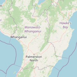
Map view of Whanganui National Park

Use this park location map to pinpoint Whanganui National Park in New Zealand, understand its exact geographic position, and read its mapped placement within the surrounding landscape more clearly.

Pigeon | © OpenStreetMap contributors
Natural feature types

Browse the Geography and Natural Features of Whanganui National Park

Examine the topographical details and landmark features that characterize the rugged landscape of Whanganui National Park. Through MoriAtlas, trace the relationship between the river valleys and the expansive forest tracts that constitute this protected region of New Zealand.
Recorded earthquake history

Browse Documented Earthquake Records for Whanganui National Park

Examine the historical seismic catalogue for Whanganui National Park to understand local ground movement trends. MoriAtlas provides clear, data-driven records of past earthquake events associated with this wilderness area, offering a valuable reference for regional geographic and geological documentation.

Whanganui National Park Earthquake History

Catalogued events

525 events

Strongest magnitude

Magnitude 6.2

Most recent event

Jul 24, 2026

This history includes earthquakes recorded inside the park or within 50 km of its borders

Park atlas

Compare Whanganui's River Valley Wilderness with Surrounding North Island Protected Landscapes

Explore Nearby National Parks and Protected Areas Beyond Whanganui National Park

Continue your exploration from Whanganui National Park to browse other national parks and protected areas across New Zealand's North Island, tracing diverse conservation landscapes. Compare various park types, river valleys, and forest reserves to understand the regional spread of New Zealand's unique protected wilderness.
National parkNew Zealand
22 km away#1 closest

Northeast

Tongariro National Park: New Zealand's Premier Volcanic National Park Atlas

Explore mapped terrain, active volcanoes, and unique dual World Heritage values.

Tongariro National Park, situated in New Zealand's North Island, is a globally significant protected area celebrated for its dramatic volcanic landscapes and profound cultural heritage. As the nation's oldest national park, it features three active volcanoes: Mount Ruapehu, Mount Ngauruhoe, and Mount Tongariro, set within a diverse terrain that includes forests, alpine zones, and the Rangipo Desert. Its dual World Heritage status underscores its importance for both natural attributes and its sacred cultural landscape, offering rich opportunities for geographic and atlas exploration.

Area
795.96 km²
Established
1887
IUCN
II
Relief
Mountain
Protected landscapeWaikato
25 km away#2 closest

North

Pureora Forest Park: Ancient Rainforests and Protected Mountain Landscapes in Waikato

Regional geography and mapped native forest boundaries

Pureora Forest Park represents a significant protected area in the central North Island of New Zealand, defined by its towering podocarp giants and complex volcanic terrain. The park serves as a prime example of an intact rainforest ecosystem, featuring dense broadleaf canopies, deep river valleys, and significant remnants of ancient forest history. Its geography, shaped by both geological upheaval and centuries of growth, provides an essential record of the natural heritage preserved across the Waikato and Manawatu-Whanganui regions.

Area
759.57 km²
Established
1978
Relief
Mountain
Water
Major water bodies
Marine protected areaNew Plymouth District
39 km away#3 closest

Northwest

Parininihi Marine Reserve: A Detailed Atlas of New Zealand's Coastal Marine Protected Area

Mapping the ecological sanctuary and reef geography in the New Plymouth District.

Gain insights into the geography of Parininihi Marine Reserve, a protected marine environment north-east of New Plymouth. This record outlines the reserve's structural features, from the iconic White Cliffs coastline to the complex underwater canyons and pinnacles of the Pariokariwa Reef. Learn about the seafloor terrain and the ecological distribution of invertebrate colonies and fish populations that define this crucial New Zealand marine reserve.

Area
18 km²
Established
2006
Relief
Lowland
Climate
Temperate
National parkNew Zealand
49 km away#4 closest

West

Egmont National Park: New Zealand's Distinctive Volcanic National Park

Explore the mapped volcanic terrain and protected landscape of Mount Taranaki.

Egmont National Park represents a significant protected area within New Zealand's North Island, dominated by the iconic stratovolcano, Mount Taranaki. This national park is celebrated for its distinct circular protected boundary, a unique feature against the surrounding pastoral farmlands, and its dramatic volcanic landscape. Visitors can explore a range of natural habitats from dense temperate rainforests to alpine environments, all mapped within this significant conservation landmark.

Area
341.7 km²
Established
1900
IUCN
II
Visitors
400K annual
Protected areaManawatu-Whanganui Region
53 km away#5 closest

Northeast

Kaimanawa Forest Park: A Deep Dive into Protected Forest Terrain and Regional Mountain Geography

Remote backcountry wilderness within the Manawatu-Whanganui Region

Spanning the high country of the Rangitikei District, Kaimanawa Forest Park offers a vast, forested wilderness experience distinct from the surrounding volcanic cones. This atlas entry details the park's structural role as a protected conservation area, tracing its boundaries across rugged mountain ridges and deep valleys that define the heart of New Zealand's central North Island landscape.

Area
759.57 km²
Established
1969
Relief
Mountain
Climate
Temperate
Protected landscapeHawke's Bay
83 km away#6 closest

East

Kaweka Forest Park: Protected Landscape and Mountain Geography in Hawke's Bay

High-altitude alpine terrain and forest reserve mapping

Kaweka Forest Park represents a massive block of protected country in the central North Island, defined by the Kaweka Range and its prominent 1,724-metre summit. The landscape shifts from managed pine plantations to rugged, dissected mountain ridges, offering a unique study in New Zealand's interior geography, native ecological restoration, and geothermal features like the Mangatutu Hot Springs.

Area
594.26 km²
Established
1972
Relief
Mountain
Climate
Temperate
Protected areaNew Zealand
About 105 km away#7 closest

North

Pirongia Forest Park: Mapped Geography and Protected Landscapes in the Waikato Region

Volcanic summits and native podocarp forest boundaries

Gain a deeper understanding of Pirongia Forest Park through its complex volcanic geology and dense native vegetation. This resource outlines the park's fragmented ridges, limestone stream systems, and its role as a biogeographic bridge within the Waikato landscape of New Zealand.

Area
167.7 km²
Established
1971
Relief
Mountain
Climate
Temperate
Wildlife reserveWaikato
About 116 km away#8 closest

North

Kārewa / Gannet Island Wildlife Reserve: Waikato Offshore Protected Landscape Mapping

Geological tuff ring remnant and significant seabird sanctuary

Kārewa / Gannet Island serves as a crucial wildlife sanctuary and volcanic marker on the Waikato coast. This ancient tuff ring fragment rises from the seafloor to host an extensive gannet breeding population, offering a concentrated study of offshore geological and biological isolation within New Zealand's protected area network.

Relief
Lowland
Climate
Temperate
Access
Remote access
Scope
Mixed

Common questions about visiting, size, designation, and location context for Whanganui National Park

Whanganui National Park FAQs for park facts, access, geography, and protected area context

Find quick answers about Whanganui National Park, including protected-area facts, park geography, trail and visitor context, and how the park fits into its surrounding country and regional landscape.
MoriAtlas Explorer

Continue Your Protected Areas Search Across the Global Atlas

Deepen your exploration by continuing the structured search for national parks and protected areas worldwide. Utilize the comprehensive filtering capabilities to compare different conservation landscapes and refine your understanding of global park geography. Discover more about the distribution and characteristics of protected natural areas.

Global natural geography